The La Plata hiking route in Gran Canaria (literally, the Silver Route) crosses the beautiful and rugged interior of the island along a path that for a long time served as a means of communication between the southern and northern slopes of the island.
This route has its origins in the need to transport the large herds of cattle in search of the abundant pastures of the southern lands after the winter rainy season. This transhumance was known as the ‘mudá del ganado’.
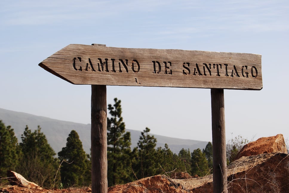
Thus, it’s a route that endured a huge commercial bustle and was also used intensively by the pilgrims who walked the Way of Saint James in Gran Canaria every July to venerate the Apostle in Tunte.
It’s undoubtedly one of the most spectacular works of road engineering in the Canary Islands, with a socio-economic importance of incalculable value for the inhabitants of the round island.
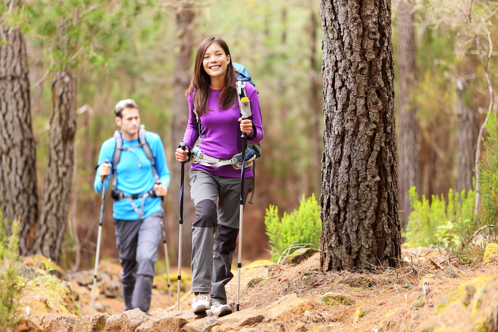
This amazing creation in Gran Canaria, which in the past facilitated the transit of traders, livestock and shepherds, muleteers, beasts of burden, artisans, neighbours and pilgrims, is now travelled by tourists, mountaineers and hikers.
La Plata Hiking Trail Route in Gran Canaria (9,6 km)
This trekking route follows a road used by humans and livestock that the ancient settlers of Gran Canaria used to move their animals in search of the best pastures each season.
With the improvements paid for out of pocket by a wealthy landowner at the end of the 19th century, the Gran Canarian people were able to avoid the geographical features of the peaks to the south when road communications were non-existent.
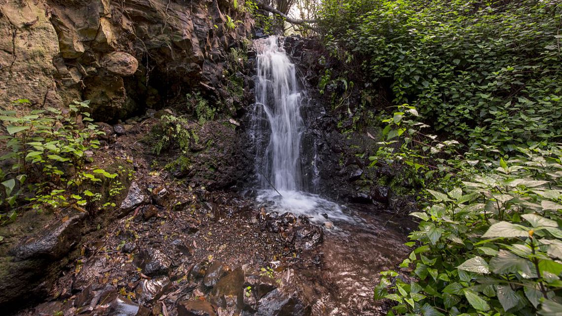
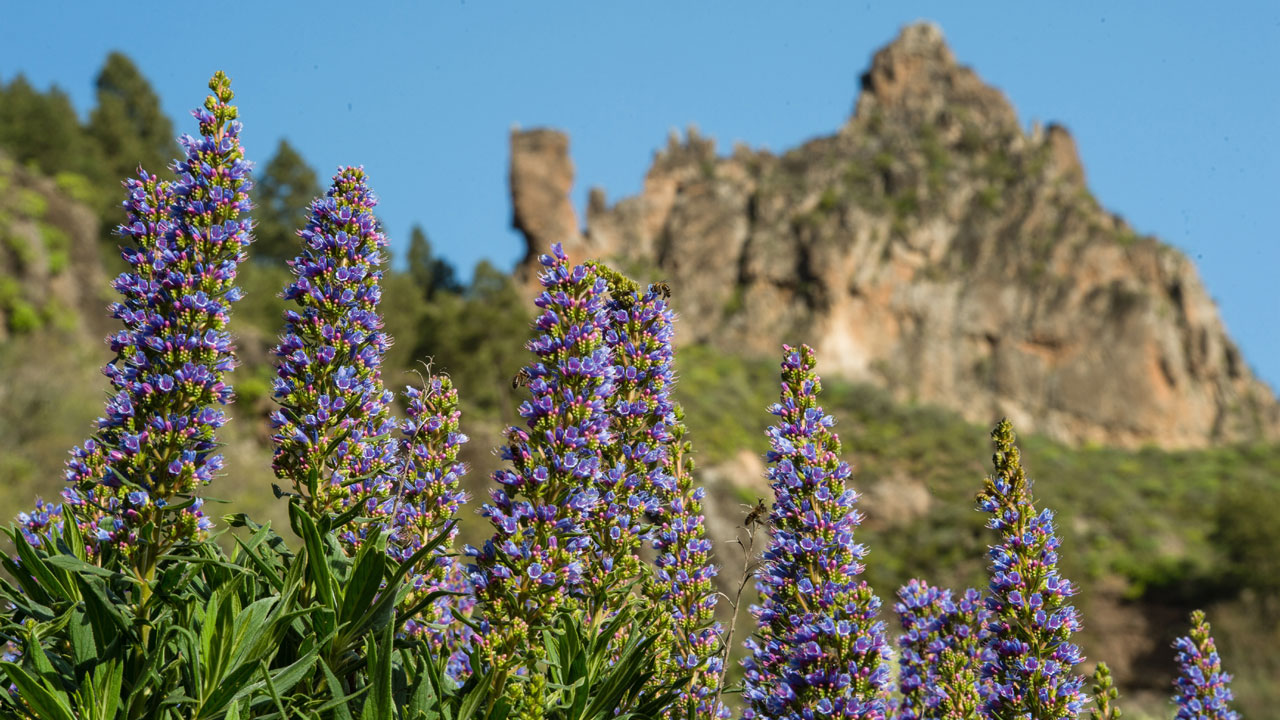
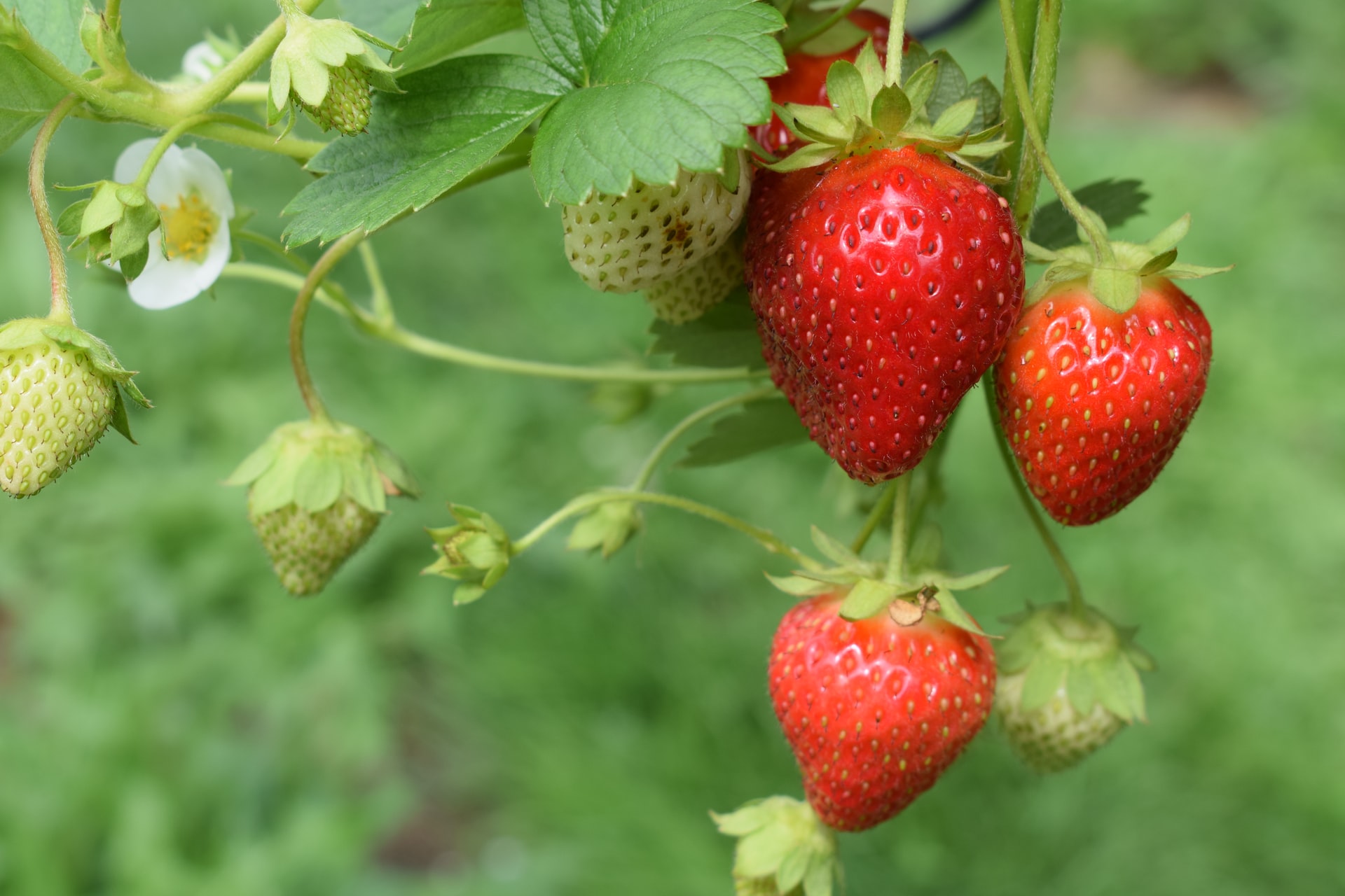
Today, this route has been adapted for hikers and pilgrims. Thus, among pine forests and endemic plants such as tajinastes and verodes, this hiking trail crosses places of high biological value such as Degollada de Becerra, El Garañón, Paso de la Plata and Tunte.
Of course, it’s advisable not to forget sun protection and to bring appropriate footwear, as well as food and drink to enjoy moments of rest along the way.
Itinerary of the La Plata Hiking Route in Gran Canaria
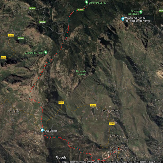
The itinerary of this hiking route in the heights of Gran Canaria begins at the popular campsite located in Llano del Garañón, at the foot of Pico de las Nieves (the highest point of the island at 1,949 metres above sea level).
The route then crosses the GC-600 road (Ayacata-Los Llanos) and continues parallel to it through a pine forest that gradually opens up as it descends towards the Llano and Cortijo de Pargana.
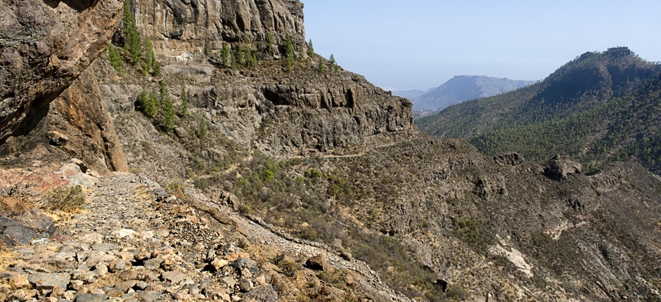
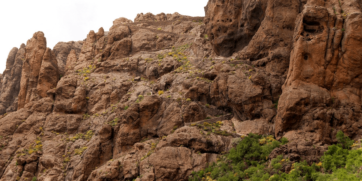
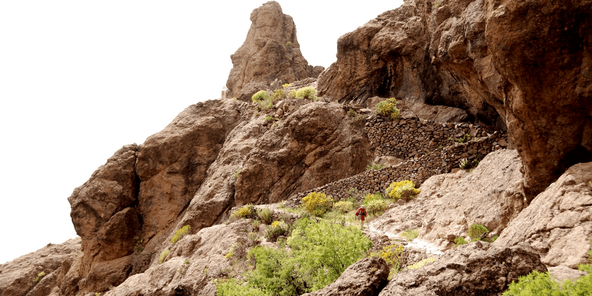
On reaching the Paso de la Plata, between the impressive rocky outcrop of El Puntón and the cliff of Las Carapachas, the eyes cannot believe the spectacle unfolding before them: a cobbled path that winds its way hugging the rock, dodging the sinuous abyss that winds its way towards the Degollada de la Cruz Grande, just where the paths from the southeast meet those from the southwest. If you have vertigo, you probably won't have a good time...
The spectacle is immense, as the arid, rugged and wild south of Gran Canaria meets the humid, lush and magical north of the island. Thus, it’s no surprise that this island is known as the miniature continent.
At the cut-off point (kilometre 6 of the route), after crossing the road, we follow the path towards Tunte through a pine forest that decorates the slopes of the Montaña de la Cruz Grande.
Crossing the Barranquillo del Agua and the Cañada Honda, before passing the Toscas Blancas, the village of Tunte appears in front of us, which is reached via the San Antonio neighbourhood. The end is at the church, home to the image of Saint James at an altitude of about 900 metres.
La Plata Hiking Route in Gran Canaria Technical Data
array(7) { [0]=> array(31) { ["num"]=> string(3) "364" ["createdDate"]=> string(19) "2021-04-06 10:28:09" ["createdByUserNum"]=> string(2) "68" ["updatedDate"]=> string(19) "2023-04-12 14:55:14" ["updatedByUserNum"]=> string(3) "514" ["dragSortOrder"]=> string(2) "44" ["enlace"]=> string(60) "/experiences/barranco-de-los-cernicalos-ravine-hiking-route/" ["title"]=> string(51) "Los Cernícalos Ravine Hiking Route in Gran Canaria" ["content"]=> string(9821) "<p style="text-align:justify;">Los Cernícalos Ravine hiking route is one of the most spectacular experiences of the island. Therefore, it is not surprising that it is visited by countless hikers, amateurs and pros alike, looking to enjoy <a href="https://villagrancanaria.com/blog/hiking-gran-canaria/"><strong>hiking in Gran Canaria</strong></a> in all its glory.</p><p style="text-align:justify;"> </p><p style="text-align:justify;">And one of the wonders of this ravine are its magnificent waterfalls through which water flows non-stop throughout the year. Hopefully it will be a rainy year that will help the stream to continue having the strength and splendor of a lifetime!</p><h2 class="text-3xl m-0 mb-3">Hiking itinerary in the Barranco de los Cernícalos ravine</h2><figure class="image w-full max-w-full flex flex-wrap justify-center mx-auto"><img class="w-full" src="https://villagrancanaria.com/cms/uploads/Merenderos_Barranco_de_los_Cernicalos_1.jpeg"></figure><p style="text-align:justify;">Hiking through the Barranco de los Cernícalos is very easy and fun. In fact, it is a fortunate area because there is always water flowing and its vegetation remains green and lush.</p><p style="text-align:justify;"> </p><p style="text-align:justify;">It is perfect for hiking with children and show them the natural wonders of Gran Canaria. It is, without a doubt, a special occasion for them to learn to take care of it while they explore.</p><p style="text-align:justify;"> </p><p style="text-align:justify;">The trail is a round trip along the same route and runs along the medium-high bed of the ravine. The outward path is almost 7 kilometres, so the total is about 14 kilometres with a low level of difficulty.</p><p style="text-align:justify;"> </p><p style="text-align:justify;">Here you can find one of the largest Canary willow forests in the archipelago. In addition, more than half of the <a href="https://villagrancanaria.com/blog/canary-islands-plants/"><strong>Canary Islands plants</strong></a> that live here is endemic, 10% of it being exclusive to Gran Canaria.</p><p style="text-align:justify;"> </p><p style="text-align:justify;"><strong>IMPORTANT:</strong> some people may not be able to reach the last waterfall, as the path can be difficult. However, the most beautiful point of the route, the great waterfall, is located only about 3 kilometres from the start.</p><h2 class="text-3xl m-0 mb-3">How to get to Los Cernícalos ravine in Gran Canaria</h2><figure class="image w-full max-w-full flex flex-wrap justify-center mx-auto"><img class="w-full" src="https://villagrancanaria.com/cms/uploads/Como_llegar_al_Barranco_de_los_Cernicalos_1.jpeg"></figure><p style="text-align:justify;">The bed of this ravine is located both in the Los Marteles Special Natural Reserve (Valsequillo) and in the Lomo Magullo Protected Landscape (Telde), so technically the ravine runs through part of these municipalities.</p><p style="text-align:justify;"> </p><p style="text-align:justify;">To get there, the easiest way is to enter in any GPS or Google Maps <i>Merenderos Barranco de los Cernícalos</i>, which will take us to an area with tables and benches where we can leave the car before the start of the trail.</p><p style="text-align:justify;"> </p><p style="text-align:justify;">From Las Palmas de Gran Canaria the journey by car to the starting point is about 26 kilometres or 34 minutes, while if you come from the south (for example, Maspalomas) the journey is about 50 kilometres or about 45 minutes.</p><p style="text-align:justify;"> </p><p style="text-align:justify;">You have to cross the city of Telde (the second most populated of the island) from east to west and take the detour to the left leaving behind the towns of Valle de los Nueve, Lomo Magullo and Los Arenales until you reach the picnic areas.</p><h2 class="text-3xl m-0 mb-3">When to hike in the Barranco de los Cernícalos ravine</h2><figure class="image w-full max-w-full flex flex-wrap justify-center mx-auto"><img class="w-full" src="https://villagrancanaria.com/cms/uploads/Senderismo_por_el_Barranco_de_los_Cernicalos_1.jpeg"></figure><p style="text-align:justify;">To make the most of this impressive tour, it is advisable to take into account the following.</p><h3 class="text-2xl m-0 mb-3">Avoid going on weekends or holidays</h3><p style="text-align:justify;">Although the area has a capacity of up to 16 well-parked cars, on holidays or weekends there are usually more visitors. Thus, both the number of walkers and vehicles multiplies making the area a chaos.</p><p style="text-align:justify;"> </p><p style="text-align:justify;">Not only this, but the more people there are, the less space to walk quietly and the more noise there is, whether from people shouting, listening to music, whistling, etc.</p><h3 class="text-2xl m-0 mb-3">Go early in the morning</h3><p style="text-align:justify;">In case you can’t go during the week, the ideal is to start the route early in the morning. The sensation of walking through the ravine accompanied by the whistling of birds and the murmur of rushing water is an unparalleled experience.</p><h2 class="text-3xl m-0 mb-3">The weather in the Barranco de los Cernícalos ravine</h2><figure class="image w-full max-w-full flex flex-wrap justify-center mx-auto"><img class="w-full" src="https://villagrancanaria.com/cms/uploads/El_tiempo_en_el_Barranco_de_los_Cernicalos_1.jpeg"></figure><p style="text-align:justify;">The temperature in Gran Canaria is pleasant throughout the year thanks to the influence of the trade winds blowing from the north, which cool the atmosphere in summer and soften it in winter.</p><p style="text-align:justify;"> </p><p style="text-align:justify;">Be that as it may, it is always advisable to bring something warm if the hiking route through this ravine is done in the winter season or on rainy days, logically.</p><h2 class="text-3xl m-0 mb-3">Technical data of the Barranco de los Cernícalos hiking trail</h2><div class="raw-html-embed"><center><iframe frameborder="0" scrolling="no" src="https://es.wikiloc.com/wikiloc/spatialArtifacts.do?event=view&id=60618762&measures=off&title=on&near=off&images=off&maptype=H" width="500" height="400"></iframe><div style="color:#777;font-size:11px;line-height:16px;">Powered by <a style="color:#06d;font-size:11px;line-height:16px;" target="_blank" rel="noopener" href="https://es.wikiloc.com">Wikiloc</a></div></center></div><p style="text-align:justify;">Although 90% of the route is flat and has no major dangers, it does not mean that you don’t have to pay attention. Indeed, there are some climbs and gorge areas where you will have to hold on to rocks or branches.</p><p style="text-align:justify;"> </p><ul class='bullet'><li class="relative ml-5 list-disc" style="text-align:justify;"><strong>Difficulty:</strong> low</li><li class="relative ml-5 list-disc" style="text-align:justify;"><strong>Distance:</strong> 7 kilometres</li><li class="relative ml-5 list-disc" style="text-align:justify;"><strong>Duration:</strong> 3 hours and 30 minutes</li><li class="relative ml-5 list-disc" style="text-align:justify;"><strong>Circular:</strong> no</li><li class="relative ml-5 list-disc" style="text-align:justify;"><strong>Picnic area:</strong> yes</li></ul><p style="text-align:justify;">Of course, it is advisable to wear appropriate footwear, especially because there may be wet areas where there is a risk of slipping. In addition, it goes without saying that any garbage generated must be collected and left in the appropriate containers.</p><h2 class="text-3xl m-0 mb-3" style="margin-left:0px;text-align:justify;"><span style="background-color:transparent;">Where to stay to enjoy Barranco de los Cernícalos</span></h2><p style="margin-left:0px;text-align:justify;"><span style="background-color:transparent;">Choose the best accommodation where you can stay to enjoy the Barranco de los Cernícalos in all its splendour at </span><a href="https://villagrancanaria.com/canary-islands/?num_people=2&zones=51%2C73%2C52%2C60"><span style="background-color:transparent;"><strong><u>VillaGranCanaria</u></strong></span></a><span style="background-color:transparent;">. If you are looking for privacy and tranquillity on your next holiday, then you need a </span><a href="https://villagrancanaria.com/gran-canaria/country-houses/" target="_blank" rel="noopener" rel="noopener noreferrer"><span style="background-color:transparent;"><strong>country house</strong></span></a><span style="background-color:transparent;">. Imagine waking up every morning surrounded by nature and its sounds, as well as having the opportunity to explore the beautiful landscapes of the island.</span></p><p style="margin-left:0px;text-align:justify;"> </p><p style="margin-left:0px;text-align:justify;"><span style="background-color:transparent;">Take a look at the available options we have on our website at the best prices on the market. We’re waiting for you!</span></p><h2 class="text-3xl m-0 mb-3">Sources on the Barranco de los Cernícalos ravine</h2><ul class='bullet'><li class="relative ml-5 list-disc" style="text-align:justify;"><a href="https://www.grancanaria.com/blog/en/article/los-cernicalos-walk-along-with-water/"><strong>Gran Canaria Tourism Board</strong></a></li><li class="relative ml-5 list-disc" style="text-align:justify;"><a href="https://www.senderismograncanaria.com/barranco-de-los-cernicalos-como-llegar-sin-equivocarse/"><strong>Senderismo Gran Canaria</strong></a></li><li class="relative ml-5 list-disc" style="text-align:justify;"><a href="https://es.wikiloc.com/rutas-senderismo/barranco-de-los-cernicalos-gran-canaria-60618762"><strong>Wikiloc</strong></a></li></ul>" ["titulo_de_pagina"]=> string(65) "Barranco de los Cernícalos Ravine 【ROUTE】 - VillaGranCanaria" ["metatag_descripcion"]=> string(141) "Discover here ⬆️ everything about the Barranco de los Cernícalos ravine hiking route. ✅ This walk in Gran Canaria even has waterfalls!" ["experience_type"]=> string(1) "1" ["short_description"]=> string(89) "Did you know that there are waterfalls between Valsequillo and Telde? Discover them here!" ["city"]=> string(3) "100" ["related_experiences"]=> string(21) " 358 357 346 345 344 " ["visible"]=> string(1) "1" ["draft"]=> string(1) "0" ["admin_only_section"]=> string(1) "0" ["autosaved"]=> string(1) "0" ["builder"]=> string(0) "" ["controlador"]=> string(0) "" ["precontrolador"]=> string(0) "" ["tableName"]=> string(11) "experiences" ["image"]=> array(1) { [0]=> array(12) { ["num"]=> string(5) "59754" ["tableName"]=> string(11) "experiences" ["fieldName"]=> string(5) "image" ["recordNum"]=> string(3) "364" ["filePath"]=> string(89) "/var/www/vhosts/villagrancanaria.com/httpdocs/cms/uploads/Barranco_de_los_Cernicalos.jpeg" ["urlPath"]=> string(44) "/cms/uploads/Barranco_de_los_Cernicalos.jpeg" ["info1"]=> string(0) "" ["info2"]=> string(0) "" ["info3"]=> string(0) "" ["info4"]=> string(0) "" ["info5"]=> string(0) "" ["alt"]=> string(26) "barranco de los cernicalos" } } ["main_image"]=> array(0) { } ["gallery"]=> array(0) { } ["experience_type_bd"]=> array(1) { [0]=> array(17) { ["num"]=> string(1) "1" ["createdDate"]=> string(19) "2020-01-30 15:20:13" ["createdByUserNum"]=> string(3) "102" ["updatedDate"]=> string(19) "2022-03-29 09:40:29" ["updatedByUserNum"]=> string(3) "514" ["dragSortOrder"]=> string(1) "2" ["enlace"]=> string(20) "/experiences/hiking/" ["name"]=> string(6) "Hiking" ["titulo_de_pagina"]=> string(27) "Hiking - Villa Gran Canaria" ["metatag_descripcion"]=> string(136) "The Canary Islands have a spectacular orography with a multitude of hiking routes that amaze all the hikers who come to the archipelago." ["visible"]=> string(1) "1" ["tableName"]=> string(16) "experience_types" ["image"]=> array(1) { [0]=> array(12) { ["num"]=> string(3) "966" ["tableName"]=> string(16) "experience_types" ["fieldName"]=> string(5) "image" ["recordNum"]=> string(1) "1" ["filePath"]=> string(84) "/var/www/vhosts/villagrancanaria.plandeweb.com/httpdocs/cms/uploads/experience_1.png" ["urlPath"]=> string(29) "/cms/uploads/experience_1.png" ["info1"]=> string(10) "Senderismo" ["info2"]=> string(0) "" ["info3"]=> string(0) "" ["info4"]=> string(0) "" ["info5"]=> string(0) "" ["alt"]=> string(0) "" } } ["icon"]=> array(1) { [0]=> array(12) { ["num"]=> string(4) "1061" ["tableName"]=> string(16) "experience_types" ["fieldName"]=> string(4) "icon" ["recordNum"]=> string(1) "1" ["filePath"]=> string(84) "/var/www/vhosts/villagrancanaria.plandeweb.com/httpdocs/cms/uploads/walk_of_fame.png" ["urlPath"]=> string(29) "/cms/uploads/walk_of_fame.png" ["info1"]=> string(0) "" ["info2"]=> string(0) "" ["info3"]=> string(0) "" ["info4"]=> string(0) "" ["info5"]=> string(0) "" ["alt"]=> string(0) "" } } ["banner_images"]=> array(2) { [0]=> array(12) { ["num"]=> string(4) "1048" ["tableName"]=> string(16) "experience_types" ["fieldName"]=> string(13) "banner_images" ["recordNum"]=> string(1) "1" ["filePath"]=> string(105) "/var/www/vhosts/villagrancanaria.plandeweb.com/httpdocs/cms/uploads/jon_flobrant__r19nfvS3wY_unsplash.jpg" ["urlPath"]=> string(50) "/cms/uploads/jon_flobrant__r19nfvS3wY_unsplash.jpg" ["info1"]=> string(0) "" ["info2"]=> string(0) "" ["info3"]=> string(0) "" ["info4"]=> string(0) "" ["info5"]=> string(0) "" ["alt"]=> string(0) "" } [1]=> array(12) { ["num"]=> string(4) "1049" ["tableName"]=> string(16) "experience_types" ["fieldName"]=> string(13) "banner_images" ["recordNum"]=> string(1) "1" ["filePath"]=> string(106) "/var/www/vhosts/villagrancanaria.plandeweb.com/httpdocs/cms/uploads/toomas_tartes_Yizrl9N_eDA_unsplash.jpg" ["urlPath"]=> string(51) "/cms/uploads/toomas_tartes_Yizrl9N_eDA_unsplash.jpg" ["info1"]=> string(0) "" ["info2"]=> string(0) "" ["info3"]=> string(0) "" ["info4"]=> string(0) "" ["info5"]=> string(0) "" ["alt"]=> string(0) "" } } ["breadcrumbField"]=> string(0) "" ["mainFieldBreadcrumb"]=> string(6) "Hiking" } } ["city_bd"]=> array(1) { [0]=> array(38) { ["num"]=> string(1) "1" ["createdDate"]=> string(19) "2020-09-10 16:08:18" ["createdByUserNum"]=> string(1) "1" ["updatedDate"]=> string(19) "2023-12-22 16:11:47" ["updatedByUserNum"]=> string(1) "1" ["dragSortOrder"]=> string(10) "1703261507" ["name"]=> string(12) "Gran Canaria" ["booki_id"]=> string(3) "100" ["booki_name"]=> string(12) "GRAN CANARIA" ["booki_active"]=> string(1) "1" ["enlace"]=> string(14) "/gran-canaria/" ["description"]=> string(249) "Gran Canaria is a miniature continent where you'll find lots of special things to do. Sail out to watch whales, walk in the Canary pine forests, have fun at a water park, wander its shopping streets, visit museums or just relax on a beautiful beach." ["visible"]=> string(1) "1" ["visible_experiencias"]=> string(1) "1" ["booki_exists"]=> string(1) "1" ["titulo_de_pagina"]=> string(50) "Holiday Rentals in Gran Canaria | VillaGranCanaria" ["metatag_descripcion"]=> string(132) "Find and book Holiday Rentals in Gran Canaria at the best price. Apartments, houses, villas, bungalows... Enjoy a unique experience." ["h1"]=> string(36) "Book Holiday Rentals in Gran Canaria" ["content"]=> string(21014) "<h2 class="text-3xl m-0 mb-3">Gran Canaria Holiday Rentals</h2><p>Gran Canaria offers a wide range of activities and attractions for visitors to enjoy. One of the main draws of the island is its <strong>stunning beaches</strong>. From the bustling Playa del Inglés to the more secluded Maspalomas, there are plenty of options to relax, sunbathe, and swim in the crystal-clear waters of the Atlantic Ocean. Water sports enthusiasts can also indulge in activities like surfing, windsurfing, and diving in popular spots such as Las Canteras and Puerto de Mogán.</p><p> </p><p>Aside from its beautiful coastline, Gran Canaria is renowned for its diverse landscapes. The island is home to stunning natural wonders like the dramatic cliffs of Puerto de Mogán, the rugged mountains of Roque Nublo, and the lush forests of Doramas Rural Park. Hiking and biking trails are abundant, allowing visitors to explore the island's unique flora and fauna.</p><p> </p><p><strong>Culture and history</strong> enthusiasts will be fascinated by Gran Canaria's rich heritage. The capital city of Las Palmas de Gran Canaria boasts historical sites like the grand <strong>Cathedral of Santa Ana</strong> and the <i><strong>Casa de Colón</strong></i>, a museum dedicated to Christopher Columbus. The picturesque towns of Teror and Arucas are also worth a visit, with their charming colonial architecture and scenic plazas.</p><p> </p><p>For those seeking <strong>entertainment and nightlife</strong>, Gran Canaria doesn't disappoint. The island is famous for its vibrant nightlife scene, particularly in popular areas like Playa del Inglés and Puerto Rico. Visitors can enjoy a variety of bars, clubs, and live music venues, ensuring there is always something happening after the sun goes down.</p><p> </p><p>In summary, Gran Canaria offers a diverse range of activities and sights to satisfy all types of travelers. From its stunning beaches to its picturesque landscapes and rich cultural heritage, there is something for everyone to enjoy on this beautiful island.</p><p> </p><h2 class="text-3xl m-0 mb-3">The weather in Gran Canaria</h2><p style="text-align:justify;">Did you know that the days in Gran Canaria are long and sunny with mild temperatures and few variations? In fact, Gran Canaria is one of the regions in Europe with <strong>more hours of sunlight</strong> – over 3,000.</p><p style="text-align:justify;"> </p><p style="text-align:justify;">Its geographical location also favours long days that are full of sunlight all year round. In winter, the sun rises at 7:30am and sets at 6:30pm; in summer it’s sunrise at 7:00am and sunset at 8:30pm.</p><p style="text-align:justify;"> </p><h2 class="text-3xl m-0 mb-3">Accommodation options in Gran Canaria</h2><p style="text-align:justify;">Have you already decided that you want to spend your next holiday on the beautiful island of Gran Canaria and you need a holiday rental? Gran Canaria is an island with a huge offer of accommodation of all kinds and for all tastes.</p><p style="text-align:justify;"> </p><h3 class="text-2xl m-0 mb-3">Villas</h3><p style="text-align:justify;">A villa is probably the best option for those looking for maximum privacy. At VillaGranCanaria we are experts in renting villas of all types:</p><p style="text-align:justify;"> </p><ul class='bullet'><li class="relative ml-5 list-disc" style="text-align:justify;"><strong>Villas with private pool:</strong> the best option to enjoy a good bath without sharing space with other people.</li><li class="relative ml-5 list-disc" style="text-align:justify;"><strong>Luxury villas:</strong> if you are looking to treat yourself, the best is a deluxe villa with all kinds of comforts and magnificent views.</li><li class="relative ml-5 list-disc" style="text-align:justify;"><strong>Beach villas:</strong> look no further if you want to wake up to the gentle sea breeze or be mesmerised by the coastal sunsets.</li><li class="relative ml-5 list-disc" style="text-align:justify;"><strong>Cheap villas:</strong> the best high quality accommodation at an affordable price and with the greatest possible comfort.</li><li class="relative ml-5 list-disc" style="text-align:justify;"><strong>Group villas:</strong> the ultimate choice for families with children or groups of friends looking for peace and quiet and a higher degree of privacy.</li></ul><p style="text-align:justify;"> </p><h3 class="text-2xl m-0 mb-3">Apartments</h3><p style="text-align:justify;">Those who prefer to stay in a holiday flat are generally looking to spend more time outside than inside. Even so, at VillaGranCanaria we have great alternatives:</p><p style="text-align:justify;"> </p><ul class='bullet'><li class="relative ml-5 list-disc" style="text-align:justify;"><strong>Beach apartments:</strong> a flat just a few metres from the sea is the best choice for ocean addicts.</li><li class="relative ml-5 list-disc" style="text-align:justify;"><strong>City apartments:</strong> urbanites are in luck because an urban flat is the best way to discover the city's corners.</li><li class="relative ml-5 list-disc" style="text-align:justify;"><strong>Luxury apartments:</strong> if you prefer to live large, a deluxe flat is the perfect option for you.</li><li class="relative ml-5 list-disc" style="text-align:justify;"><strong>Cheap apartments:</strong> if you prefer a cheap flat with the best value for money on the market... stop looking!</li></ul><p style="text-align:justify;"> </p><h3 class="text-2xl m-0 mb-3">Bungalows</h3><p style="text-align:justify;">One of the most popular options on the market are bungalows. Fortunately, at VillaGranCanaria we have the best bungalows on the island at your disposal:</p><p style="text-align:justify;"> </p><ul class='bullet'><li class="relative ml-5 list-disc" style="text-align:justify;"><strong>Beach bungalows:</strong> Imagine spending a day on the sand and just a few steps from your bungalow... The best possible location!</li><li class="relative ml-5 list-disc" style="text-align:justify;"><strong>Luxury bungalows:</strong> a deluxe bungalow is a great option to enjoy the highest comfort in a unique accommodation.</li><li class="relative ml-5 list-disc" style="text-align:justify;"><strong>Cheap bungalows:</strong> the budget bungalows are ideal for sharing, always keeping in mind the best value for money.</li><li class="relative ml-5 list-disc" style="text-align:justify;"><strong>Bungalows with private pool:</strong> if you prefer not to leave the bungalow and enjoy the pool without "neighbours"... This is your option!</li></ul><p style="text-align:justify;"> </p><h3 class="text-2xl m-0 mb-3">Country houses</h3><p style="text-align:justify;">Nature lovers are in luck because this island has spectacular natural landscapes. Discover them by staying in the rural houses of VillaGranCanaria:</p><p style="text-align:justify;"> </p><ul class='bullet'><li class="relative ml-5 list-disc" style="text-align:justify;"><strong>Luxury country houses:</strong> the ideal option to enjoy nature to the maximum with the best comforts in a unique accommodation with incredible views.</li><li class="relative ml-5 list-disc" style="text-align:justify;"><strong>Family country houses:</strong> the alternative for families who want to enjoy the interior of Gran Canaria doing activities with their children.</li></ul><p style="text-align:justify;"> </p><h2 class="text-3xl m-0 mb-3">Travel information for your holiday rentals on Gran Canaria</h2><p style="text-align:justify;">If you're thinking of a holiday rental in Gran Canaria, mark your calendar because this beautiful island is more than just sun, beach and spectacular scenery. Not for nothing is it known as the miniature continent.</p><p style="text-align:justify;"> </p><h3 class="text-2xl m-0 mb-3">Southern Gran Canaria: idyllic beaches surrounded by tradition</h3><p style="text-align:justify;">Being one of the most important tourist destinations in Spain, it is not surprising that most of the tourists who decide to book their holidays in Gran Canaria do so attracted by its dream beaches. And the closest places to enjoy the island's coastline to the full are Salobre Golf, Maspalomas, Meloneras or Pasito Blanco, among others.</p><p style="text-align:justify;"> </p><h3 class="text-2xl m-0 mb-3">Northern Gran Canaria: extraordinary landscapes of cliffs and volcanoes</h3><p style="text-align:justify;">However, more and more people are visiting this destination for rural tourism, hiking, water sports or cycling, and to discover fascinating places such as Roque Nublo, Roque Bentayga or Pico de las Nieves. Be sure to discover charming villages such as Tejeda, San Mateo, Teror, Arucas, Gáldar and Agaete, among others.</p><p style="text-align:justify;"> </p><h3 class="text-2xl m-0 mb-3">Las Palmas de Gran Canaria: the best cultural, commercial and leisure offer on the island</h3><p style="text-align:justify;">The island's capital, a cosmopolitan city open to the sea, is Gran Canaria's main cultural, commercial and leisure attraction. Here you will find everything: shopping centres, museums, restaurants, the kilometre-long and impressive Las Canteras beach, the majestic Alfredo Kraus Auditorium, the historic Cathedral of Santa Ana... the list goes on and on!</p><p style="text-align:justify;"> </p><h2 class="text-3xl m-0 mb-3">How to get to your holiday rental in Gran Canaria</h2><p style="text-align:justify;">The best way to travel to Gran Canaria is by air to the Gran Canaria Airport (LPA), which is located around the middle of the east coast of the island. It is situated more or less at the same distance (about 25 kilometres) from the capital, Las Palmas de Gran Canaria, and the southern part, a true sunny paradise.</p><p style="text-align:justify;"> </p><p style="text-align:justify;">No matter the location of your Gran Canaria holiday home, it will likely be accessible by transportation from the airport. Buses, coaches and taxis are all available for you to bring you to your destination. Rental cars are also available at the airport, which ensure a quicker and more comfortable journey.</p><p style="text-align:justify;"> </p><h2 class="text-3xl m-0 mb-3">Gran Canaria and its gastronomy</h2><p style="text-align:justify;">The local cuisine of the Canary Islands comprises a variety of fresh vegetables and a mix of seafood and meat. This gastronomy is influenced by many cultures, most prevalently Spanish, North African, Latin American and even historical aboriginal themes also influence the vibrant local dishes.</p><p style="text-align:justify;"> </p><p style="text-align:justify;">We encourage you to choose from the large variety of traditional restaurants called bochinches or guachinches throughout the island if a true Canarian culinary experience is what you are after. Nevertheless, there are plenty of restaurants where international gastronomy can be found.</p><p style="text-align:justify;"> </p><h2 class="text-3xl m-0 mb-3">What to do in Gran Canaria with children</h2><p style="text-align:justify;">For a different and fun family holiday, there is nothing better than a visit to Gran Canaria. The island has everything the little ones need to have a great time: water parks, theme parks, amusement parks, outdoor activities, zoos, aquariums and the chance to live unforgettable experiences and adventures in places where fun for young and old is always guaranteed.</p><p style="text-align:justify;"> </p><h3 class="text-2xl m-0 mb-3">Water parks</h3><p style="text-align:justify;">Although all the water parks are ideal for having a great time, spending a day at Aqualand Maspalomas or Lago Taurito (100% salt water) is an unforgettable experience not to be missed if you are travelling to Gran Canaria with children.</p><p style="text-align:justify;"> </p><h3 class="text-2xl m-0 mb-3">Theme parks</h3><p style="text-align:justify;">Children always have a great time at theme parks. It's a safe bet. And in Gran Canaria there are two of the best: Sioux City Park (where they will feel like a western sheriff) and GrancAventura (a different adventure park...).</p><p style="text-align:justify;"> </p><h3 class="text-2xl m-0 mb-3">Amusement parks</h3><p style="text-align:justify;">The classic amusement parks are also a great attraction for children. Here you will find two spectacular ones: Angry Birds Activity Park (for action-packed fun) and Holidayworld Maspalomas (with countless attractions, bowling, escape room, karaoke...).</p><p style="text-align:justify;"> </p><h3 class="text-2xl m-0 mb-3">Zoos and aquariums</h3><p style="text-align:justify;">Gran Canaria also has zoos and aquariums where you can discover all kinds of exotic animals up close: Palmitos Park (with a large number of birds, plants, reptiles, mammals...) and Poema del Mar (with three well-differentiated areas and thousands of marine species).</p><p style="text-align:justify;"> </p><h2 class="text-3xl m-0 mb-3">Practising sports in Gran Canaria</h2><p style="text-align:justify;">Gran Canaria is famous for its magnificent beaches of fine sand and crystal-clear waters, but also offers much more than sun and sand. Its lush forests, mountains, trails, ravines, beaches, reefs and clean skies are some of the natural spaces in Gran Canaria that invite you to do active tourism, without forgetting relaxation, fun and adventure. Some of the most practiced sports on the island are:</p><p style="text-align:justify;"> </p><h3 class="text-2xl m-0 mb-3">Golf</h3><p style="text-align:justify;">Gran Canaria provides fully equipped infrastructures and top-class courses adapted for all handicaps designed by world champions and reputed architects like Salobre Golf. The climate here means you can enjoy golf all year round to focus on your game and disconnect from it all. And after a few swings, there’s practically no better plan than to spend a while relaxing on the beach, for professionals and amateurs alike.</p><p style="text-align:justify;"> </p><h3 class="text-2xl m-0 mb-3">Cycling</h3><p style="text-align:justify;">Gran Canaria has a huge variety of ideal routes for road cycling, with paved tracks and roads with slopes and gradients that cross volcanic passes posing a great challenge for cyclists of all levels. The unchanging temperatures throughout the year and the low rainfall enable you to go cycling every day of the year.</p><p style="text-align:justify;"> </p><h3 class="text-2xl m-0 mb-3">Water sports</h3><p style="text-align:justify;">The sea around the island allows for many water sports to be practiced, like the following ones:</p><p style="text-align:justify;"> </p><ul class='bullet'><li class="relative ml-5 list-disc" style="text-align:justify;">Surfing</li><li class="relative ml-5 list-disc" style="text-align:justify;">Windsurfing</li><li class="relative ml-5 list-disc" style="text-align:justify;">Kitesurfing</li><li class="relative ml-5 list-disc" style="text-align:justify;">Bodyboarding</li><li class="relative ml-5 list-disc" style="text-align:justify;">Stand up paddle</li><li class="relative ml-5 list-disc" style="text-align:justify;">Scuba diving</li><li class="relative ml-5 list-disc" style="text-align:justify;">Snorkeling</li><li class="relative ml-5 list-disc" style="text-align:justify;">Sailing</li><li class="relative ml-5 list-disc" style="text-align:justify;">Parasailing</li><li class="relative ml-5 list-disc" style="text-align:justify;">Kayaking</li><li class="relative ml-5 list-disc" style="text-align:justify;">Fishing</li><li class="relative ml-5 list-disc" style="text-align:justify;">Jet skiing</li></ul><p style="text-align:justify;"> </p><h3 class="text-2xl m-0 mb-3">Mountain sports</h3><p style="text-align:justify;">Of course, apart from sea sports there are lots of mountain sports you can do on the island:</p><p style="text-align:justify;"> </p><ul class='bullet'><li class="relative ml-5 list-disc" style="text-align:justify;">Hiking</li><li class="relative ml-5 list-disc" style="text-align:justify;">Trail running</li><li class="relative ml-5 list-disc" style="text-align:justify;">Climbing</li><li class="relative ml-5 list-disc" style="text-align:justify;">Mountain biking</li><li class="relative ml-5 list-disc" style="text-align:justify;">Trekking</li><li class="relative ml-5 list-disc" style="text-align:justify;">Orienteering</li><li class="relative ml-5 list-disc" style="text-align:justify;">Canyoning</li><li class="relative ml-5 list-disc" style="text-align:justify;">Paragliding</li></ul><p style="text-align:justify;"> </p><h2 class="text-3xl m-0 mb-3">Museums in Gran Canaria</h2><p style="text-align:justify;">Theatre, dance, concerts and plastic arts go hand in hand in the island's cultural agenda.</p><p style="text-align:justify;"> </p><h3 class="text-2xl m-0 mb-3">1. Museo Néstor</h3><p style="text-align:justify;">In the Museo Néstor, named after the local artist Néstor de la Torre, you can see his portraits and most important works. It is located in the Pueblo Canario, in the capital of Gran Canaria.</p><p style="text-align:justify;"> </p><h3 class="text-2xl m-0 mb-3">2. Casa de Colón</h3><p style="text-align:justify;">The Casa de Colón, located in the Vegueta district of the historic quarter of Las Palmas de Gran Canaria, is the best option for discovering the island's relationship with the American continent and what oceanic voyages were like.</p><p style="text-align:justify;"> </p><h3 class="text-2xl m-0 mb-3">3. CAAM</h3><p style="text-align:justify;">Nearby, the Centro Atlántico de Arte Moderno (CAAM or Atlantic Centre of Modern Art) is the archipelago's leading contemporary art museum. Highly recommended for those looking for a different kind of museum.</p><p style="text-align:justify;"> </p><h3 class="text-2xl m-0 mb-3">4. Museo Canario</h3><p style="text-align:justify;">What were the ancient Canarians like and how did they live? The answer to these and many more questions can be found at the Museo Canario in Las Palmas. Its large collection of aboriginal mummies will leave you speechless.</p><p style="text-align:justify;"> </p><h3 class="text-2xl m-0 mb-3">5. Museo Elder</h3><p style="text-align:justify;">The Elder Museum of Science and Technology has one rule that everyone who enters the museum must obey: it is strictly forbidden not to touch. Young and old alike will have a great time in a 100% interactive museum.</p><p style="text-align:justify;"> </p><h2 class="text-3xl m-0 mb-3">Nightlife in Gran Canaria</h2><p style="text-align:justify;">If nightlife is your thing, Gran Canaria is the place to go, with a vibrant and fun atmosphere throughout the cities on the island. Choose from a range of pubs, bars, clubs and discos, in cities like Las Palmas, Playa del Inglés, Maspalomas and Meloneras.</p><p style="text-align:justify;"> </p><p style="text-align:justify;">In fact, in certain areas the island seems to never sleep, and parties deep into the night. If you are looking for a quieter atmosphere, skip the clubs and check out the numerous stylish bars, cafés and casinos throughout the cities on the island.</p><p style="text-align:justify;"> </p><h2 class="text-3xl m-0 mb-3">What to see in Gran Canaria</h2><p style="text-align:justify;">On an island that offers as much to the visitor as Gran Canaria, you should not miss the most attractive places on the island:</p><p style="text-align:justify;"> </p><h3 class="text-2xl m-0 mb-3">1. Maspalomas Dunes</h3><p style="text-align:justify;">Located on the south coast of the island, the dunes of Maspalomas were formed from ocean sand during the Ice Age and are now a nature reserve.</p><p style="text-align:justify;"> </p><h3 class="text-2xl m-0 mb-3">2. Roque Nublo</h3><p style="text-align:justify;">The Roque Nublo, located in Tejeda and 67 metres high, was formed by a volcanic eruption millions of years ago and was used by the ancient Canarians for rituals.</p><p style="text-align:justify;"> </p><h3 class="text-2xl m-0 mb-3">3. Las Canteras Beach</h3><p style="text-align:justify;">This urban beach is one of the best in Gran Canaria. It is almost 4 kilometres long and is protected by La Barra, a rock formation with abundant marine life.</p><p style="text-align:justify;"> </p><h3 class="text-2xl m-0 mb-3">4. Vegueta</h3><p style="text-align:justify;">With its narrow cobbled streets, this old part of Las Palmas transports visitors back to the 15th century, with beautiful buildings, galleries and museums steeped in history.</p><p style="text-align:justify;"> </p><h3 class="text-2xl m-0 mb-3">5. Puerto de Mogán</h3><p style="text-align:justify;">The canals that link the marina with the fishing port gave the town its name of Little Venice. It is a place to enjoy fresh fish on a daily basis.</p>" ["experiences_heading"]=> string(31) "Top Experiences in Gran Canaria" ["experiences"]=> string(13) " 362 357 308 " ["faq"]=> string(381) "[{"question":"157"},{"question":"158"},{"question":"159"},{"question":"160"},{"question":"161"},{"question":"162"},{"question":"163"},{"question":"164"},{"question":"165"},{"question":"166"},{"question":"167"},{"question":"168"},{"question":"169"},{"question":"170"},{"question":"171"},{"question":"172"},{"question":"173"},{"question":"174"},{"question":"175"},{"question":"176"}]" ["featured_links_heading"]=> string(0) "" ["faq_heading"]=> string(64) "Frequently asked questions about holiday rentals in Gran Canaria" ["featured_links_heading_2"]=> string(0) "" ["admin_only_section"]=> string(1) "0" ["autosaved"]=> string(1) "0" ["builder"]=> string(0) "" ["controlador"]=> string(0) "" ["precontrolador"]=> string(0) "" ["tableName"]=> string(6) "cities" ["image"]=> array(1) { [0]=> array(12) { ["num"]=> string(4) "1025" ["tableName"]=> string(6) "cities" ["fieldName"]=> string(5) "image" ["recordNum"]=> string(1) "1" ["filePath"]=> string(94) "/var/www/vhosts/villagrancanaria.plandeweb.com/httpdocs/cms/uploads/shutterstock_373706371.jpg" ["urlPath"]=> string(39) "/cms/uploads/shutterstock_373706371.jpg" ["info1"]=> string(0) "" ["info2"]=> string(0) "" ["info3"]=> string(0) "" ["info4"]=> string(0) "" ["info5"]=> string(0) "" ["alt"]=> string(28) "holiday rentals gran canaria" } } ["experience_banner_images"]=> array(2) { [0]=> array(12) { ["num"]=> string(4) "1051" ["tableName"]=> string(6) "cities" ["fieldName"]=> string(24) "experience_banner_images" ["recordNum"]=> string(1) "1" ["filePath"]=> string(105) "/var/www/vhosts/villagrancanaria.plandeweb.com/httpdocs/cms/uploads/tom_keighley_9dnY4x0MKVY_unsplash.jpg" ["urlPath"]=> string(50) "/cms/uploads/tom_keighley_9dnY4x0MKVY_unsplash.jpg" ["info1"]=> string(0) "" ["info2"]=> string(0) "" ["info3"]=> string(0) "" ["info4"]=> string(0) "" ["info5"]=> string(0) "" ["alt"]=> string(31) "gran canaria casas vacacionales" } [1]=> array(12) { ["num"]=> string(5) "20146" ["tableName"]=> string(6) "cities" ["fieldName"]=> string(24) "experience_banner_images" ["recordNum"]=> string(1) "1" ["filePath"]=> string(103) "/var/www/vhosts/villagrancanaria.plandeweb.com/httpdocs/cms/uploads//cms/uploads/2018/03/maspalomas.jpg" ["urlPath"]=> string(35) "/cms/uploads/2018/03/maspalomas.jpg" ["info1"]=> string(0) "" ["info2"]=> string(0) "" ["info3"]=> string(0) "" ["info4"]=> string(0) "" ["info5"]=> string(0) "" ["alt"]=> string(23) "vacaciones gran canaria" } } ["featured_links"]=> array(0) { } ["featured_links_2"]=> array(0) { } ["faq_bd"]=> array(20) { [0]=> array(1) { ["question"]=> string(3) "157" } [1]=> array(1) { ["question"]=> string(3) "158" } [2]=> array(1) { ["question"]=> string(3) "159" } [3]=> array(1) { ["question"]=> string(3) "160" } [4]=> array(1) { ["question"]=> string(3) "161" } [5]=> array(1) { ["question"]=> string(3) "162" } [6]=> array(1) { ["question"]=> string(3) "163" } [7]=> array(1) { ["question"]=> string(3) "164" } [8]=> array(1) { ["question"]=> string(3) "165" } [9]=> array(1) { ["question"]=> string(3) "166" } [10]=> array(1) { ["question"]=> string(3) "167" } [11]=> array(1) { ["question"]=> string(3) "168" } [12]=> array(1) { ["question"]=> string(3) "169" } [13]=> array(1) { ["question"]=> string(3) "170" } [14]=> array(1) { ["question"]=> string(3) "171" } [15]=> array(1) { ["question"]=> string(3) "172" } [16]=> array(1) { ["question"]=> string(3) "173" } [17]=> array(1) { ["question"]=> string(3) "174" } [18]=> array(1) { ["question"]=> string(3) "175" } [19]=> array(1) { ["question"]=> string(3) "176" } } ["breadcrumbField"]=> string(0) "" ["mainFieldBreadcrumb"]=> string(12) "Gran Canaria" } } ["related_experiences_bd"]=> array(5) { [0]=> array(28) { ["num"]=> string(3) "358" ["createdDate"]=> string(19) "2021-02-17 15:17:57" ["createdByUserNum"]=> string(2) "68" ["updatedDate"]=> string(19) "2022-04-04 13:02:07" ["updatedByUserNum"]=> string(3) "514" ["dragSortOrder"]=> string(2) "38" ["enlace"]=> string(48) "/experiences/la-plata-hiking-route-gran-canaria/" ["title"]=> string(37) "La Plata Hiking Route in Gran Canaria" ["content"]=> string(6826) "<p style="text-align:justify;">The La Plata hiking route in Gran Canaria (literally, the Silver Route) crosses the beautiful and rugged interior of the island along a path that for a long time served as a means of communication between the southern and northern slopes of the island.</p><p style="text-align:justify;"> </p><p style="text-align:justify;">This route has its origins in the need to transport the large herds of cattle in search of the abundant pastures of the southern lands after the winter rainy season. This transhumance was known as the ‘mudá del ganado’.</p><p style="text-align:justify;"> </p><p style="text-align:justify;">Thus, it’s a route that endured a huge commercial bustle and was also used intensively by the pilgrims who walked the <a target="_blank" rel="noopener" rel="noopener noreferrer" href="https://villagrancanaria.com/experiences/way-saint-james-gran-canaria/"><strong>Way of Saint James in Gran Canaria</strong></a> every July to venerate the Apostle in Tunte.</p><p style="text-align:justify;"> </p><p style="text-align:justify;">It’s undoubtedly one of the most spectacular works of road engineering in the Canary Islands, with a socio-economic importance of incalculable value for the inhabitants of the round island.</p><p style="text-align:justify;"> </p><p style="text-align:justify;">This amazing creation in Gran Canaria, which in the past facilitated the transit of traders, livestock and shepherds, muleteers, beasts of burden, artisans, neighbours and pilgrims, is now travelled by tourists, mountaineers and hikers.</p><h2 class="text-3xl m-0 mb-3">La Plata Hiking Trail Route in Gran Canaria (9,6 km)</h2><figure class="image w-full max-w-full flex flex-wrap justify-center mx-auto"><img class="w-full" src="https://villagrancanaria.com/cms/uploads/Camino_de_la_Plata_en_Gran_Canaria_2.png"></figure><p style="text-align:justify;">This trekking route follows a road used by humans and livestock that the ancient settlers of Gran Canaria used to move their animals in search of the best pastures each season.</p><p style="text-align:justify;"> </p><p style="text-align:justify;">With the improvements paid for out of pocket by a wealthy landowner at the end of the 19th century, the Gran Canarian people were able to avoid the geographical features of the peaks to the south when road communications were non-existent.</p><p style="text-align:justify;"> </p><p style="text-align:justify;">Today, this route has been adapted for hikers and pilgrims. Thus, among pine forests and endemic plants such as tajinastes and verodes, this hiking trail crosses places of high biological value such as Degollada de Becerra, El Garañón, Paso de la Plata and Tunte.</p><p style="text-align:justify;"> </p><p style="text-align:justify;">Of course, it’s advisable not to forget sun protection and to bring appropriate footwear, as well as food and drink to enjoy moments of rest along the way.</p><h2 class="text-3xl m-0 mb-3">Itinerary of the La Plata Hiking Route in Gran Canaria</h2><figure class="image w-full max-w-full flex flex-wrap justify-center mx-auto"><img class="w-full" src="https://villagrancanaria.com/cms/uploads/Itinerario_de_la_ruta_de_la_plata_en_Gran_Canaria_2.png"></figure><p style="text-align:justify;">The itinerary of this hiking route in the heights of Gran Canaria begins at the popular campsite located in Llano del Garañón, at the foot of Pico de las Nieves (the highest point of the island at 1,949 metres above sea level).</p><p style="text-align:justify;"> </p><p style="text-align:justify;">The route then crosses the GC-600 road (Ayacata-Los Llanos) and continues parallel to it through a pine forest that gradually opens up as it descends towards the Llano and Cortijo de Pargana.</p><p style="text-align:justify;"> </p><p style="text-align:justify;">On reaching the Paso de la Plata, between the impressive rocky outcrop of El Puntón and the cliff of Las Carapachas, the eyes cannot believe the spectacle unfolding before them: a cobbled path that winds its way hugging the rock, dodging the sinuous abyss that winds its way towards the Degollada de la Cruz Grande, just where the paths from the southeast meet those from the southwest. If you have vertigo, you probably won't have a good time...</p><p style="text-align:justify;"> </p><p style="text-align:justify;">The spectacle is immense, as the arid, rugged and wild south of Gran Canaria meets the humid, lush and magical north of the island. Thus, it’s no surprise that this island is known as the miniature continent.</p><p style="text-align:justify;"> </p><p style="text-align:justify;">At the cut-off point (kilometre 6 of the route), after crossing the road, we follow the path towards Tunte through a pine forest that decorates the slopes of the Montaña de la Cruz Grande.</p><p style="text-align:justify;"> </p><p style="text-align:justify;">Crossing the Barranquillo del Agua and the Cañada Honda, before passing the Toscas Blancas, the village of Tunte appears in front of us, which is reached via the San Antonio neighbourhood. The end is at the church, home to the image of Saint James at an altitude of about 900 metres.</p><h2 class="text-3xl m-0 mb-3">La Plata Hiking Route in Gran Canaria Technical Data</h2><figure class="image w-full max-w-full flex flex-wrap justify-center mx-auto"><img class="w-full" src="https://villagrancanaria.com/cms/uploads/Paso_de_la_Plata_1.png"></figure><ul class='bullet'><li class="relative ml-5 list-disc" style="text-align:justify;"><strong>Distance:</strong> 9,6 km</li><li class="relative ml-5 list-disc" style="text-align:justify;"><strong>Maximum height:</strong> 1.657 m</li><li class="relative ml-5 list-disc" style="text-align:justify;"><strong>Minimum height:</strong> 892 m</li><li class="relative ml-5 list-disc" style="text-align:justify;"><strong>Difficulty:</strong> medium</li><li class="relative ml-5 list-disc" style="text-align:justify;"><strong>Duration:</strong> 2:30 hours</li></ul><h2 class="text-3xl m-0 mb-3">Sources</h2><ul class='bullet'><li class="relative ml-5 list-disc" style="text-align:justify;"><a target="_blank" rel="noopener" rel="noopener noreferrer" href="https://atlasruraldegrancanaria.com/"><strong>Atlas Rural de Gran Canaria</strong></a></li><li class="relative ml-5 list-disc" style="text-align:justify;"><a target="_blank" rel="noopener" rel="noopener noreferrer" href="https://www.hellocanaryislands.com/hiking/gran-canaria/ruta-de-la-plata/"><strong>Hello Canary Islands</strong></a></li><li class="relative ml-5 list-disc" style="text-align:justify;"><a target="_blank" rel="noopener" rel="noopener noreferrer" href="https://www.revistabinter.com/2018/01/29/ruta-la-plata/"><strong>Revista Binter</strong></a></li></ul>" ["titulo_de_pagina"]=> string(60) "▷ La Plata Hiking Route in Gran Canaria - VillaGranCanaria" ["metatag_descripcion"]=> string(153) "Discover here ⬆️ the La Plata Hiking Route in Gran Canaria. ✅ Do you dare to walk along a historic hiking trail through the interior of the island?" ["experience_type"]=> string(1) "1" ["short_description"]=> string(61) "Enjoy one of the most historic hiking routes in Gran Canaria." ["city"]=> string(3) "100" ["related_experiences"]=> string(29) " 364 357 346 345 344 325 326 " ["visible"]=> string(1) "1" ["draft"]=> string(1) "0" ["admin_only_section"]=> string(1) "0" ["autosaved"]=> string(1) "0" ["builder"]=> string(0) "" ["controlador"]=> string(0) "" ["precontrolador"]=> string(0) "" ["tableName"]=> string(11) "experiences" ["image"]=> array(1) { [0]=> array(12) { ["num"]=> string(5) "59735" ["tableName"]=> string(11) "experiences" ["fieldName"]=> string(5) "image" ["recordNum"]=> string(3) "358" ["filePath"]=> string(94) "/var/www/vhosts/villagrancanaria.com/httpdocs/cms/uploads/Ruta_de_la_Plata_en_Gran_Canaria.jpg" ["urlPath"]=> string(49) "/cms/uploads/Ruta_de_la_Plata_en_Gran_Canaria.jpg" ["info1"]=> string(0) "" ["info2"]=> string(0) "" ["info3"]=> string(0) "" ["info4"]=> string(0) "" ["info5"]=> string(0) "" ["alt"]=> string(26) "ruta la plata gran canaria" } } ["main_image"]=> array(0) { } ["gallery"]=> array(0) { } ["breadcrumbField"]=> string(0) "" ["mainFieldBreadcrumb"]=> string(37) "La Plata Hiking Route in Gran Canaria" } [1]=> array(28) { ["num"]=> string(3) "357" ["createdDate"]=> string(19) "2021-02-09 09:23:59" ["createdByUserNum"]=> string(2) "68" ["updatedDate"]=> string(19) "2023-04-12 15:41:43" ["updatedByUserNum"]=> string(3) "514" ["dragSortOrder"]=> string(2) "37" ["enlace"]=> string(42) "/experiences/way-saint-james-gran-canaria/" ["title"]=> string(38) "The Way of Saint James in Gran Canaria" ["content"]=> string(22713) "<p style="text-align:justify;">The Way of Saint James in Gran Canaria? Yes, you read that right. Believe it or not, this island has its own official hiking route that you can do alone, with your family, with friends or even with strangers in an unforgettable and enriching experience for body and soul.</p><p style="text-align:justify;"> </p><p style="text-align:justify;"><i>Tamarán</i> (as the island was called by the ancient aboriginal settlers) is the only recognised route outside the European continent that takes walkers across Gran Canaria from south to north with an open heart, discovering first-hand why this island is also known as the ‘miniature continent’.</p><p style="text-align:justify;"> </p><p style="text-align:justify;">Doing this Jacobean route is something that happens suddenly at a certain moment without ceremony or solemnity. It is probably an idea that has been orbiting in the back of one's mind and finally materialises into a certainty. However, it is logical that certain doubts arise…</p><p style="text-align:justify;"> </p><p style="text-align:justify;">What now? Do I have to train? How much should I train? What equipment, clothing and footwear should I take? Where to sleep? Where to eat? Is it better to do it individually or in company? Is it a route suitable for beginners or is it aimed at experts? All these questions, and many more, are answered below.</p><h2 class="text-3xl m-0 mb-3">History of the Way of St. James in Gran Canaria 😇</h2><figure class="media"><div data-oembed-url="https://www.youtube.com/watch?v=Q8WVEajNscg"><div style="position: relative; padding-bottom: 100%; height: 0; padding-bottom: 56.2493%;"><iframe src="https://www.youtube.com/embed/Q8WVEajNscg" style="position: absolute; width: 100%; height: 100%; top: 0; left: 0;" frameborder="0" allow="autoplay; encrypted-media" allowfullscreen=""></iframe></div></div></figure><p style="text-align:justify;">The privileged geographical location of the Canary Islands in the middle of the navigation routes between Europe, Africa, Asia and the Americas attracted a multitude of sailors, merchants and soldiers from Castile and other nations since its discovery.</p><p style="text-align:justify;"> </p><p style="text-align:justify;">Thus, legend has it that at the end of the Middle Ages (around the 15th century) a ship whose crew of Galician sailors were very devoted to the apostle Saint James the Great was hit by a sudden storm south of Gran Canaria.</p><p style="text-align:justify;"> </p><p style="text-align:justify;">Once on dry land, and after their prayers saved their lives, they contemplated the high mountains of Tirajana from Arguineguín and promised to take the figure of the saint to the top of the mountains and build a hermitage for his veneration in the future Santiago de Tunte.</p><figure class="image w-full max-w-full flex flex-wrap justify-center mx-auto"><img class="w-full" src="https://villagrancanaria.com/cms/uploads/Apo_stol_Santiago_el_Mayor_1.jpg"></figure><p style="text-align:justify;">Almost at the same time, but in the north of Gran Canaria, the first mass on the island was celebrated in 1481 near the future Gáldar Main Temple and Archpriestly Church of Knights of Saint James, as the town was named by the Castilians.</p><p style="text-align:justify;"> </p><p style="text-align:justify;">Since many people throughout history made pilgrimages from one place to another, in 1965 Pope Paul XVI granted a Papal Bull with the same privileges as the Way of Saint James to Compostela.</p><p style="text-align:justify;"> </p><p style="text-align:justify;">A few years later, His Holiness John Paul II granted this Bull in perpetuity. Thus, those who make the pilgrimage to this northern church can receive three types of indulgence at the end of the route, equivalent to those obtained on arrival at Santiago de Compostela:</p><ul class='bullet'><li class="relative ml-5 list-disc" style="text-align:justify;">That of the ordinary visit during the whole Jubilee year.</li><li class="relative ml-5 list-disc" style="text-align:justify;">The one corresponding to that of the day of the Holy Lord St. James to be earned on 25 July.</li><li class="relative ml-5 list-disc" style="text-align:justify;">The extraordinary one that is earned both on the day of the opening of the Holy Door every 1st January of the Jubilee Year and on the day of the closing of the Holy Door on the last day of the Jubilee Year, 31st December.</li></ul><h2 class="text-3xl m-0 mb-3">Jacobean Route of Gran Canaria🥾</h2><figure class="image w-full max-w-full flex flex-wrap justify-center mx-auto"><img class="w-full" src="https://villagrancanaria.com/cms/uploads/Ruta_Camino_de_Santiago_Gran_Canaria_2.png"></figure><p style="text-align:justify;">The Way of St. James in Gran Canaria is not very well known, even by the inhabitants of the island. Undoubtedly, when talking about the Jacobean itinerary, one usually thinks (and rightly so) of the route that leads to the Galician capital.</p><p style="text-align:justify;"> </p><p style="text-align:justify;">However, even if it is not via the classic French Way, the Northern Way, the Portuguese Way or the Silver Way, it is possible to follow the Way of St. James from Maspalomas to Gáldar along dirt tracks, roads, <a href="https://villagrancanaria.com/blog/royal-paths-gran-canaria/"><strong>royal paths</strong></a> and more.</p><p style="text-align:justify;"> </p><p style="text-align:justify;">Unlike the traditional Way of St. James, this route through Gran Canaria has no official markings or signs, so it is recommended to use a GPS device that works without an internet connection.</p><h3 class="text-2xl m-0 mb-3">Stage 1: Maspalomas ➡️ Tunte (28 km)</h3><figure class="image w-full max-w-full flex flex-wrap justify-center mx-auto"><img class="w-full" src="https://villagrancanaria.com/cms/uploads/Etapa_1_2.png"></figure><p style="text-align:justify;">Although this first stage does not correspond to the Jacobean route of Gran Canaria, it is undoubtedly a great excuse to relive the legend of those heroes from the sea who crossed the island from the south to the highest point of the island.</p><p style="text-align:justify;"> </p><p style="text-align:justify;">It is a long uphill hiking route that starts in Maspalomas and climbs through the Fataga ravine, passing through the village of Arteara, the town of Fataga and ends in Tunte after 28 kilometres of walking.</p><p style="text-align:justify;"> </p><p style="text-align:justify;">The Way of Saint James in Gran Canaria starts at the Maspalomas lighthouse (the southernmost point of Gran Canaria) and heads north. We turn right at the first roundabout and we turn left when we reach the Maspalomas pond.</p><p style="text-align:justify;"> </p><p style="text-align:justify;">We will always follow the hiking route up the Maspalomas ravine, passing the Tony Gallardo Park, the Holidayworld Maspalomas entertainment centre and linking up with the Fataga ravine.</p><p style="text-align:justify;"> </p><p style="text-align:justify;">The long ascent of 17 kilometres will take us to the village of Arteara, where we will be able to contemplate the Arteara Palm Grove. After another 5 kilometres we reach the village of Fataga.</p><p style="text-align:justify;"> </p><p style="text-align:justify;">We continue the route northwards, stopping at the Fataga viewpoint to observe the impressive views of the southern side of Gran Canaria and, after another 6 kilometres, we reach the end of the stage: Tunte.</p><figure class="image w-full max-w-full flex flex-wrap justify-center mx-auto"><img class="w-full" src="https://villagrancanaria.com/cms/uploads/Camino_jacobeo_Gran_Canaria_1.jpg"></figure><p style="text-align:justify;"><strong>TECHNICAL DATA</strong></p><ul class='bullet'><li class="relative ml-5 list-disc" style="text-align:justify;"><strong>Distance:</strong> 28 km</li><li class="relative ml-5 list-disc" style="text-align:justify;"><strong>Difficulty:</strong> high</li><li class="relative ml-5 list-disc" style="text-align:justify;"><strong>Time:</strong> 9 hours</li><li class="relative ml-5 list-disc" style="text-align:justify;"><strong>Slope:</strong> +1,200 m, -340 m</li><li class="relative ml-5 list-disc" style="text-align:justify;"><strong>Maximum height:</strong> 945 metres above sea level</li><li class="relative ml-5 list-disc" style="text-align:justify;"><strong>Surface:</strong> asphalt (28%), dirt (61%), path (11%)</li></ul><h3 class="text-2xl m-0 mb-3">Stage 2: Tunte ➡️ Cruz de Tejeda (16 km)</h3><figure class="image w-full max-w-full flex flex-wrap justify-center mx-auto"><img class="w-full" src="https://villagrancanaria.com/cms/uploads/Etapa_2_2.png"></figure><p style="text-align:justify;">The second stage is really where the Xacobean route of Gran Canaria begins. Although it is the shortest, only 16 kilometres long, it is the most attractive, as we will travel through the heart of the island, discovering an atypical mountain landscape.</p><p style="text-align:justify;"> </p><p style="text-align:justify;">We will start from the village of Tunte, from where we will head west through pine forests for about 4 kilometres until we reach the Cruz Grande viewpoint, a place where we can take spectacular photographs of this part of the island.</p><p style="text-align:justify;"> </p><p style="text-align:justify;">The Way of Saint James in Gran Canaria continues northwards and, after another 4 kilometres, we will arrive at the wonderful Ventana del Nublo window, a famous place to immortalise in a 100% natural setting the giant that watches over the island: Roque Nublo.</p><p style="text-align:justify;"> </p><p style="text-align:justify;">We will continue the route towards the north on a beautiful route that will take us past the Llanos de la Pez, the Garañón Camp, the Degollada de Becerra viewpoint and, finally, the Cruz de Tejeda.</p><figure class="image w-full max-w-full flex flex-wrap justify-center mx-auto"><img class="w-full" src="https://villagrancanaria.com/cms/uploads/Acreditacion_Camino_Santiago_1.png"></figure><p style="text-align:justify;"><strong>TECHNICAL DATA</strong></p><ul class='bullet'><li class="relative ml-5 list-disc" style="text-align:justify;"><strong>Distance:</strong> 16 km</li><li class="relative ml-5 list-disc" style="text-align:justify;"><strong>Difficulty:</strong> medium-high</li><li class="relative ml-5 list-disc" style="text-align:justify;"><strong>Time:</strong> 6:30 hours</li><li class="relative ml-5 list-disc" style="text-align:justify;"><strong>Slope:</strong> +1.050 m, -460 m</li><li class="relative ml-5 list-disc" style="text-align:justify;"><strong>Maximum height:</strong> 1,720 metres above sea level</li><li class="relative ml-5 list-disc" style="text-align:justify;"><strong>Surface:</strong> asphalt (9%), dirt (15%), path (76%)</li></ul><h3 class="text-2xl m-0 mb-3">Stage 3: Cruz de Tejeda ➡️ Gáldar (21 km)</h3><figure class="image w-full max-w-full flex flex-wrap justify-center mx-auto"><img class="w-full" src="https://villagrancanaria.com/cms/uploads/Etapa_3_2.png"></figure><p style="text-align:justify;">The third and last stage will take us to Gáldar via a 21-kilometre route of practically downhill. We will start at the Cruz de Tejeda and, heading north, we will walk for about 3 kilometres until we reach the Cruz de los Moriscos.</p><p style="text-align:justify;"> </p><p style="text-align:justify;">We turn right and after about 2 kilometres we reach the Pinos de Gáldar pine forest, a spectacular area. We continue our descent and, after about 4 kilometres, we will reach the Monte Pavón Recreational Area, an ideal place for a barbecue.</p><p style="text-align:justify;"> </p><p style="text-align:justify;">After another 3 kilometres of descent towards the north we will pass near the village of San José de Caideros. We continue our descent and pass through the villages of Saucillo, Hoya de Pineda, Anzo and, after crossing the motorway, we finally reach Gáldar.</p><figure class="image w-full max-w-full flex flex-wrap justify-center mx-auto"><img class="w-full" src="https://villagrancanaria.com/cms/uploads/Cruz_de_Santiago_1.png"></figure><p style="text-align:justify;"><strong>TECHNICAL DATA</strong></p><ul class='bullet'><li class="relative ml-5 list-disc" style="text-align:justify;"><strong>Distance:</strong> 21 km</li><li class="relative ml-5 list-disc" style="text-align:justify;"><strong>Difficulty:</strong> medium</li><li class="relative ml-5 list-disc" style="text-align:justify;"><strong>Time:</strong> 8:30 hours</li><li class="relative ml-5 list-disc" style="text-align:justify;"><strong>Slope:</strong> +450 m, -1,800 m</li><li class="relative ml-5 list-disc" style="text-align:justify;"><strong>Maximum height:</strong> 1,700 metres above sea level</li><li class="relative ml-5 list-disc" style="text-align:justify;"><strong>Surface:</strong> asphalt (52%), dirt (5%), path (43%)</li></ul><h2 class="text-3xl m-0 mb-3">The Way of Saint James in Gran Canaria Technical Data 🚶♂️</h2><figure class="image w-full max-w-full flex flex-wrap justify-center mx-auto"><img class="w-full" src="https://villagrancanaria.com/cms/uploads/Perfil_Camino_de_Santiago_Gran_Canaria_1.jpg"></figure><ul class='bullet'><li class="relative ml-5 list-disc" style="text-align:justify;"><strong>Distance:</strong> 65 km</li><li class="relative ml-5 list-disc" style="text-align:justify;"><strong>Difficulty:</strong> medium-high</li><li class="relative ml-5 list-disc" style="text-align:justify;"><strong>Time:</strong> 22 hours</li><li class="relative ml-5 list-disc" style="text-align:justify;"><strong>Slope:</strong> +2,700 m, -2,600 m</li><li class="relative ml-5 list-disc" style="text-align:justify;"><strong>Maximum height:</strong> 1,720 metres above sea level</li><li class="relative ml-5 list-disc" style="text-align:justify;"><strong>Surface:</strong> asphalt (31%), dirt (31%), path (38%)</li></ul><h2 class="text-3xl m-0 mb-3">Where to sleep during the Xacobean hiking route in Gran Canaria 🛏️</h2><figure class="image w-full max-w-full flex flex-wrap justify-center mx-auto"><img class="w-full" src="https://villagrancanaria.com/cms/uploads/Donde_dormir_Camino_Santiago_Gran_Canaria_1.jpg"></figure><p style="text-align:justify;">There is no official accommodation on this pilgrims' route, although there are various establishments where you can stay overnight without any problems. All you have to do is call in advance to check availability. We recommend some of these:</p><ul class='bullet'><li class="relative ml-5 list-disc" style="text-align:justify;"><strong>Stage 1:</strong> <a href="https://crsantiagodetunte.com/"><strong>Rural Suite Santiago de Tunte</strong></a> (Tunte)</li><li class="relative ml-5 list-disc" style="text-align:justify;"><strong>Stage 2:</strong> <a href="https://www.hotelruralelrefugio.com/en/"><strong>El Refugio Rural Hotel</strong></a> (Cruz de Tejeda)</li><li class="relative ml-5 list-disc" style="text-align:justify;"><strong>Stage 3:</strong> <a href="https://www.hotelagaldar.com/"><strong>Agáldar Emblematic Hotel</strong></a> (Gáldar)</li></ul><p style="text-align:justify;">However, if you are one of those adventurous people who prefer to spend the night under the stars, you should bear the following in mind:</p><ul class='bullet'><li class="relative ml-5 list-disc" style="text-align:justify;">90% of the route runs through a protected natural area regulated by law.</li><li class="relative ml-5 list-disc" style="text-align:justify;">It is not permitted to bivouac (sleeping in a sleeping bag) without permission from the Cabildo de Gran Canaria or to camp.</li><li class="relative ml-5 list-disc" style="text-align:justify;">Overnight stays are allowed on private land with the permission of the landowner.</li></ul><h2 class="text-3xl m-0 mb-3">How to get the accreditations: Pilgrim's Credential and Compostela 📜</h2><p style="text-align:justify;">As with the official Way of St. James, pilgrims on this <a href="https://villagrancanaria.com/blog/hiking-gran-canaria/"><strong>hiking route in Gran Canaria</strong></a> can also register their journey stamped at the crossing points in order to get the certificate at the destination point.</p><h3 class="text-2xl m-0 mb-3">Pilgrim's Credential 📃</h3><figure class="image w-full max-w-full flex flex-wrap justify-center mx-auto"><img class="w-full" src="https://villagrancanaria.com/cms/uploads/Credencial_del_Peregrino_1.jpg"></figure><p style="text-align:justify;">The Pilgrim's Credential is one of the most important distinctions of the Way of Saint James in Gran Canaria. No walker should start the route without it, as it is the document that certifies you as a pilgrim.</p><p style="text-align:justify;"> </p><p style="text-align:justify;">It is personal and non-transferable and allows you to obtain the Compostela, so it is irrefutable proof of the pilgrimage. It can currently be obtained in the following places:</p><ul class='bullet'><li class="relative ml-5 list-disc" style="text-align:justify;"><a href="https://www.facebook.com/amigosdelcaminodesantiagolaspalmas/"><strong>Las Palmas Association of Friends of the Way of Saint James</strong></a> (Calle Salvador Cuyás, 8, 35008, Las Palmas de Gran Canaria)</li><li class="relative ml-5 list-disc" style="text-align:justify;"><a href="http://turismo.galdar.es/"><strong>Gáldar Tourism Office</strong></a> (Plaza de Santiago, 1, 35460, Gáldar)</li></ul><h3 class="text-2xl m-0 mb-3">Compostela 📄</h3><figure class="image w-full max-w-full flex flex-wrap justify-center mx-auto"><img class="w-full" src="https://villagrancanaria.com/cms/uploads/Compostela_1.jpg"></figure><p style="text-align:justify;">The Compostela (erroneously called Compostelana) is the Church document that certifies the pilgrimage on the Way of St. James. To obtain it, three basic requirements must be met:</p><ul class='bullet'><li class="relative ml-5 list-disc" style="text-align:justify;">Doing the Jacobean route for religious or spiritual reasons.</li><li class="relative ml-5 list-disc" style="text-align:justify;">To have done it on foot.</li><li class="relative ml-5 list-disc" style="text-align:justify;">Proof that you have walked the route with the Pilgrim's Credential with the corresponding stamps.</li><li class="relative ml-5 list-disc" style="text-align:justify;">It can be obtained at the Gáldar Tourism Office.</li></ul><h2 class="text-3xl m-0 mb-3">How to organise the Xacobean pilgrimage in Gran Canaria ⛪</h2><figure class="image w-full max-w-full flex flex-wrap justify-center mx-auto"><img class="w-full" src="https://villagrancanaria.com/cms/uploads/Ruta_jacobea_Gran_Canaria_1.jpg"></figure><p style="text-align:justify;">Before embarking on the adventure of the St. James pilgrims' route in Gran Canaria, you should know that it is a short but demanding route that crosses different microclimates. So, you have to plan well the Way of Saint James in Gran Canaria according to your experience and physical conditions.</p><h3 class="text-2xl m-0 mb-3">When to Do It ☀️</h3><p style="text-align:justify;">Although it can be done all year round, it is advisable to avoid summer due to the high temperatures in the midlands of Gran Canaria. We recommend the months after winter, when the landscape is greener and the weather is more pleasant.</p><h3 class="text-2xl m-0 mb-3" style="text-align:justify;">Number of Stages ⛰️</h3><p style="text-align:justify;">The route can be divided into more stages than those previously proposed in order to enjoy the island at a leisurely pace. On the other hand, the more experienced can do it in two or even one day.</p><h3 class="text-2xl m-0 mb-3">Public Transport 🚌</h3><figure class="image w-full max-w-full flex flex-wrap justify-center mx-auto"><img class="w-full" src="https://villagrancanaria.com/cms/uploads/Transporte_publico_Gran_Canaria_1.jpg"></figure><p style="text-align:justify;"><a href="https://www.guaguasglobal.com/lineas-horarios/"><strong>Global</strong></a> is the public transport company of Gran Canaria by guagua (bus). It should be taken into account that the frequency of the lines is low in the smaller villages. The most important ones for the Jacobean route are the following:</p><ul class='bullet'><li class="relative ml-5 list-disc" style="text-align:justify;"><strong>Line 30:</strong> Las Palmas de Gran Canaria-Faro de Maspalomas</li><li class="relative ml-5 list-disc" style="text-align:justify;"><strong>Line 18:</strong> Faro de Maspalomas-Tejeda</li><li class="relative ml-5 list-disc" style="text-align:justify;"><strong>Line 105:</strong> Gáldar-Las Palmas de Gran Canaria</li></ul><h2 class="text-3xl m-0 mb-3">Where to eat during the St. James Pilgrims' Route in Gran Canaria 🍴</h2><p style="text-align:justify;">There are many places to eat along the way, but depending on the stage, there may not be many or they may not even be open. It is therefore advisable to take some food and drink with you to finish each stage.</p><p style="text-align:justify;"> </p><p style="text-align:justify;">It is important to have a good breakfast before starting each day, including carbohydrates, proteins and fruit. There are places along the way where you can replenish your food and water if necessary. In any case, if you follow the marked points you won't have any problems.</p><h2 class="text-3xl m-0 mb-3">What is the Jacobean Holy Year✝️</h2><figure class="image w-full max-w-full flex flex-wrap justify-center mx-auto"><img class="w-full" src="https://villagrancanaria.com/cms/uploads/Galdar_Jacobeo_21_1.png"></figure><p style="text-align:justify;">Pilgrims in penance can ask for total indulgence for their sins if the feast of the apostle St. James the Great, 25 July, falls on a Sunday. When this happens, it is called a Jacobean Holy Year or Compostelan Holy Jubilee Year.</p><h2 class="text-3xl m-0 mb-3">Way of Saint James in Gran Canaria Sources</h2><ul class='bullet'><li class="relative ml-5 list-disc" style="text-align:justify;"><a href="https://www.grancanaria.com/turismo/en/"><strong>Gran Canaria Tourism Board</strong></a></li><li class="relative ml-5 list-disc" style="text-align:justify;"><a href="https://www.senderismograncanaria.com/guia-camino-santiago-gran-canaria/"><strong>Senderismo Gran Canaria</strong></a></li><li class="relative ml-5 list-disc" style="text-align:justify;"><a href="https://en.wikipedia.org/wiki/Camino_de_Santiago"><strong>Wikipedia</strong></a></li></ul>" ["titulo_de_pagina"]=> string(61) "▷ The Way of Saint James in Gran Canaria - VillaGranCanaria" ["metatag_descripcion"]=> string(154) "All about ⬆️ the Way of Saint James in Gran Canaria. ✅ Discover this pilgrimage route thanks to this guide with stages, accommodation and much more!" ["experience_type"]=> string(1) "1" ["short_description"]=> string(89) "A complete guide to the only officially recognised Jacobean route outside mainland Spain." ["city"]=> string(3) "100" ["related_experiences"]=> string(29) " 364 358 346 345 344 325 326 " ["visible"]=> string(1) "1" ["draft"]=> string(1) "0" ["admin_only_section"]=> string(1) "0" ["autosaved"]=> string(1) "0" ["builder"]=> string(0) "" ["controlador"]=> string(0) "" ["precontrolador"]=> string(0) "" ["tableName"]=> string(11) "experiences" ["image"]=> array(1) { [0]=> array(12) { ["num"]=> string(5) "59734" ["tableName"]=> string(11) "experiences" ["fieldName"]=> string(5) "image" ["recordNum"]=> string(3) "357" ["filePath"]=> string(90) "/var/www/vhosts/villagrancanaria.com/httpdocs/cms/uploads/Camino_Santiago_Gran_Canaria.jpg" ["urlPath"]=> string(45) "/cms/uploads/Camino_Santiago_Gran_Canaria.jpg" ["info1"]=> string(0) "" ["info2"]=> string(0) "" ["info3"]=> string(0) "" ["info4"]=> string(0) "" ["info5"]=> string(0) "" ["alt"]=> string(28) "camino santiago gran canaria" } } ["main_image"]=> array(0) { } ["gallery"]=> array(0) { } ["breadcrumbField"]=> string(0) "" ["mainFieldBreadcrumb"]=> string(38) "The Way of Saint James in Gran Canaria" } [2]=> array(28) { ["num"]=> string(3) "346" ["createdDate"]=> string(19) "2021-02-01 13:03:17" ["createdByUserNum"]=> string(2) "68" ["updatedDate"]=> string(19) "2023-04-12 15:07:38" ["updatedByUserNum"]=> string(3) "514" ["dragSortOrder"]=> string(2) "36" ["enlace"]=> string(53) "/experiences/valsequillo-blue-tajinaste-hiking-route/" ["title"]=> string(39) "Valsequillo Blue Tajinaste Hiking Route" ["content"]=> string(9510) "<p style="text-align:justify;">The Blue Tajinaste Azul route in Valsequillo allows hikers and nature lovers to enjoy a wide variety of endemic plant species, including, of course, the tajinaste.</p><p style="text-align:justify;"> </p><p style="text-align:justify;">Before the start of the summer season, one of the most impressive natural spectacles in Gran Canaria begins: the flowering of the tajinaste. This is a natural explosion of the delicate, the ephemeral and the magical that can be seen on the island.</p><p style="text-align:justify;"> </p><p style="text-align:justify;">These branchless bushes, which can grow up to two metres high, decorate the blue canvas of the <a href="https://www.grancanaria.com/turismo/en/nature/natural-spots/listado/espacio-natural/?id_recurso_natural=34&idioma=2&cHash=94a6329d0d" target="_blank" rel="noopener" rel="noopener noreferrer"><strong>Los Marteles Special Nature Reserve</strong></a>, providing a real spectacle for the senses, and it is not for nothing that they are the protagonists of countless photos!</p><p style="text-align:justify;"> </p><p style="text-align:justify;">This unique volcanic landscape, which accounts for 2.2% of the surface area of Gran Canaria, is located on the eastern slopes of the island and covers a large part of the highest areas of the eastern and south-eastern municipalities of the island.</p><p style="text-align:justify;"> </p><p style="text-align:justify;">So, if you want to discover one of the most representative <a href="https://villagrancanaria.com/blog/canary-islands-plants/" target="_blank" rel="noopener" rel="noopener noreferrer"><strong>Canary Islands plants</strong></a> in all its splendour, this hiking route through Gran Canaria is a great opportunity for the more adventurous to discover the authentic nature of the archipelago in greater depth.</p><h2 class="text-3xl m-0 mb-3">Valsequillo Blue Tajinaste Hiking Trail Route in Gran Canaria</h2><figure class="image w-full max-w-full flex flex-wrap justify-center mx-auto"><img class="w-full" src="https://villagrancanaria.com/cms/uploads/Caldera_de_los_Marteles_1.jpg"></figure><p style="text-align:justify;">The route that goes from the Caldera de Los Marteles to the village of Tenteniguada in the municipality of Valsequillo is one of those corners of Gran Canaria that seem to have been created to make walkers fall in love with it. And the proof is right in front of our eyes.</p><p style="text-align:justify;"> </p><p style="text-align:justify;">We start from the Caldera de los Marteles (a formation around 80 metres deep and 550 metres in diameter, the result of volcanic lava mixed with underground water pockets), specifically from a pine forest to its north.</p><p style="text-align:justify;"> </p><p style="text-align:justify;">We leave the pine forest and continue for about 960 metres until turning right, along the path in a northerly direction towards an area known as Morro del Aguililla, at the base of which there are several caves used by livestock during transhumance.</p><p style="text-align:justify;"> </p><p style="text-align:justify;">After about 340 metres of descent we join a slightly slippery forest track. We then continue for about 540 metres in a northerly direction towards Degollada de los Cardos, named after the Tenteniguada thistle (<i>Onopordon carduelium</i>).</p><p style="text-align:justify;"> </p><p style="text-align:justify;">We continue for about 830 metres to a viewpoint over the Macizo del Mocanal massif and a place called La Mesa. The next part of the route is a flat, zigzagging 530 metres to the Bajada de Los Alfaques.</p><p style="text-align:justify;"> </p><p style="text-align:justify;">We then walk for about 2 kilometres with numerous bends until we reach the end of the path, where we will find some houses. We continue along the road for about 660 metres towards the end of the route: the village of Tenteniguada.</p><h2 class="text-3xl m-0 mb-3">Caldera de los Marteles-Tenteniguada Itinerary</h2><figure class="image w-full max-w-full flex flex-wrap justify-center mx-auto"><img class="w-full" src="https://villagrancanaria.com/cms/uploads/Perfil_de_la_ruta_4.png"></figure><ul class='bullet'><li class="relative ml-5 list-disc" style="text-align:justify;"><strong>Starting point altitude:</strong> 1,529 metres</li><li class="relative ml-5 list-disc" style="text-align:justify;"><strong>Arrival point altitude:</strong> 767 metres</li><li class="relative ml-5 list-disc" style="text-align:justify;"><strong>Length:</strong> 5,880 metres</li><li class="relative ml-5 list-disc" style="text-align:justify;"><strong>Duration:</strong> 2 hours and 15 minutes</li><li class="relative ml-5 list-disc" style="text-align:justify;"><strong>Direction:</strong> SW-NE</li><li class="relative ml-5 list-disc" style="text-align:justify;"><strong>Slope:</strong> +762 metres</li><li class="relative ml-5 list-disc" style="text-align:justify;"><strong>Difficulty:</strong> low</li></ul><h2 class="text-3xl m-0 mb-3">Blue Tajinaste</h2><figure class="image w-full max-w-full flex flex-wrap justify-center mx-auto"><img class="w-full" src="https://villagrancanaria.com/cms/uploads/Tajinaste_de_Tenteniguada_1.png"></figure><p style="text-align:justify;"><i>Echium callithyrsum</i> is a Gran Canarian endemism also known as Tenteniguada tajinaste.</p><h3 class="text-2xl m-0 mb-3">Description</h3><p style="text-align:justify;">It is a branched shrubby plant that can grow up to 4 metres high and has rough bark and branching, with rough, hairy, lance-shaped leaves.</p><p style="text-align:justify;"> </p><p style="text-align:justify;">The inflorescences are conical in shape, often branching at the base, and blue, fuchsia or white in colour, or a combination of these.</p><p style="text-align:justify;"> </p><p style="text-align:justify;">Flowering takes place between January and April and fruiting from March to July. As regards reproduction, it is hermaphroditic and reproduces easily by brown seeds.</p><h3 class="text-2xl m-0 mb-3">Distribution</h3><figure class="image w-full max-w-full flex flex-wrap justify-center mx-auto"><img class="w-full" src="https://villagrancanaria.com/cms/uploads/Ha_bitat_1.png"></figure><p style="text-align:justify;">It grows in different areas in the north and northwest of Gran Canaria, areas influenced by the trade winds between 450 and 1,500 metres above sea level, which are probably the remnants of larger and more numerous populations.</p><p style="text-align:justify;"> </p><p style="text-align:justify;">Today, this species is quantified at around 70,000 specimens located in 14 populations occupying some 975 hectares, although the greatest number can be seen near Tenteniguada.</p><h3 class="text-2xl m-0 mb-3">Taxonomy</h3><ul class='bullet'><li class="relative ml-5 list-disc" style="text-align:justify;"><strong>Kingdom:</strong> <i>Plantae</i></li><li class="relative ml-5 list-disc" style="text-align:justify;"><strong>Division:</strong> <i>Spermatophyta</i></li><li class="relative ml-5 list-disc" style="text-align:justify;"><strong>Class:</strong> <i>Magnoliopsida</i></li><li class="relative ml-5 list-disc" style="text-align:justify;"><strong>Order:</strong> <i>Boraginales</i></li><li class="relative ml-5 list-disc" style="text-align:justify;"><strong>Family:</strong> <i>Boraginaceae</i></li><li class="relative ml-5 list-disc" style="text-align:justify;"><strong>Species:</strong> <i>Echium callithyrsum</i></li></ul><h3 class="text-2xl m-0 mb-3">Conservation Status</h3><figure class="image w-full max-w-full flex flex-wrap justify-center mx-auto"><img class="w-full" src="https://villagrancanaria.com/cms/uploads/Estado_de_conservacio_n_1.png"></figure><p style="text-align:justify;">According to the <strong>International Union for Conservation of Nature and Natural Resources Red List of Threatened Species</strong>, the blue tajinaste is a rare threatened species and has the category of vulnerable.</p><h2 class="text-3xl m-0 mb-3">Sources</h2><ul class='bullet'><li class="relative ml-5 list-disc" style="text-align:justify;"><a href="https://atlasruraldegrancanaria.com/fichas_int.php?n=477" target="_blank" rel="noopener" rel="noopener noreferrer"><strong>Atlas Rural de Gran Canaria</strong></a></li><li class="relative ml-5 list-disc" style="text-align:justify;"><a href="https://www.canariainfo.com/en/52-attractions/642-hiking-route-9-los-marteles-caldera-tenteniguada-via-los-alfaques-blue-tajinaste-routes" target="_blank" rel="noopener" rel="noopener noreferrer"><strong>Canariainfo</strong></a></li><li class="relative ml-5 list-disc" style="text-align:justify;"><a href="https://www.hellocanaryislands.com/paths/gran-canaria/tenteniguada-caldera-de-los-marteles/?_ga=2.96821591.974703591.1612171724-1116241871.1609410011" target="_blank" rel="noopener" rel="noopener noreferrer"><strong>Hello Canary Islands</strong></a></li><li class="relative ml-5 list-disc" style="text-align:justify;"><a href="https://www.grancanaria.com/turismo/en/the-island/the-island-with-557-different-faces/on-the-magical-route-of-the-blue-tajinaste/" target="_blank" rel="noopener" rel="noopener noreferrer"><strong>Gran Canaria Tourism Board</strong></a></li><li class="relative ml-5 list-disc" style="text-align:justify;"><a href="https://turismovalsequillo.com/en/" target="_blank" rel="noopener" rel="noopener noreferrer"><strong>Valsequillo City Council</strong></a></li></ul>" ["titulo_de_pagina"]=> string(62) "▷ Valsequillo Blue Tajinaste Hiking Route - VillaGranCanaria" ["metatag_descripcion"]=> string(162) "Discover here ⬆️ the Blue Tajinaste hiking route in Valsequillo de Gran Canaria. ✅ Enjoy this hiking trail from the Caldera de los Marteles to Tenteniguada!" ["experience_type"]=> string(1) "1" ["short_description"]=> string(64) "Enjoy one of the most spectacular hiking routes in Gran Canaria." ["city"]=> string(3) "100" ["related_experiences"]=> string(29) " 364 358 357 345 344 325 326 " ["visible"]=> string(1) "1" ["draft"]=> string(1) "0" ["admin_only_section"]=> string(1) "0" ["autosaved"]=> string(1) "0" ["builder"]=> string(0) "" ["controlador"]=> string(0) "" ["precontrolador"]=> string(0) "" ["tableName"]=> string(11) "experiences" ["image"]=> array(1) { [0]=> array(12) { ["num"]=> string(5) "59730" ["tableName"]=> string(11) "experiences" ["fieldName"]=> string(5) "image" ["recordNum"]=> string(3) "346" ["filePath"]=> string(76) "/var/www/vhosts/villagrancanaria.com/httpdocs/cms/uploads/Tajinaste_azul.jpg" ["urlPath"]=> string(31) "/cms/uploads/Tajinaste_azul.jpg" ["info1"]=> string(0) "" ["info2"]=> string(0) "" ["info3"]=> string(0) "" ["info4"]=> string(0) "" ["info5"]=> string(0) "" ["alt"]=> string(14) "tajinaste azul" } } ["main_image"]=> array(0) { } ["gallery"]=> array(0) { } ["breadcrumbField"]=> string(0) "" ["mainFieldBreadcrumb"]=> string(39) "Valsequillo Blue Tajinaste Hiking Route" } [3]=> array(28) { ["num"]=> string(3) "345" ["createdDate"]=> string(19) "2021-01-20 15:20:19" ["createdByUserNum"]=> string(2) "68" ["updatedDate"]=> string(19) "2023-04-12 15:29:20" ["updatedByUserNum"]=> string(3) "514" ["dragSortOrder"]=> string(2) "35" ["enlace"]=> string(48) "/experiences/tejeda-almond-blossom-hiking-route/" ["title"]=> string(34) "Tejeda Almond Blossom Hiking Route" ["content"]=> string(8173) "<p style="text-align:justify;">The Tejeda Almond Blossom hiking route is a classic for all those hikers who enjoy a good walk in the middle of unique places during the first flowering of the year in Gran Canaria.</p><p style="text-align:justify;"> </p><p style="text-align:justify;">At the foot of the Roque Nublo and surrounded by almond trees hides one of the secrets of the island: Tejeda, a heaven of peace that was already sacred to the natives before the arrival of the Europeans to Gran Canaria.</p><p style="text-align:justify;"> </p><p style="text-align:justify;">Miguel de Unamuno, one of the great authors of the Generation of '98, passed through these lands back in 1910 and wrote some words with the most repeated and famous definition of the summit:</p><p style="text-align:justify;"> </p><p style="text-align:center;"><i>“The show is impressive. All those black walls of the great caldera, with their crenellated crests, with their upright rocks, offer the appearance of a Dantesque vision. It's a tremendous petrified storm, a storm of fire, of lava, more than of water”.</i></p><p style="text-align:justify;"> </p><p style="text-align:justify;">Without a doubt, these lines are a good proof of the wild nature at the top of Gran Canaria. If you add to this the fact that during the months of January and February the almond trees blossom, the result is an unforgettable walk.</p><h2 class="text-3xl m-0 mb-3">Tejeda Almond Blossom Hiking Trail Route in Gran Canaria</h2><figure class="image w-full max-w-full flex flex-wrap justify-center mx-auto"><img class="w-full" src="https://villagrancanaria.com/cms/uploads/Itinerario_Ruta_del_Almendro_en_Flor_en_Tejeda_1.jpg"></figure><p style="text-align:justify;">After travelling along a road with countless bends from any point on the island you’ll arrive at Tejeda, officially considered one of the <a href="https://www.lospueblosmasbonitosdeespana.org/en/canarias/https-tejeda-eu" target="_blank" rel="noopener" rel="noopener noreferrer"><strong>most beautiful villages in Spain</strong></a> with around 2,000 inhabitants.</p><p style="text-align:justify;"> </p><p style="text-align:justify;">Imagine walking along a path where you can contemplate a sunset between mountains that look like seas. At the top of Gran Canaria there’s an impressive landscape of volcanic origin, with steep ravines and mist-covered rocks.</p><p style="text-align:justify;"> </p><p style="text-align:justify;">The route begins at the Cruz de Tejeda and ends in the village of Tejeda itself. Apart from the almond trees, along the way you can enjoy species such as the yellow broom, the lavender or the cragwood.</p><p style="text-align:justify;"> </p><p style="text-align:justify;">From the Cruz de Tejeda we start the descent with the Risco Chapí in front of us, on the northern wall of the Caldera de Tejeda, and we wind through the bush vegetation of the area. The view is spectacular: the Roque Bentayga rock, the Roque Nublo rock, the Pajonales pine forest, the Güi-Güi Massif, the Mesa de Acusa plateau, the Altavista Massif, and even the village of La Aldea de San Nicolás in the background.</p><p style="text-align:justify;"> </p><p style="text-align:justify;">We follow this beautiful and spectacular route of the Almond Blossom in Tejeda and soon we’ll come across a small hill covered with yellow broom on the right. If we look down the slope we’ll see old dikes exhumed by erosion and large rocks fallen down the slope that rest next to an old abandoned alpine tree.</p><p style="text-align:justify;"> </p><p style="text-align:justify;">After about 15-20 minutes we’ll reach a section of the road in the direction of Tejeda-Artenara. After 27 kilometres, we take a sharp bend to the left, leave the tarmac road on the right and follow a new path that starts next to an old almond tree.</p><p style="text-align:justify;"> </p><p style="text-align:justify;">In the background we can see the village of Tejeda and, in the distance, the Roque Bentayga rock. When the path reaches a small lamppost, we continue to the right, parallel to the road, and we’ll see a stone wall.</p><p style="text-align:justify;"> </p><p style="text-align:justify;">When we reach it, we turn right to return to a path that passes near another light pole. A few metres further on, and changing direction to NW, we’ll be walking alongside a large, whitish-coloured stone. The path now runs between the dry stone walls of old farming terraces.</p><p style="text-align:justify;"> </p><p style="text-align:justify;">Underneath we can see the El Rincón neighbourhood. When we reach a dirt track, we go down on the right to a new concrete path that leads to a nearby road.</p><p style="text-align:justify;"> </p><p style="text-align:justify;">We carry on to the roundabout and continue for about 300 metres until we reach a new crossroads, and for about a kilometre we pass the entrances to the neighbourhoods of Las Crucitas, Erilla and Majuelo, and finally reach Tejeda.</p><figure class="image w-full max-w-full flex flex-wrap justify-center mx-auto"><img class="w-full" src="https://villagrancanaria.com/cms/uploads/Perfil_Ruta_del_Almendro_en_Flor_en_Tejeda_2.jpg"></figure><h2 class="text-3xl m-0 mb-3">Cruz de Tejeda-Tejeda Itinerary</h2><ul class='bullet'><li class="relative ml-5 list-disc" style="text-align:justify;"><strong>Length:</strong> 2.850 meters</li><li class="relative ml-5 list-disc" style="text-align:justify;"><strong>Duration:</strong> 1 hour and 10 minutes</li><li class="relative ml-5 list-disc" style="text-align:justify;"><strong>Slope:</strong> +350 metres</li><li class="relative ml-5 list-disc" style="text-align:justify;"><strong>Gradient:</strong> 12.28% or 7</li><li class="relative ml-5 list-disc" style="text-align:justify;"><strong>Course:</strong> O-S</li><li class="relative ml-5 list-disc" style="text-align:justify;"><strong>Surface:</strong> earth and asphalt</li><li class="relative ml-5 list-disc" style="text-align:justify;"><strong>Difficulty:</strong> easy</li></ul><h2 class="text-3xl m-0 mb-3">Tejeda Almond Festival in Gran Canaria</h2><figure class="image w-full max-w-full flex flex-wrap justify-center mx-auto"><img class="w-full" src="https://villagrancanaria.com/cms/uploads/Fiesta_del_Almendro_en_Flor_en_Tejeda_1.jpg"></figure><p style="text-align:justify;">Every year in the middle of winter, the village of Tejeda celebrates the Almond Blossom Festival, the first pagan celebration established as such in Gran Canaria and one of the first in the whole archipelago. The Canary Islands Government declared it a <a href="http://www.gobiernodecanarias.org/turismo/fiestas/index.html" target="_blank" rel="noopener" rel="noopener noreferrer"><strong>Festival of Tourist Interest</strong></a> on 23rd January 2014.</p><p style="text-align:justify;"> </p><p style="text-align:justify;">This celebration, which coincides with the flowering of the almond trees in January and February, still maintains the reminiscence of its origins, the feeling of a people for the customs and traditions that, despite the passing of time and changes in society have managed to remain year after year as an unmistakable symbol of the Canary Islands.</p><p style="text-align:justify;"> </p><p style="text-align:justify;">Dances, traditional music concerts and culinary recipes based on almonds are some of the activities included in the programme of the festival each year. Obviously, there’s no shortage of craft stalls and tributes to the ancient trades.</p><p style="text-align:justify;"> </p><p style="text-align:justify;">Without doubt, there’s no better way to celebrate the arrival of spring than to fully immerse yourself in the island's culture than this traditional festival after walking the Almond Blossom Trail in Tejeda.</p><h2 class="text-3xl m-0 mb-3">Sources</h2><ul class='bullet'><li class="relative ml-5 list-disc" style="text-align:justify;"><a href="https://tejeda.eu/en/turismo" target="_blank" rel="noopener" rel="noopener noreferrer"><strong>Tejeda City Council</strong></a></li></ul>" ["titulo_de_pagina"]=> string(57) "▷ Tejeda Almond Blossom Hiking Route - VillaGranCanaria" ["metatag_descripcion"]=> string(144) "Find out here ⬆️ the route of the Almond Blossom in Tejeda. ✅ Do you dare to walk a unique hiking route around the summit of Gran Canaria?" ["experience_type"]=> string(1) "1" ["short_description"]=> string(62) "Enjoy one of the most beautiful hiking routes in Gran Canaria." ["city"]=> string(3) "100" ["related_experiences"]=> string(29) " 364 358 357 346 344 325 326 " ["visible"]=> string(1) "1" ["draft"]=> string(1) "0" ["admin_only_section"]=> string(1) "0" ["autosaved"]=> string(1) "0" ["builder"]=> string(0) "" ["controlador"]=> string(0) "" ["precontrolador"]=> string(0) "" ["tableName"]=> string(11) "experiences" ["image"]=> array(1) { [0]=> array(12) { ["num"]=> string(5) "59728" ["tableName"]=> string(11) "experiences" ["fieldName"]=> string(5) "image" ["recordNum"]=> string(3) "345" ["filePath"]=> string(97) "/var/www/vhosts/villagrancanaria.com/httpdocs/cms/uploads/Ruta_del_Almendro_en_Flor_en_Tejeda.jpg" ["urlPath"]=> string(52) "/cms/uploads/Ruta_del_Almendro_en_Flor_en_Tejeda.jpg" ["info1"]=> string(0) "" ["info2"]=> string(0) "" ["info3"]=> string(0) "" ["info4"]=> string(0) "" ["info5"]=> string(0) "" ["alt"]=> string(28) "ruta almendro en flor tejeda" } } ["main_image"]=> array(0) { } ["gallery"]=> array(0) { } ["breadcrumbField"]=> string(0) "" ["mainFieldBreadcrumb"]=> string(34) "Tejeda Almond Blossom Hiking Route" } [4]=> array(28) { ["num"]=> string(3) "344" ["createdDate"]=> string(19) "2021-01-20 09:03:39" ["createdByUserNum"]=> string(2) "68" ["updatedDate"]=> string(19) "2023-04-12 15:31:24" ["updatedByUserNum"]=> string(3) "514" ["dragSortOrder"]=> string(2) "34" ["enlace"]=> string(51) "/experiences/valsequillo-strawberries-hiking-route/" ["title"]=> string(37) "Valsequillo Strawberries Hiking Route" ["content"]=> string(7177) "<p style="text-align:justify;">The Valsequillo Strawberry Hiking Route is one of the great attractions of this Gran Canarian village that doesn’t face the Atlantic. Its neighbours enjoy a spectacular landscape of mountains and small valleys where green is the dominant colour.</p><p style="text-align:justify;"> </p><p style="text-align:justify;">Among the native flora, the blue tajinastes (one of the endemic <a href="https://villagrancanaria.com/blog/canary-islands-plants/"><strong>plants of the Canary Islands</strong></a>) and the green of an agriculture that has in the strawberry cultivation its most striking showcase will give the eye an incredible picture.</p><p style="text-align:justify;"> </p><p style="text-align:justify;">Valsequillo de Gran Canaria is the village of a million strawberries. Therefore, it isn’t surprising that it’s one of the products of which its inhabitants are most proud – if not the most.</p><p style="text-align:justify;"> </p><p style="text-align:justify;">Thus, to know first-hand the importance of this coveted fruit in the municipality there is nothing better than walking around its fertile ground towards the most important strawberry farms in Valsequillo.</p><p style="text-align:justify;"> </p><p style="text-align:justify;">Prepare your hiking equipment, get the appropriate clothing and footwear, put on some sunscreen (because in Gran Canaria the sun is hard even when it's cloudy in winter), get some water and... go for a walk!</p><h2 class="text-3xl m-0 mb-3">Valsequillo de Gran Canaria Strawberries Hiking Trail Route</h2><figure class="image w-full max-w-full flex flex-wrap justify-center mx-auto"><img class="w-full" src="https://villagrancanaria.com/cms/uploads/Fresas_en_Valsequillo_1.jpg"></figure><p style="text-align:justify;">Did you know that the strawberry is a fruit that is perfectly adapted to many types of climate? However, probably one of the most favourable is the climate of Valsequillo, which enjoys an optimum temperature of around 10-13ºC at night and 18-22ºC during the day.</p><p style="text-align:justify;"> </p><p style="text-align:justify;">When it’s in its first flowering period (around October), the buzzing of bees and bumblebees in the strawberry plantations is so intense that hardly any other sound is heard.</p><p style="text-align:justify;"> </p><p style="text-align:justify;">Their presence is controlled, as the farmers use them to pollinate the strawberries for two months. Strawberry bugs are also used to eat insects that damage strawberries, as well as to plant garlic among them to keep other pests away.</p><p style="text-align:justify;"> </p><p style="text-align:justify;">Of course, you have to take into account that, although the pleasant climate of Gran Canaria allows you to enjoy this path all year round, it’s advisable to check the weather information before practising any activity in nature.</p><h2 class="text-3xl m-0 mb-3">Circular Route of the Strawberry Hiking Trail in Valsequillo</h2><figure class="image w-full max-w-full flex flex-wrap justify-center mx-auto"><img class="w-full" src="https://villagrancanaria.com/cms/uploads/Itinerario_de_la_ruta_1.png"></figure><p style="text-align:justify;">We leave from the Town Hall of Valsequillo de Gran Canaria (located in Calle León y Castillo, 1, 35217) and go down the main road GC-41 (Calle Juan Carlos I) until we reach the third bus stop (called <i>guaguas</i> in the Canary Islands and the Caribbean).</p><p style="text-align:justify;"> </p><p style="text-align:justify;">At this junction we turn left into Calle El Pilón until we reach our first stop: Finca Miguel Cruz Martel. From here, we continue along the same street until we reach the next intersection, where we turn right onto Calle Cántaro.</p><p style="text-align:justify;"> </p><p style="text-align:justify;">We follow this street for a while and turn left on the first street we see: the Calle Dorada. Then we continue along this path until we reach our second stop: Finca La Palma.</p><p style="text-align:justify;"> </p><p style="text-align:justify;">From here, we continue along the same path until we reach the next crossroad, where we turn left, taking the Camino al Cercado. Ahead of us we have a long and constant climb in which we will connect with the Calle Fernández Galar.</p><p style="text-align:justify;"> </p><p style="text-align:justify;">We continue along this street until we reach the GC-810 road, which we will travel back to our starting point. As you have seen, this is a simple walking route suitable for everyone.</p><p style="text-align:justify;"> </p><ul class='bullet'><li class="relative ml-5 list-disc" style="text-align:justify;"><strong>Length:</strong> 4,9 kilometres</li><li class="relative ml-5 list-disc" style="text-align:justify;"><strong>Duration:</strong> 1 hour y 3 minutes</li><li class="relative ml-5 list-disc" style="text-align:justify;"><strong>Difficulty:</strong> low</li><li class="relative ml-5 list-disc" style="text-align:justify;"><strong>Slope:</strong> +103 metres, -103 metres</li></ul><figure class="image w-full max-w-full flex flex-wrap justify-center mx-auto"><img class="w-full" src="https://villagrancanaria.com/cms/uploads/Perfil_de_la_ruta_1.png"></figure><h2 class="text-3xl m-0 mb-3">Strawberry Fair in Valsequillo de Gran Canaria</h2><figure class="image w-full max-w-full flex flex-wrap justify-center mx-auto"><img class="w-full" src="https://villagrancanaria.com/cms/uploads/Feria_de_la_Fresa_en_Valsequillo_1.jpg"></figure><p style="text-align:justify;">Every May, Valsequillo celebrates its famous Strawberry Fair, which is attended by more than 15,000 people. The unique flavour of this product is a sign of the town's identity, and there is also an attractive programme of activities with which to taste and get to know all its qualities first hand.</p><p style="text-align:justify;"> </p><p style="text-align:justify;">The good atmosphere that prevails in this town, which is so devoted to the visitor, makes each edition a perfect family day with more than 1,000 kilos of strawberries courtesy of the local strawberry farmers, who delight everyone.</p><p style="text-align:justify;"> </p><p style="text-align:justify;">You will be able to taste them in their natural state, with cream, in tartlets, smoothies, ice creams and even caramelised, as well as learning about the characteristics of their cultivation and the climate and orography that give them the colour and flavour that make them unique.</p><p style="text-align:justify;"> </p><p style="text-align:justify;">Anyone who wants to can immerse themselves in this fruit through interesting guided tours of the strawberry farms in the area on foot, starting from the historic centre, similar to the Valsequillo Strawberries Hiking Route in Valsequillo.</p><h2 class="text-3xl m-0 mb-3" style="text-align:justify;">Sources</h2><ul class='bullet'><li class="relative ml-5 list-disc" style="text-align:justify;"><a href="https://www.valsequillogc.es/"><strong>Valsequillo de Gran Canaria Town Council</strong></a></li></ul>" ["titulo_de_pagina"]=> string(60) "▷ Valsequillo Strawberries Hiking Route - VillaGranCanaria" ["metatag_descripcion"]=> string(151) "Discover here ⬆️ the Valsequillo Strawberry Hiking Route. ✅ Do you dare to go on a spectacular hiking trail through the interior of Gran Canaria?" ["experience_type"]=> string(1) "1" ["short_description"]=> string(60) "Enjoy one of the most "tasty" hiking routes in Gran Canaria." ["city"]=> string(3) "100" ["related_experiences"]=> string(29) " 364 358 357 346 345 325 326 " ["visible"]=> string(1) "1" ["draft"]=> string(1) "0" ["admin_only_section"]=> string(1) "0" ["autosaved"]=> string(1) "0" ["builder"]=> string(0) "" ["controlador"]=> string(0) "" ["precontrolador"]=> string(0) "" ["tableName"]=> string(11) "experiences" ["image"]=> array(1) { [0]=> array(12) { ["num"]=> string(5) "59727" ["tableName"]=> string(11) "experiences" ["fieldName"]=> string(5) "image" ["recordNum"]=> string(3) "344" ["filePath"]=> string(95) "/var/www/vhosts/villagrancanaria.com/httpdocs/cms/uploads/Ruta_de_las_Fresas_en_Valsequillo.jpg" ["urlPath"]=> string(50) "/cms/uploads/Ruta_de_las_Fresas_en_Valsequillo.jpg" ["info1"]=> string(0) "" ["info2"]=> string(0) "" ["info3"]=> string(0) "" ["info4"]=> string(0) "" ["info5"]=> string(0) "" ["alt"]=> string(23) "ruta fresas valsequillo" } } ["main_image"]=> array(0) { } ["gallery"]=> array(0) { } ["breadcrumbField"]=> string(0) "" ["mainFieldBreadcrumb"]=> string(37) "Valsequillo Strawberries Hiking Route" } } ["breadcrumbField"]=> string(0) "" ["mainFieldBreadcrumb"]=> string(51) "Los Cernícalos Ravine Hiking Route in Gran Canaria" } [1]=> array(31) { ["num"]=> string(3) "357" ["createdDate"]=> string(19) "2021-02-09 09:23:59" ["createdByUserNum"]=> string(2) "68" ["updatedDate"]=> string(19) "2023-04-12 15:41:43" ["updatedByUserNum"]=> string(3) "514" ["dragSortOrder"]=> string(2) "37" ["enlace"]=> string(42) "/experiences/way-saint-james-gran-canaria/" ["title"]=> string(38) "The Way of Saint James in Gran Canaria" ["content"]=> string(22713) "<p style="text-align:justify;">The Way of Saint James in Gran Canaria? Yes, you read that right. Believe it or not, this island has its own official hiking route that you can do alone, with your family, with friends or even with strangers in an unforgettable and enriching experience for body and soul.</p><p style="text-align:justify;"> </p><p style="text-align:justify;"><i>Tamarán</i> (as the island was called by the ancient aboriginal settlers) is the only recognised route outside the European continent that takes walkers across Gran Canaria from south to north with an open heart, discovering first-hand why this island is also known as the ‘miniature continent’.</p><p style="text-align:justify;"> </p><p style="text-align:justify;">Doing this Jacobean route is something that happens suddenly at a certain moment without ceremony or solemnity. It is probably an idea that has been orbiting in the back of one's mind and finally materialises into a certainty. However, it is logical that certain doubts arise…</p><p style="text-align:justify;"> </p><p style="text-align:justify;">What now? Do I have to train? How much should I train? What equipment, clothing and footwear should I take? Where to sleep? Where to eat? Is it better to do it individually or in company? Is it a route suitable for beginners or is it aimed at experts? All these questions, and many more, are answered below.</p><h2 class="text-3xl m-0 mb-3">History of the Way of St. James in Gran Canaria 😇</h2><figure class="media"><div data-oembed-url="https://www.youtube.com/watch?v=Q8WVEajNscg"><div style="position: relative; padding-bottom: 100%; height: 0; padding-bottom: 56.2493%;"><iframe src="https://www.youtube.com/embed/Q8WVEajNscg" style="position: absolute; width: 100%; height: 100%; top: 0; left: 0;" frameborder="0" allow="autoplay; encrypted-media" allowfullscreen=""></iframe></div></div></figure><p style="text-align:justify;">The privileged geographical location of the Canary Islands in the middle of the navigation routes between Europe, Africa, Asia and the Americas attracted a multitude of sailors, merchants and soldiers from Castile and other nations since its discovery.</p><p style="text-align:justify;"> </p><p style="text-align:justify;">Thus, legend has it that at the end of the Middle Ages (around the 15th century) a ship whose crew of Galician sailors were very devoted to the apostle Saint James the Great was hit by a sudden storm south of Gran Canaria.</p><p style="text-align:justify;"> </p><p style="text-align:justify;">Once on dry land, and after their prayers saved their lives, they contemplated the high mountains of Tirajana from Arguineguín and promised to take the figure of the saint to the top of the mountains and build a hermitage for his veneration in the future Santiago de Tunte.</p><figure class="image w-full max-w-full flex flex-wrap justify-center mx-auto"><img class="w-full" src="https://villagrancanaria.com/cms/uploads/Apo_stol_Santiago_el_Mayor_1.jpg"></figure><p style="text-align:justify;">Almost at the same time, but in the north of Gran Canaria, the first mass on the island was celebrated in 1481 near the future Gáldar Main Temple and Archpriestly Church of Knights of Saint James, as the town was named by the Castilians.</p><p style="text-align:justify;"> </p><p style="text-align:justify;">Since many people throughout history made pilgrimages from one place to another, in 1965 Pope Paul XVI granted a Papal Bull with the same privileges as the Way of Saint James to Compostela.</p><p style="text-align:justify;"> </p><p style="text-align:justify;">A few years later, His Holiness John Paul II granted this Bull in perpetuity. Thus, those who make the pilgrimage to this northern church can receive three types of indulgence at the end of the route, equivalent to those obtained on arrival at Santiago de Compostela:</p><ul class='bullet'><li class="relative ml-5 list-disc" style="text-align:justify;">That of the ordinary visit during the whole Jubilee year.</li><li class="relative ml-5 list-disc" style="text-align:justify;">The one corresponding to that of the day of the Holy Lord St. James to be earned on 25 July.</li><li class="relative ml-5 list-disc" style="text-align:justify;">The extraordinary one that is earned both on the day of the opening of the Holy Door every 1st January of the Jubilee Year and on the day of the closing of the Holy Door on the last day of the Jubilee Year, 31st December.</li></ul><h2 class="text-3xl m-0 mb-3">Jacobean Route of Gran Canaria🥾</h2><figure class="image w-full max-w-full flex flex-wrap justify-center mx-auto"><img class="w-full" src="https://villagrancanaria.com/cms/uploads/Ruta_Camino_de_Santiago_Gran_Canaria_2.png"></figure><p style="text-align:justify;">The Way of St. James in Gran Canaria is not very well known, even by the inhabitants of the island. Undoubtedly, when talking about the Jacobean itinerary, one usually thinks (and rightly so) of the route that leads to the Galician capital.</p><p style="text-align:justify;"> </p><p style="text-align:justify;">However, even if it is not via the classic French Way, the Northern Way, the Portuguese Way or the Silver Way, it is possible to follow the Way of St. James from Maspalomas to Gáldar along dirt tracks, roads, <a href="https://villagrancanaria.com/blog/royal-paths-gran-canaria/"><strong>royal paths</strong></a> and more.</p><p style="text-align:justify;"> </p><p style="text-align:justify;">Unlike the traditional Way of St. James, this route through Gran Canaria has no official markings or signs, so it is recommended to use a GPS device that works without an internet connection.</p><h3 class="text-2xl m-0 mb-3">Stage 1: Maspalomas ➡️ Tunte (28 km)</h3><figure class="image w-full max-w-full flex flex-wrap justify-center mx-auto"><img class="w-full" src="https://villagrancanaria.com/cms/uploads/Etapa_1_2.png"></figure><p style="text-align:justify;">Although this first stage does not correspond to the Jacobean route of Gran Canaria, it is undoubtedly a great excuse to relive the legend of those heroes from the sea who crossed the island from the south to the highest point of the island.</p><p style="text-align:justify;"> </p><p style="text-align:justify;">It is a long uphill hiking route that starts in Maspalomas and climbs through the Fataga ravine, passing through the village of Arteara, the town of Fataga and ends in Tunte after 28 kilometres of walking.</p><p style="text-align:justify;"> </p><p style="text-align:justify;">The Way of Saint James in Gran Canaria starts at the Maspalomas lighthouse (the southernmost point of Gran Canaria) and heads north. We turn right at the first roundabout and we turn left when we reach the Maspalomas pond.</p><p style="text-align:justify;"> </p><p style="text-align:justify;">We will always follow the hiking route up the Maspalomas ravine, passing the Tony Gallardo Park, the Holidayworld Maspalomas entertainment centre and linking up with the Fataga ravine.</p><p style="text-align:justify;"> </p><p style="text-align:justify;">The long ascent of 17 kilometres will take us to the village of Arteara, where we will be able to contemplate the Arteara Palm Grove. After another 5 kilometres we reach the village of Fataga.</p><p style="text-align:justify;"> </p><p style="text-align:justify;">We continue the route northwards, stopping at the Fataga viewpoint to observe the impressive views of the southern side of Gran Canaria and, after another 6 kilometres, we reach the end of the stage: Tunte.</p><figure class="image w-full max-w-full flex flex-wrap justify-center mx-auto"><img class="w-full" src="https://villagrancanaria.com/cms/uploads/Camino_jacobeo_Gran_Canaria_1.jpg"></figure><p style="text-align:justify;"><strong>TECHNICAL DATA</strong></p><ul class='bullet'><li class="relative ml-5 list-disc" style="text-align:justify;"><strong>Distance:</strong> 28 km</li><li class="relative ml-5 list-disc" style="text-align:justify;"><strong>Difficulty:</strong> high</li><li class="relative ml-5 list-disc" style="text-align:justify;"><strong>Time:</strong> 9 hours</li><li class="relative ml-5 list-disc" style="text-align:justify;"><strong>Slope:</strong> +1,200 m, -340 m</li><li class="relative ml-5 list-disc" style="text-align:justify;"><strong>Maximum height:</strong> 945 metres above sea level</li><li class="relative ml-5 list-disc" style="text-align:justify;"><strong>Surface:</strong> asphalt (28%), dirt (61%), path (11%)</li></ul><h3 class="text-2xl m-0 mb-3">Stage 2: Tunte ➡️ Cruz de Tejeda (16 km)</h3><figure class="image w-full max-w-full flex flex-wrap justify-center mx-auto"><img class="w-full" src="https://villagrancanaria.com/cms/uploads/Etapa_2_2.png"></figure><p style="text-align:justify;">The second stage is really where the Xacobean route of Gran Canaria begins. Although it is the shortest, only 16 kilometres long, it is the most attractive, as we will travel through the heart of the island, discovering an atypical mountain landscape.</p><p style="text-align:justify;"> </p><p style="text-align:justify;">We will start from the village of Tunte, from where we will head west through pine forests for about 4 kilometres until we reach the Cruz Grande viewpoint, a place where we can take spectacular photographs of this part of the island.</p><p style="text-align:justify;"> </p><p style="text-align:justify;">The Way of Saint James in Gran Canaria continues northwards and, after another 4 kilometres, we will arrive at the wonderful Ventana del Nublo window, a famous place to immortalise in a 100% natural setting the giant that watches over the island: Roque Nublo.</p><p style="text-align:justify;"> </p><p style="text-align:justify;">We will continue the route towards the north on a beautiful route that will take us past the Llanos de la Pez, the Garañón Camp, the Degollada de Becerra viewpoint and, finally, the Cruz de Tejeda.</p><figure class="image w-full max-w-full flex flex-wrap justify-center mx-auto"><img class="w-full" src="https://villagrancanaria.com/cms/uploads/Acreditacion_Camino_Santiago_1.png"></figure><p style="text-align:justify;"><strong>TECHNICAL DATA</strong></p><ul class='bullet'><li class="relative ml-5 list-disc" style="text-align:justify;"><strong>Distance:</strong> 16 km</li><li class="relative ml-5 list-disc" style="text-align:justify;"><strong>Difficulty:</strong> medium-high</li><li class="relative ml-5 list-disc" style="text-align:justify;"><strong>Time:</strong> 6:30 hours</li><li class="relative ml-5 list-disc" style="text-align:justify;"><strong>Slope:</strong> +1.050 m, -460 m</li><li class="relative ml-5 list-disc" style="text-align:justify;"><strong>Maximum height:</strong> 1,720 metres above sea level</li><li class="relative ml-5 list-disc" style="text-align:justify;"><strong>Surface:</strong> asphalt (9%), dirt (15%), path (76%)</li></ul><h3 class="text-2xl m-0 mb-3">Stage 3: Cruz de Tejeda ➡️ Gáldar (21 km)</h3><figure class="image w-full max-w-full flex flex-wrap justify-center mx-auto"><img class="w-full" src="https://villagrancanaria.com/cms/uploads/Etapa_3_2.png"></figure><p style="text-align:justify;">The third and last stage will take us to Gáldar via a 21-kilometre route of practically downhill. We will start at the Cruz de Tejeda and, heading north, we will walk for about 3 kilometres until we reach the Cruz de los Moriscos.</p><p style="text-align:justify;"> </p><p style="text-align:justify;">We turn right and after about 2 kilometres we reach the Pinos de Gáldar pine forest, a spectacular area. We continue our descent and, after about 4 kilometres, we will reach the Monte Pavón Recreational Area, an ideal place for a barbecue.</p><p style="text-align:justify;"> </p><p style="text-align:justify;">After another 3 kilometres of descent towards the north we will pass near the village of San José de Caideros. We continue our descent and pass through the villages of Saucillo, Hoya de Pineda, Anzo and, after crossing the motorway, we finally reach Gáldar.</p><figure class="image w-full max-w-full flex flex-wrap justify-center mx-auto"><img class="w-full" src="https://villagrancanaria.com/cms/uploads/Cruz_de_Santiago_1.png"></figure><p style="text-align:justify;"><strong>TECHNICAL DATA</strong></p><ul class='bullet'><li class="relative ml-5 list-disc" style="text-align:justify;"><strong>Distance:</strong> 21 km</li><li class="relative ml-5 list-disc" style="text-align:justify;"><strong>Difficulty:</strong> medium</li><li class="relative ml-5 list-disc" style="text-align:justify;"><strong>Time:</strong> 8:30 hours</li><li class="relative ml-5 list-disc" style="text-align:justify;"><strong>Slope:</strong> +450 m, -1,800 m</li><li class="relative ml-5 list-disc" style="text-align:justify;"><strong>Maximum height:</strong> 1,700 metres above sea level</li><li class="relative ml-5 list-disc" style="text-align:justify;"><strong>Surface:</strong> asphalt (52%), dirt (5%), path (43%)</li></ul><h2 class="text-3xl m-0 mb-3">The Way of Saint James in Gran Canaria Technical Data 🚶♂️</h2><figure class="image w-full max-w-full flex flex-wrap justify-center mx-auto"><img class="w-full" src="https://villagrancanaria.com/cms/uploads/Perfil_Camino_de_Santiago_Gran_Canaria_1.jpg"></figure><ul class='bullet'><li class="relative ml-5 list-disc" style="text-align:justify;"><strong>Distance:</strong> 65 km</li><li class="relative ml-5 list-disc" style="text-align:justify;"><strong>Difficulty:</strong> medium-high</li><li class="relative ml-5 list-disc" style="text-align:justify;"><strong>Time:</strong> 22 hours</li><li class="relative ml-5 list-disc" style="text-align:justify;"><strong>Slope:</strong> +2,700 m, -2,600 m</li><li class="relative ml-5 list-disc" style="text-align:justify;"><strong>Maximum height:</strong> 1,720 metres above sea level</li><li class="relative ml-5 list-disc" style="text-align:justify;"><strong>Surface:</strong> asphalt (31%), dirt (31%), path (38%)</li></ul><h2 class="text-3xl m-0 mb-3">Where to sleep during the Xacobean hiking route in Gran Canaria 🛏️</h2><figure class="image w-full max-w-full flex flex-wrap justify-center mx-auto"><img class="w-full" src="https://villagrancanaria.com/cms/uploads/Donde_dormir_Camino_Santiago_Gran_Canaria_1.jpg"></figure><p style="text-align:justify;">There is no official accommodation on this pilgrims' route, although there are various establishments where you can stay overnight without any problems. All you have to do is call in advance to check availability. We recommend some of these:</p><ul class='bullet'><li class="relative ml-5 list-disc" style="text-align:justify;"><strong>Stage 1:</strong> <a href="https://crsantiagodetunte.com/"><strong>Rural Suite Santiago de Tunte</strong></a> (Tunte)</li><li class="relative ml-5 list-disc" style="text-align:justify;"><strong>Stage 2:</strong> <a href="https://www.hotelruralelrefugio.com/en/"><strong>El Refugio Rural Hotel</strong></a> (Cruz de Tejeda)</li><li class="relative ml-5 list-disc" style="text-align:justify;"><strong>Stage 3:</strong> <a href="https://www.hotelagaldar.com/"><strong>Agáldar Emblematic Hotel</strong></a> (Gáldar)</li></ul><p style="text-align:justify;">However, if you are one of those adventurous people who prefer to spend the night under the stars, you should bear the following in mind:</p><ul class='bullet'><li class="relative ml-5 list-disc" style="text-align:justify;">90% of the route runs through a protected natural area regulated by law.</li><li class="relative ml-5 list-disc" style="text-align:justify;">It is not permitted to bivouac (sleeping in a sleeping bag) without permission from the Cabildo de Gran Canaria or to camp.</li><li class="relative ml-5 list-disc" style="text-align:justify;">Overnight stays are allowed on private land with the permission of the landowner.</li></ul><h2 class="text-3xl m-0 mb-3">How to get the accreditations: Pilgrim's Credential and Compostela 📜</h2><p style="text-align:justify;">As with the official Way of St. James, pilgrims on this <a href="https://villagrancanaria.com/blog/hiking-gran-canaria/"><strong>hiking route in Gran Canaria</strong></a> can also register their journey stamped at the crossing points in order to get the certificate at the destination point.</p><h3 class="text-2xl m-0 mb-3">Pilgrim's Credential 📃</h3><figure class="image w-full max-w-full flex flex-wrap justify-center mx-auto"><img class="w-full" src="https://villagrancanaria.com/cms/uploads/Credencial_del_Peregrino_1.jpg"></figure><p style="text-align:justify;">The Pilgrim's Credential is one of the most important distinctions of the Way of Saint James in Gran Canaria. No walker should start the route without it, as it is the document that certifies you as a pilgrim.</p><p style="text-align:justify;"> </p><p style="text-align:justify;">It is personal and non-transferable and allows you to obtain the Compostela, so it is irrefutable proof of the pilgrimage. It can currently be obtained in the following places:</p><ul class='bullet'><li class="relative ml-5 list-disc" style="text-align:justify;"><a href="https://www.facebook.com/amigosdelcaminodesantiagolaspalmas/"><strong>Las Palmas Association of Friends of the Way of Saint James</strong></a> (Calle Salvador Cuyás, 8, 35008, Las Palmas de Gran Canaria)</li><li class="relative ml-5 list-disc" style="text-align:justify;"><a href="http://turismo.galdar.es/"><strong>Gáldar Tourism Office</strong></a> (Plaza de Santiago, 1, 35460, Gáldar)</li></ul><h3 class="text-2xl m-0 mb-3">Compostela 📄</h3><figure class="image w-full max-w-full flex flex-wrap justify-center mx-auto"><img class="w-full" src="https://villagrancanaria.com/cms/uploads/Compostela_1.jpg"></figure><p style="text-align:justify;">The Compostela (erroneously called Compostelana) is the Church document that certifies the pilgrimage on the Way of St. James. To obtain it, three basic requirements must be met:</p><ul class='bullet'><li class="relative ml-5 list-disc" style="text-align:justify;">Doing the Jacobean route for religious or spiritual reasons.</li><li class="relative ml-5 list-disc" style="text-align:justify;">To have done it on foot.</li><li class="relative ml-5 list-disc" style="text-align:justify;">Proof that you have walked the route with the Pilgrim's Credential with the corresponding stamps.</li><li class="relative ml-5 list-disc" style="text-align:justify;">It can be obtained at the Gáldar Tourism Office.</li></ul><h2 class="text-3xl m-0 mb-3">How to organise the Xacobean pilgrimage in Gran Canaria ⛪</h2><figure class="image w-full max-w-full flex flex-wrap justify-center mx-auto"><img class="w-full" src="https://villagrancanaria.com/cms/uploads/Ruta_jacobea_Gran_Canaria_1.jpg"></figure><p style="text-align:justify;">Before embarking on the adventure of the St. James pilgrims' route in Gran Canaria, you should know that it is a short but demanding route that crosses different microclimates. So, you have to plan well the Way of Saint James in Gran Canaria according to your experience and physical conditions.</p><h3 class="text-2xl m-0 mb-3">When to Do It ☀️</h3><p style="text-align:justify;">Although it can be done all year round, it is advisable to avoid summer due to the high temperatures in the midlands of Gran Canaria. We recommend the months after winter, when the landscape is greener and the weather is more pleasant.</p><h3 class="text-2xl m-0 mb-3" style="text-align:justify;">Number of Stages ⛰️</h3><p style="text-align:justify;">The route can be divided into more stages than those previously proposed in order to enjoy the island at a leisurely pace. On the other hand, the more experienced can do it in two or even one day.</p><h3 class="text-2xl m-0 mb-3">Public Transport 🚌</h3><figure class="image w-full max-w-full flex flex-wrap justify-center mx-auto"><img class="w-full" src="https://villagrancanaria.com/cms/uploads/Transporte_publico_Gran_Canaria_1.jpg"></figure><p style="text-align:justify;"><a href="https://www.guaguasglobal.com/lineas-horarios/"><strong>Global</strong></a> is the public transport company of Gran Canaria by guagua (bus). It should be taken into account that the frequency of the lines is low in the smaller villages. The most important ones for the Jacobean route are the following:</p><ul class='bullet'><li class="relative ml-5 list-disc" style="text-align:justify;"><strong>Line 30:</strong> Las Palmas de Gran Canaria-Faro de Maspalomas</li><li class="relative ml-5 list-disc" style="text-align:justify;"><strong>Line 18:</strong> Faro de Maspalomas-Tejeda</li><li class="relative ml-5 list-disc" style="text-align:justify;"><strong>Line 105:</strong> Gáldar-Las Palmas de Gran Canaria</li></ul><h2 class="text-3xl m-0 mb-3">Where to eat during the St. James Pilgrims' Route in Gran Canaria 🍴</h2><p style="text-align:justify;">There are many places to eat along the way, but depending on the stage, there may not be many or they may not even be open. It is therefore advisable to take some food and drink with you to finish each stage.</p><p style="text-align:justify;"> </p><p style="text-align:justify;">It is important to have a good breakfast before starting each day, including carbohydrates, proteins and fruit. There are places along the way where you can replenish your food and water if necessary. In any case, if you follow the marked points you won't have any problems.</p><h2 class="text-3xl m-0 mb-3">What is the Jacobean Holy Year✝️</h2><figure class="image w-full max-w-full flex flex-wrap justify-center mx-auto"><img class="w-full" src="https://villagrancanaria.com/cms/uploads/Galdar_Jacobeo_21_1.png"></figure><p style="text-align:justify;">Pilgrims in penance can ask for total indulgence for their sins if the feast of the apostle St. James the Great, 25 July, falls on a Sunday. When this happens, it is called a Jacobean Holy Year or Compostelan Holy Jubilee Year.</p><h2 class="text-3xl m-0 mb-3">Way of Saint James in Gran Canaria Sources</h2><ul class='bullet'><li class="relative ml-5 list-disc" style="text-align:justify;"><a href="https://www.grancanaria.com/turismo/en/"><strong>Gran Canaria Tourism Board</strong></a></li><li class="relative ml-5 list-disc" style="text-align:justify;"><a href="https://www.senderismograncanaria.com/guia-camino-santiago-gran-canaria/"><strong>Senderismo Gran Canaria</strong></a></li><li class="relative ml-5 list-disc" style="text-align:justify;"><a href="https://en.wikipedia.org/wiki/Camino_de_Santiago"><strong>Wikipedia</strong></a></li></ul>" ["titulo_de_pagina"]=> string(61) "▷ The Way of Saint James in Gran Canaria - VillaGranCanaria" ["metatag_descripcion"]=> string(154) "All about ⬆️ the Way of Saint James in Gran Canaria. ✅ Discover this pilgrimage route thanks to this guide with stages, accommodation and much more!" ["experience_type"]=> string(1) "1" ["short_description"]=> string(89) "A complete guide to the only officially recognised Jacobean route outside mainland Spain." ["city"]=> string(3) "100" ["related_experiences"]=> string(29) " 364 358 346 345 344 325 326 " ["visible"]=> string(1) "1" ["draft"]=> string(1) "0" ["admin_only_section"]=> string(1) "0" ["autosaved"]=> string(1) "0" ["builder"]=> string(0) "" ["controlador"]=> string(0) "" ["precontrolador"]=> string(0) "" ["tableName"]=> string(11) "experiences" ["image"]=> array(1) { [0]=> array(12) { ["num"]=> string(5) "59734" ["tableName"]=> string(11) "experiences" ["fieldName"]=> string(5) "image" ["recordNum"]=> string(3) "357" ["filePath"]=> string(90) "/var/www/vhosts/villagrancanaria.com/httpdocs/cms/uploads/Camino_Santiago_Gran_Canaria.jpg" ["urlPath"]=> string(45) "/cms/uploads/Camino_Santiago_Gran_Canaria.jpg" ["info1"]=> string(0) "" ["info2"]=> string(0) "" ["info3"]=> string(0) "" ["info4"]=> string(0) "" ["info5"]=> string(0) "" ["alt"]=> string(28) "camino santiago gran canaria" } } ["main_image"]=> array(0) { } ["gallery"]=> array(0) { } ["experience_type_bd"]=> array(1) { [0]=> array(17) { ["num"]=> string(1) "1" ["createdDate"]=> string(19) "2020-01-30 15:20:13" ["createdByUserNum"]=> string(3) "102" ["updatedDate"]=> string(19) "2022-03-29 09:40:29" ["updatedByUserNum"]=> string(3) "514" ["dragSortOrder"]=> string(1) "2" ["enlace"]=> string(20) "/experiences/hiking/" ["name"]=> string(6) "Hiking" ["titulo_de_pagina"]=> string(27) "Hiking - Villa Gran Canaria" ["metatag_descripcion"]=> string(136) "The Canary Islands have a spectacular orography with a multitude of hiking routes that amaze all the hikers who come to the archipelago." ["visible"]=> string(1) "1" ["tableName"]=> string(16) "experience_types" ["image"]=> array(1) { [0]=> array(12) { ["num"]=> string(3) "966" ["tableName"]=> string(16) "experience_types" ["fieldName"]=> string(5) "image" ["recordNum"]=> string(1) "1" ["filePath"]=> string(84) "/var/www/vhosts/villagrancanaria.plandeweb.com/httpdocs/cms/uploads/experience_1.png" ["urlPath"]=> string(29) "/cms/uploads/experience_1.png" ["info1"]=> string(10) "Senderismo" ["info2"]=> string(0) "" ["info3"]=> string(0) "" ["info4"]=> string(0) "" ["info5"]=> string(0) "" ["alt"]=> string(0) "" } } ["icon"]=> array(1) { [0]=> array(12) { ["num"]=> string(4) "1061" ["tableName"]=> string(16) "experience_types" ["fieldName"]=> string(4) "icon" ["recordNum"]=> string(1) "1" ["filePath"]=> string(84) "/var/www/vhosts/villagrancanaria.plandeweb.com/httpdocs/cms/uploads/walk_of_fame.png" ["urlPath"]=> string(29) "/cms/uploads/walk_of_fame.png" ["info1"]=> string(0) "" ["info2"]=> string(0) "" ["info3"]=> string(0) "" ["info4"]=> string(0) "" ["info5"]=> string(0) "" ["alt"]=> string(0) "" } } ["banner_images"]=> array(2) { [0]=> array(12) { ["num"]=> string(4) "1048" ["tableName"]=> string(16) "experience_types" ["fieldName"]=> string(13) "banner_images" ["recordNum"]=> string(1) "1" ["filePath"]=> string(105) "/var/www/vhosts/villagrancanaria.plandeweb.com/httpdocs/cms/uploads/jon_flobrant__r19nfvS3wY_unsplash.jpg" ["urlPath"]=> string(50) "/cms/uploads/jon_flobrant__r19nfvS3wY_unsplash.jpg" ["info1"]=> string(0) "" ["info2"]=> string(0) "" ["info3"]=> string(0) "" ["info4"]=> string(0) "" ["info5"]=> string(0) "" ["alt"]=> string(0) "" } [1]=> array(12) { ["num"]=> string(4) "1049" ["tableName"]=> string(16) "experience_types" ["fieldName"]=> string(13) "banner_images" ["recordNum"]=> string(1) "1" ["filePath"]=> string(106) "/var/www/vhosts/villagrancanaria.plandeweb.com/httpdocs/cms/uploads/toomas_tartes_Yizrl9N_eDA_unsplash.jpg" ["urlPath"]=> string(51) "/cms/uploads/toomas_tartes_Yizrl9N_eDA_unsplash.jpg" ["info1"]=> string(0) "" ["info2"]=> string(0) "" ["info3"]=> string(0) "" ["info4"]=> string(0) "" ["info5"]=> string(0) "" ["alt"]=> string(0) "" } } ["breadcrumbField"]=> string(0) "" ["mainFieldBreadcrumb"]=> string(6) "Hiking" } } ["city_bd"]=> array(1) { [0]=> array(38) { ["num"]=> string(1) "1" ["createdDate"]=> string(19) "2020-09-10 16:08:18" ["createdByUserNum"]=> string(1) "1" ["updatedDate"]=> string(19) "2023-12-22 16:11:47" ["updatedByUserNum"]=> string(1) "1" ["dragSortOrder"]=> string(10) "1703261507" ["name"]=> string(12) "Gran Canaria" ["booki_id"]=> string(3) "100" ["booki_name"]=> string(12) "GRAN CANARIA" ["booki_active"]=> string(1) "1" ["enlace"]=> string(14) "/gran-canaria/" ["description"]=> string(249) "Gran Canaria is a miniature continent where you'll find lots of special things to do. Sail out to watch whales, walk in the Canary pine forests, have fun at a water park, wander its shopping streets, visit museums or just relax on a beautiful beach." ["visible"]=> string(1) "1" ["visible_experiencias"]=> string(1) "1" ["booki_exists"]=> string(1) "1" ["titulo_de_pagina"]=> string(50) "Holiday Rentals in Gran Canaria | VillaGranCanaria" ["metatag_descripcion"]=> string(132) "Find and book Holiday Rentals in Gran Canaria at the best price. Apartments, houses, villas, bungalows... Enjoy a unique experience." ["h1"]=> string(36) "Book Holiday Rentals in Gran Canaria" ["content"]=> string(21014) "<h2 class="text-3xl m-0 mb-3">Gran Canaria Holiday Rentals</h2><p>Gran Canaria offers a wide range of activities and attractions for visitors to enjoy. One of the main draws of the island is its <strong>stunning beaches</strong>. From the bustling Playa del Inglés to the more secluded Maspalomas, there are plenty of options to relax, sunbathe, and swim in the crystal-clear waters of the Atlantic Ocean. Water sports enthusiasts can also indulge in activities like surfing, windsurfing, and diving in popular spots such as Las Canteras and Puerto de Mogán.</p><p> </p><p>Aside from its beautiful coastline, Gran Canaria is renowned for its diverse landscapes. The island is home to stunning natural wonders like the dramatic cliffs of Puerto de Mogán, the rugged mountains of Roque Nublo, and the lush forests of Doramas Rural Park. Hiking and biking trails are abundant, allowing visitors to explore the island's unique flora and fauna.</p><p> </p><p><strong>Culture and history</strong> enthusiasts will be fascinated by Gran Canaria's rich heritage. The capital city of Las Palmas de Gran Canaria boasts historical sites like the grand <strong>Cathedral of Santa Ana</strong> and the <i><strong>Casa de Colón</strong></i>, a museum dedicated to Christopher Columbus. The picturesque towns of Teror and Arucas are also worth a visit, with their charming colonial architecture and scenic plazas.</p><p> </p><p>For those seeking <strong>entertainment and nightlife</strong>, Gran Canaria doesn't disappoint. The island is famous for its vibrant nightlife scene, particularly in popular areas like Playa del Inglés and Puerto Rico. Visitors can enjoy a variety of bars, clubs, and live music venues, ensuring there is always something happening after the sun goes down.</p><p> </p><p>In summary, Gran Canaria offers a diverse range of activities and sights to satisfy all types of travelers. From its stunning beaches to its picturesque landscapes and rich cultural heritage, there is something for everyone to enjoy on this beautiful island.</p><p> </p><h2 class="text-3xl m-0 mb-3">The weather in Gran Canaria</h2><p style="text-align:justify;">Did you know that the days in Gran Canaria are long and sunny with mild temperatures and few variations? In fact, Gran Canaria is one of the regions in Europe with <strong>more hours of sunlight</strong> – over 3,000.</p><p style="text-align:justify;"> </p><p style="text-align:justify;">Its geographical location also favours long days that are full of sunlight all year round. In winter, the sun rises at 7:30am and sets at 6:30pm; in summer it’s sunrise at 7:00am and sunset at 8:30pm.</p><p style="text-align:justify;"> </p><h2 class="text-3xl m-0 mb-3">Accommodation options in Gran Canaria</h2><p style="text-align:justify;">Have you already decided that you want to spend your next holiday on the beautiful island of Gran Canaria and you need a holiday rental? Gran Canaria is an island with a huge offer of accommodation of all kinds and for all tastes.</p><p style="text-align:justify;"> </p><h3 class="text-2xl m-0 mb-3">Villas</h3><p style="text-align:justify;">A villa is probably the best option for those looking for maximum privacy. At VillaGranCanaria we are experts in renting villas of all types:</p><p style="text-align:justify;"> </p><ul class='bullet'><li class="relative ml-5 list-disc" style="text-align:justify;"><strong>Villas with private pool:</strong> the best option to enjoy a good bath without sharing space with other people.</li><li class="relative ml-5 list-disc" style="text-align:justify;"><strong>Luxury villas:</strong> if you are looking to treat yourself, the best is a deluxe villa with all kinds of comforts and magnificent views.</li><li class="relative ml-5 list-disc" style="text-align:justify;"><strong>Beach villas:</strong> look no further if you want to wake up to the gentle sea breeze or be mesmerised by the coastal sunsets.</li><li class="relative ml-5 list-disc" style="text-align:justify;"><strong>Cheap villas:</strong> the best high quality accommodation at an affordable price and with the greatest possible comfort.</li><li class="relative ml-5 list-disc" style="text-align:justify;"><strong>Group villas:</strong> the ultimate choice for families with children or groups of friends looking for peace and quiet and a higher degree of privacy.</li></ul><p style="text-align:justify;"> </p><h3 class="text-2xl m-0 mb-3">Apartments</h3><p style="text-align:justify;">Those who prefer to stay in a holiday flat are generally looking to spend more time outside than inside. Even so, at VillaGranCanaria we have great alternatives:</p><p style="text-align:justify;"> </p><ul class='bullet'><li class="relative ml-5 list-disc" style="text-align:justify;"><strong>Beach apartments:</strong> a flat just a few metres from the sea is the best choice for ocean addicts.</li><li class="relative ml-5 list-disc" style="text-align:justify;"><strong>City apartments:</strong> urbanites are in luck because an urban flat is the best way to discover the city's corners.</li><li class="relative ml-5 list-disc" style="text-align:justify;"><strong>Luxury apartments:</strong> if you prefer to live large, a deluxe flat is the perfect option for you.</li><li class="relative ml-5 list-disc" style="text-align:justify;"><strong>Cheap apartments:</strong> if you prefer a cheap flat with the best value for money on the market... stop looking!</li></ul><p style="text-align:justify;"> </p><h3 class="text-2xl m-0 mb-3">Bungalows</h3><p style="text-align:justify;">One of the most popular options on the market are bungalows. Fortunately, at VillaGranCanaria we have the best bungalows on the island at your disposal:</p><p style="text-align:justify;"> </p><ul class='bullet'><li class="relative ml-5 list-disc" style="text-align:justify;"><strong>Beach bungalows:</strong> Imagine spending a day on the sand and just a few steps from your bungalow... The best possible location!</li><li class="relative ml-5 list-disc" style="text-align:justify;"><strong>Luxury bungalows:</strong> a deluxe bungalow is a great option to enjoy the highest comfort in a unique accommodation.</li><li class="relative ml-5 list-disc" style="text-align:justify;"><strong>Cheap bungalows:</strong> the budget bungalows are ideal for sharing, always keeping in mind the best value for money.</li><li class="relative ml-5 list-disc" style="text-align:justify;"><strong>Bungalows with private pool:</strong> if you prefer not to leave the bungalow and enjoy the pool without "neighbours"... This is your option!</li></ul><p style="text-align:justify;"> </p><h3 class="text-2xl m-0 mb-3">Country houses</h3><p style="text-align:justify;">Nature lovers are in luck because this island has spectacular natural landscapes. Discover them by staying in the rural houses of VillaGranCanaria:</p><p style="text-align:justify;"> </p><ul class='bullet'><li class="relative ml-5 list-disc" style="text-align:justify;"><strong>Luxury country houses:</strong> the ideal option to enjoy nature to the maximum with the best comforts in a unique accommodation with incredible views.</li><li class="relative ml-5 list-disc" style="text-align:justify;"><strong>Family country houses:</strong> the alternative for families who want to enjoy the interior of Gran Canaria doing activities with their children.</li></ul><p style="text-align:justify;"> </p><h2 class="text-3xl m-0 mb-3">Travel information for your holiday rentals on Gran Canaria</h2><p style="text-align:justify;">If you're thinking of a holiday rental in Gran Canaria, mark your calendar because this beautiful island is more than just sun, beach and spectacular scenery. Not for nothing is it known as the miniature continent.</p><p style="text-align:justify;"> </p><h3 class="text-2xl m-0 mb-3">Southern Gran Canaria: idyllic beaches surrounded by tradition</h3><p style="text-align:justify;">Being one of the most important tourist destinations in Spain, it is not surprising that most of the tourists who decide to book their holidays in Gran Canaria do so attracted by its dream beaches. And the closest places to enjoy the island's coastline to the full are Salobre Golf, Maspalomas, Meloneras or Pasito Blanco, among others.</p><p style="text-align:justify;"> </p><h3 class="text-2xl m-0 mb-3">Northern Gran Canaria: extraordinary landscapes of cliffs and volcanoes</h3><p style="text-align:justify;">However, more and more people are visiting this destination for rural tourism, hiking, water sports or cycling, and to discover fascinating places such as Roque Nublo, Roque Bentayga or Pico de las Nieves. Be sure to discover charming villages such as Tejeda, San Mateo, Teror, Arucas, Gáldar and Agaete, among others.</p><p style="text-align:justify;"> </p><h3 class="text-2xl m-0 mb-3">Las Palmas de Gran Canaria: the best cultural, commercial and leisure offer on the island</h3><p style="text-align:justify;">The island's capital, a cosmopolitan city open to the sea, is Gran Canaria's main cultural, commercial and leisure attraction. Here you will find everything: shopping centres, museums, restaurants, the kilometre-long and impressive Las Canteras beach, the majestic Alfredo Kraus Auditorium, the historic Cathedral of Santa Ana... the list goes on and on!</p><p style="text-align:justify;"> </p><h2 class="text-3xl m-0 mb-3">How to get to your holiday rental in Gran Canaria</h2><p style="text-align:justify;">The best way to travel to Gran Canaria is by air to the Gran Canaria Airport (LPA), which is located around the middle of the east coast of the island. It is situated more or less at the same distance (about 25 kilometres) from the capital, Las Palmas de Gran Canaria, and the southern part, a true sunny paradise.</p><p style="text-align:justify;"> </p><p style="text-align:justify;">No matter the location of your Gran Canaria holiday home, it will likely be accessible by transportation from the airport. Buses, coaches and taxis are all available for you to bring you to your destination. Rental cars are also available at the airport, which ensure a quicker and more comfortable journey.</p><p style="text-align:justify;"> </p><h2 class="text-3xl m-0 mb-3">Gran Canaria and its gastronomy</h2><p style="text-align:justify;">The local cuisine of the Canary Islands comprises a variety of fresh vegetables and a mix of seafood and meat. This gastronomy is influenced by many cultures, most prevalently Spanish, North African, Latin American and even historical aboriginal themes also influence the vibrant local dishes.</p><p style="text-align:justify;"> </p><p style="text-align:justify;">We encourage you to choose from the large variety of traditional restaurants called bochinches or guachinches throughout the island if a true Canarian culinary experience is what you are after. Nevertheless, there are plenty of restaurants where international gastronomy can be found.</p><p style="text-align:justify;"> </p><h2 class="text-3xl m-0 mb-3">What to do in Gran Canaria with children</h2><p style="text-align:justify;">For a different and fun family holiday, there is nothing better than a visit to Gran Canaria. The island has everything the little ones need to have a great time: water parks, theme parks, amusement parks, outdoor activities, zoos, aquariums and the chance to live unforgettable experiences and adventures in places where fun for young and old is always guaranteed.</p><p style="text-align:justify;"> </p><h3 class="text-2xl m-0 mb-3">Water parks</h3><p style="text-align:justify;">Although all the water parks are ideal for having a great time, spending a day at Aqualand Maspalomas or Lago Taurito (100% salt water) is an unforgettable experience not to be missed if you are travelling to Gran Canaria with children.</p><p style="text-align:justify;"> </p><h3 class="text-2xl m-0 mb-3">Theme parks</h3><p style="text-align:justify;">Children always have a great time at theme parks. It's a safe bet. And in Gran Canaria there are two of the best: Sioux City Park (where they will feel like a western sheriff) and GrancAventura (a different adventure park...).</p><p style="text-align:justify;"> </p><h3 class="text-2xl m-0 mb-3">Amusement parks</h3><p style="text-align:justify;">The classic amusement parks are also a great attraction for children. Here you will find two spectacular ones: Angry Birds Activity Park (for action-packed fun) and Holidayworld Maspalomas (with countless attractions, bowling, escape room, karaoke...).</p><p style="text-align:justify;"> </p><h3 class="text-2xl m-0 mb-3">Zoos and aquariums</h3><p style="text-align:justify;">Gran Canaria also has zoos and aquariums where you can discover all kinds of exotic animals up close: Palmitos Park (with a large number of birds, plants, reptiles, mammals...) and Poema del Mar (with three well-differentiated areas and thousands of marine species).</p><p style="text-align:justify;"> </p><h2 class="text-3xl m-0 mb-3">Practising sports in Gran Canaria</h2><p style="text-align:justify;">Gran Canaria is famous for its magnificent beaches of fine sand and crystal-clear waters, but also offers much more than sun and sand. Its lush forests, mountains, trails, ravines, beaches, reefs and clean skies are some of the natural spaces in Gran Canaria that invite you to do active tourism, without forgetting relaxation, fun and adventure. Some of the most practiced sports on the island are:</p><p style="text-align:justify;"> </p><h3 class="text-2xl m-0 mb-3">Golf</h3><p style="text-align:justify;">Gran Canaria provides fully equipped infrastructures and top-class courses adapted for all handicaps designed by world champions and reputed architects like Salobre Golf. The climate here means you can enjoy golf all year round to focus on your game and disconnect from it all. And after a few swings, there’s practically no better plan than to spend a while relaxing on the beach, for professionals and amateurs alike.</p><p style="text-align:justify;"> </p><h3 class="text-2xl m-0 mb-3">Cycling</h3><p style="text-align:justify;">Gran Canaria has a huge variety of ideal routes for road cycling, with paved tracks and roads with slopes and gradients that cross volcanic passes posing a great challenge for cyclists of all levels. The unchanging temperatures throughout the year and the low rainfall enable you to go cycling every day of the year.</p><p style="text-align:justify;"> </p><h3 class="text-2xl m-0 mb-3">Water sports</h3><p style="text-align:justify;">The sea around the island allows for many water sports to be practiced, like the following ones:</p><p style="text-align:justify;"> </p><ul class='bullet'><li class="relative ml-5 list-disc" style="text-align:justify;">Surfing</li><li class="relative ml-5 list-disc" style="text-align:justify;">Windsurfing</li><li class="relative ml-5 list-disc" style="text-align:justify;">Kitesurfing</li><li class="relative ml-5 list-disc" style="text-align:justify;">Bodyboarding</li><li class="relative ml-5 list-disc" style="text-align:justify;">Stand up paddle</li><li class="relative ml-5 list-disc" style="text-align:justify;">Scuba diving</li><li class="relative ml-5 list-disc" style="text-align:justify;">Snorkeling</li><li class="relative ml-5 list-disc" style="text-align:justify;">Sailing</li><li class="relative ml-5 list-disc" style="text-align:justify;">Parasailing</li><li class="relative ml-5 list-disc" style="text-align:justify;">Kayaking</li><li class="relative ml-5 list-disc" style="text-align:justify;">Fishing</li><li class="relative ml-5 list-disc" style="text-align:justify;">Jet skiing</li></ul><p style="text-align:justify;"> </p><h3 class="text-2xl m-0 mb-3">Mountain sports</h3><p style="text-align:justify;">Of course, apart from sea sports there are lots of mountain sports you can do on the island:</p><p style="text-align:justify;"> </p><ul class='bullet'><li class="relative ml-5 list-disc" style="text-align:justify;">Hiking</li><li class="relative ml-5 list-disc" style="text-align:justify;">Trail running</li><li class="relative ml-5 list-disc" style="text-align:justify;">Climbing</li><li class="relative ml-5 list-disc" style="text-align:justify;">Mountain biking</li><li class="relative ml-5 list-disc" style="text-align:justify;">Trekking</li><li class="relative ml-5 list-disc" style="text-align:justify;">Orienteering</li><li class="relative ml-5 list-disc" style="text-align:justify;">Canyoning</li><li class="relative ml-5 list-disc" style="text-align:justify;">Paragliding</li></ul><p style="text-align:justify;"> </p><h2 class="text-3xl m-0 mb-3">Museums in Gran Canaria</h2><p style="text-align:justify;">Theatre, dance, concerts and plastic arts go hand in hand in the island's cultural agenda.</p><p style="text-align:justify;"> </p><h3 class="text-2xl m-0 mb-3">1. Museo Néstor</h3><p style="text-align:justify;">In the Museo Néstor, named after the local artist Néstor de la Torre, you can see his portraits and most important works. It is located in the Pueblo Canario, in the capital of Gran Canaria.</p><p style="text-align:justify;"> </p><h3 class="text-2xl m-0 mb-3">2. Casa de Colón</h3><p style="text-align:justify;">The Casa de Colón, located in the Vegueta district of the historic quarter of Las Palmas de Gran Canaria, is the best option for discovering the island's relationship with the American continent and what oceanic voyages were like.</p><p style="text-align:justify;"> </p><h3 class="text-2xl m-0 mb-3">3. CAAM</h3><p style="text-align:justify;">Nearby, the Centro Atlántico de Arte Moderno (CAAM or Atlantic Centre of Modern Art) is the archipelago's leading contemporary art museum. Highly recommended for those looking for a different kind of museum.</p><p style="text-align:justify;"> </p><h3 class="text-2xl m-0 mb-3">4. Museo Canario</h3><p style="text-align:justify;">What were the ancient Canarians like and how did they live? The answer to these and many more questions can be found at the Museo Canario in Las Palmas. Its large collection of aboriginal mummies will leave you speechless.</p><p style="text-align:justify;"> </p><h3 class="text-2xl m-0 mb-3">5. Museo Elder</h3><p style="text-align:justify;">The Elder Museum of Science and Technology has one rule that everyone who enters the museum must obey: it is strictly forbidden not to touch. Young and old alike will have a great time in a 100% interactive museum.</p><p style="text-align:justify;"> </p><h2 class="text-3xl m-0 mb-3">Nightlife in Gran Canaria</h2><p style="text-align:justify;">If nightlife is your thing, Gran Canaria is the place to go, with a vibrant and fun atmosphere throughout the cities on the island. Choose from a range of pubs, bars, clubs and discos, in cities like Las Palmas, Playa del Inglés, Maspalomas and Meloneras.</p><p style="text-align:justify;"> </p><p style="text-align:justify;">In fact, in certain areas the island seems to never sleep, and parties deep into the night. If you are looking for a quieter atmosphere, skip the clubs and check out the numerous stylish bars, cafés and casinos throughout the cities on the island.</p><p style="text-align:justify;"> </p><h2 class="text-3xl m-0 mb-3">What to see in Gran Canaria</h2><p style="text-align:justify;">On an island that offers as much to the visitor as Gran Canaria, you should not miss the most attractive places on the island:</p><p style="text-align:justify;"> </p><h3 class="text-2xl m-0 mb-3">1. Maspalomas Dunes</h3><p style="text-align:justify;">Located on the south coast of the island, the dunes of Maspalomas were formed from ocean sand during the Ice Age and are now a nature reserve.</p><p style="text-align:justify;"> </p><h3 class="text-2xl m-0 mb-3">2. Roque Nublo</h3><p style="text-align:justify;">The Roque Nublo, located in Tejeda and 67 metres high, was formed by a volcanic eruption millions of years ago and was used by the ancient Canarians for rituals.</p><p style="text-align:justify;"> </p><h3 class="text-2xl m-0 mb-3">3. Las Canteras Beach</h3><p style="text-align:justify;">This urban beach is one of the best in Gran Canaria. It is almost 4 kilometres long and is protected by La Barra, a rock formation with abundant marine life.</p><p style="text-align:justify;"> </p><h3 class="text-2xl m-0 mb-3">4. Vegueta</h3><p style="text-align:justify;">With its narrow cobbled streets, this old part of Las Palmas transports visitors back to the 15th century, with beautiful buildings, galleries and museums steeped in history.</p><p style="text-align:justify;"> </p><h3 class="text-2xl m-0 mb-3">5. Puerto de Mogán</h3><p style="text-align:justify;">The canals that link the marina with the fishing port gave the town its name of Little Venice. It is a place to enjoy fresh fish on a daily basis.</p>" ["experiences_heading"]=> string(31) "Top Experiences in Gran Canaria" ["experiences"]=> string(13) " 362 357 308 " ["faq"]=> string(381) "[{"question":"157"},{"question":"158"},{"question":"159"},{"question":"160"},{"question":"161"},{"question":"162"},{"question":"163"},{"question":"164"},{"question":"165"},{"question":"166"},{"question":"167"},{"question":"168"},{"question":"169"},{"question":"170"},{"question":"171"},{"question":"172"},{"question":"173"},{"question":"174"},{"question":"175"},{"question":"176"}]" ["featured_links_heading"]=> string(0) "" ["faq_heading"]=> string(64) "Frequently asked questions about holiday rentals in Gran Canaria" ["featured_links_heading_2"]=> string(0) "" ["admin_only_section"]=> string(1) "0" ["autosaved"]=> string(1) "0" ["builder"]=> string(0) "" ["controlador"]=> string(0) "" ["precontrolador"]=> string(0) "" ["tableName"]=> string(6) "cities" ["image"]=> array(1) { [0]=> array(12) { ["num"]=> string(4) "1025" ["tableName"]=> string(6) "cities" ["fieldName"]=> string(5) "image" ["recordNum"]=> string(1) "1" ["filePath"]=> string(94) "/var/www/vhosts/villagrancanaria.plandeweb.com/httpdocs/cms/uploads/shutterstock_373706371.jpg" ["urlPath"]=> string(39) "/cms/uploads/shutterstock_373706371.jpg" ["info1"]=> string(0) "" ["info2"]=> string(0) "" ["info3"]=> string(0) "" ["info4"]=> string(0) "" ["info5"]=> string(0) "" ["alt"]=> string(28) "holiday rentals gran canaria" } } ["experience_banner_images"]=> array(2) { [0]=> array(12) { ["num"]=> string(4) "1051" ["tableName"]=> string(6) "cities" ["fieldName"]=> string(24) "experience_banner_images" ["recordNum"]=> string(1) "1" ["filePath"]=> string(105) "/var/www/vhosts/villagrancanaria.plandeweb.com/httpdocs/cms/uploads/tom_keighley_9dnY4x0MKVY_unsplash.jpg" ["urlPath"]=> string(50) "/cms/uploads/tom_keighley_9dnY4x0MKVY_unsplash.jpg" ["info1"]=> string(0) "" ["info2"]=> string(0) "" ["info3"]=> string(0) "" ["info4"]=> string(0) "" ["info5"]=> string(0) "" ["alt"]=> string(31) "gran canaria casas vacacionales" } [1]=> array(12) { ["num"]=> string(5) "20146" ["tableName"]=> string(6) "cities" ["fieldName"]=> string(24) "experience_banner_images" ["recordNum"]=> string(1) "1" ["filePath"]=> string(103) "/var/www/vhosts/villagrancanaria.plandeweb.com/httpdocs/cms/uploads//cms/uploads/2018/03/maspalomas.jpg" ["urlPath"]=> string(35) "/cms/uploads/2018/03/maspalomas.jpg" ["info1"]=> string(0) "" ["info2"]=> string(0) "" ["info3"]=> string(0) "" ["info4"]=> string(0) "" ["info5"]=> string(0) "" ["alt"]=> string(23) "vacaciones gran canaria" } } ["featured_links"]=> array(0) { } ["featured_links_2"]=> array(0) { } ["faq_bd"]=> array(20) { [0]=> array(1) { ["question"]=> string(3) "157" } [1]=> array(1) { ["question"]=> string(3) "158" } [2]=> array(1) { ["question"]=> string(3) "159" } [3]=> array(1) { ["question"]=> string(3) "160" } [4]=> array(1) { ["question"]=> string(3) "161" } [5]=> array(1) { ["question"]=> string(3) "162" } [6]=> array(1) { ["question"]=> string(3) "163" } [7]=> array(1) { ["question"]=> string(3) "164" } [8]=> array(1) { ["question"]=> string(3) "165" } [9]=> array(1) { ["question"]=> string(3) "166" } [10]=> array(1) { ["question"]=> string(3) "167" } [11]=> array(1) { ["question"]=> string(3) "168" } [12]=> array(1) { ["question"]=> string(3) "169" } [13]=> array(1) { ["question"]=> string(3) "170" } [14]=> array(1) { ["question"]=> string(3) "171" } [15]=> array(1) { ["question"]=> string(3) "172" } [16]=> array(1) { ["question"]=> string(3) "173" } [17]=> array(1) { ["question"]=> string(3) "174" } [18]=> array(1) { ["question"]=> string(3) "175" } [19]=> array(1) { ["question"]=> string(3) "176" } } ["breadcrumbField"]=> string(0) "" ["mainFieldBreadcrumb"]=> string(12) "Gran Canaria" } } ["related_experiences_bd"]=> array(7) { [0]=> array(28) { ["num"]=> string(3) "364" ["createdDate"]=> string(19) "2021-04-06 10:28:09" ["createdByUserNum"]=> string(2) "68" ["updatedDate"]=> string(19) "2023-04-12 14:55:14" ["updatedByUserNum"]=> string(3) "514" ["dragSortOrder"]=> string(2) "44" ["enlace"]=> string(60) "/experiences/barranco-de-los-cernicalos-ravine-hiking-route/" ["title"]=> string(51) "Los Cernícalos Ravine Hiking Route in Gran Canaria" ["content"]=> string(9821) "<p style="text-align:justify;">Los Cernícalos Ravine hiking route is one of the most spectacular experiences of the island. Therefore, it is not surprising that it is visited by countless hikers, amateurs and pros alike, looking to enjoy <a href="https://villagrancanaria.com/blog/hiking-gran-canaria/"><strong>hiking in Gran Canaria</strong></a> in all its glory.</p><p style="text-align:justify;"> </p><p style="text-align:justify;">And one of the wonders of this ravine are its magnificent waterfalls through which water flows non-stop throughout the year. Hopefully it will be a rainy year that will help the stream to continue having the strength and splendor of a lifetime!</p><h2 class="text-3xl m-0 mb-3">Hiking itinerary in the Barranco de los Cernícalos ravine</h2><figure class="image w-full max-w-full flex flex-wrap justify-center mx-auto"><img class="w-full" src="https://villagrancanaria.com/cms/uploads/Merenderos_Barranco_de_los_Cernicalos_1.jpeg"></figure><p style="text-align:justify;">Hiking through the Barranco de los Cernícalos is very easy and fun. In fact, it is a fortunate area because there is always water flowing and its vegetation remains green and lush.</p><p style="text-align:justify;"> </p><p style="text-align:justify;">It is perfect for hiking with children and show them the natural wonders of Gran Canaria. It is, without a doubt, a special occasion for them to learn to take care of it while they explore.</p><p style="text-align:justify;"> </p><p style="text-align:justify;">The trail is a round trip along the same route and runs along the medium-high bed of the ravine. The outward path is almost 7 kilometres, so the total is about 14 kilometres with a low level of difficulty.</p><p style="text-align:justify;"> </p><p style="text-align:justify;">Here you can find one of the largest Canary willow forests in the archipelago. In addition, more than half of the <a href="https://villagrancanaria.com/blog/canary-islands-plants/"><strong>Canary Islands plants</strong></a> that live here is endemic, 10% of it being exclusive to Gran Canaria.</p><p style="text-align:justify;"> </p><p style="text-align:justify;"><strong>IMPORTANT:</strong> some people may not be able to reach the last waterfall, as the path can be difficult. However, the most beautiful point of the route, the great waterfall, is located only about 3 kilometres from the start.</p><h2 class="text-3xl m-0 mb-3">How to get to Los Cernícalos ravine in Gran Canaria</h2><figure class="image w-full max-w-full flex flex-wrap justify-center mx-auto"><img class="w-full" src="https://villagrancanaria.com/cms/uploads/Como_llegar_al_Barranco_de_los_Cernicalos_1.jpeg"></figure><p style="text-align:justify;">The bed of this ravine is located both in the Los Marteles Special Natural Reserve (Valsequillo) and in the Lomo Magullo Protected Landscape (Telde), so technically the ravine runs through part of these municipalities.</p><p style="text-align:justify;"> </p><p style="text-align:justify;">To get there, the easiest way is to enter in any GPS or Google Maps <i>Merenderos Barranco de los Cernícalos</i>, which will take us to an area with tables and benches where we can leave the car before the start of the trail.</p><p style="text-align:justify;"> </p><p style="text-align:justify;">From Las Palmas de Gran Canaria the journey by car to the starting point is about 26 kilometres or 34 minutes, while if you come from the south (for example, Maspalomas) the journey is about 50 kilometres or about 45 minutes.</p><p style="text-align:justify;"> </p><p style="text-align:justify;">You have to cross the city of Telde (the second most populated of the island) from east to west and take the detour to the left leaving behind the towns of Valle de los Nueve, Lomo Magullo and Los Arenales until you reach the picnic areas.</p><h2 class="text-3xl m-0 mb-3">When to hike in the Barranco de los Cernícalos ravine</h2><figure class="image w-full max-w-full flex flex-wrap justify-center mx-auto"><img class="w-full" src="https://villagrancanaria.com/cms/uploads/Senderismo_por_el_Barranco_de_los_Cernicalos_1.jpeg"></figure><p style="text-align:justify;">To make the most of this impressive tour, it is advisable to take into account the following.</p><h3 class="text-2xl m-0 mb-3">Avoid going on weekends or holidays</h3><p style="text-align:justify;">Although the area has a capacity of up to 16 well-parked cars, on holidays or weekends there are usually more visitors. Thus, both the number of walkers and vehicles multiplies making the area a chaos.</p><p style="text-align:justify;"> </p><p style="text-align:justify;">Not only this, but the more people there are, the less space to walk quietly and the more noise there is, whether from people shouting, listening to music, whistling, etc.</p><h3 class="text-2xl m-0 mb-3">Go early in the morning</h3><p style="text-align:justify;">In case you can’t go during the week, the ideal is to start the route early in the morning. The sensation of walking through the ravine accompanied by the whistling of birds and the murmur of rushing water is an unparalleled experience.</p><h2 class="text-3xl m-0 mb-3">The weather in the Barranco de los Cernícalos ravine</h2><figure class="image w-full max-w-full flex flex-wrap justify-center mx-auto"><img class="w-full" src="https://villagrancanaria.com/cms/uploads/El_tiempo_en_el_Barranco_de_los_Cernicalos_1.jpeg"></figure><p style="text-align:justify;">The temperature in Gran Canaria is pleasant throughout the year thanks to the influence of the trade winds blowing from the north, which cool the atmosphere in summer and soften it in winter.</p><p style="text-align:justify;"> </p><p style="text-align:justify;">Be that as it may, it is always advisable to bring something warm if the hiking route through this ravine is done in the winter season or on rainy days, logically.</p><h2 class="text-3xl m-0 mb-3">Technical data of the Barranco de los Cernícalos hiking trail</h2><div class="raw-html-embed"><center><iframe frameborder="0" scrolling="no" src="https://es.wikiloc.com/wikiloc/spatialArtifacts.do?event=view&id=60618762&measures=off&title=on&near=off&images=off&maptype=H" width="500" height="400"></iframe><div style="color:#777;font-size:11px;line-height:16px;">Powered by <a style="color:#06d;font-size:11px;line-height:16px;" target="_blank" rel="noopener" href="https://es.wikiloc.com">Wikiloc</a></div></center></div><p style="text-align:justify;">Although 90% of the route is flat and has no major dangers, it does not mean that you don’t have to pay attention. Indeed, there are some climbs and gorge areas where you will have to hold on to rocks or branches.</p><p style="text-align:justify;"> </p><ul class='bullet'><li class="relative ml-5 list-disc" style="text-align:justify;"><strong>Difficulty:</strong> low</li><li class="relative ml-5 list-disc" style="text-align:justify;"><strong>Distance:</strong> 7 kilometres</li><li class="relative ml-5 list-disc" style="text-align:justify;"><strong>Duration:</strong> 3 hours and 30 minutes</li><li class="relative ml-5 list-disc" style="text-align:justify;"><strong>Circular:</strong> no</li><li class="relative ml-5 list-disc" style="text-align:justify;"><strong>Picnic area:</strong> yes</li></ul><p style="text-align:justify;">Of course, it is advisable to wear appropriate footwear, especially because there may be wet areas where there is a risk of slipping. In addition, it goes without saying that any garbage generated must be collected and left in the appropriate containers.</p><h2 class="text-3xl m-0 mb-3" style="margin-left:0px;text-align:justify;"><span style="background-color:transparent;">Where to stay to enjoy Barranco de los Cernícalos</span></h2><p style="margin-left:0px;text-align:justify;"><span style="background-color:transparent;">Choose the best accommodation where you can stay to enjoy the Barranco de los Cernícalos in all its splendour at </span><a href="https://villagrancanaria.com/canary-islands/?num_people=2&zones=51%2C73%2C52%2C60"><span style="background-color:transparent;"><strong><u>VillaGranCanaria</u></strong></span></a><span style="background-color:transparent;">. If you are looking for privacy and tranquillity on your next holiday, then you need a </span><a href="https://villagrancanaria.com/gran-canaria/country-houses/" target="_blank" rel="noopener" rel="noopener noreferrer"><span style="background-color:transparent;"><strong>country house</strong></span></a><span style="background-color:transparent;">. Imagine waking up every morning surrounded by nature and its sounds, as well as having the opportunity to explore the beautiful landscapes of the island.</span></p><p style="margin-left:0px;text-align:justify;"> </p><p style="margin-left:0px;text-align:justify;"><span style="background-color:transparent;">Take a look at the available options we have on our website at the best prices on the market. We’re waiting for you!</span></p><h2 class="text-3xl m-0 mb-3">Sources on the Barranco de los Cernícalos ravine</h2><ul class='bullet'><li class="relative ml-5 list-disc" style="text-align:justify;"><a href="https://www.grancanaria.com/blog/en/article/los-cernicalos-walk-along-with-water/"><strong>Gran Canaria Tourism Board</strong></a></li><li class="relative ml-5 list-disc" style="text-align:justify;"><a href="https://www.senderismograncanaria.com/barranco-de-los-cernicalos-como-llegar-sin-equivocarse/"><strong>Senderismo Gran Canaria</strong></a></li><li class="relative ml-5 list-disc" style="text-align:justify;"><a href="https://es.wikiloc.com/rutas-senderismo/barranco-de-los-cernicalos-gran-canaria-60618762"><strong>Wikiloc</strong></a></li></ul>" ["titulo_de_pagina"]=> string(65) "Barranco de los Cernícalos Ravine 【ROUTE】 - VillaGranCanaria" ["metatag_descripcion"]=> string(141) "Discover here ⬆️ everything about the Barranco de los Cernícalos ravine hiking route. ✅ This walk in Gran Canaria even has waterfalls!" ["experience_type"]=> string(1) "1" ["short_description"]=> string(89) "Did you know that there are waterfalls between Valsequillo and Telde? Discover them here!" ["city"]=> string(3) "100" ["related_experiences"]=> string(21) " 358 357 346 345 344 " ["visible"]=> string(1) "1" ["draft"]=> string(1) "0" ["admin_only_section"]=> string(1) "0" ["autosaved"]=> string(1) "0" ["builder"]=> string(0) "" ["controlador"]=> string(0) "" ["precontrolador"]=> string(0) "" ["tableName"]=> string(11) "experiences" ["image"]=> array(1) { [0]=> array(12) { ["num"]=> string(5) "59754" ["tableName"]=> string(11) "experiences" ["fieldName"]=> string(5) "image" ["recordNum"]=> string(3) "364" ["filePath"]=> string(89) "/var/www/vhosts/villagrancanaria.com/httpdocs/cms/uploads/Barranco_de_los_Cernicalos.jpeg" ["urlPath"]=> string(44) "/cms/uploads/Barranco_de_los_Cernicalos.jpeg" ["info1"]=> string(0) "" ["info2"]=> string(0) "" ["info3"]=> string(0) "" ["info4"]=> string(0) "" ["info5"]=> string(0) "" ["alt"]=> string(26) "barranco de los cernicalos" } } ["main_image"]=> array(0) { } ["gallery"]=> array(0) { } ["breadcrumbField"]=> string(0) "" ["mainFieldBreadcrumb"]=> string(51) "Los Cernícalos Ravine Hiking Route in Gran Canaria" } [1]=> array(28) { ["num"]=> string(3) "358" ["createdDate"]=> string(19) "2021-02-17 15:17:57" ["createdByUserNum"]=> string(2) "68" ["updatedDate"]=> string(19) "2022-04-04 13:02:07" ["updatedByUserNum"]=> string(3) "514" ["dragSortOrder"]=> string(2) "38" ["enlace"]=> string(48) "/experiences/la-plata-hiking-route-gran-canaria/" ["title"]=> string(37) "La Plata Hiking Route in Gran Canaria" ["content"]=> string(6826) "<p style="text-align:justify;">The La Plata hiking route in Gran Canaria (literally, the Silver Route) crosses the beautiful and rugged interior of the island along a path that for a long time served as a means of communication between the southern and northern slopes of the island.</p><p style="text-align:justify;"> </p><p style="text-align:justify;">This route has its origins in the need to transport the large herds of cattle in search of the abundant pastures of the southern lands after the winter rainy season. This transhumance was known as the ‘mudá del ganado’.</p><p style="text-align:justify;"> </p><p style="text-align:justify;">Thus, it’s a route that endured a huge commercial bustle and was also used intensively by the pilgrims who walked the <a target="_blank" rel="noopener" rel="noopener noreferrer" href="https://villagrancanaria.com/experiences/way-saint-james-gran-canaria/"><strong>Way of Saint James in Gran Canaria</strong></a> every July to venerate the Apostle in Tunte.</p><p style="text-align:justify;"> </p><p style="text-align:justify;">It’s undoubtedly one of the most spectacular works of road engineering in the Canary Islands, with a socio-economic importance of incalculable value for the inhabitants of the round island.</p><p style="text-align:justify;"> </p><p style="text-align:justify;">This amazing creation in Gran Canaria, which in the past facilitated the transit of traders, livestock and shepherds, muleteers, beasts of burden, artisans, neighbours and pilgrims, is now travelled by tourists, mountaineers and hikers.</p><h2 class="text-3xl m-0 mb-3">La Plata Hiking Trail Route in Gran Canaria (9,6 km)</h2><figure class="image w-full max-w-full flex flex-wrap justify-center mx-auto"><img class="w-full" src="https://villagrancanaria.com/cms/uploads/Camino_de_la_Plata_en_Gran_Canaria_2.png"></figure><p style="text-align:justify;">This trekking route follows a road used by humans and livestock that the ancient settlers of Gran Canaria used to move their animals in search of the best pastures each season.</p><p style="text-align:justify;"> </p><p style="text-align:justify;">With the improvements paid for out of pocket by a wealthy landowner at the end of the 19th century, the Gran Canarian people were able to avoid the geographical features of the peaks to the south when road communications were non-existent.</p><p style="text-align:justify;"> </p><p style="text-align:justify;">Today, this route has been adapted for hikers and pilgrims. Thus, among pine forests and endemic plants such as tajinastes and verodes, this hiking trail crosses places of high biological value such as Degollada de Becerra, El Garañón, Paso de la Plata and Tunte.</p><p style="text-align:justify;"> </p><p style="text-align:justify;">Of course, it’s advisable not to forget sun protection and to bring appropriate footwear, as well as food and drink to enjoy moments of rest along the way.</p><h2 class="text-3xl m-0 mb-3">Itinerary of the La Plata Hiking Route in Gran Canaria</h2><figure class="image w-full max-w-full flex flex-wrap justify-center mx-auto"><img class="w-full" src="https://villagrancanaria.com/cms/uploads/Itinerario_de_la_ruta_de_la_plata_en_Gran_Canaria_2.png"></figure><p style="text-align:justify;">The itinerary of this hiking route in the heights of Gran Canaria begins at the popular campsite located in Llano del Garañón, at the foot of Pico de las Nieves (the highest point of the island at 1,949 metres above sea level).</p><p style="text-align:justify;"> </p><p style="text-align:justify;">The route then crosses the GC-600 road (Ayacata-Los Llanos) and continues parallel to it through a pine forest that gradually opens up as it descends towards the Llano and Cortijo de Pargana.</p><p style="text-align:justify;"> </p><p style="text-align:justify;">On reaching the Paso de la Plata, between the impressive rocky outcrop of El Puntón and the cliff of Las Carapachas, the eyes cannot believe the spectacle unfolding before them: a cobbled path that winds its way hugging the rock, dodging the sinuous abyss that winds its way towards the Degollada de la Cruz Grande, just where the paths from the southeast meet those from the southwest. If you have vertigo, you probably won't have a good time...</p><p style="text-align:justify;"> </p><p style="text-align:justify;">The spectacle is immense, as the arid, rugged and wild south of Gran Canaria meets the humid, lush and magical north of the island. Thus, it’s no surprise that this island is known as the miniature continent.</p><p style="text-align:justify;"> </p><p style="text-align:justify;">At the cut-off point (kilometre 6 of the route), after crossing the road, we follow the path towards Tunte through a pine forest that decorates the slopes of the Montaña de la Cruz Grande.</p><p style="text-align:justify;"> </p><p style="text-align:justify;">Crossing the Barranquillo del Agua and the Cañada Honda, before passing the Toscas Blancas, the village of Tunte appears in front of us, which is reached via the San Antonio neighbourhood. The end is at the church, home to the image of Saint James at an altitude of about 900 metres.</p><h2 class="text-3xl m-0 mb-3">La Plata Hiking Route in Gran Canaria Technical Data</h2><figure class="image w-full max-w-full flex flex-wrap justify-center mx-auto"><img class="w-full" src="https://villagrancanaria.com/cms/uploads/Paso_de_la_Plata_1.png"></figure><ul class='bullet'><li class="relative ml-5 list-disc" style="text-align:justify;"><strong>Distance:</strong> 9,6 km</li><li class="relative ml-5 list-disc" style="text-align:justify;"><strong>Maximum height:</strong> 1.657 m</li><li class="relative ml-5 list-disc" style="text-align:justify;"><strong>Minimum height:</strong> 892 m</li><li class="relative ml-5 list-disc" style="text-align:justify;"><strong>Difficulty:</strong> medium</li><li class="relative ml-5 list-disc" style="text-align:justify;"><strong>Duration:</strong> 2:30 hours</li></ul><h2 class="text-3xl m-0 mb-3">Sources</h2><ul class='bullet'><li class="relative ml-5 list-disc" style="text-align:justify;"><a target="_blank" rel="noopener" rel="noopener noreferrer" href="https://atlasruraldegrancanaria.com/"><strong>Atlas Rural de Gran Canaria</strong></a></li><li class="relative ml-5 list-disc" style="text-align:justify;"><a target="_blank" rel="noopener" rel="noopener noreferrer" href="https://www.hellocanaryislands.com/hiking/gran-canaria/ruta-de-la-plata/"><strong>Hello Canary Islands</strong></a></li><li class="relative ml-5 list-disc" style="text-align:justify;"><a target="_blank" rel="noopener" rel="noopener noreferrer" href="https://www.revistabinter.com/2018/01/29/ruta-la-plata/"><strong>Revista Binter</strong></a></li></ul>" ["titulo_de_pagina"]=> string(60) "▷ La Plata Hiking Route in Gran Canaria - VillaGranCanaria" ["metatag_descripcion"]=> string(153) "Discover here ⬆️ the La Plata Hiking Route in Gran Canaria. ✅ Do you dare to walk along a historic hiking trail through the interior of the island?" ["experience_type"]=> string(1) "1" ["short_description"]=> string(61) "Enjoy one of the most historic hiking routes in Gran Canaria." ["city"]=> string(3) "100" ["related_experiences"]=> string(29) " 364 357 346 345 344 325 326 " ["visible"]=> string(1) "1" ["draft"]=> string(1) "0" ["admin_only_section"]=> string(1) "0" ["autosaved"]=> string(1) "0" ["builder"]=> string(0) "" ["controlador"]=> string(0) "" ["precontrolador"]=> string(0) "" ["tableName"]=> string(11) "experiences" ["image"]=> array(1) { [0]=> array(12) { ["num"]=> string(5) "59735" ["tableName"]=> string(11) "experiences" ["fieldName"]=> string(5) "image" ["recordNum"]=> string(3) "358" ["filePath"]=> string(94) "/var/www/vhosts/villagrancanaria.com/httpdocs/cms/uploads/Ruta_de_la_Plata_en_Gran_Canaria.jpg" ["urlPath"]=> string(49) "/cms/uploads/Ruta_de_la_Plata_en_Gran_Canaria.jpg" ["info1"]=> string(0) "" ["info2"]=> string(0) "" ["info3"]=> string(0) "" ["info4"]=> string(0) "" ["info5"]=> string(0) "" ["alt"]=> string(26) "ruta la plata gran canaria" } } ["main_image"]=> array(0) { } ["gallery"]=> array(0) { } ["breadcrumbField"]=> string(0) "" ["mainFieldBreadcrumb"]=> string(37) "La Plata Hiking Route in Gran Canaria" } [2]=> array(28) { ["num"]=> string(3) "346" ["createdDate"]=> string(19) "2021-02-01 13:03:17" ["createdByUserNum"]=> string(2) "68" ["updatedDate"]=> string(19) "2023-04-12 15:07:38" ["updatedByUserNum"]=> string(3) "514" ["dragSortOrder"]=> string(2) "36" ["enlace"]=> string(53) "/experiences/valsequillo-blue-tajinaste-hiking-route/" ["title"]=> string(39) "Valsequillo Blue Tajinaste Hiking Route" ["content"]=> string(9510) "<p style="text-align:justify;">The Blue Tajinaste Azul route in Valsequillo allows hikers and nature lovers to enjoy a wide variety of endemic plant species, including, of course, the tajinaste.</p><p style="text-align:justify;"> </p><p style="text-align:justify;">Before the start of the summer season, one of the most impressive natural spectacles in Gran Canaria begins: the flowering of the tajinaste. This is a natural explosion of the delicate, the ephemeral and the magical that can be seen on the island.</p><p style="text-align:justify;"> </p><p style="text-align:justify;">These branchless bushes, which can grow up to two metres high, decorate the blue canvas of the <a href="https://www.grancanaria.com/turismo/en/nature/natural-spots/listado/espacio-natural/?id_recurso_natural=34&idioma=2&cHash=94a6329d0d" target="_blank" rel="noopener" rel="noopener noreferrer"><strong>Los Marteles Special Nature Reserve</strong></a>, providing a real spectacle for the senses, and it is not for nothing that they are the protagonists of countless photos!</p><p style="text-align:justify;"> </p><p style="text-align:justify;">This unique volcanic landscape, which accounts for 2.2% of the surface area of Gran Canaria, is located on the eastern slopes of the island and covers a large part of the highest areas of the eastern and south-eastern municipalities of the island.</p><p style="text-align:justify;"> </p><p style="text-align:justify;">So, if you want to discover one of the most representative <a href="https://villagrancanaria.com/blog/canary-islands-plants/" target="_blank" rel="noopener" rel="noopener noreferrer"><strong>Canary Islands plants</strong></a> in all its splendour, this hiking route through Gran Canaria is a great opportunity for the more adventurous to discover the authentic nature of the archipelago in greater depth.</p><h2 class="text-3xl m-0 mb-3">Valsequillo Blue Tajinaste Hiking Trail Route in Gran Canaria</h2><figure class="image w-full max-w-full flex flex-wrap justify-center mx-auto"><img class="w-full" src="https://villagrancanaria.com/cms/uploads/Caldera_de_los_Marteles_1.jpg"></figure><p style="text-align:justify;">The route that goes from the Caldera de Los Marteles to the village of Tenteniguada in the municipality of Valsequillo is one of those corners of Gran Canaria that seem to have been created to make walkers fall in love with it. And the proof is right in front of our eyes.</p><p style="text-align:justify;"> </p><p style="text-align:justify;">We start from the Caldera de los Marteles (a formation around 80 metres deep and 550 metres in diameter, the result of volcanic lava mixed with underground water pockets), specifically from a pine forest to its north.</p><p style="text-align:justify;"> </p><p style="text-align:justify;">We leave the pine forest and continue for about 960 metres until turning right, along the path in a northerly direction towards an area known as Morro del Aguililla, at the base of which there are several caves used by livestock during transhumance.</p><p style="text-align:justify;"> </p><p style="text-align:justify;">After about 340 metres of descent we join a slightly slippery forest track. We then continue for about 540 metres in a northerly direction towards Degollada de los Cardos, named after the Tenteniguada thistle (<i>Onopordon carduelium</i>).</p><p style="text-align:justify;"> </p><p style="text-align:justify;">We continue for about 830 metres to a viewpoint over the Macizo del Mocanal massif and a place called La Mesa. The next part of the route is a flat, zigzagging 530 metres to the Bajada de Los Alfaques.</p><p style="text-align:justify;"> </p><p style="text-align:justify;">We then walk for about 2 kilometres with numerous bends until we reach the end of the path, where we will find some houses. We continue along the road for about 660 metres towards the end of the route: the village of Tenteniguada.</p><h2 class="text-3xl m-0 mb-3">Caldera de los Marteles-Tenteniguada Itinerary</h2><figure class="image w-full max-w-full flex flex-wrap justify-center mx-auto"><img class="w-full" src="https://villagrancanaria.com/cms/uploads/Perfil_de_la_ruta_4.png"></figure><ul class='bullet'><li class="relative ml-5 list-disc" style="text-align:justify;"><strong>Starting point altitude:</strong> 1,529 metres</li><li class="relative ml-5 list-disc" style="text-align:justify;"><strong>Arrival point altitude:</strong> 767 metres</li><li class="relative ml-5 list-disc" style="text-align:justify;"><strong>Length:</strong> 5,880 metres</li><li class="relative ml-5 list-disc" style="text-align:justify;"><strong>Duration:</strong> 2 hours and 15 minutes</li><li class="relative ml-5 list-disc" style="text-align:justify;"><strong>Direction:</strong> SW-NE</li><li class="relative ml-5 list-disc" style="text-align:justify;"><strong>Slope:</strong> +762 metres</li><li class="relative ml-5 list-disc" style="text-align:justify;"><strong>Difficulty:</strong> low</li></ul><h2 class="text-3xl m-0 mb-3">Blue Tajinaste</h2><figure class="image w-full max-w-full flex flex-wrap justify-center mx-auto"><img class="w-full" src="https://villagrancanaria.com/cms/uploads/Tajinaste_de_Tenteniguada_1.png"></figure><p style="text-align:justify;"><i>Echium callithyrsum</i> is a Gran Canarian endemism also known as Tenteniguada tajinaste.</p><h3 class="text-2xl m-0 mb-3">Description</h3><p style="text-align:justify;">It is a branched shrubby plant that can grow up to 4 metres high and has rough bark and branching, with rough, hairy, lance-shaped leaves.</p><p style="text-align:justify;"> </p><p style="text-align:justify;">The inflorescences are conical in shape, often branching at the base, and blue, fuchsia or white in colour, or a combination of these.</p><p style="text-align:justify;"> </p><p style="text-align:justify;">Flowering takes place between January and April and fruiting from March to July. As regards reproduction, it is hermaphroditic and reproduces easily by brown seeds.</p><h3 class="text-2xl m-0 mb-3">Distribution</h3><figure class="image w-full max-w-full flex flex-wrap justify-center mx-auto"><img class="w-full" src="https://villagrancanaria.com/cms/uploads/Ha_bitat_1.png"></figure><p style="text-align:justify;">It grows in different areas in the north and northwest of Gran Canaria, areas influenced by the trade winds between 450 and 1,500 metres above sea level, which are probably the remnants of larger and more numerous populations.</p><p style="text-align:justify;"> </p><p style="text-align:justify;">Today, this species is quantified at around 70,000 specimens located in 14 populations occupying some 975 hectares, although the greatest number can be seen near Tenteniguada.</p><h3 class="text-2xl m-0 mb-3">Taxonomy</h3><ul class='bullet'><li class="relative ml-5 list-disc" style="text-align:justify;"><strong>Kingdom:</strong> <i>Plantae</i></li><li class="relative ml-5 list-disc" style="text-align:justify;"><strong>Division:</strong> <i>Spermatophyta</i></li><li class="relative ml-5 list-disc" style="text-align:justify;"><strong>Class:</strong> <i>Magnoliopsida</i></li><li class="relative ml-5 list-disc" style="text-align:justify;"><strong>Order:</strong> <i>Boraginales</i></li><li class="relative ml-5 list-disc" style="text-align:justify;"><strong>Family:</strong> <i>Boraginaceae</i></li><li class="relative ml-5 list-disc" style="text-align:justify;"><strong>Species:</strong> <i>Echium callithyrsum</i></li></ul><h3 class="text-2xl m-0 mb-3">Conservation Status</h3><figure class="image w-full max-w-full flex flex-wrap justify-center mx-auto"><img class="w-full" src="https://villagrancanaria.com/cms/uploads/Estado_de_conservacio_n_1.png"></figure><p style="text-align:justify;">According to the <strong>International Union for Conservation of Nature and Natural Resources Red List of Threatened Species</strong>, the blue tajinaste is a rare threatened species and has the category of vulnerable.</p><h2 class="text-3xl m-0 mb-3">Sources</h2><ul class='bullet'><li class="relative ml-5 list-disc" style="text-align:justify;"><a href="https://atlasruraldegrancanaria.com/fichas_int.php?n=477" target="_blank" rel="noopener" rel="noopener noreferrer"><strong>Atlas Rural de Gran Canaria</strong></a></li><li class="relative ml-5 list-disc" style="text-align:justify;"><a href="https://www.canariainfo.com/en/52-attractions/642-hiking-route-9-los-marteles-caldera-tenteniguada-via-los-alfaques-blue-tajinaste-routes" target="_blank" rel="noopener" rel="noopener noreferrer"><strong>Canariainfo</strong></a></li><li class="relative ml-5 list-disc" style="text-align:justify;"><a href="https://www.hellocanaryislands.com/paths/gran-canaria/tenteniguada-caldera-de-los-marteles/?_ga=2.96821591.974703591.1612171724-1116241871.1609410011" target="_blank" rel="noopener" rel="noopener noreferrer"><strong>Hello Canary Islands</strong></a></li><li class="relative ml-5 list-disc" style="text-align:justify;"><a href="https://www.grancanaria.com/turismo/en/the-island/the-island-with-557-different-faces/on-the-magical-route-of-the-blue-tajinaste/" target="_blank" rel="noopener" rel="noopener noreferrer"><strong>Gran Canaria Tourism Board</strong></a></li><li class="relative ml-5 list-disc" style="text-align:justify;"><a href="https://turismovalsequillo.com/en/" target="_blank" rel="noopener" rel="noopener noreferrer"><strong>Valsequillo City Council</strong></a></li></ul>" ["titulo_de_pagina"]=> string(62) "▷ Valsequillo Blue Tajinaste Hiking Route - VillaGranCanaria" ["metatag_descripcion"]=> string(162) "Discover here ⬆️ the Blue Tajinaste hiking route in Valsequillo de Gran Canaria. ✅ Enjoy this hiking trail from the Caldera de los Marteles to Tenteniguada!" ["experience_type"]=> string(1) "1" ["short_description"]=> string(64) "Enjoy one of the most spectacular hiking routes in Gran Canaria." ["city"]=> string(3) "100" ["related_experiences"]=> string(29) " 364 358 357 345 344 325 326 " ["visible"]=> string(1) "1" ["draft"]=> string(1) "0" ["admin_only_section"]=> string(1) "0" ["autosaved"]=> string(1) "0" ["builder"]=> string(0) "" ["controlador"]=> string(0) "" ["precontrolador"]=> string(0) "" ["tableName"]=> string(11) "experiences" ["image"]=> array(1) { [0]=> array(12) { ["num"]=> string(5) "59730" ["tableName"]=> string(11) "experiences" ["fieldName"]=> string(5) "image" ["recordNum"]=> string(3) "346" ["filePath"]=> string(76) "/var/www/vhosts/villagrancanaria.com/httpdocs/cms/uploads/Tajinaste_azul.jpg" ["urlPath"]=> string(31) "/cms/uploads/Tajinaste_azul.jpg" ["info1"]=> string(0) "" ["info2"]=> string(0) "" ["info3"]=> string(0) "" ["info4"]=> string(0) "" ["info5"]=> string(0) "" ["alt"]=> string(14) "tajinaste azul" } } ["main_image"]=> array(0) { } ["gallery"]=> array(0) { } ["breadcrumbField"]=> string(0) "" ["mainFieldBreadcrumb"]=> string(39) "Valsequillo Blue Tajinaste Hiking Route" } [3]=> array(28) { ["num"]=> string(3) "345" ["createdDate"]=> string(19) "2021-01-20 15:20:19" ["createdByUserNum"]=> string(2) "68" ["updatedDate"]=> string(19) "2023-04-12 15:29:20" ["updatedByUserNum"]=> string(3) "514" ["dragSortOrder"]=> string(2) "35" ["enlace"]=> string(48) "/experiences/tejeda-almond-blossom-hiking-route/" ["title"]=> string(34) "Tejeda Almond Blossom Hiking Route" ["content"]=> string(8173) "<p style="text-align:justify;">The Tejeda Almond Blossom hiking route is a classic for all those hikers who enjoy a good walk in the middle of unique places during the first flowering of the year in Gran Canaria.</p><p style="text-align:justify;"> </p><p style="text-align:justify;">At the foot of the Roque Nublo and surrounded by almond trees hides one of the secrets of the island: Tejeda, a heaven of peace that was already sacred to the natives before the arrival of the Europeans to Gran Canaria.</p><p style="text-align:justify;"> </p><p style="text-align:justify;">Miguel de Unamuno, one of the great authors of the Generation of '98, passed through these lands back in 1910 and wrote some words with the most repeated and famous definition of the summit:</p><p style="text-align:justify;"> </p><p style="text-align:center;"><i>“The show is impressive. All those black walls of the great caldera, with their crenellated crests, with their upright rocks, offer the appearance of a Dantesque vision. It's a tremendous petrified storm, a storm of fire, of lava, more than of water”.</i></p><p style="text-align:justify;"> </p><p style="text-align:justify;">Without a doubt, these lines are a good proof of the wild nature at the top of Gran Canaria. If you add to this the fact that during the months of January and February the almond trees blossom, the result is an unforgettable walk.</p><h2 class="text-3xl m-0 mb-3">Tejeda Almond Blossom Hiking Trail Route in Gran Canaria</h2><figure class="image w-full max-w-full flex flex-wrap justify-center mx-auto"><img class="w-full" src="https://villagrancanaria.com/cms/uploads/Itinerario_Ruta_del_Almendro_en_Flor_en_Tejeda_1.jpg"></figure><p style="text-align:justify;">After travelling along a road with countless bends from any point on the island you’ll arrive at Tejeda, officially considered one of the <a href="https://www.lospueblosmasbonitosdeespana.org/en/canarias/https-tejeda-eu" target="_blank" rel="noopener" rel="noopener noreferrer"><strong>most beautiful villages in Spain</strong></a> with around 2,000 inhabitants.</p><p style="text-align:justify;"> </p><p style="text-align:justify;">Imagine walking along a path where you can contemplate a sunset between mountains that look like seas. At the top of Gran Canaria there’s an impressive landscape of volcanic origin, with steep ravines and mist-covered rocks.</p><p style="text-align:justify;"> </p><p style="text-align:justify;">The route begins at the Cruz de Tejeda and ends in the village of Tejeda itself. Apart from the almond trees, along the way you can enjoy species such as the yellow broom, the lavender or the cragwood.</p><p style="text-align:justify;"> </p><p style="text-align:justify;">From the Cruz de Tejeda we start the descent with the Risco Chapí in front of us, on the northern wall of the Caldera de Tejeda, and we wind through the bush vegetation of the area. The view is spectacular: the Roque Bentayga rock, the Roque Nublo rock, the Pajonales pine forest, the Güi-Güi Massif, the Mesa de Acusa plateau, the Altavista Massif, and even the village of La Aldea de San Nicolás in the background.</p><p style="text-align:justify;"> </p><p style="text-align:justify;">We follow this beautiful and spectacular route of the Almond Blossom in Tejeda and soon we’ll come across a small hill covered with yellow broom on the right. If we look down the slope we’ll see old dikes exhumed by erosion and large rocks fallen down the slope that rest next to an old abandoned alpine tree.</p><p style="text-align:justify;"> </p><p style="text-align:justify;">After about 15-20 minutes we’ll reach a section of the road in the direction of Tejeda-Artenara. After 27 kilometres, we take a sharp bend to the left, leave the tarmac road on the right and follow a new path that starts next to an old almond tree.</p><p style="text-align:justify;"> </p><p style="text-align:justify;">In the background we can see the village of Tejeda and, in the distance, the Roque Bentayga rock. When the path reaches a small lamppost, we continue to the right, parallel to the road, and we’ll see a stone wall.</p><p style="text-align:justify;"> </p><p style="text-align:justify;">When we reach it, we turn right to return to a path that passes near another light pole. A few metres further on, and changing direction to NW, we’ll be walking alongside a large, whitish-coloured stone. The path now runs between the dry stone walls of old farming terraces.</p><p style="text-align:justify;"> </p><p style="text-align:justify;">Underneath we can see the El Rincón neighbourhood. When we reach a dirt track, we go down on the right to a new concrete path that leads to a nearby road.</p><p style="text-align:justify;"> </p><p style="text-align:justify;">We carry on to the roundabout and continue for about 300 metres until we reach a new crossroads, and for about a kilometre we pass the entrances to the neighbourhoods of Las Crucitas, Erilla and Majuelo, and finally reach Tejeda.</p><figure class="image w-full max-w-full flex flex-wrap justify-center mx-auto"><img class="w-full" src="https://villagrancanaria.com/cms/uploads/Perfil_Ruta_del_Almendro_en_Flor_en_Tejeda_2.jpg"></figure><h2 class="text-3xl m-0 mb-3">Cruz de Tejeda-Tejeda Itinerary</h2><ul class='bullet'><li class="relative ml-5 list-disc" style="text-align:justify;"><strong>Length:</strong> 2.850 meters</li><li class="relative ml-5 list-disc" style="text-align:justify;"><strong>Duration:</strong> 1 hour and 10 minutes</li><li class="relative ml-5 list-disc" style="text-align:justify;"><strong>Slope:</strong> +350 metres</li><li class="relative ml-5 list-disc" style="text-align:justify;"><strong>Gradient:</strong> 12.28% or 7</li><li class="relative ml-5 list-disc" style="text-align:justify;"><strong>Course:</strong> O-S</li><li class="relative ml-5 list-disc" style="text-align:justify;"><strong>Surface:</strong> earth and asphalt</li><li class="relative ml-5 list-disc" style="text-align:justify;"><strong>Difficulty:</strong> easy</li></ul><h2 class="text-3xl m-0 mb-3">Tejeda Almond Festival in Gran Canaria</h2><figure class="image w-full max-w-full flex flex-wrap justify-center mx-auto"><img class="w-full" src="https://villagrancanaria.com/cms/uploads/Fiesta_del_Almendro_en_Flor_en_Tejeda_1.jpg"></figure><p style="text-align:justify;">Every year in the middle of winter, the village of Tejeda celebrates the Almond Blossom Festival, the first pagan celebration established as such in Gran Canaria and one of the first in the whole archipelago. The Canary Islands Government declared it a <a href="http://www.gobiernodecanarias.org/turismo/fiestas/index.html" target="_blank" rel="noopener" rel="noopener noreferrer"><strong>Festival of Tourist Interest</strong></a> on 23rd January 2014.</p><p style="text-align:justify;"> </p><p style="text-align:justify;">This celebration, which coincides with the flowering of the almond trees in January and February, still maintains the reminiscence of its origins, the feeling of a people for the customs and traditions that, despite the passing of time and changes in society have managed to remain year after year as an unmistakable symbol of the Canary Islands.</p><p style="text-align:justify;"> </p><p style="text-align:justify;">Dances, traditional music concerts and culinary recipes based on almonds are some of the activities included in the programme of the festival each year. Obviously, there’s no shortage of craft stalls and tributes to the ancient trades.</p><p style="text-align:justify;"> </p><p style="text-align:justify;">Without doubt, there’s no better way to celebrate the arrival of spring than to fully immerse yourself in the island's culture than this traditional festival after walking the Almond Blossom Trail in Tejeda.</p><h2 class="text-3xl m-0 mb-3">Sources</h2><ul class='bullet'><li class="relative ml-5 list-disc" style="text-align:justify;"><a href="https://tejeda.eu/en/turismo" target="_blank" rel="noopener" rel="noopener noreferrer"><strong>Tejeda City Council</strong></a></li></ul>" ["titulo_de_pagina"]=> string(57) "▷ Tejeda Almond Blossom Hiking Route - VillaGranCanaria" ["metatag_descripcion"]=> string(144) "Find out here ⬆️ the route of the Almond Blossom in Tejeda. ✅ Do you dare to walk a unique hiking route around the summit of Gran Canaria?" ["experience_type"]=> string(1) "1" ["short_description"]=> string(62) "Enjoy one of the most beautiful hiking routes in Gran Canaria." ["city"]=> string(3) "100" ["related_experiences"]=> string(29) " 364 358 357 346 344 325 326 " ["visible"]=> string(1) "1" ["draft"]=> string(1) "0" ["admin_only_section"]=> string(1) "0" ["autosaved"]=> string(1) "0" ["builder"]=> string(0) "" ["controlador"]=> string(0) "" ["precontrolador"]=> string(0) "" ["tableName"]=> string(11) "experiences" ["image"]=> array(1) { [0]=> array(12) { ["num"]=> string(5) "59728" ["tableName"]=> string(11) "experiences" ["fieldName"]=> string(5) "image" ["recordNum"]=> string(3) "345" ["filePath"]=> string(97) "/var/www/vhosts/villagrancanaria.com/httpdocs/cms/uploads/Ruta_del_Almendro_en_Flor_en_Tejeda.jpg" ["urlPath"]=> string(52) "/cms/uploads/Ruta_del_Almendro_en_Flor_en_Tejeda.jpg" ["info1"]=> string(0) "" ["info2"]=> string(0) "" ["info3"]=> string(0) "" ["info4"]=> string(0) "" ["info5"]=> string(0) "" ["alt"]=> string(28) "ruta almendro en flor tejeda" } } ["main_image"]=> array(0) { } ["gallery"]=> array(0) { } ["breadcrumbField"]=> string(0) "" ["mainFieldBreadcrumb"]=> string(34) "Tejeda Almond Blossom Hiking Route" } [4]=> array(28) { ["num"]=> string(3) "344" ["createdDate"]=> string(19) "2021-01-20 09:03:39" ["createdByUserNum"]=> string(2) "68" ["updatedDate"]=> string(19) "2023-04-12 15:31:24" ["updatedByUserNum"]=> string(3) "514" ["dragSortOrder"]=> string(2) "34" ["enlace"]=> string(51) "/experiences/valsequillo-strawberries-hiking-route/" ["title"]=> string(37) "Valsequillo Strawberries Hiking Route" ["content"]=> string(7177) "<p style="text-align:justify;">The Valsequillo Strawberry Hiking Route is one of the great attractions of this Gran Canarian village that doesn’t face the Atlantic. Its neighbours enjoy a spectacular landscape of mountains and small valleys where green is the dominant colour.</p><p style="text-align:justify;"> </p><p style="text-align:justify;">Among the native flora, the blue tajinastes (one of the endemic <a href="https://villagrancanaria.com/blog/canary-islands-plants/"><strong>plants of the Canary Islands</strong></a>) and the green of an agriculture that has in the strawberry cultivation its most striking showcase will give the eye an incredible picture.</p><p style="text-align:justify;"> </p><p style="text-align:justify;">Valsequillo de Gran Canaria is the village of a million strawberries. Therefore, it isn’t surprising that it’s one of the products of which its inhabitants are most proud – if not the most.</p><p style="text-align:justify;"> </p><p style="text-align:justify;">Thus, to know first-hand the importance of this coveted fruit in the municipality there is nothing better than walking around its fertile ground towards the most important strawberry farms in Valsequillo.</p><p style="text-align:justify;"> </p><p style="text-align:justify;">Prepare your hiking equipment, get the appropriate clothing and footwear, put on some sunscreen (because in Gran Canaria the sun is hard even when it's cloudy in winter), get some water and... go for a walk!</p><h2 class="text-3xl m-0 mb-3">Valsequillo de Gran Canaria Strawberries Hiking Trail Route</h2><figure class="image w-full max-w-full flex flex-wrap justify-center mx-auto"><img class="w-full" src="https://villagrancanaria.com/cms/uploads/Fresas_en_Valsequillo_1.jpg"></figure><p style="text-align:justify;">Did you know that the strawberry is a fruit that is perfectly adapted to many types of climate? However, probably one of the most favourable is the climate of Valsequillo, which enjoys an optimum temperature of around 10-13ºC at night and 18-22ºC during the day.</p><p style="text-align:justify;"> </p><p style="text-align:justify;">When it’s in its first flowering period (around October), the buzzing of bees and bumblebees in the strawberry plantations is so intense that hardly any other sound is heard.</p><p style="text-align:justify;"> </p><p style="text-align:justify;">Their presence is controlled, as the farmers use them to pollinate the strawberries for two months. Strawberry bugs are also used to eat insects that damage strawberries, as well as to plant garlic among them to keep other pests away.</p><p style="text-align:justify;"> </p><p style="text-align:justify;">Of course, you have to take into account that, although the pleasant climate of Gran Canaria allows you to enjoy this path all year round, it’s advisable to check the weather information before practising any activity in nature.</p><h2 class="text-3xl m-0 mb-3">Circular Route of the Strawberry Hiking Trail in Valsequillo</h2><figure class="image w-full max-w-full flex flex-wrap justify-center mx-auto"><img class="w-full" src="https://villagrancanaria.com/cms/uploads/Itinerario_de_la_ruta_1.png"></figure><p style="text-align:justify;">We leave from the Town Hall of Valsequillo de Gran Canaria (located in Calle León y Castillo, 1, 35217) and go down the main road GC-41 (Calle Juan Carlos I) until we reach the third bus stop (called <i>guaguas</i> in the Canary Islands and the Caribbean).</p><p style="text-align:justify;"> </p><p style="text-align:justify;">At this junction we turn left into Calle El Pilón until we reach our first stop: Finca Miguel Cruz Martel. From here, we continue along the same street until we reach the next intersection, where we turn right onto Calle Cántaro.</p><p style="text-align:justify;"> </p><p style="text-align:justify;">We follow this street for a while and turn left on the first street we see: the Calle Dorada. Then we continue along this path until we reach our second stop: Finca La Palma.</p><p style="text-align:justify;"> </p><p style="text-align:justify;">From here, we continue along the same path until we reach the next crossroad, where we turn left, taking the Camino al Cercado. Ahead of us we have a long and constant climb in which we will connect with the Calle Fernández Galar.</p><p style="text-align:justify;"> </p><p style="text-align:justify;">We continue along this street until we reach the GC-810 road, which we will travel back to our starting point. As you have seen, this is a simple walking route suitable for everyone.</p><p style="text-align:justify;"> </p><ul class='bullet'><li class="relative ml-5 list-disc" style="text-align:justify;"><strong>Length:</strong> 4,9 kilometres</li><li class="relative ml-5 list-disc" style="text-align:justify;"><strong>Duration:</strong> 1 hour y 3 minutes</li><li class="relative ml-5 list-disc" style="text-align:justify;"><strong>Difficulty:</strong> low</li><li class="relative ml-5 list-disc" style="text-align:justify;"><strong>Slope:</strong> +103 metres, -103 metres</li></ul><figure class="image w-full max-w-full flex flex-wrap justify-center mx-auto"><img class="w-full" src="https://villagrancanaria.com/cms/uploads/Perfil_de_la_ruta_1.png"></figure><h2 class="text-3xl m-0 mb-3">Strawberry Fair in Valsequillo de Gran Canaria</h2><figure class="image w-full max-w-full flex flex-wrap justify-center mx-auto"><img class="w-full" src="https://villagrancanaria.com/cms/uploads/Feria_de_la_Fresa_en_Valsequillo_1.jpg"></figure><p style="text-align:justify;">Every May, Valsequillo celebrates its famous Strawberry Fair, which is attended by more than 15,000 people. The unique flavour of this product is a sign of the town's identity, and there is also an attractive programme of activities with which to taste and get to know all its qualities first hand.</p><p style="text-align:justify;"> </p><p style="text-align:justify;">The good atmosphere that prevails in this town, which is so devoted to the visitor, makes each edition a perfect family day with more than 1,000 kilos of strawberries courtesy of the local strawberry farmers, who delight everyone.</p><p style="text-align:justify;"> </p><p style="text-align:justify;">You will be able to taste them in their natural state, with cream, in tartlets, smoothies, ice creams and even caramelised, as well as learning about the characteristics of their cultivation and the climate and orography that give them the colour and flavour that make them unique.</p><p style="text-align:justify;"> </p><p style="text-align:justify;">Anyone who wants to can immerse themselves in this fruit through interesting guided tours of the strawberry farms in the area on foot, starting from the historic centre, similar to the Valsequillo Strawberries Hiking Route in Valsequillo.</p><h2 class="text-3xl m-0 mb-3" style="text-align:justify;">Sources</h2><ul class='bullet'><li class="relative ml-5 list-disc" style="text-align:justify;"><a href="https://www.valsequillogc.es/"><strong>Valsequillo de Gran Canaria Town Council</strong></a></li></ul>" ["titulo_de_pagina"]=> string(60) "▷ Valsequillo Strawberries Hiking Route - VillaGranCanaria" ["metatag_descripcion"]=> string(151) "Discover here ⬆️ the Valsequillo Strawberry Hiking Route. ✅ Do you dare to go on a spectacular hiking trail through the interior of Gran Canaria?" ["experience_type"]=> string(1) "1" ["short_description"]=> string(60) "Enjoy one of the most "tasty" hiking routes in Gran Canaria." ["city"]=> string(3) "100" ["related_experiences"]=> string(29) " 364 358 357 346 345 325 326 " ["visible"]=> string(1) "1" ["draft"]=> string(1) "0" ["admin_only_section"]=> string(1) "0" ["autosaved"]=> string(1) "0" ["builder"]=> string(0) "" ["controlador"]=> string(0) "" ["precontrolador"]=> string(0) "" ["tableName"]=> string(11) "experiences" ["image"]=> array(1) { [0]=> array(12) { ["num"]=> string(5) "59727" ["tableName"]=> string(11) "experiences" ["fieldName"]=> string(5) "image" ["recordNum"]=> string(3) "344" ["filePath"]=> string(95) "/var/www/vhosts/villagrancanaria.com/httpdocs/cms/uploads/Ruta_de_las_Fresas_en_Valsequillo.jpg" ["urlPath"]=> string(50) "/cms/uploads/Ruta_de_las_Fresas_en_Valsequillo.jpg" ["info1"]=> string(0) "" ["info2"]=> string(0) "" ["info3"]=> string(0) "" ["info4"]=> string(0) "" ["info5"]=> string(0) "" ["alt"]=> string(23) "ruta fresas valsequillo" } } ["main_image"]=> array(0) { } ["gallery"]=> array(0) { } ["breadcrumbField"]=> string(0) "" ["mainFieldBreadcrumb"]=> string(37) "Valsequillo Strawberries Hiking Route" } [5]=> array(28) { ["num"]=> string(3) "325" ["createdDate"]=> string(19) "2020-08-10 14:54:58" ["createdByUserNum"]=> string(1) "1" ["updatedDate"]=> string(19) "2024-01-04 10:44:03" ["updatedByUserNum"]=> string(4) "1340" ["dragSortOrder"]=> string(1) "3" ["enlace"]=> string(46) "/experiences/inagua-hiking-route-gran-canaria/" ["title"]=> string(45) "Hiking in Gran Canaria - Trail through Inagua" ["content"]=> string(6271) "<p>There is no secret that Gran Canaria is a paradise for hiking lovers. Due to its orography and the many ravines that have been created, many paths open up, making <strong>hiking in Gran Canaria</strong> a wonderful pastime. Not that known is the <strong>hiking trail through Inagua</strong>.<br><br>Hiking lovers will not be disappointed in Gran Canaria, especially because the weather is great all year round and the temperatures are between 17 and 24 degrees. That makes hiking a great experience.<br><br>If you enjoy hiking and you are looking for challenges, Gran Canaria is perfect for you if you want to practice one of the healthiest sports: Hiking. In the following we will explain one of the <strong>most beautiful hiking trails in Gran Canaria</strong> and give you some important tips you should consider before you start.<br> </p><h2 class="text-2xl">What to know about starting the hiking trail through Inagua</h2><p><br>The <strong>nature reserve of Inagua</strong>, which shares its name with many islands of the Caribbean, consists of the pine forests of Inagua, Ojeda and and Pajonales. These are the best preserved ones and they are located between Mogán, La Aldea de San Nicolás and Tejeda.<br><br>From these areas the most important ravines of the southeast of Gran Canaria start. They are important for the protection of the groundwater and the soil. It is therefore not surprising that many hiking enthusiasts enjoy visiting this area, which is over 1000m high.<br><br> </p><figure class="image m-1 w-full max-w-full flex flex-wrap justify-center mx-auto"><img class="border my-3" src="https://villagrancanaria.com/cms/uploads/2020/08/Ruta-senderista-Inagua.jpg" alt="ruta senderista inagua"><figcaption><strong>Source:</strong> http://canaryzone.com/es/actividades/11-senderismo-y-caminatas</figcaption></figure><p><br><br>Besides Ojeda and Pajonales, the flora and fauna of the pine forest of Inagua are unique. Here you can find, among other things, some <a href="https://villagrancanaria.com/blog/canary-islands-plants/"><strong>endemic plants</strong></a> of Gran Canaria:<br> </p><ul class='bullet'><li class="relative ml-5 list-disc"><strong>Canary Island pine</strong> (<i>Pinus canariensis</i>)</li><li class="relative ml-5 list-disc"><strong>Rockrose</strong> (<i>Cistus monspeliensis</i>)</li><li class="relative ml-5 list-disc"><strong>Tree lucerne</strong> (<i>Chamaecytisus proliferus</i>)</li><li class="relative ml-5 list-disc"><strong>Flowering plant</strong> (<i>Euphorbia regis-jubae</i>)</li><li class="relative ml-5 list-disc"><strong>Teline</strong> (<i>Teline rosmarinifolia</i>)</li><li class="relative ml-5 list-disc"><strong>Helianthenum</strong> (<i>Helianthemum inaguae</i>)</li><li class="relative ml-5 list-disc"><strong>Gran Canaria blue chaffinch</strong> (<i>Fringilla polatzeki</i>)</li><li class="relative ml-5 list-disc"><strong>Woodpecker</strong> (<i>Dendrocopos major thanneri</i>)</li><li class="relative ml-5 list-disc"><strong>African blue tit</strong> (<i>Parus caeruleus teneriffae</i>)</li><li class="relative ml-5 list-disc"><strong>Egyptian vulture</strong> (<i>Neophron percnopterus</i>)</li></ul><p><br>As on any normal hike it is important to take the following things with you:<br> </p><ul class='bullet'><li class="relative ml-5 list-disc">Sturdy shoes and solid clothing</li><li class="relative ml-5 list-disc">Sun protection for the head</li><li class="relative ml-5 list-disc">Hiking poles if needed</li><li class="relative ml-5 list-disc">Sun cream with at least sun protection factor 50 (UV radiation is much stronger in the Canary Islands)</li><li class="relative ml-5 list-disc">Water</li></ul><p><br>In addition, we recommend that you have the following items with you:<br> </p><ul class='bullet'><li class="relative ml-5 list-disc">GPS or mobile phone, as many routes are not marked (112 for all emergencies)</li><li class="relative ml-5 list-disc">Stay away from abysses, as there is often a lot of wind and you never know if it is safe. It is better to sit down</li><li class="relative ml-5 list-disc">Never light a fire, as the island is very dry and the consequences can be quite serious</li><li class="relative ml-5 list-disc">In winter definitely take a jacket with you, as you don't know what to expect suddenly</li><li class="relative ml-5 list-disc">Leave early so that you can get back before it gets dark</li></ul><p><br> </p><h2 class="text-2xl">Circular route Pajonales - Inagua passing Lomo Barbuzano</h2><p><br> </p><figure class="image m-1 w-full max-w-full flex flex-wrap justify-center mx-auto"><img class="border my-3" src="https://villagrancanaria.com/cms/uploads/2020/08/Ruta-senderismo-Inagua.png" alt="ruta senderismo inagua"><figcaption><strong>Source:</strong> https://es.wikiloc.com/rutas-senderismo/lomo-barbuzano-pajonales-inagua-circular-gran-canaria-18187153</figcaption></figure><p><br><br>This unique <strong>hiking trail in Gran Canaria</strong> starts at kilometre 11 of the GC-605, very close to the reservoir Presa de las Niñas. The <strong>circular trail</strong> is approximately 10 kilometres long, takes approximately 4 hours and the degree of difficulty is medium.<br><br>The route starts at 918 m above sea level and already in the first quarter you reach the highest point. It is a longer ascent from the beginning, but it is easy to manage. After that, the rest of the route is almost only downhill with a lot of vegetation and even a small tunnel for which the flashlight of the mobile phone is enough.<br><br>This circular path offers a great panorama to the inner part of the island and to the neighboured island Tenerife with the Teide (highest mountain of Spain with 3718 m over the sea level).<br> </p><h2 class="text-2xl">Hiking through Inagua - a unique experience</h2><p><br>As you may have noticed, the <strong>Inagua Integral Natural Reserve</strong> is an ideal place for all hiking lovers to feel free by living their passion. Gran Canaria is known as the "continent in miniature" for its diversity of landscapes, among which the impressive interior is dominated by the giant the <a href="https://villagrancanaria.com/roque-nublo-in-gran-canaria/"><strong>Roque Nublo</strong></a>.</p>" ["titulo_de_pagina"]=> string(55) "Hiking Gran Canaria Inagua【GUIDE】- VillaGranCanaria" ["metatag_descripcion"]=> string(123) "Find out here ⬆️ everything about the hiking route of Inagua. ✅ Gran Canaria is the perfect island for hiking lovers." ["experience_type"]=> string(1) "1" ["short_description"]=> string(149) "Discover here everything about the hiking route through Inagua. The island of Gran Canaria is a paradise for hikers because of its incredible routes!" ["city"]=> string(3) "100" ["related_experiences"]=> string(25) " 358 357 346 345 344 326 " ["visible"]=> string(1) "1" ["draft"]=> string(1) "0" ["admin_only_section"]=> string(1) "0" ["autosaved"]=> string(1) "0" ["builder"]=> string(0) "" ["controlador"]=> string(0) "" ["precontrolador"]=> string(0) "" ["tableName"]=> string(11) "experiences" ["image"]=> array(1) { [0]=> array(12) { ["num"]=> string(4) "1321" ["tableName"]=> string(11) "experiences" ["fieldName"]=> string(5) "image" ["recordNum"]=> string(3) "325" ["filePath"]=> string(110) "/var/www/vhosts/villagrancanaria.plandeweb.com/httpdocs/cms/uploads//cms/uploads/2020/08/Senderismo-Inagua.jpg" ["urlPath"]=> string(42) "/cms/uploads/2020/08/Senderismo-Inagua.jpg" ["info1"]=> string(0) "" ["info2"]=> string(0) "" ["info3"]=> string(0) "" ["info4"]=> string(0) "" ["info5"]=> string(0) "" ["alt"]=> string(0) "" } } ["main_image"]=> array(0) { } ["gallery"]=> array(0) { } ["breadcrumbField"]=> string(0) "" ["mainFieldBreadcrumb"]=> string(45) "Hiking in Gran Canaria - Trail through Inagua" } [6]=> array(28) { ["num"]=> string(3) "326" ["createdDate"]=> string(19) "2020-06-26 10:59:51" ["createdByUserNum"]=> string(1) "1" ["updatedDate"]=> string(19) "2023-12-07 09:35:12" ["updatedByUserNum"]=> string(4) "1340" ["dragSortOrder"]=> string(1) "2" ["enlace"]=> string(52) "/experiences/los-azulejos-hiking-route-gran-canaria/" ["title"]=> string(25) "Los Azulejos Hiking Route" ["content"]=> string(5912) "<p>Not everything Gran Canaria has is beach and sunshine. It is an island that keeps a very important historical, natural and patrimonial heritage in the Canary Islands. Within this natural legacy, we can find numerous hiking routes, one of which is the Los Azulejos hiking route in Gran Canaria.<br><br>The Los Azulejos fountain is located between the municipalities of Mogán and the village of San Nicolás and can be seen from the G-200 road. However, the most interesting part of the route is undoubtedly the trekking route that runs through the whole area of Inagua in Gran Canaria, a real spectacle of nature.<br><br>The name Los Azulejos (The Tiles) is given by the locals of the area, because of its resemblance to the walls tiled with tiles, with bright colours that have been declared of geological interest by the Spanish Geomining Technological Institute.<br><br>As this is a very little known route for both tourists and local inhabitants of the island, with this article we intend to highlight this route and the Inagua Integral Nature Reserve, showing you a trail with which you can enjoy this environment and its views that will surely leave you with your mouth open.<br> </p><h2 class="text-2xl">Inagua Integral Nature Reserve</h2><p><br>This reserve is included within the area of the Nublo Natural Park, between the municipalities of Tejeda, Mogán and La Aldea de San Nicolás. In 1987 it was declared known as Ojeda Pajonales and Inagua Natural Park and finally in 1994 it was renamed to Inagua Natural Park.<br><br>Also, it was declared peripheral zone of birds and is home to the Inagua, Ojeda and Pajonales National Refuge for Hunting.<br><br>The group of mountains of Inagua, Pajonales and Ojeda, where Los Azulejos is located in Gran Canaria, is one of the best preserved pine forests on the island. This, together with the fact that it has one of the great headwaters of important ravines in Gran Canaria, such as Mogán, or Mulato, gives it a fundamental role in the recharge of underground water.<br><br>In addition, the flora and fauna found in the area are protected. There are also several endemic species that are threatened, so that for some species, such as the blue finch, the pine forests in this area are their main refuge.<br> </p><h2 class="text-2xl">Los Azulejos Route</h2><p><br>Now that you know the whole environment that encompasses the Los Azulejos ravine, it is time to get down to business and discover the Los Azulejos hiking route.<br><br>The first thing you should know is that there are many paths that run through this environment, from Tejeda, Artenara, the Tamadaba Pine Forest, etc. But we are going to show you what, in our opinion, is the most attractive route and one where you can contemplate and enjoy this geological environment to the fullest.<br> </p><figure class="image"><img src="https://villagrancanaria.com/cms/uploads/2020/06/Los-Azulejos-hiking-route-Gran-Canaria.jpg" alt="los azulejos hiking route gran canaria"></figure><p><br><br> </p><h2 class="text-2xl">Degollada de La Aldea-Montaña del Viso-Los Azulejos Route</h2><p><br>This route starts at the intersection of the G-200, a road that links the municipalities of Mogán and La Aldea de San Nicolás. The starting point towards the Los Azulejos ravine in Gran Canaria is the Degollada de la Aldea on the way to the Montaña del Viso.<br><br>This first stage is easy, with a constant climb but not excessively difficult, except for a small stretch of hardness. As you pass it, you will be able to see an excellent view of the Hogarzales Mountain, Lobas and La Aldea de San Nicolás.<br><br>At the end of the ascent, the route will take us to the Cruz del Viso, where, if we decide to leave the path a few metres away, we will be able to see, on the one hand, the Teide and La Aldea and, on the other, the Roque Nublo and the Roque Bentayga. Once we return to the trail we will follow the road that will lead us to Inagua.<br><br>Here, is where the last stage of the climb from Cruz del Viso to the pine forest begins and we will reach an area quite similar to the one you have found at the beginning of the trail. From here you will have views of Güi-Güí, the Tasarte ravine and the Veneguera ravine.<br><br>From here, the descent begins, very smooth and not very pronounced, towards the Inagua Nature Classroom. The next thing will be to walk on a dirt track for a few kilometers and cross the La Manta ravine. To get to Los Azulejos in Gran Canaria, you have to make a somewhat winding, fast descent with some added difficulty, so you have to be especially careful.<br><br>Once you have reached the end of the route, you will return to the the ravine and begin to see Los Azulejos in Gran Canaria, a geological spectacle that will make the end of the route even more enjoyable.<br><br>The most important data of the route:<br> </p><ul class='bullet'><li><strong>Distance:</strong> 16 kilometres.</li><li><strong>Duration:</strong> approximately 6 hours, taking into account the different stops for hydration and feeding.</li><li><strong>Difficulty:</strong> medium-low difficulty with small parts of high difficulty.</li><li><strong>Recommendations:</strong> comfortable footwear, fresh clothing, water, food, hat or cap and, if possible, a GPS.</li></ul><p><br>As you have seen throughout this article, this route, although unknown to the general public, hides a natural heritage that few parts of the island have.<br><br>The privileged environment in which it is located, within the Integral Natural Reserve of Inagua, where you can contemplate views of the imposing cliffs of the north, mountains with historical significance as Hogarzales or see emblems of the island as the Roque Nublo.<br><br>In short, enjoying a hiking day around Los Azulejos in Gran Canaria is a magnificent way of discovering the hidden corners of the north of the island.</p>" ["titulo_de_pagina"]=> string(59) "Los Azulejos Hiking Route【 GUIDE 】 | Villa Gran Canaria" ["metatag_descripcion"]=> string(159) "Discover here ⬆️ the Los Azulejos hiking route in Gran Canaria and know the wildest part of the island. ✅ Put on comfortable clothes and shoes and enjoy!" ["experience_type"]=> string(1) "1" ["short_description"]=> string(160) "Discover here the trekking route of Los Azulejos in Gran Canaria and get to know the wildest part of the island. Put on comfortable clothes and shoes and enjoy!" ["city"]=> string(3) "100" ["related_experiences"]=> string(25) " 358 357 346 345 344 325 " ["visible"]=> string(1) "1" ["draft"]=> string(1) "0" ["admin_only_section"]=> string(1) "0" ["autosaved"]=> string(1) "0" ["builder"]=> string(0) "" ["controlador"]=> string(0) "" ["precontrolador"]=> string(0) "" ["tableName"]=> string(11) "experiences" ["image"]=> array(1) { [0]=> array(12) { ["num"]=> string(4) "1322" ["tableName"]=> string(11) "experiences" ["fieldName"]=> string(5) "image" ["recordNum"]=> string(3) "326" ["filePath"]=> string(118) "/var/www/vhosts/villagrancanaria.plandeweb.com/httpdocs/cms/uploads//cms/uploads/2020/06/Los-Azulejos-Gran-Canaria.jpg" ["urlPath"]=> string(50) "/cms/uploads/2020/06/Los-Azulejos-Gran-Canaria.jpg" ["info1"]=> string(0) "" ["info2"]=> string(0) "" ["info3"]=> string(0) "" ["info4"]=> string(0) "" ["info5"]=> string(0) "" ["alt"]=> string(0) "" } } ["main_image"]=> array(0) { } ["gallery"]=> array(0) { } ["breadcrumbField"]=> string(0) "" ["mainFieldBreadcrumb"]=> string(25) "Los Azulejos Hiking Route" } } ["breadcrumbField"]=> string(0) "" ["mainFieldBreadcrumb"]=> string(38) "The Way of Saint James in Gran Canaria" } [2]=> array(31) { ["num"]=> string(3) "346" ["createdDate"]=> string(19) "2021-02-01 13:03:17" ["createdByUserNum"]=> string(2) "68" ["updatedDate"]=> string(19) "2023-04-12 15:07:38" ["updatedByUserNum"]=> string(3) "514" ["dragSortOrder"]=> string(2) "36" ["enlace"]=> string(53) "/experiences/valsequillo-blue-tajinaste-hiking-route/" ["title"]=> string(39) "Valsequillo Blue Tajinaste Hiking Route" ["content"]=> string(9510) "<p style="text-align:justify;">The Blue Tajinaste Azul route in Valsequillo allows hikers and nature lovers to enjoy a wide variety of endemic plant species, including, of course, the tajinaste.</p><p style="text-align:justify;"> </p><p style="text-align:justify;">Before the start of the summer season, one of the most impressive natural spectacles in Gran Canaria begins: the flowering of the tajinaste. This is a natural explosion of the delicate, the ephemeral and the magical that can be seen on the island.</p><p style="text-align:justify;"> </p><p style="text-align:justify;">These branchless bushes, which can grow up to two metres high, decorate the blue canvas of the <a href="https://www.grancanaria.com/turismo/en/nature/natural-spots/listado/espacio-natural/?id_recurso_natural=34&idioma=2&cHash=94a6329d0d" target="_blank" rel="noopener" rel="noopener noreferrer"><strong>Los Marteles Special Nature Reserve</strong></a>, providing a real spectacle for the senses, and it is not for nothing that they are the protagonists of countless photos!</p><p style="text-align:justify;"> </p><p style="text-align:justify;">This unique volcanic landscape, which accounts for 2.2% of the surface area of Gran Canaria, is located on the eastern slopes of the island and covers a large part of the highest areas of the eastern and south-eastern municipalities of the island.</p><p style="text-align:justify;"> </p><p style="text-align:justify;">So, if you want to discover one of the most representative <a href="https://villagrancanaria.com/blog/canary-islands-plants/" target="_blank" rel="noopener" rel="noopener noreferrer"><strong>Canary Islands plants</strong></a> in all its splendour, this hiking route through Gran Canaria is a great opportunity for the more adventurous to discover the authentic nature of the archipelago in greater depth.</p><h2 class="text-3xl m-0 mb-3">Valsequillo Blue Tajinaste Hiking Trail Route in Gran Canaria</h2><figure class="image w-full max-w-full flex flex-wrap justify-center mx-auto"><img class="w-full" src="https://villagrancanaria.com/cms/uploads/Caldera_de_los_Marteles_1.jpg"></figure><p style="text-align:justify;">The route that goes from the Caldera de Los Marteles to the village of Tenteniguada in the municipality of Valsequillo is one of those corners of Gran Canaria that seem to have been created to make walkers fall in love with it. And the proof is right in front of our eyes.</p><p style="text-align:justify;"> </p><p style="text-align:justify;">We start from the Caldera de los Marteles (a formation around 80 metres deep and 550 metres in diameter, the result of volcanic lava mixed with underground water pockets), specifically from a pine forest to its north.</p><p style="text-align:justify;"> </p><p style="text-align:justify;">We leave the pine forest and continue for about 960 metres until turning right, along the path in a northerly direction towards an area known as Morro del Aguililla, at the base of which there are several caves used by livestock during transhumance.</p><p style="text-align:justify;"> </p><p style="text-align:justify;">After about 340 metres of descent we join a slightly slippery forest track. We then continue for about 540 metres in a northerly direction towards Degollada de los Cardos, named after the Tenteniguada thistle (<i>Onopordon carduelium</i>).</p><p style="text-align:justify;"> </p><p style="text-align:justify;">We continue for about 830 metres to a viewpoint over the Macizo del Mocanal massif and a place called La Mesa. The next part of the route is a flat, zigzagging 530 metres to the Bajada de Los Alfaques.</p><p style="text-align:justify;"> </p><p style="text-align:justify;">We then walk for about 2 kilometres with numerous bends until we reach the end of the path, where we will find some houses. We continue along the road for about 660 metres towards the end of the route: the village of Tenteniguada.</p><h2 class="text-3xl m-0 mb-3">Caldera de los Marteles-Tenteniguada Itinerary</h2><figure class="image w-full max-w-full flex flex-wrap justify-center mx-auto"><img class="w-full" src="https://villagrancanaria.com/cms/uploads/Perfil_de_la_ruta_4.png"></figure><ul class='bullet'><li class="relative ml-5 list-disc" style="text-align:justify;"><strong>Starting point altitude:</strong> 1,529 metres</li><li class="relative ml-5 list-disc" style="text-align:justify;"><strong>Arrival point altitude:</strong> 767 metres</li><li class="relative ml-5 list-disc" style="text-align:justify;"><strong>Length:</strong> 5,880 metres</li><li class="relative ml-5 list-disc" style="text-align:justify;"><strong>Duration:</strong> 2 hours and 15 minutes</li><li class="relative ml-5 list-disc" style="text-align:justify;"><strong>Direction:</strong> SW-NE</li><li class="relative ml-5 list-disc" style="text-align:justify;"><strong>Slope:</strong> +762 metres</li><li class="relative ml-5 list-disc" style="text-align:justify;"><strong>Difficulty:</strong> low</li></ul><h2 class="text-3xl m-0 mb-3">Blue Tajinaste</h2><figure class="image w-full max-w-full flex flex-wrap justify-center mx-auto"><img class="w-full" src="https://villagrancanaria.com/cms/uploads/Tajinaste_de_Tenteniguada_1.png"></figure><p style="text-align:justify;"><i>Echium callithyrsum</i> is a Gran Canarian endemism also known as Tenteniguada tajinaste.</p><h3 class="text-2xl m-0 mb-3">Description</h3><p style="text-align:justify;">It is a branched shrubby plant that can grow up to 4 metres high and has rough bark and branching, with rough, hairy, lance-shaped leaves.</p><p style="text-align:justify;"> </p><p style="text-align:justify;">The inflorescences are conical in shape, often branching at the base, and blue, fuchsia or white in colour, or a combination of these.</p><p style="text-align:justify;"> </p><p style="text-align:justify;">Flowering takes place between January and April and fruiting from March to July. As regards reproduction, it is hermaphroditic and reproduces easily by brown seeds.</p><h3 class="text-2xl m-0 mb-3">Distribution</h3><figure class="image w-full max-w-full flex flex-wrap justify-center mx-auto"><img class="w-full" src="https://villagrancanaria.com/cms/uploads/Ha_bitat_1.png"></figure><p style="text-align:justify;">It grows in different areas in the north and northwest of Gran Canaria, areas influenced by the trade winds between 450 and 1,500 metres above sea level, which are probably the remnants of larger and more numerous populations.</p><p style="text-align:justify;"> </p><p style="text-align:justify;">Today, this species is quantified at around 70,000 specimens located in 14 populations occupying some 975 hectares, although the greatest number can be seen near Tenteniguada.</p><h3 class="text-2xl m-0 mb-3">Taxonomy</h3><ul class='bullet'><li class="relative ml-5 list-disc" style="text-align:justify;"><strong>Kingdom:</strong> <i>Plantae</i></li><li class="relative ml-5 list-disc" style="text-align:justify;"><strong>Division:</strong> <i>Spermatophyta</i></li><li class="relative ml-5 list-disc" style="text-align:justify;"><strong>Class:</strong> <i>Magnoliopsida</i></li><li class="relative ml-5 list-disc" style="text-align:justify;"><strong>Order:</strong> <i>Boraginales</i></li><li class="relative ml-5 list-disc" style="text-align:justify;"><strong>Family:</strong> <i>Boraginaceae</i></li><li class="relative ml-5 list-disc" style="text-align:justify;"><strong>Species:</strong> <i>Echium callithyrsum</i></li></ul><h3 class="text-2xl m-0 mb-3">Conservation Status</h3><figure class="image w-full max-w-full flex flex-wrap justify-center mx-auto"><img class="w-full" src="https://villagrancanaria.com/cms/uploads/Estado_de_conservacio_n_1.png"></figure><p style="text-align:justify;">According to the <strong>International Union for Conservation of Nature and Natural Resources Red List of Threatened Species</strong>, the blue tajinaste is a rare threatened species and has the category of vulnerable.</p><h2 class="text-3xl m-0 mb-3">Sources</h2><ul class='bullet'><li class="relative ml-5 list-disc" style="text-align:justify;"><a href="https://atlasruraldegrancanaria.com/fichas_int.php?n=477" target="_blank" rel="noopener" rel="noopener noreferrer"><strong>Atlas Rural de Gran Canaria</strong></a></li><li class="relative ml-5 list-disc" style="text-align:justify;"><a href="https://www.canariainfo.com/en/52-attractions/642-hiking-route-9-los-marteles-caldera-tenteniguada-via-los-alfaques-blue-tajinaste-routes" target="_blank" rel="noopener" rel="noopener noreferrer"><strong>Canariainfo</strong></a></li><li class="relative ml-5 list-disc" style="text-align:justify;"><a href="https://www.hellocanaryislands.com/paths/gran-canaria/tenteniguada-caldera-de-los-marteles/?_ga=2.96821591.974703591.1612171724-1116241871.1609410011" target="_blank" rel="noopener" rel="noopener noreferrer"><strong>Hello Canary Islands</strong></a></li><li class="relative ml-5 list-disc" style="text-align:justify;"><a href="https://www.grancanaria.com/turismo/en/the-island/the-island-with-557-different-faces/on-the-magical-route-of-the-blue-tajinaste/" target="_blank" rel="noopener" rel="noopener noreferrer"><strong>Gran Canaria Tourism Board</strong></a></li><li class="relative ml-5 list-disc" style="text-align:justify;"><a href="https://turismovalsequillo.com/en/" target="_blank" rel="noopener" rel="noopener noreferrer"><strong>Valsequillo City Council</strong></a></li></ul>" ["titulo_de_pagina"]=> string(62) "▷ Valsequillo Blue Tajinaste Hiking Route - VillaGranCanaria" ["metatag_descripcion"]=> string(162) "Discover here ⬆️ the Blue Tajinaste hiking route in Valsequillo de Gran Canaria. ✅ Enjoy this hiking trail from the Caldera de los Marteles to Tenteniguada!" ["experience_type"]=> string(1) "1" ["short_description"]=> string(64) "Enjoy one of the most spectacular hiking routes in Gran Canaria." ["city"]=> string(3) "100" ["related_experiences"]=> string(29) " 364 358 357 345 344 325 326 " ["visible"]=> string(1) "1" ["draft"]=> string(1) "0" ["admin_only_section"]=> string(1) "0" ["autosaved"]=> string(1) "0" ["builder"]=> string(0) "" ["controlador"]=> string(0) "" ["precontrolador"]=> string(0) "" ["tableName"]=> string(11) "experiences" ["image"]=> array(1) { [0]=> array(12) { ["num"]=> string(5) "59730" ["tableName"]=> string(11) "experiences" ["fieldName"]=> string(5) "image" ["recordNum"]=> string(3) "346" ["filePath"]=> string(76) "/var/www/vhosts/villagrancanaria.com/httpdocs/cms/uploads/Tajinaste_azul.jpg" ["urlPath"]=> string(31) "/cms/uploads/Tajinaste_azul.jpg" ["info1"]=> string(0) "" ["info2"]=> string(0) "" ["info3"]=> string(0) "" ["info4"]=> string(0) "" ["info5"]=> string(0) "" ["alt"]=> string(14) "tajinaste azul" } } ["main_image"]=> array(0) { } ["gallery"]=> array(0) { } ["experience_type_bd"]=> array(1) { [0]=> array(17) { ["num"]=> string(1) "1" ["createdDate"]=> string(19) "2020-01-30 15:20:13" ["createdByUserNum"]=> string(3) "102" ["updatedDate"]=> string(19) "2022-03-29 09:40:29" ["updatedByUserNum"]=> string(3) "514" ["dragSortOrder"]=> string(1) "2" ["enlace"]=> string(20) "/experiences/hiking/" ["name"]=> string(6) "Hiking" ["titulo_de_pagina"]=> string(27) "Hiking - Villa Gran Canaria" ["metatag_descripcion"]=> string(136) "The Canary Islands have a spectacular orography with a multitude of hiking routes that amaze all the hikers who come to the archipelago." ["visible"]=> string(1) "1" ["tableName"]=> string(16) "experience_types" ["image"]=> array(1) { [0]=> array(12) { ["num"]=> string(3) "966" ["tableName"]=> string(16) "experience_types" ["fieldName"]=> string(5) "image" ["recordNum"]=> string(1) "1" ["filePath"]=> string(84) "/var/www/vhosts/villagrancanaria.plandeweb.com/httpdocs/cms/uploads/experience_1.png" ["urlPath"]=> string(29) "/cms/uploads/experience_1.png" ["info1"]=> string(10) "Senderismo" ["info2"]=> string(0) "" ["info3"]=> string(0) "" ["info4"]=> string(0) "" ["info5"]=> string(0) "" ["alt"]=> string(0) "" } } ["icon"]=> array(1) { [0]=> array(12) { ["num"]=> string(4) "1061" ["tableName"]=> string(16) "experience_types" ["fieldName"]=> string(4) "icon" ["recordNum"]=> string(1) "1" ["filePath"]=> string(84) "/var/www/vhosts/villagrancanaria.plandeweb.com/httpdocs/cms/uploads/walk_of_fame.png" ["urlPath"]=> string(29) "/cms/uploads/walk_of_fame.png" ["info1"]=> string(0) "" ["info2"]=> string(0) "" ["info3"]=> string(0) "" ["info4"]=> string(0) "" ["info5"]=> string(0) "" ["alt"]=> string(0) "" } } ["banner_images"]=> array(2) { [0]=> array(12) { ["num"]=> string(4) "1048" ["tableName"]=> string(16) "experience_types" ["fieldName"]=> string(13) "banner_images" ["recordNum"]=> string(1) "1" ["filePath"]=> string(105) "/var/www/vhosts/villagrancanaria.plandeweb.com/httpdocs/cms/uploads/jon_flobrant__r19nfvS3wY_unsplash.jpg" ["urlPath"]=> string(50) "/cms/uploads/jon_flobrant__r19nfvS3wY_unsplash.jpg" ["info1"]=> string(0) "" ["info2"]=> string(0) "" ["info3"]=> string(0) "" ["info4"]=> string(0) "" ["info5"]=> string(0) "" ["alt"]=> string(0) "" } [1]=> array(12) { ["num"]=> string(4) "1049" ["tableName"]=> string(16) "experience_types" ["fieldName"]=> string(13) "banner_images" ["recordNum"]=> string(1) "1" ["filePath"]=> string(106) "/var/www/vhosts/villagrancanaria.plandeweb.com/httpdocs/cms/uploads/toomas_tartes_Yizrl9N_eDA_unsplash.jpg" ["urlPath"]=> string(51) "/cms/uploads/toomas_tartes_Yizrl9N_eDA_unsplash.jpg" ["info1"]=> string(0) "" ["info2"]=> string(0) "" ["info3"]=> string(0) "" ["info4"]=> string(0) "" ["info5"]=> string(0) "" ["alt"]=> string(0) "" } } ["breadcrumbField"]=> string(0) "" ["mainFieldBreadcrumb"]=> string(6) "Hiking" } } ["city_bd"]=> array(1) { [0]=> array(38) { ["num"]=> string(1) "1" ["createdDate"]=> string(19) "2020-09-10 16:08:18" ["createdByUserNum"]=> string(1) "1" ["updatedDate"]=> string(19) "2023-12-22 16:11:47" ["updatedByUserNum"]=> string(1) "1" ["dragSortOrder"]=> string(10) "1703261507" ["name"]=> string(12) "Gran Canaria" ["booki_id"]=> string(3) "100" ["booki_name"]=> string(12) "GRAN CANARIA" ["booki_active"]=> string(1) "1" ["enlace"]=> string(14) "/gran-canaria/" ["description"]=> string(249) "Gran Canaria is a miniature continent where you'll find lots of special things to do. Sail out to watch whales, walk in the Canary pine forests, have fun at a water park, wander its shopping streets, visit museums or just relax on a beautiful beach." ["visible"]=> string(1) "1" ["visible_experiencias"]=> string(1) "1" ["booki_exists"]=> string(1) "1" ["titulo_de_pagina"]=> string(50) "Holiday Rentals in Gran Canaria | VillaGranCanaria" ["metatag_descripcion"]=> string(132) "Find and book Holiday Rentals in Gran Canaria at the best price. Apartments, houses, villas, bungalows... Enjoy a unique experience." ["h1"]=> string(36) "Book Holiday Rentals in Gran Canaria" ["content"]=> string(21014) "<h2 class="text-3xl m-0 mb-3">Gran Canaria Holiday Rentals</h2><p>Gran Canaria offers a wide range of activities and attractions for visitors to enjoy. One of the main draws of the island is its <strong>stunning beaches</strong>. From the bustling Playa del Inglés to the more secluded Maspalomas, there are plenty of options to relax, sunbathe, and swim in the crystal-clear waters of the Atlantic Ocean. Water sports enthusiasts can also indulge in activities like surfing, windsurfing, and diving in popular spots such as Las Canteras and Puerto de Mogán.</p><p> </p><p>Aside from its beautiful coastline, Gran Canaria is renowned for its diverse landscapes. The island is home to stunning natural wonders like the dramatic cliffs of Puerto de Mogán, the rugged mountains of Roque Nublo, and the lush forests of Doramas Rural Park. Hiking and biking trails are abundant, allowing visitors to explore the island's unique flora and fauna.</p><p> </p><p><strong>Culture and history</strong> enthusiasts will be fascinated by Gran Canaria's rich heritage. The capital city of Las Palmas de Gran Canaria boasts historical sites like the grand <strong>Cathedral of Santa Ana</strong> and the <i><strong>Casa de Colón</strong></i>, a museum dedicated to Christopher Columbus. The picturesque towns of Teror and Arucas are also worth a visit, with their charming colonial architecture and scenic plazas.</p><p> </p><p>For those seeking <strong>entertainment and nightlife</strong>, Gran Canaria doesn't disappoint. The island is famous for its vibrant nightlife scene, particularly in popular areas like Playa del Inglés and Puerto Rico. Visitors can enjoy a variety of bars, clubs, and live music venues, ensuring there is always something happening after the sun goes down.</p><p> </p><p>In summary, Gran Canaria offers a diverse range of activities and sights to satisfy all types of travelers. From its stunning beaches to its picturesque landscapes and rich cultural heritage, there is something for everyone to enjoy on this beautiful island.</p><p> </p><h2 class="text-3xl m-0 mb-3">The weather in Gran Canaria</h2><p style="text-align:justify;">Did you know that the days in Gran Canaria are long and sunny with mild temperatures and few variations? In fact, Gran Canaria is one of the regions in Europe with <strong>more hours of sunlight</strong> – over 3,000.</p><p style="text-align:justify;"> </p><p style="text-align:justify;">Its geographical location also favours long days that are full of sunlight all year round. In winter, the sun rises at 7:30am and sets at 6:30pm; in summer it’s sunrise at 7:00am and sunset at 8:30pm.</p><p style="text-align:justify;"> </p><h2 class="text-3xl m-0 mb-3">Accommodation options in Gran Canaria</h2><p style="text-align:justify;">Have you already decided that you want to spend your next holiday on the beautiful island of Gran Canaria and you need a holiday rental? Gran Canaria is an island with a huge offer of accommodation of all kinds and for all tastes.</p><p style="text-align:justify;"> </p><h3 class="text-2xl m-0 mb-3">Villas</h3><p style="text-align:justify;">A villa is probably the best option for those looking for maximum privacy. At VillaGranCanaria we are experts in renting villas of all types:</p><p style="text-align:justify;"> </p><ul class='bullet'><li class="relative ml-5 list-disc" style="text-align:justify;"><strong>Villas with private pool:</strong> the best option to enjoy a good bath without sharing space with other people.</li><li class="relative ml-5 list-disc" style="text-align:justify;"><strong>Luxury villas:</strong> if you are looking to treat yourself, the best is a deluxe villa with all kinds of comforts and magnificent views.</li><li class="relative ml-5 list-disc" style="text-align:justify;"><strong>Beach villas:</strong> look no further if you want to wake up to the gentle sea breeze or be mesmerised by the coastal sunsets.</li><li class="relative ml-5 list-disc" style="text-align:justify;"><strong>Cheap villas:</strong> the best high quality accommodation at an affordable price and with the greatest possible comfort.</li><li class="relative ml-5 list-disc" style="text-align:justify;"><strong>Group villas:</strong> the ultimate choice for families with children or groups of friends looking for peace and quiet and a higher degree of privacy.</li></ul><p style="text-align:justify;"> </p><h3 class="text-2xl m-0 mb-3">Apartments</h3><p style="text-align:justify;">Those who prefer to stay in a holiday flat are generally looking to spend more time outside than inside. Even so, at VillaGranCanaria we have great alternatives:</p><p style="text-align:justify;"> </p><ul class='bullet'><li class="relative ml-5 list-disc" style="text-align:justify;"><strong>Beach apartments:</strong> a flat just a few metres from the sea is the best choice for ocean addicts.</li><li class="relative ml-5 list-disc" style="text-align:justify;"><strong>City apartments:</strong> urbanites are in luck because an urban flat is the best way to discover the city's corners.</li><li class="relative ml-5 list-disc" style="text-align:justify;"><strong>Luxury apartments:</strong> if you prefer to live large, a deluxe flat is the perfect option for you.</li><li class="relative ml-5 list-disc" style="text-align:justify;"><strong>Cheap apartments:</strong> if you prefer a cheap flat with the best value for money on the market... stop looking!</li></ul><p style="text-align:justify;"> </p><h3 class="text-2xl m-0 mb-3">Bungalows</h3><p style="text-align:justify;">One of the most popular options on the market are bungalows. Fortunately, at VillaGranCanaria we have the best bungalows on the island at your disposal:</p><p style="text-align:justify;"> </p><ul class='bullet'><li class="relative ml-5 list-disc" style="text-align:justify;"><strong>Beach bungalows:</strong> Imagine spending a day on the sand and just a few steps from your bungalow... The best possible location!</li><li class="relative ml-5 list-disc" style="text-align:justify;"><strong>Luxury bungalows:</strong> a deluxe bungalow is a great option to enjoy the highest comfort in a unique accommodation.</li><li class="relative ml-5 list-disc" style="text-align:justify;"><strong>Cheap bungalows:</strong> the budget bungalows are ideal for sharing, always keeping in mind the best value for money.</li><li class="relative ml-5 list-disc" style="text-align:justify;"><strong>Bungalows with private pool:</strong> if you prefer not to leave the bungalow and enjoy the pool without "neighbours"... This is your option!</li></ul><p style="text-align:justify;"> </p><h3 class="text-2xl m-0 mb-3">Country houses</h3><p style="text-align:justify;">Nature lovers are in luck because this island has spectacular natural landscapes. Discover them by staying in the rural houses of VillaGranCanaria:</p><p style="text-align:justify;"> </p><ul class='bullet'><li class="relative ml-5 list-disc" style="text-align:justify;"><strong>Luxury country houses:</strong> the ideal option to enjoy nature to the maximum with the best comforts in a unique accommodation with incredible views.</li><li class="relative ml-5 list-disc" style="text-align:justify;"><strong>Family country houses:</strong> the alternative for families who want to enjoy the interior of Gran Canaria doing activities with their children.</li></ul><p style="text-align:justify;"> </p><h2 class="text-3xl m-0 mb-3">Travel information for your holiday rentals on Gran Canaria</h2><p style="text-align:justify;">If you're thinking of a holiday rental in Gran Canaria, mark your calendar because this beautiful island is more than just sun, beach and spectacular scenery. Not for nothing is it known as the miniature continent.</p><p style="text-align:justify;"> </p><h3 class="text-2xl m-0 mb-3">Southern Gran Canaria: idyllic beaches surrounded by tradition</h3><p style="text-align:justify;">Being one of the most important tourist destinations in Spain, it is not surprising that most of the tourists who decide to book their holidays in Gran Canaria do so attracted by its dream beaches. And the closest places to enjoy the island's coastline to the full are Salobre Golf, Maspalomas, Meloneras or Pasito Blanco, among others.</p><p style="text-align:justify;"> </p><h3 class="text-2xl m-0 mb-3">Northern Gran Canaria: extraordinary landscapes of cliffs and volcanoes</h3><p style="text-align:justify;">However, more and more people are visiting this destination for rural tourism, hiking, water sports or cycling, and to discover fascinating places such as Roque Nublo, Roque Bentayga or Pico de las Nieves. Be sure to discover charming villages such as Tejeda, San Mateo, Teror, Arucas, Gáldar and Agaete, among others.</p><p style="text-align:justify;"> </p><h3 class="text-2xl m-0 mb-3">Las Palmas de Gran Canaria: the best cultural, commercial and leisure offer on the island</h3><p style="text-align:justify;">The island's capital, a cosmopolitan city open to the sea, is Gran Canaria's main cultural, commercial and leisure attraction. Here you will find everything: shopping centres, museums, restaurants, the kilometre-long and impressive Las Canteras beach, the majestic Alfredo Kraus Auditorium, the historic Cathedral of Santa Ana... the list goes on and on!</p><p style="text-align:justify;"> </p><h2 class="text-3xl m-0 mb-3">How to get to your holiday rental in Gran Canaria</h2><p style="text-align:justify;">The best way to travel to Gran Canaria is by air to the Gran Canaria Airport (LPA), which is located around the middle of the east coast of the island. It is situated more or less at the same distance (about 25 kilometres) from the capital, Las Palmas de Gran Canaria, and the southern part, a true sunny paradise.</p><p style="text-align:justify;"> </p><p style="text-align:justify;">No matter the location of your Gran Canaria holiday home, it will likely be accessible by transportation from the airport. Buses, coaches and taxis are all available for you to bring you to your destination. Rental cars are also available at the airport, which ensure a quicker and more comfortable journey.</p><p style="text-align:justify;"> </p><h2 class="text-3xl m-0 mb-3">Gran Canaria and its gastronomy</h2><p style="text-align:justify;">The local cuisine of the Canary Islands comprises a variety of fresh vegetables and a mix of seafood and meat. This gastronomy is influenced by many cultures, most prevalently Spanish, North African, Latin American and even historical aboriginal themes also influence the vibrant local dishes.</p><p style="text-align:justify;"> </p><p style="text-align:justify;">We encourage you to choose from the large variety of traditional restaurants called bochinches or guachinches throughout the island if a true Canarian culinary experience is what you are after. Nevertheless, there are plenty of restaurants where international gastronomy can be found.</p><p style="text-align:justify;"> </p><h2 class="text-3xl m-0 mb-3">What to do in Gran Canaria with children</h2><p style="text-align:justify;">For a different and fun family holiday, there is nothing better than a visit to Gran Canaria. The island has everything the little ones need to have a great time: water parks, theme parks, amusement parks, outdoor activities, zoos, aquariums and the chance to live unforgettable experiences and adventures in places where fun for young and old is always guaranteed.</p><p style="text-align:justify;"> </p><h3 class="text-2xl m-0 mb-3">Water parks</h3><p style="text-align:justify;">Although all the water parks are ideal for having a great time, spending a day at Aqualand Maspalomas or Lago Taurito (100% salt water) is an unforgettable experience not to be missed if you are travelling to Gran Canaria with children.</p><p style="text-align:justify;"> </p><h3 class="text-2xl m-0 mb-3">Theme parks</h3><p style="text-align:justify;">Children always have a great time at theme parks. It's a safe bet. And in Gran Canaria there are two of the best: Sioux City Park (where they will feel like a western sheriff) and GrancAventura (a different adventure park...).</p><p style="text-align:justify;"> </p><h3 class="text-2xl m-0 mb-3">Amusement parks</h3><p style="text-align:justify;">The classic amusement parks are also a great attraction for children. Here you will find two spectacular ones: Angry Birds Activity Park (for action-packed fun) and Holidayworld Maspalomas (with countless attractions, bowling, escape room, karaoke...).</p><p style="text-align:justify;"> </p><h3 class="text-2xl m-0 mb-3">Zoos and aquariums</h3><p style="text-align:justify;">Gran Canaria also has zoos and aquariums where you can discover all kinds of exotic animals up close: Palmitos Park (with a large number of birds, plants, reptiles, mammals...) and Poema del Mar (with three well-differentiated areas and thousands of marine species).</p><p style="text-align:justify;"> </p><h2 class="text-3xl m-0 mb-3">Practising sports in Gran Canaria</h2><p style="text-align:justify;">Gran Canaria is famous for its magnificent beaches of fine sand and crystal-clear waters, but also offers much more than sun and sand. Its lush forests, mountains, trails, ravines, beaches, reefs and clean skies are some of the natural spaces in Gran Canaria that invite you to do active tourism, without forgetting relaxation, fun and adventure. Some of the most practiced sports on the island are:</p><p style="text-align:justify;"> </p><h3 class="text-2xl m-0 mb-3">Golf</h3><p style="text-align:justify;">Gran Canaria provides fully equipped infrastructures and top-class courses adapted for all handicaps designed by world champions and reputed architects like Salobre Golf. The climate here means you can enjoy golf all year round to focus on your game and disconnect from it all. And after a few swings, there’s practically no better plan than to spend a while relaxing on the beach, for professionals and amateurs alike.</p><p style="text-align:justify;"> </p><h3 class="text-2xl m-0 mb-3">Cycling</h3><p style="text-align:justify;">Gran Canaria has a huge variety of ideal routes for road cycling, with paved tracks and roads with slopes and gradients that cross volcanic passes posing a great challenge for cyclists of all levels. The unchanging temperatures throughout the year and the low rainfall enable you to go cycling every day of the year.</p><p style="text-align:justify;"> </p><h3 class="text-2xl m-0 mb-3">Water sports</h3><p style="text-align:justify;">The sea around the island allows for many water sports to be practiced, like the following ones:</p><p style="text-align:justify;"> </p><ul class='bullet'><li class="relative ml-5 list-disc" style="text-align:justify;">Surfing</li><li class="relative ml-5 list-disc" style="text-align:justify;">Windsurfing</li><li class="relative ml-5 list-disc" style="text-align:justify;">Kitesurfing</li><li class="relative ml-5 list-disc" style="text-align:justify;">Bodyboarding</li><li class="relative ml-5 list-disc" style="text-align:justify;">Stand up paddle</li><li class="relative ml-5 list-disc" style="text-align:justify;">Scuba diving</li><li class="relative ml-5 list-disc" style="text-align:justify;">Snorkeling</li><li class="relative ml-5 list-disc" style="text-align:justify;">Sailing</li><li class="relative ml-5 list-disc" style="text-align:justify;">Parasailing</li><li class="relative ml-5 list-disc" style="text-align:justify;">Kayaking</li><li class="relative ml-5 list-disc" style="text-align:justify;">Fishing</li><li class="relative ml-5 list-disc" style="text-align:justify;">Jet skiing</li></ul><p style="text-align:justify;"> </p><h3 class="text-2xl m-0 mb-3">Mountain sports</h3><p style="text-align:justify;">Of course, apart from sea sports there are lots of mountain sports you can do on the island:</p><p style="text-align:justify;"> </p><ul class='bullet'><li class="relative ml-5 list-disc" style="text-align:justify;">Hiking</li><li class="relative ml-5 list-disc" style="text-align:justify;">Trail running</li><li class="relative ml-5 list-disc" style="text-align:justify;">Climbing</li><li class="relative ml-5 list-disc" style="text-align:justify;">Mountain biking</li><li class="relative ml-5 list-disc" style="text-align:justify;">Trekking</li><li class="relative ml-5 list-disc" style="text-align:justify;">Orienteering</li><li class="relative ml-5 list-disc" style="text-align:justify;">Canyoning</li><li class="relative ml-5 list-disc" style="text-align:justify;">Paragliding</li></ul><p style="text-align:justify;"> </p><h2 class="text-3xl m-0 mb-3">Museums in Gran Canaria</h2><p style="text-align:justify;">Theatre, dance, concerts and plastic arts go hand in hand in the island's cultural agenda.</p><p style="text-align:justify;"> </p><h3 class="text-2xl m-0 mb-3">1. Museo Néstor</h3><p style="text-align:justify;">In the Museo Néstor, named after the local artist Néstor de la Torre, you can see his portraits and most important works. It is located in the Pueblo Canario, in the capital of Gran Canaria.</p><p style="text-align:justify;"> </p><h3 class="text-2xl m-0 mb-3">2. Casa de Colón</h3><p style="text-align:justify;">The Casa de Colón, located in the Vegueta district of the historic quarter of Las Palmas de Gran Canaria, is the best option for discovering the island's relationship with the American continent and what oceanic voyages were like.</p><p style="text-align:justify;"> </p><h3 class="text-2xl m-0 mb-3">3. CAAM</h3><p style="text-align:justify;">Nearby, the Centro Atlántico de Arte Moderno (CAAM or Atlantic Centre of Modern Art) is the archipelago's leading contemporary art museum. Highly recommended for those looking for a different kind of museum.</p><p style="text-align:justify;"> </p><h3 class="text-2xl m-0 mb-3">4. Museo Canario</h3><p style="text-align:justify;">What were the ancient Canarians like and how did they live? The answer to these and many more questions can be found at the Museo Canario in Las Palmas. Its large collection of aboriginal mummies will leave you speechless.</p><p style="text-align:justify;"> </p><h3 class="text-2xl m-0 mb-3">5. Museo Elder</h3><p style="text-align:justify;">The Elder Museum of Science and Technology has one rule that everyone who enters the museum must obey: it is strictly forbidden not to touch. Young and old alike will have a great time in a 100% interactive museum.</p><p style="text-align:justify;"> </p><h2 class="text-3xl m-0 mb-3">Nightlife in Gran Canaria</h2><p style="text-align:justify;">If nightlife is your thing, Gran Canaria is the place to go, with a vibrant and fun atmosphere throughout the cities on the island. Choose from a range of pubs, bars, clubs and discos, in cities like Las Palmas, Playa del Inglés, Maspalomas and Meloneras.</p><p style="text-align:justify;"> </p><p style="text-align:justify;">In fact, in certain areas the island seems to never sleep, and parties deep into the night. If you are looking for a quieter atmosphere, skip the clubs and check out the numerous stylish bars, cafés and casinos throughout the cities on the island.</p><p style="text-align:justify;"> </p><h2 class="text-3xl m-0 mb-3">What to see in Gran Canaria</h2><p style="text-align:justify;">On an island that offers as much to the visitor as Gran Canaria, you should not miss the most attractive places on the island:</p><p style="text-align:justify;"> </p><h3 class="text-2xl m-0 mb-3">1. Maspalomas Dunes</h3><p style="text-align:justify;">Located on the south coast of the island, the dunes of Maspalomas were formed from ocean sand during the Ice Age and are now a nature reserve.</p><p style="text-align:justify;"> </p><h3 class="text-2xl m-0 mb-3">2. Roque Nublo</h3><p style="text-align:justify;">The Roque Nublo, located in Tejeda and 67 metres high, was formed by a volcanic eruption millions of years ago and was used by the ancient Canarians for rituals.</p><p style="text-align:justify;"> </p><h3 class="text-2xl m-0 mb-3">3. Las Canteras Beach</h3><p style="text-align:justify;">This urban beach is one of the best in Gran Canaria. It is almost 4 kilometres long and is protected by La Barra, a rock formation with abundant marine life.</p><p style="text-align:justify;"> </p><h3 class="text-2xl m-0 mb-3">4. Vegueta</h3><p style="text-align:justify;">With its narrow cobbled streets, this old part of Las Palmas transports visitors back to the 15th century, with beautiful buildings, galleries and museums steeped in history.</p><p style="text-align:justify;"> </p><h3 class="text-2xl m-0 mb-3">5. Puerto de Mogán</h3><p style="text-align:justify;">The canals that link the marina with the fishing port gave the town its name of Little Venice. It is a place to enjoy fresh fish on a daily basis.</p>" ["experiences_heading"]=> string(31) "Top Experiences in Gran Canaria" ["experiences"]=> string(13) " 362 357 308 " ["faq"]=> string(381) "[{"question":"157"},{"question":"158"},{"question":"159"},{"question":"160"},{"question":"161"},{"question":"162"},{"question":"163"},{"question":"164"},{"question":"165"},{"question":"166"},{"question":"167"},{"question":"168"},{"question":"169"},{"question":"170"},{"question":"171"},{"question":"172"},{"question":"173"},{"question":"174"},{"question":"175"},{"question":"176"}]" ["featured_links_heading"]=> string(0) "" ["faq_heading"]=> string(64) "Frequently asked questions about holiday rentals in Gran Canaria" ["featured_links_heading_2"]=> string(0) "" ["admin_only_section"]=> string(1) "0" ["autosaved"]=> string(1) "0" ["builder"]=> string(0) "" ["controlador"]=> string(0) "" ["precontrolador"]=> string(0) "" ["tableName"]=> string(6) "cities" ["image"]=> array(1) { [0]=> array(12) { ["num"]=> string(4) "1025" ["tableName"]=> string(6) "cities" ["fieldName"]=> string(5) "image" ["recordNum"]=> string(1) "1" ["filePath"]=> string(94) "/var/www/vhosts/villagrancanaria.plandeweb.com/httpdocs/cms/uploads/shutterstock_373706371.jpg" ["urlPath"]=> string(39) "/cms/uploads/shutterstock_373706371.jpg" ["info1"]=> string(0) "" ["info2"]=> string(0) "" ["info3"]=> string(0) "" ["info4"]=> string(0) "" ["info5"]=> string(0) "" ["alt"]=> string(28) "holiday rentals gran canaria" } } ["experience_banner_images"]=> array(2) { [0]=> array(12) { ["num"]=> string(4) "1051" ["tableName"]=> string(6) "cities" ["fieldName"]=> string(24) "experience_banner_images" ["recordNum"]=> string(1) "1" ["filePath"]=> string(105) "/var/www/vhosts/villagrancanaria.plandeweb.com/httpdocs/cms/uploads/tom_keighley_9dnY4x0MKVY_unsplash.jpg" ["urlPath"]=> string(50) "/cms/uploads/tom_keighley_9dnY4x0MKVY_unsplash.jpg" ["info1"]=> string(0) "" ["info2"]=> string(0) "" ["info3"]=> string(0) "" ["info4"]=> string(0) "" ["info5"]=> string(0) "" ["alt"]=> string(31) "gran canaria casas vacacionales" } [1]=> array(12) { ["num"]=> string(5) "20146" ["tableName"]=> string(6) "cities" ["fieldName"]=> string(24) "experience_banner_images" ["recordNum"]=> string(1) "1" ["filePath"]=> string(103) "/var/www/vhosts/villagrancanaria.plandeweb.com/httpdocs/cms/uploads//cms/uploads/2018/03/maspalomas.jpg" ["urlPath"]=> string(35) "/cms/uploads/2018/03/maspalomas.jpg" ["info1"]=> string(0) "" ["info2"]=> string(0) "" ["info3"]=> string(0) "" ["info4"]=> string(0) "" ["info5"]=> string(0) "" ["alt"]=> string(23) "vacaciones gran canaria" } } ["featured_links"]=> array(0) { } ["featured_links_2"]=> array(0) { } ["faq_bd"]=> array(20) { [0]=> array(1) { ["question"]=> string(3) "157" } [1]=> array(1) { ["question"]=> string(3) "158" } [2]=> array(1) { ["question"]=> string(3) "159" } [3]=> array(1) { ["question"]=> string(3) "160" } [4]=> array(1) { ["question"]=> string(3) "161" } [5]=> array(1) { ["question"]=> string(3) "162" } [6]=> array(1) { ["question"]=> string(3) "163" } [7]=> array(1) { ["question"]=> string(3) "164" } [8]=> array(1) { ["question"]=> string(3) "165" } [9]=> array(1) { ["question"]=> string(3) "166" } [10]=> array(1) { ["question"]=> string(3) "167" } [11]=> array(1) { ["question"]=> string(3) "168" } [12]=> array(1) { ["question"]=> string(3) "169" } [13]=> array(1) { ["question"]=> string(3) "170" } [14]=> array(1) { ["question"]=> string(3) "171" } [15]=> array(1) { ["question"]=> string(3) "172" } [16]=> array(1) { ["question"]=> string(3) "173" } [17]=> array(1) { ["question"]=> string(3) "174" } [18]=> array(1) { ["question"]=> string(3) "175" } [19]=> array(1) { ["question"]=> string(3) "176" } } ["breadcrumbField"]=> string(0) "" ["mainFieldBreadcrumb"]=> string(12) "Gran Canaria" } } ["related_experiences_bd"]=> array(7) { [0]=> array(28) { ["num"]=> string(3) "364" ["createdDate"]=> string(19) "2021-04-06 10:28:09" ["createdByUserNum"]=> string(2) "68" ["updatedDate"]=> string(19) "2023-04-12 14:55:14" ["updatedByUserNum"]=> string(3) "514" ["dragSortOrder"]=> string(2) "44" ["enlace"]=> string(60) "/experiences/barranco-de-los-cernicalos-ravine-hiking-route/" ["title"]=> string(51) "Los Cernícalos Ravine Hiking Route in Gran Canaria" ["content"]=> string(9821) "<p style="text-align:justify;">Los Cernícalos Ravine hiking route is one of the most spectacular experiences of the island. Therefore, it is not surprising that it is visited by countless hikers, amateurs and pros alike, looking to enjoy <a href="https://villagrancanaria.com/blog/hiking-gran-canaria/"><strong>hiking in Gran Canaria</strong></a> in all its glory.</p><p style="text-align:justify;"> </p><p style="text-align:justify;">And one of the wonders of this ravine are its magnificent waterfalls through which water flows non-stop throughout the year. Hopefully it will be a rainy year that will help the stream to continue having the strength and splendor of a lifetime!</p><h2 class="text-3xl m-0 mb-3">Hiking itinerary in the Barranco de los Cernícalos ravine</h2><figure class="image w-full max-w-full flex flex-wrap justify-center mx-auto"><img class="w-full" src="https://villagrancanaria.com/cms/uploads/Merenderos_Barranco_de_los_Cernicalos_1.jpeg"></figure><p style="text-align:justify;">Hiking through the Barranco de los Cernícalos is very easy and fun. In fact, it is a fortunate area because there is always water flowing and its vegetation remains green and lush.</p><p style="text-align:justify;"> </p><p style="text-align:justify;">It is perfect for hiking with children and show them the natural wonders of Gran Canaria. It is, without a doubt, a special occasion for them to learn to take care of it while they explore.</p><p style="text-align:justify;"> </p><p style="text-align:justify;">The trail is a round trip along the same route and runs along the medium-high bed of the ravine. The outward path is almost 7 kilometres, so the total is about 14 kilometres with a low level of difficulty.</p><p style="text-align:justify;"> </p><p style="text-align:justify;">Here you can find one of the largest Canary willow forests in the archipelago. In addition, more than half of the <a href="https://villagrancanaria.com/blog/canary-islands-plants/"><strong>Canary Islands plants</strong></a> that live here is endemic, 10% of it being exclusive to Gran Canaria.</p><p style="text-align:justify;"> </p><p style="text-align:justify;"><strong>IMPORTANT:</strong> some people may not be able to reach the last waterfall, as the path can be difficult. However, the most beautiful point of the route, the great waterfall, is located only about 3 kilometres from the start.</p><h2 class="text-3xl m-0 mb-3">How to get to Los Cernícalos ravine in Gran Canaria</h2><figure class="image w-full max-w-full flex flex-wrap justify-center mx-auto"><img class="w-full" src="https://villagrancanaria.com/cms/uploads/Como_llegar_al_Barranco_de_los_Cernicalos_1.jpeg"></figure><p style="text-align:justify;">The bed of this ravine is located both in the Los Marteles Special Natural Reserve (Valsequillo) and in the Lomo Magullo Protected Landscape (Telde), so technically the ravine runs through part of these municipalities.</p><p style="text-align:justify;"> </p><p style="text-align:justify;">To get there, the easiest way is to enter in any GPS or Google Maps <i>Merenderos Barranco de los Cernícalos</i>, which will take us to an area with tables and benches where we can leave the car before the start of the trail.</p><p style="text-align:justify;"> </p><p style="text-align:justify;">From Las Palmas de Gran Canaria the journey by car to the starting point is about 26 kilometres or 34 minutes, while if you come from the south (for example, Maspalomas) the journey is about 50 kilometres or about 45 minutes.</p><p style="text-align:justify;"> </p><p style="text-align:justify;">You have to cross the city of Telde (the second most populated of the island) from east to west and take the detour to the left leaving behind the towns of Valle de los Nueve, Lomo Magullo and Los Arenales until you reach the picnic areas.</p><h2 class="text-3xl m-0 mb-3">When to hike in the Barranco de los Cernícalos ravine</h2><figure class="image w-full max-w-full flex flex-wrap justify-center mx-auto"><img class="w-full" src="https://villagrancanaria.com/cms/uploads/Senderismo_por_el_Barranco_de_los_Cernicalos_1.jpeg"></figure><p style="text-align:justify;">To make the most of this impressive tour, it is advisable to take into account the following.</p><h3 class="text-2xl m-0 mb-3">Avoid going on weekends or holidays</h3><p style="text-align:justify;">Although the area has a capacity of up to 16 well-parked cars, on holidays or weekends there are usually more visitors. Thus, both the number of walkers and vehicles multiplies making the area a chaos.</p><p style="text-align:justify;"> </p><p style="text-align:justify;">Not only this, but the more people there are, the less space to walk quietly and the more noise there is, whether from people shouting, listening to music, whistling, etc.</p><h3 class="text-2xl m-0 mb-3">Go early in the morning</h3><p style="text-align:justify;">In case you can’t go during the week, the ideal is to start the route early in the morning. The sensation of walking through the ravine accompanied by the whistling of birds and the murmur of rushing water is an unparalleled experience.</p><h2 class="text-3xl m-0 mb-3">The weather in the Barranco de los Cernícalos ravine</h2><figure class="image w-full max-w-full flex flex-wrap justify-center mx-auto"><img class="w-full" src="https://villagrancanaria.com/cms/uploads/El_tiempo_en_el_Barranco_de_los_Cernicalos_1.jpeg"></figure><p style="text-align:justify;">The temperature in Gran Canaria is pleasant throughout the year thanks to the influence of the trade winds blowing from the north, which cool the atmosphere in summer and soften it in winter.</p><p style="text-align:justify;"> </p><p style="text-align:justify;">Be that as it may, it is always advisable to bring something warm if the hiking route through this ravine is done in the winter season or on rainy days, logically.</p><h2 class="text-3xl m-0 mb-3">Technical data of the Barranco de los Cernícalos hiking trail</h2><div class="raw-html-embed"><center><iframe frameborder="0" scrolling="no" src="https://es.wikiloc.com/wikiloc/spatialArtifacts.do?event=view&id=60618762&measures=off&title=on&near=off&images=off&maptype=H" width="500" height="400"></iframe><div style="color:#777;font-size:11px;line-height:16px;">Powered by <a style="color:#06d;font-size:11px;line-height:16px;" target="_blank" rel="noopener" href="https://es.wikiloc.com">Wikiloc</a></div></center></div><p style="text-align:justify;">Although 90% of the route is flat and has no major dangers, it does not mean that you don’t have to pay attention. Indeed, there are some climbs and gorge areas where you will have to hold on to rocks or branches.</p><p style="text-align:justify;"> </p><ul class='bullet'><li class="relative ml-5 list-disc" style="text-align:justify;"><strong>Difficulty:</strong> low</li><li class="relative ml-5 list-disc" style="text-align:justify;"><strong>Distance:</strong> 7 kilometres</li><li class="relative ml-5 list-disc" style="text-align:justify;"><strong>Duration:</strong> 3 hours and 30 minutes</li><li class="relative ml-5 list-disc" style="text-align:justify;"><strong>Circular:</strong> no</li><li class="relative ml-5 list-disc" style="text-align:justify;"><strong>Picnic area:</strong> yes</li></ul><p style="text-align:justify;">Of course, it is advisable to wear appropriate footwear, especially because there may be wet areas where there is a risk of slipping. In addition, it goes without saying that any garbage generated must be collected and left in the appropriate containers.</p><h2 class="text-3xl m-0 mb-3" style="margin-left:0px;text-align:justify;"><span style="background-color:transparent;">Where to stay to enjoy Barranco de los Cernícalos</span></h2><p style="margin-left:0px;text-align:justify;"><span style="background-color:transparent;">Choose the best accommodation where you can stay to enjoy the Barranco de los Cernícalos in all its splendour at </span><a href="https://villagrancanaria.com/canary-islands/?num_people=2&zones=51%2C73%2C52%2C60"><span style="background-color:transparent;"><strong><u>VillaGranCanaria</u></strong></span></a><span style="background-color:transparent;">. If you are looking for privacy and tranquillity on your next holiday, then you need a </span><a href="https://villagrancanaria.com/gran-canaria/country-houses/" target="_blank" rel="noopener" rel="noopener noreferrer"><span style="background-color:transparent;"><strong>country house</strong></span></a><span style="background-color:transparent;">. Imagine waking up every morning surrounded by nature and its sounds, as well as having the opportunity to explore the beautiful landscapes of the island.</span></p><p style="margin-left:0px;text-align:justify;"> </p><p style="margin-left:0px;text-align:justify;"><span style="background-color:transparent;">Take a look at the available options we have on our website at the best prices on the market. We’re waiting for you!</span></p><h2 class="text-3xl m-0 mb-3">Sources on the Barranco de los Cernícalos ravine</h2><ul class='bullet'><li class="relative ml-5 list-disc" style="text-align:justify;"><a href="https://www.grancanaria.com/blog/en/article/los-cernicalos-walk-along-with-water/"><strong>Gran Canaria Tourism Board</strong></a></li><li class="relative ml-5 list-disc" style="text-align:justify;"><a href="https://www.senderismograncanaria.com/barranco-de-los-cernicalos-como-llegar-sin-equivocarse/"><strong>Senderismo Gran Canaria</strong></a></li><li class="relative ml-5 list-disc" style="text-align:justify;"><a href="https://es.wikiloc.com/rutas-senderismo/barranco-de-los-cernicalos-gran-canaria-60618762"><strong>Wikiloc</strong></a></li></ul>" ["titulo_de_pagina"]=> string(65) "Barranco de los Cernícalos Ravine 【ROUTE】 - VillaGranCanaria" ["metatag_descripcion"]=> string(141) "Discover here ⬆️ everything about the Barranco de los Cernícalos ravine hiking route. ✅ This walk in Gran Canaria even has waterfalls!" ["experience_type"]=> string(1) "1" ["short_description"]=> string(89) "Did you know that there are waterfalls between Valsequillo and Telde? Discover them here!" ["city"]=> string(3) "100" ["related_experiences"]=> string(21) " 358 357 346 345 344 " ["visible"]=> string(1) "1" ["draft"]=> string(1) "0" ["admin_only_section"]=> string(1) "0" ["autosaved"]=> string(1) "0" ["builder"]=> string(0) "" ["controlador"]=> string(0) "" ["precontrolador"]=> string(0) "" ["tableName"]=> string(11) "experiences" ["image"]=> array(1) { [0]=> array(12) { ["num"]=> string(5) "59754" ["tableName"]=> string(11) "experiences" ["fieldName"]=> string(5) "image" ["recordNum"]=> string(3) "364" ["filePath"]=> string(89) "/var/www/vhosts/villagrancanaria.com/httpdocs/cms/uploads/Barranco_de_los_Cernicalos.jpeg" ["urlPath"]=> string(44) "/cms/uploads/Barranco_de_los_Cernicalos.jpeg" ["info1"]=> string(0) "" ["info2"]=> string(0) "" ["info3"]=> string(0) "" ["info4"]=> string(0) "" ["info5"]=> string(0) "" ["alt"]=> string(26) "barranco de los cernicalos" } } ["main_image"]=> array(0) { } ["gallery"]=> array(0) { } ["breadcrumbField"]=> string(0) "" ["mainFieldBreadcrumb"]=> string(51) "Los Cernícalos Ravine Hiking Route in Gran Canaria" } [1]=> array(28) { ["num"]=> string(3) "358" ["createdDate"]=> string(19) "2021-02-17 15:17:57" ["createdByUserNum"]=> string(2) "68" ["updatedDate"]=> string(19) "2022-04-04 13:02:07" ["updatedByUserNum"]=> string(3) "514" ["dragSortOrder"]=> string(2) "38" ["enlace"]=> string(48) "/experiences/la-plata-hiking-route-gran-canaria/" ["title"]=> string(37) "La Plata Hiking Route in Gran Canaria" ["content"]=> string(6826) "<p style="text-align:justify;">The La Plata hiking route in Gran Canaria (literally, the Silver Route) crosses the beautiful and rugged interior of the island along a path that for a long time served as a means of communication between the southern and northern slopes of the island.</p><p style="text-align:justify;"> </p><p style="text-align:justify;">This route has its origins in the need to transport the large herds of cattle in search of the abundant pastures of the southern lands after the winter rainy season. This transhumance was known as the ‘mudá del ganado’.</p><p style="text-align:justify;"> </p><p style="text-align:justify;">Thus, it’s a route that endured a huge commercial bustle and was also used intensively by the pilgrims who walked the <a target="_blank" rel="noopener" rel="noopener noreferrer" href="https://villagrancanaria.com/experiences/way-saint-james-gran-canaria/"><strong>Way of Saint James in Gran Canaria</strong></a> every July to venerate the Apostle in Tunte.</p><p style="text-align:justify;"> </p><p style="text-align:justify;">It’s undoubtedly one of the most spectacular works of road engineering in the Canary Islands, with a socio-economic importance of incalculable value for the inhabitants of the round island.</p><p style="text-align:justify;"> </p><p style="text-align:justify;">This amazing creation in Gran Canaria, which in the past facilitated the transit of traders, livestock and shepherds, muleteers, beasts of burden, artisans, neighbours and pilgrims, is now travelled by tourists, mountaineers and hikers.</p><h2 class="text-3xl m-0 mb-3">La Plata Hiking Trail Route in Gran Canaria (9,6 km)</h2><figure class="image w-full max-w-full flex flex-wrap justify-center mx-auto"><img class="w-full" src="https://villagrancanaria.com/cms/uploads/Camino_de_la_Plata_en_Gran_Canaria_2.png"></figure><p style="text-align:justify;">This trekking route follows a road used by humans and livestock that the ancient settlers of Gran Canaria used to move their animals in search of the best pastures each season.</p><p style="text-align:justify;"> </p><p style="text-align:justify;">With the improvements paid for out of pocket by a wealthy landowner at the end of the 19th century, the Gran Canarian people were able to avoid the geographical features of the peaks to the south when road communications were non-existent.</p><p style="text-align:justify;"> </p><p style="text-align:justify;">Today, this route has been adapted for hikers and pilgrims. Thus, among pine forests and endemic plants such as tajinastes and verodes, this hiking trail crosses places of high biological value such as Degollada de Becerra, El Garañón, Paso de la Plata and Tunte.</p><p style="text-align:justify;"> </p><p style="text-align:justify;">Of course, it’s advisable not to forget sun protection and to bring appropriate footwear, as well as food and drink to enjoy moments of rest along the way.</p><h2 class="text-3xl m-0 mb-3">Itinerary of the La Plata Hiking Route in Gran Canaria</h2><figure class="image w-full max-w-full flex flex-wrap justify-center mx-auto"><img class="w-full" src="https://villagrancanaria.com/cms/uploads/Itinerario_de_la_ruta_de_la_plata_en_Gran_Canaria_2.png"></figure><p style="text-align:justify;">The itinerary of this hiking route in the heights of Gran Canaria begins at the popular campsite located in Llano del Garañón, at the foot of Pico de las Nieves (the highest point of the island at 1,949 metres above sea level).</p><p style="text-align:justify;"> </p><p style="text-align:justify;">The route then crosses the GC-600 road (Ayacata-Los Llanos) and continues parallel to it through a pine forest that gradually opens up as it descends towards the Llano and Cortijo de Pargana.</p><p style="text-align:justify;"> </p><p style="text-align:justify;">On reaching the Paso de la Plata, between the impressive rocky outcrop of El Puntón and the cliff of Las Carapachas, the eyes cannot believe the spectacle unfolding before them: a cobbled path that winds its way hugging the rock, dodging the sinuous abyss that winds its way towards the Degollada de la Cruz Grande, just where the paths from the southeast meet those from the southwest. If you have vertigo, you probably won't have a good time...</p><p style="text-align:justify;"> </p><p style="text-align:justify;">The spectacle is immense, as the arid, rugged and wild south of Gran Canaria meets the humid, lush and magical north of the island. Thus, it’s no surprise that this island is known as the miniature continent.</p><p style="text-align:justify;"> </p><p style="text-align:justify;">At the cut-off point (kilometre 6 of the route), after crossing the road, we follow the path towards Tunte through a pine forest that decorates the slopes of the Montaña de la Cruz Grande.</p><p style="text-align:justify;"> </p><p style="text-align:justify;">Crossing the Barranquillo del Agua and the Cañada Honda, before passing the Toscas Blancas, the village of Tunte appears in front of us, which is reached via the San Antonio neighbourhood. The end is at the church, home to the image of Saint James at an altitude of about 900 metres.</p><h2 class="text-3xl m-0 mb-3">La Plata Hiking Route in Gran Canaria Technical Data</h2><figure class="image w-full max-w-full flex flex-wrap justify-center mx-auto"><img class="w-full" src="https://villagrancanaria.com/cms/uploads/Paso_de_la_Plata_1.png"></figure><ul class='bullet'><li class="relative ml-5 list-disc" style="text-align:justify;"><strong>Distance:</strong> 9,6 km</li><li class="relative ml-5 list-disc" style="text-align:justify;"><strong>Maximum height:</strong> 1.657 m</li><li class="relative ml-5 list-disc" style="text-align:justify;"><strong>Minimum height:</strong> 892 m</li><li class="relative ml-5 list-disc" style="text-align:justify;"><strong>Difficulty:</strong> medium</li><li class="relative ml-5 list-disc" style="text-align:justify;"><strong>Duration:</strong> 2:30 hours</li></ul><h2 class="text-3xl m-0 mb-3">Sources</h2><ul class='bullet'><li class="relative ml-5 list-disc" style="text-align:justify;"><a target="_blank" rel="noopener" rel="noopener noreferrer" href="https://atlasruraldegrancanaria.com/"><strong>Atlas Rural de Gran Canaria</strong></a></li><li class="relative ml-5 list-disc" style="text-align:justify;"><a target="_blank" rel="noopener" rel="noopener noreferrer" href="https://www.hellocanaryislands.com/hiking/gran-canaria/ruta-de-la-plata/"><strong>Hello Canary Islands</strong></a></li><li class="relative ml-5 list-disc" style="text-align:justify;"><a target="_blank" rel="noopener" rel="noopener noreferrer" href="https://www.revistabinter.com/2018/01/29/ruta-la-plata/"><strong>Revista Binter</strong></a></li></ul>" ["titulo_de_pagina"]=> string(60) "▷ La Plata Hiking Route in Gran Canaria - VillaGranCanaria" ["metatag_descripcion"]=> string(153) "Discover here ⬆️ the La Plata Hiking Route in Gran Canaria. ✅ Do you dare to walk along a historic hiking trail through the interior of the island?" ["experience_type"]=> string(1) "1" ["short_description"]=> string(61) "Enjoy one of the most historic hiking routes in Gran Canaria." ["city"]=> string(3) "100" ["related_experiences"]=> string(29) " 364 357 346 345 344 325 326 " ["visible"]=> string(1) "1" ["draft"]=> string(1) "0" ["admin_only_section"]=> string(1) "0" ["autosaved"]=> string(1) "0" ["builder"]=> string(0) "" ["controlador"]=> string(0) "" ["precontrolador"]=> string(0) "" ["tableName"]=> string(11) "experiences" ["image"]=> array(1) { [0]=> array(12) { ["num"]=> string(5) "59735" ["tableName"]=> string(11) "experiences" ["fieldName"]=> string(5) "image" ["recordNum"]=> string(3) "358" ["filePath"]=> string(94) "/var/www/vhosts/villagrancanaria.com/httpdocs/cms/uploads/Ruta_de_la_Plata_en_Gran_Canaria.jpg" ["urlPath"]=> string(49) "/cms/uploads/Ruta_de_la_Plata_en_Gran_Canaria.jpg" ["info1"]=> string(0) "" ["info2"]=> string(0) "" ["info3"]=> string(0) "" ["info4"]=> string(0) "" ["info5"]=> string(0) "" ["alt"]=> string(26) "ruta la plata gran canaria" } } ["main_image"]=> array(0) { } ["gallery"]=> array(0) { } ["breadcrumbField"]=> string(0) "" ["mainFieldBreadcrumb"]=> string(37) "La Plata Hiking Route in Gran Canaria" } [2]=> array(28) { ["num"]=> string(3) "357" ["createdDate"]=> string(19) "2021-02-09 09:23:59" ["createdByUserNum"]=> string(2) "68" ["updatedDate"]=> string(19) "2023-04-12 15:41:43" ["updatedByUserNum"]=> string(3) "514" ["dragSortOrder"]=> string(2) "37" ["enlace"]=> string(42) "/experiences/way-saint-james-gran-canaria/" ["title"]=> string(38) "The Way of Saint James in Gran Canaria" ["content"]=> string(22713) "<p style="text-align:justify;">The Way of Saint James in Gran Canaria? Yes, you read that right. Believe it or not, this island has its own official hiking route that you can do alone, with your family, with friends or even with strangers in an unforgettable and enriching experience for body and soul.</p><p style="text-align:justify;"> </p><p style="text-align:justify;"><i>Tamarán</i> (as the island was called by the ancient aboriginal settlers) is the only recognised route outside the European continent that takes walkers across Gran Canaria from south to north with an open heart, discovering first-hand why this island is also known as the ‘miniature continent’.</p><p style="text-align:justify;"> </p><p style="text-align:justify;">Doing this Jacobean route is something that happens suddenly at a certain moment without ceremony or solemnity. It is probably an idea that has been orbiting in the back of one's mind and finally materialises into a certainty. However, it is logical that certain doubts arise…</p><p style="text-align:justify;"> </p><p style="text-align:justify;">What now? Do I have to train? How much should I train? What equipment, clothing and footwear should I take? Where to sleep? Where to eat? Is it better to do it individually or in company? Is it a route suitable for beginners or is it aimed at experts? All these questions, and many more, are answered below.</p><h2 class="text-3xl m-0 mb-3">History of the Way of St. James in Gran Canaria 😇</h2><figure class="media"><div data-oembed-url="https://www.youtube.com/watch?v=Q8WVEajNscg"><div style="position: relative; padding-bottom: 100%; height: 0; padding-bottom: 56.2493%;"><iframe src="https://www.youtube.com/embed/Q8WVEajNscg" style="position: absolute; width: 100%; height: 100%; top: 0; left: 0;" frameborder="0" allow="autoplay; encrypted-media" allowfullscreen=""></iframe></div></div></figure><p style="text-align:justify;">The privileged geographical location of the Canary Islands in the middle of the navigation routes between Europe, Africa, Asia and the Americas attracted a multitude of sailors, merchants and soldiers from Castile and other nations since its discovery.</p><p style="text-align:justify;"> </p><p style="text-align:justify;">Thus, legend has it that at the end of the Middle Ages (around the 15th century) a ship whose crew of Galician sailors were very devoted to the apostle Saint James the Great was hit by a sudden storm south of Gran Canaria.</p><p style="text-align:justify;"> </p><p style="text-align:justify;">Once on dry land, and after their prayers saved their lives, they contemplated the high mountains of Tirajana from Arguineguín and promised to take the figure of the saint to the top of the mountains and build a hermitage for his veneration in the future Santiago de Tunte.</p><figure class="image w-full max-w-full flex flex-wrap justify-center mx-auto"><img class="w-full" src="https://villagrancanaria.com/cms/uploads/Apo_stol_Santiago_el_Mayor_1.jpg"></figure><p style="text-align:justify;">Almost at the same time, but in the north of Gran Canaria, the first mass on the island was celebrated in 1481 near the future Gáldar Main Temple and Archpriestly Church of Knights of Saint James, as the town was named by the Castilians.</p><p style="text-align:justify;"> </p><p style="text-align:justify;">Since many people throughout history made pilgrimages from one place to another, in 1965 Pope Paul XVI granted a Papal Bull with the same privileges as the Way of Saint James to Compostela.</p><p style="text-align:justify;"> </p><p style="text-align:justify;">A few years later, His Holiness John Paul II granted this Bull in perpetuity. Thus, those who make the pilgrimage to this northern church can receive three types of indulgence at the end of the route, equivalent to those obtained on arrival at Santiago de Compostela:</p><ul class='bullet'><li class="relative ml-5 list-disc" style="text-align:justify;">That of the ordinary visit during the whole Jubilee year.</li><li class="relative ml-5 list-disc" style="text-align:justify;">The one corresponding to that of the day of the Holy Lord St. James to be earned on 25 July.</li><li class="relative ml-5 list-disc" style="text-align:justify;">The extraordinary one that is earned both on the day of the opening of the Holy Door every 1st January of the Jubilee Year and on the day of the closing of the Holy Door on the last day of the Jubilee Year, 31st December.</li></ul><h2 class="text-3xl m-0 mb-3">Jacobean Route of Gran Canaria🥾</h2><figure class="image w-full max-w-full flex flex-wrap justify-center mx-auto"><img class="w-full" src="https://villagrancanaria.com/cms/uploads/Ruta_Camino_de_Santiago_Gran_Canaria_2.png"></figure><p style="text-align:justify;">The Way of St. James in Gran Canaria is not very well known, even by the inhabitants of the island. Undoubtedly, when talking about the Jacobean itinerary, one usually thinks (and rightly so) of the route that leads to the Galician capital.</p><p style="text-align:justify;"> </p><p style="text-align:justify;">However, even if it is not via the classic French Way, the Northern Way, the Portuguese Way or the Silver Way, it is possible to follow the Way of St. James from Maspalomas to Gáldar along dirt tracks, roads, <a href="https://villagrancanaria.com/blog/royal-paths-gran-canaria/"><strong>royal paths</strong></a> and more.</p><p style="text-align:justify;"> </p><p style="text-align:justify;">Unlike the traditional Way of St. James, this route through Gran Canaria has no official markings or signs, so it is recommended to use a GPS device that works without an internet connection.</p><h3 class="text-2xl m-0 mb-3">Stage 1: Maspalomas ➡️ Tunte (28 km)</h3><figure class="image w-full max-w-full flex flex-wrap justify-center mx-auto"><img class="w-full" src="https://villagrancanaria.com/cms/uploads/Etapa_1_2.png"></figure><p style="text-align:justify;">Although this first stage does not correspond to the Jacobean route of Gran Canaria, it is undoubtedly a great excuse to relive the legend of those heroes from the sea who crossed the island from the south to the highest point of the island.</p><p style="text-align:justify;"> </p><p style="text-align:justify;">It is a long uphill hiking route that starts in Maspalomas and climbs through the Fataga ravine, passing through the village of Arteara, the town of Fataga and ends in Tunte after 28 kilometres of walking.</p><p style="text-align:justify;"> </p><p style="text-align:justify;">The Way of Saint James in Gran Canaria starts at the Maspalomas lighthouse (the southernmost point of Gran Canaria) and heads north. We turn right at the first roundabout and we turn left when we reach the Maspalomas pond.</p><p style="text-align:justify;"> </p><p style="text-align:justify;">We will always follow the hiking route up the Maspalomas ravine, passing the Tony Gallardo Park, the Holidayworld Maspalomas entertainment centre and linking up with the Fataga ravine.</p><p style="text-align:justify;"> </p><p style="text-align:justify;">The long ascent of 17 kilometres will take us to the village of Arteara, where we will be able to contemplate the Arteara Palm Grove. After another 5 kilometres we reach the village of Fataga.</p><p style="text-align:justify;"> </p><p style="text-align:justify;">We continue the route northwards, stopping at the Fataga viewpoint to observe the impressive views of the southern side of Gran Canaria and, after another 6 kilometres, we reach the end of the stage: Tunte.</p><figure class="image w-full max-w-full flex flex-wrap justify-center mx-auto"><img class="w-full" src="https://villagrancanaria.com/cms/uploads/Camino_jacobeo_Gran_Canaria_1.jpg"></figure><p style="text-align:justify;"><strong>TECHNICAL DATA</strong></p><ul class='bullet'><li class="relative ml-5 list-disc" style="text-align:justify;"><strong>Distance:</strong> 28 km</li><li class="relative ml-5 list-disc" style="text-align:justify;"><strong>Difficulty:</strong> high</li><li class="relative ml-5 list-disc" style="text-align:justify;"><strong>Time:</strong> 9 hours</li><li class="relative ml-5 list-disc" style="text-align:justify;"><strong>Slope:</strong> +1,200 m, -340 m</li><li class="relative ml-5 list-disc" style="text-align:justify;"><strong>Maximum height:</strong> 945 metres above sea level</li><li class="relative ml-5 list-disc" style="text-align:justify;"><strong>Surface:</strong> asphalt (28%), dirt (61%), path (11%)</li></ul><h3 class="text-2xl m-0 mb-3">Stage 2: Tunte ➡️ Cruz de Tejeda (16 km)</h3><figure class="image w-full max-w-full flex flex-wrap justify-center mx-auto"><img class="w-full" src="https://villagrancanaria.com/cms/uploads/Etapa_2_2.png"></figure><p style="text-align:justify;">The second stage is really where the Xacobean route of Gran Canaria begins. Although it is the shortest, only 16 kilometres long, it is the most attractive, as we will travel through the heart of the island, discovering an atypical mountain landscape.</p><p style="text-align:justify;"> </p><p style="text-align:justify;">We will start from the village of Tunte, from where we will head west through pine forests for about 4 kilometres until we reach the Cruz Grande viewpoint, a place where we can take spectacular photographs of this part of the island.</p><p style="text-align:justify;"> </p><p style="text-align:justify;">The Way of Saint James in Gran Canaria continues northwards and, after another 4 kilometres, we will arrive at the wonderful Ventana del Nublo window, a famous place to immortalise in a 100% natural setting the giant that watches over the island: Roque Nublo.</p><p style="text-align:justify;"> </p><p style="text-align:justify;">We will continue the route towards the north on a beautiful route that will take us past the Llanos de la Pez, the Garañón Camp, the Degollada de Becerra viewpoint and, finally, the Cruz de Tejeda.</p><figure class="image w-full max-w-full flex flex-wrap justify-center mx-auto"><img class="w-full" src="https://villagrancanaria.com/cms/uploads/Acreditacion_Camino_Santiago_1.png"></figure><p style="text-align:justify;"><strong>TECHNICAL DATA</strong></p><ul class='bullet'><li class="relative ml-5 list-disc" style="text-align:justify;"><strong>Distance:</strong> 16 km</li><li class="relative ml-5 list-disc" style="text-align:justify;"><strong>Difficulty:</strong> medium-high</li><li class="relative ml-5 list-disc" style="text-align:justify;"><strong>Time:</strong> 6:30 hours</li><li class="relative ml-5 list-disc" style="text-align:justify;"><strong>Slope:</strong> +1.050 m, -460 m</li><li class="relative ml-5 list-disc" style="text-align:justify;"><strong>Maximum height:</strong> 1,720 metres above sea level</li><li class="relative ml-5 list-disc" style="text-align:justify;"><strong>Surface:</strong> asphalt (9%), dirt (15%), path (76%)</li></ul><h3 class="text-2xl m-0 mb-3">Stage 3: Cruz de Tejeda ➡️ Gáldar (21 km)</h3><figure class="image w-full max-w-full flex flex-wrap justify-center mx-auto"><img class="w-full" src="https://villagrancanaria.com/cms/uploads/Etapa_3_2.png"></figure><p style="text-align:justify;">The third and last stage will take us to Gáldar via a 21-kilometre route of practically downhill. We will start at the Cruz de Tejeda and, heading north, we will walk for about 3 kilometres until we reach the Cruz de los Moriscos.</p><p style="text-align:justify;"> </p><p style="text-align:justify;">We turn right and after about 2 kilometres we reach the Pinos de Gáldar pine forest, a spectacular area. We continue our descent and, after about 4 kilometres, we will reach the Monte Pavón Recreational Area, an ideal place for a barbecue.</p><p style="text-align:justify;"> </p><p style="text-align:justify;">After another 3 kilometres of descent towards the north we will pass near the village of San José de Caideros. We continue our descent and pass through the villages of Saucillo, Hoya de Pineda, Anzo and, after crossing the motorway, we finally reach Gáldar.</p><figure class="image w-full max-w-full flex flex-wrap justify-center mx-auto"><img class="w-full" src="https://villagrancanaria.com/cms/uploads/Cruz_de_Santiago_1.png"></figure><p style="text-align:justify;"><strong>TECHNICAL DATA</strong></p><ul class='bullet'><li class="relative ml-5 list-disc" style="text-align:justify;"><strong>Distance:</strong> 21 km</li><li class="relative ml-5 list-disc" style="text-align:justify;"><strong>Difficulty:</strong> medium</li><li class="relative ml-5 list-disc" style="text-align:justify;"><strong>Time:</strong> 8:30 hours</li><li class="relative ml-5 list-disc" style="text-align:justify;"><strong>Slope:</strong> +450 m, -1,800 m</li><li class="relative ml-5 list-disc" style="text-align:justify;"><strong>Maximum height:</strong> 1,700 metres above sea level</li><li class="relative ml-5 list-disc" style="text-align:justify;"><strong>Surface:</strong> asphalt (52%), dirt (5%), path (43%)</li></ul><h2 class="text-3xl m-0 mb-3">The Way of Saint James in Gran Canaria Technical Data 🚶♂️</h2><figure class="image w-full max-w-full flex flex-wrap justify-center mx-auto"><img class="w-full" src="https://villagrancanaria.com/cms/uploads/Perfil_Camino_de_Santiago_Gran_Canaria_1.jpg"></figure><ul class='bullet'><li class="relative ml-5 list-disc" style="text-align:justify;"><strong>Distance:</strong> 65 km</li><li class="relative ml-5 list-disc" style="text-align:justify;"><strong>Difficulty:</strong> medium-high</li><li class="relative ml-5 list-disc" style="text-align:justify;"><strong>Time:</strong> 22 hours</li><li class="relative ml-5 list-disc" style="text-align:justify;"><strong>Slope:</strong> +2,700 m, -2,600 m</li><li class="relative ml-5 list-disc" style="text-align:justify;"><strong>Maximum height:</strong> 1,720 metres above sea level</li><li class="relative ml-5 list-disc" style="text-align:justify;"><strong>Surface:</strong> asphalt (31%), dirt (31%), path (38%)</li></ul><h2 class="text-3xl m-0 mb-3">Where to sleep during the Xacobean hiking route in Gran Canaria 🛏️</h2><figure class="image w-full max-w-full flex flex-wrap justify-center mx-auto"><img class="w-full" src="https://villagrancanaria.com/cms/uploads/Donde_dormir_Camino_Santiago_Gran_Canaria_1.jpg"></figure><p style="text-align:justify;">There is no official accommodation on this pilgrims' route, although there are various establishments where you can stay overnight without any problems. All you have to do is call in advance to check availability. We recommend some of these:</p><ul class='bullet'><li class="relative ml-5 list-disc" style="text-align:justify;"><strong>Stage 1:</strong> <a href="https://crsantiagodetunte.com/"><strong>Rural Suite Santiago de Tunte</strong></a> (Tunte)</li><li class="relative ml-5 list-disc" style="text-align:justify;"><strong>Stage 2:</strong> <a href="https://www.hotelruralelrefugio.com/en/"><strong>El Refugio Rural Hotel</strong></a> (Cruz de Tejeda)</li><li class="relative ml-5 list-disc" style="text-align:justify;"><strong>Stage 3:</strong> <a href="https://www.hotelagaldar.com/"><strong>Agáldar Emblematic Hotel</strong></a> (Gáldar)</li></ul><p style="text-align:justify;">However, if you are one of those adventurous people who prefer to spend the night under the stars, you should bear the following in mind:</p><ul class='bullet'><li class="relative ml-5 list-disc" style="text-align:justify;">90% of the route runs through a protected natural area regulated by law.</li><li class="relative ml-5 list-disc" style="text-align:justify;">It is not permitted to bivouac (sleeping in a sleeping bag) without permission from the Cabildo de Gran Canaria or to camp.</li><li class="relative ml-5 list-disc" style="text-align:justify;">Overnight stays are allowed on private land with the permission of the landowner.</li></ul><h2 class="text-3xl m-0 mb-3">How to get the accreditations: Pilgrim's Credential and Compostela 📜</h2><p style="text-align:justify;">As with the official Way of St. James, pilgrims on this <a href="https://villagrancanaria.com/blog/hiking-gran-canaria/"><strong>hiking route in Gran Canaria</strong></a> can also register their journey stamped at the crossing points in order to get the certificate at the destination point.</p><h3 class="text-2xl m-0 mb-3">Pilgrim's Credential 📃</h3><figure class="image w-full max-w-full flex flex-wrap justify-center mx-auto"><img class="w-full" src="https://villagrancanaria.com/cms/uploads/Credencial_del_Peregrino_1.jpg"></figure><p style="text-align:justify;">The Pilgrim's Credential is one of the most important distinctions of the Way of Saint James in Gran Canaria. No walker should start the route without it, as it is the document that certifies you as a pilgrim.</p><p style="text-align:justify;"> </p><p style="text-align:justify;">It is personal and non-transferable and allows you to obtain the Compostela, so it is irrefutable proof of the pilgrimage. It can currently be obtained in the following places:</p><ul class='bullet'><li class="relative ml-5 list-disc" style="text-align:justify;"><a href="https://www.facebook.com/amigosdelcaminodesantiagolaspalmas/"><strong>Las Palmas Association of Friends of the Way of Saint James</strong></a> (Calle Salvador Cuyás, 8, 35008, Las Palmas de Gran Canaria)</li><li class="relative ml-5 list-disc" style="text-align:justify;"><a href="http://turismo.galdar.es/"><strong>Gáldar Tourism Office</strong></a> (Plaza de Santiago, 1, 35460, Gáldar)</li></ul><h3 class="text-2xl m-0 mb-3">Compostela 📄</h3><figure class="image w-full max-w-full flex flex-wrap justify-center mx-auto"><img class="w-full" src="https://villagrancanaria.com/cms/uploads/Compostela_1.jpg"></figure><p style="text-align:justify;">The Compostela (erroneously called Compostelana) is the Church document that certifies the pilgrimage on the Way of St. James. To obtain it, three basic requirements must be met:</p><ul class='bullet'><li class="relative ml-5 list-disc" style="text-align:justify;">Doing the Jacobean route for religious or spiritual reasons.</li><li class="relative ml-5 list-disc" style="text-align:justify;">To have done it on foot.</li><li class="relative ml-5 list-disc" style="text-align:justify;">Proof that you have walked the route with the Pilgrim's Credential with the corresponding stamps.</li><li class="relative ml-5 list-disc" style="text-align:justify;">It can be obtained at the Gáldar Tourism Office.</li></ul><h2 class="text-3xl m-0 mb-3">How to organise the Xacobean pilgrimage in Gran Canaria ⛪</h2><figure class="image w-full max-w-full flex flex-wrap justify-center mx-auto"><img class="w-full" src="https://villagrancanaria.com/cms/uploads/Ruta_jacobea_Gran_Canaria_1.jpg"></figure><p style="text-align:justify;">Before embarking on the adventure of the St. James pilgrims' route in Gran Canaria, you should know that it is a short but demanding route that crosses different microclimates. So, you have to plan well the Way of Saint James in Gran Canaria according to your experience and physical conditions.</p><h3 class="text-2xl m-0 mb-3">When to Do It ☀️</h3><p style="text-align:justify;">Although it can be done all year round, it is advisable to avoid summer due to the high temperatures in the midlands of Gran Canaria. We recommend the months after winter, when the landscape is greener and the weather is more pleasant.</p><h3 class="text-2xl m-0 mb-3" style="text-align:justify;">Number of Stages ⛰️</h3><p style="text-align:justify;">The route can be divided into more stages than those previously proposed in order to enjoy the island at a leisurely pace. On the other hand, the more experienced can do it in two or even one day.</p><h3 class="text-2xl m-0 mb-3">Public Transport 🚌</h3><figure class="image w-full max-w-full flex flex-wrap justify-center mx-auto"><img class="w-full" src="https://villagrancanaria.com/cms/uploads/Transporte_publico_Gran_Canaria_1.jpg"></figure><p style="text-align:justify;"><a href="https://www.guaguasglobal.com/lineas-horarios/"><strong>Global</strong></a> is the public transport company of Gran Canaria by guagua (bus). It should be taken into account that the frequency of the lines is low in the smaller villages. The most important ones for the Jacobean route are the following:</p><ul class='bullet'><li class="relative ml-5 list-disc" style="text-align:justify;"><strong>Line 30:</strong> Las Palmas de Gran Canaria-Faro de Maspalomas</li><li class="relative ml-5 list-disc" style="text-align:justify;"><strong>Line 18:</strong> Faro de Maspalomas-Tejeda</li><li class="relative ml-5 list-disc" style="text-align:justify;"><strong>Line 105:</strong> Gáldar-Las Palmas de Gran Canaria</li></ul><h2 class="text-3xl m-0 mb-3">Where to eat during the St. James Pilgrims' Route in Gran Canaria 🍴</h2><p style="text-align:justify;">There are many places to eat along the way, but depending on the stage, there may not be many or they may not even be open. It is therefore advisable to take some food and drink with you to finish each stage.</p><p style="text-align:justify;"> </p><p style="text-align:justify;">It is important to have a good breakfast before starting each day, including carbohydrates, proteins and fruit. There are places along the way where you can replenish your food and water if necessary. In any case, if you follow the marked points you won't have any problems.</p><h2 class="text-3xl m-0 mb-3">What is the Jacobean Holy Year✝️</h2><figure class="image w-full max-w-full flex flex-wrap justify-center mx-auto"><img class="w-full" src="https://villagrancanaria.com/cms/uploads/Galdar_Jacobeo_21_1.png"></figure><p style="text-align:justify;">Pilgrims in penance can ask for total indulgence for their sins if the feast of the apostle St. James the Great, 25 July, falls on a Sunday. When this happens, it is called a Jacobean Holy Year or Compostelan Holy Jubilee Year.</p><h2 class="text-3xl m-0 mb-3">Way of Saint James in Gran Canaria Sources</h2><ul class='bullet'><li class="relative ml-5 list-disc" style="text-align:justify;"><a href="https://www.grancanaria.com/turismo/en/"><strong>Gran Canaria Tourism Board</strong></a></li><li class="relative ml-5 list-disc" style="text-align:justify;"><a href="https://www.senderismograncanaria.com/guia-camino-santiago-gran-canaria/"><strong>Senderismo Gran Canaria</strong></a></li><li class="relative ml-5 list-disc" style="text-align:justify;"><a href="https://en.wikipedia.org/wiki/Camino_de_Santiago"><strong>Wikipedia</strong></a></li></ul>" ["titulo_de_pagina"]=> string(61) "▷ The Way of Saint James in Gran Canaria - VillaGranCanaria" ["metatag_descripcion"]=> string(154) "All about ⬆️ the Way of Saint James in Gran Canaria. ✅ Discover this pilgrimage route thanks to this guide with stages, accommodation and much more!" ["experience_type"]=> string(1) "1" ["short_description"]=> string(89) "A complete guide to the only officially recognised Jacobean route outside mainland Spain." ["city"]=> string(3) "100" ["related_experiences"]=> string(29) " 364 358 346 345 344 325 326 " ["visible"]=> string(1) "1" ["draft"]=> string(1) "0" ["admin_only_section"]=> string(1) "0" ["autosaved"]=> string(1) "0" ["builder"]=> string(0) "" ["controlador"]=> string(0) "" ["precontrolador"]=> string(0) "" ["tableName"]=> string(11) "experiences" ["image"]=> array(1) { [0]=> array(12) { ["num"]=> string(5) "59734" ["tableName"]=> string(11) "experiences" ["fieldName"]=> string(5) "image" ["recordNum"]=> string(3) "357" ["filePath"]=> string(90) "/var/www/vhosts/villagrancanaria.com/httpdocs/cms/uploads/Camino_Santiago_Gran_Canaria.jpg" ["urlPath"]=> string(45) "/cms/uploads/Camino_Santiago_Gran_Canaria.jpg" ["info1"]=> string(0) "" ["info2"]=> string(0) "" ["info3"]=> string(0) "" ["info4"]=> string(0) "" ["info5"]=> string(0) "" ["alt"]=> string(28) "camino santiago gran canaria" } } ["main_image"]=> array(0) { } ["gallery"]=> array(0) { } ["breadcrumbField"]=> string(0) "" ["mainFieldBreadcrumb"]=> string(38) "The Way of Saint James in Gran Canaria" } [3]=> array(28) { ["num"]=> string(3) "345" ["createdDate"]=> string(19) "2021-01-20 15:20:19" ["createdByUserNum"]=> string(2) "68" ["updatedDate"]=> string(19) "2023-04-12 15:29:20" ["updatedByUserNum"]=> string(3) "514" ["dragSortOrder"]=> string(2) "35" ["enlace"]=> string(48) "/experiences/tejeda-almond-blossom-hiking-route/" ["title"]=> string(34) "Tejeda Almond Blossom Hiking Route" ["content"]=> string(8173) "<p style="text-align:justify;">The Tejeda Almond Blossom hiking route is a classic for all those hikers who enjoy a good walk in the middle of unique places during the first flowering of the year in Gran Canaria.</p><p style="text-align:justify;"> </p><p style="text-align:justify;">At the foot of the Roque Nublo and surrounded by almond trees hides one of the secrets of the island: Tejeda, a heaven of peace that was already sacred to the natives before the arrival of the Europeans to Gran Canaria.</p><p style="text-align:justify;"> </p><p style="text-align:justify;">Miguel de Unamuno, one of the great authors of the Generation of '98, passed through these lands back in 1910 and wrote some words with the most repeated and famous definition of the summit:</p><p style="text-align:justify;"> </p><p style="text-align:center;"><i>“The show is impressive. All those black walls of the great caldera, with their crenellated crests, with their upright rocks, offer the appearance of a Dantesque vision. It's a tremendous petrified storm, a storm of fire, of lava, more than of water”.</i></p><p style="text-align:justify;"> </p><p style="text-align:justify;">Without a doubt, these lines are a good proof of the wild nature at the top of Gran Canaria. If you add to this the fact that during the months of January and February the almond trees blossom, the result is an unforgettable walk.</p><h2 class="text-3xl m-0 mb-3">Tejeda Almond Blossom Hiking Trail Route in Gran Canaria</h2><figure class="image w-full max-w-full flex flex-wrap justify-center mx-auto"><img class="w-full" src="https://villagrancanaria.com/cms/uploads/Itinerario_Ruta_del_Almendro_en_Flor_en_Tejeda_1.jpg"></figure><p style="text-align:justify;">After travelling along a road with countless bends from any point on the island you’ll arrive at Tejeda, officially considered one of the <a href="https://www.lospueblosmasbonitosdeespana.org/en/canarias/https-tejeda-eu" target="_blank" rel="noopener" rel="noopener noreferrer"><strong>most beautiful villages in Spain</strong></a> with around 2,000 inhabitants.</p><p style="text-align:justify;"> </p><p style="text-align:justify;">Imagine walking along a path where you can contemplate a sunset between mountains that look like seas. At the top of Gran Canaria there’s an impressive landscape of volcanic origin, with steep ravines and mist-covered rocks.</p><p style="text-align:justify;"> </p><p style="text-align:justify;">The route begins at the Cruz de Tejeda and ends in the village of Tejeda itself. Apart from the almond trees, along the way you can enjoy species such as the yellow broom, the lavender or the cragwood.</p><p style="text-align:justify;"> </p><p style="text-align:justify;">From the Cruz de Tejeda we start the descent with the Risco Chapí in front of us, on the northern wall of the Caldera de Tejeda, and we wind through the bush vegetation of the area. The view is spectacular: the Roque Bentayga rock, the Roque Nublo rock, the Pajonales pine forest, the Güi-Güi Massif, the Mesa de Acusa plateau, the Altavista Massif, and even the village of La Aldea de San Nicolás in the background.</p><p style="text-align:justify;"> </p><p style="text-align:justify;">We follow this beautiful and spectacular route of the Almond Blossom in Tejeda and soon we’ll come across a small hill covered with yellow broom on the right. If we look down the slope we’ll see old dikes exhumed by erosion and large rocks fallen down the slope that rest next to an old abandoned alpine tree.</p><p style="text-align:justify;"> </p><p style="text-align:justify;">After about 15-20 minutes we’ll reach a section of the road in the direction of Tejeda-Artenara. After 27 kilometres, we take a sharp bend to the left, leave the tarmac road on the right and follow a new path that starts next to an old almond tree.</p><p style="text-align:justify;"> </p><p style="text-align:justify;">In the background we can see the village of Tejeda and, in the distance, the Roque Bentayga rock. When the path reaches a small lamppost, we continue to the right, parallel to the road, and we’ll see a stone wall.</p><p style="text-align:justify;"> </p><p style="text-align:justify;">When we reach it, we turn right to return to a path that passes near another light pole. A few metres further on, and changing direction to NW, we’ll be walking alongside a large, whitish-coloured stone. The path now runs between the dry stone walls of old farming terraces.</p><p style="text-align:justify;"> </p><p style="text-align:justify;">Underneath we can see the El Rincón neighbourhood. When we reach a dirt track, we go down on the right to a new concrete path that leads to a nearby road.</p><p style="text-align:justify;"> </p><p style="text-align:justify;">We carry on to the roundabout and continue for about 300 metres until we reach a new crossroads, and for about a kilometre we pass the entrances to the neighbourhoods of Las Crucitas, Erilla and Majuelo, and finally reach Tejeda.</p><figure class="image w-full max-w-full flex flex-wrap justify-center mx-auto"><img class="w-full" src="https://villagrancanaria.com/cms/uploads/Perfil_Ruta_del_Almendro_en_Flor_en_Tejeda_2.jpg"></figure><h2 class="text-3xl m-0 mb-3">Cruz de Tejeda-Tejeda Itinerary</h2><ul class='bullet'><li class="relative ml-5 list-disc" style="text-align:justify;"><strong>Length:</strong> 2.850 meters</li><li class="relative ml-5 list-disc" style="text-align:justify;"><strong>Duration:</strong> 1 hour and 10 minutes</li><li class="relative ml-5 list-disc" style="text-align:justify;"><strong>Slope:</strong> +350 metres</li><li class="relative ml-5 list-disc" style="text-align:justify;"><strong>Gradient:</strong> 12.28% or 7</li><li class="relative ml-5 list-disc" style="text-align:justify;"><strong>Course:</strong> O-S</li><li class="relative ml-5 list-disc" style="text-align:justify;"><strong>Surface:</strong> earth and asphalt</li><li class="relative ml-5 list-disc" style="text-align:justify;"><strong>Difficulty:</strong> easy</li></ul><h2 class="text-3xl m-0 mb-3">Tejeda Almond Festival in Gran Canaria</h2><figure class="image w-full max-w-full flex flex-wrap justify-center mx-auto"><img class="w-full" src="https://villagrancanaria.com/cms/uploads/Fiesta_del_Almendro_en_Flor_en_Tejeda_1.jpg"></figure><p style="text-align:justify;">Every year in the middle of winter, the village of Tejeda celebrates the Almond Blossom Festival, the first pagan celebration established as such in Gran Canaria and one of the first in the whole archipelago. The Canary Islands Government declared it a <a href="http://www.gobiernodecanarias.org/turismo/fiestas/index.html" target="_blank" rel="noopener" rel="noopener noreferrer"><strong>Festival of Tourist Interest</strong></a> on 23rd January 2014.</p><p style="text-align:justify;"> </p><p style="text-align:justify;">This celebration, which coincides with the flowering of the almond trees in January and February, still maintains the reminiscence of its origins, the feeling of a people for the customs and traditions that, despite the passing of time and changes in society have managed to remain year after year as an unmistakable symbol of the Canary Islands.</p><p style="text-align:justify;"> </p><p style="text-align:justify;">Dances, traditional music concerts and culinary recipes based on almonds are some of the activities included in the programme of the festival each year. Obviously, there’s no shortage of craft stalls and tributes to the ancient trades.</p><p style="text-align:justify;"> </p><p style="text-align:justify;">Without doubt, there’s no better way to celebrate the arrival of spring than to fully immerse yourself in the island's culture than this traditional festival after walking the Almond Blossom Trail in Tejeda.</p><h2 class="text-3xl m-0 mb-3">Sources</h2><ul class='bullet'><li class="relative ml-5 list-disc" style="text-align:justify;"><a href="https://tejeda.eu/en/turismo" target="_blank" rel="noopener" rel="noopener noreferrer"><strong>Tejeda City Council</strong></a></li></ul>" ["titulo_de_pagina"]=> string(57) "▷ Tejeda Almond Blossom Hiking Route - VillaGranCanaria" ["metatag_descripcion"]=> string(144) "Find out here ⬆️ the route of the Almond Blossom in Tejeda. ✅ Do you dare to walk a unique hiking route around the summit of Gran Canaria?" ["experience_type"]=> string(1) "1" ["short_description"]=> string(62) "Enjoy one of the most beautiful hiking routes in Gran Canaria." ["city"]=> string(3) "100" ["related_experiences"]=> string(29) " 364 358 357 346 344 325 326 " ["visible"]=> string(1) "1" ["draft"]=> string(1) "0" ["admin_only_section"]=> string(1) "0" ["autosaved"]=> string(1) "0" ["builder"]=> string(0) "" ["controlador"]=> string(0) "" ["precontrolador"]=> string(0) "" ["tableName"]=> string(11) "experiences" ["image"]=> array(1) { [0]=> array(12) { ["num"]=> string(5) "59728" ["tableName"]=> string(11) "experiences" ["fieldName"]=> string(5) "image" ["recordNum"]=> string(3) "345" ["filePath"]=> string(97) "/var/www/vhosts/villagrancanaria.com/httpdocs/cms/uploads/Ruta_del_Almendro_en_Flor_en_Tejeda.jpg" ["urlPath"]=> string(52) "/cms/uploads/Ruta_del_Almendro_en_Flor_en_Tejeda.jpg" ["info1"]=> string(0) "" ["info2"]=> string(0) "" ["info3"]=> string(0) "" ["info4"]=> string(0) "" ["info5"]=> string(0) "" ["alt"]=> string(28) "ruta almendro en flor tejeda" } } ["main_image"]=> array(0) { } ["gallery"]=> array(0) { } ["breadcrumbField"]=> string(0) "" ["mainFieldBreadcrumb"]=> string(34) "Tejeda Almond Blossom Hiking Route" } [4]=> array(28) { ["num"]=> string(3) "344" ["createdDate"]=> string(19) "2021-01-20 09:03:39" ["createdByUserNum"]=> string(2) "68" ["updatedDate"]=> string(19) "2023-04-12 15:31:24" ["updatedByUserNum"]=> string(3) "514" ["dragSortOrder"]=> string(2) "34" ["enlace"]=> string(51) "/experiences/valsequillo-strawberries-hiking-route/" ["title"]=> string(37) "Valsequillo Strawberries Hiking Route" ["content"]=> string(7177) "<p style="text-align:justify;">The Valsequillo Strawberry Hiking Route is one of the great attractions of this Gran Canarian village that doesn’t face the Atlantic. Its neighbours enjoy a spectacular landscape of mountains and small valleys where green is the dominant colour.</p><p style="text-align:justify;"> </p><p style="text-align:justify;">Among the native flora, the blue tajinastes (one of the endemic <a href="https://villagrancanaria.com/blog/canary-islands-plants/"><strong>plants of the Canary Islands</strong></a>) and the green of an agriculture that has in the strawberry cultivation its most striking showcase will give the eye an incredible picture.</p><p style="text-align:justify;"> </p><p style="text-align:justify;">Valsequillo de Gran Canaria is the village of a million strawberries. Therefore, it isn’t surprising that it’s one of the products of which its inhabitants are most proud – if not the most.</p><p style="text-align:justify;"> </p><p style="text-align:justify;">Thus, to know first-hand the importance of this coveted fruit in the municipality there is nothing better than walking around its fertile ground towards the most important strawberry farms in Valsequillo.</p><p style="text-align:justify;"> </p><p style="text-align:justify;">Prepare your hiking equipment, get the appropriate clothing and footwear, put on some sunscreen (because in Gran Canaria the sun is hard even when it's cloudy in winter), get some water and... go for a walk!</p><h2 class="text-3xl m-0 mb-3">Valsequillo de Gran Canaria Strawberries Hiking Trail Route</h2><figure class="image w-full max-w-full flex flex-wrap justify-center mx-auto"><img class="w-full" src="https://villagrancanaria.com/cms/uploads/Fresas_en_Valsequillo_1.jpg"></figure><p style="text-align:justify;">Did you know that the strawberry is a fruit that is perfectly adapted to many types of climate? However, probably one of the most favourable is the climate of Valsequillo, which enjoys an optimum temperature of around 10-13ºC at night and 18-22ºC during the day.</p><p style="text-align:justify;"> </p><p style="text-align:justify;">When it’s in its first flowering period (around October), the buzzing of bees and bumblebees in the strawberry plantations is so intense that hardly any other sound is heard.</p><p style="text-align:justify;"> </p><p style="text-align:justify;">Their presence is controlled, as the farmers use them to pollinate the strawberries for two months. Strawberry bugs are also used to eat insects that damage strawberries, as well as to plant garlic among them to keep other pests away.</p><p style="text-align:justify;"> </p><p style="text-align:justify;">Of course, you have to take into account that, although the pleasant climate of Gran Canaria allows you to enjoy this path all year round, it’s advisable to check the weather information before practising any activity in nature.</p><h2 class="text-3xl m-0 mb-3">Circular Route of the Strawberry Hiking Trail in Valsequillo</h2><figure class="image w-full max-w-full flex flex-wrap justify-center mx-auto"><img class="w-full" src="https://villagrancanaria.com/cms/uploads/Itinerario_de_la_ruta_1.png"></figure><p style="text-align:justify;">We leave from the Town Hall of Valsequillo de Gran Canaria (located in Calle León y Castillo, 1, 35217) and go down the main road GC-41 (Calle Juan Carlos I) until we reach the third bus stop (called <i>guaguas</i> in the Canary Islands and the Caribbean).</p><p style="text-align:justify;"> </p><p style="text-align:justify;">At this junction we turn left into Calle El Pilón until we reach our first stop: Finca Miguel Cruz Martel. From here, we continue along the same street until we reach the next intersection, where we turn right onto Calle Cántaro.</p><p style="text-align:justify;"> </p><p style="text-align:justify;">We follow this street for a while and turn left on the first street we see: the Calle Dorada. Then we continue along this path until we reach our second stop: Finca La Palma.</p><p style="text-align:justify;"> </p><p style="text-align:justify;">From here, we continue along the same path until we reach the next crossroad, where we turn left, taking the Camino al Cercado. Ahead of us we have a long and constant climb in which we will connect with the Calle Fernández Galar.</p><p style="text-align:justify;"> </p><p style="text-align:justify;">We continue along this street until we reach the GC-810 road, which we will travel back to our starting point. As you have seen, this is a simple walking route suitable for everyone.</p><p style="text-align:justify;"> </p><ul class='bullet'><li class="relative ml-5 list-disc" style="text-align:justify;"><strong>Length:</strong> 4,9 kilometres</li><li class="relative ml-5 list-disc" style="text-align:justify;"><strong>Duration:</strong> 1 hour y 3 minutes</li><li class="relative ml-5 list-disc" style="text-align:justify;"><strong>Difficulty:</strong> low</li><li class="relative ml-5 list-disc" style="text-align:justify;"><strong>Slope:</strong> +103 metres, -103 metres</li></ul><figure class="image w-full max-w-full flex flex-wrap justify-center mx-auto"><img class="w-full" src="https://villagrancanaria.com/cms/uploads/Perfil_de_la_ruta_1.png"></figure><h2 class="text-3xl m-0 mb-3">Strawberry Fair in Valsequillo de Gran Canaria</h2><figure class="image w-full max-w-full flex flex-wrap justify-center mx-auto"><img class="w-full" src="https://villagrancanaria.com/cms/uploads/Feria_de_la_Fresa_en_Valsequillo_1.jpg"></figure><p style="text-align:justify;">Every May, Valsequillo celebrates its famous Strawberry Fair, which is attended by more than 15,000 people. The unique flavour of this product is a sign of the town's identity, and there is also an attractive programme of activities with which to taste and get to know all its qualities first hand.</p><p style="text-align:justify;"> </p><p style="text-align:justify;">The good atmosphere that prevails in this town, which is so devoted to the visitor, makes each edition a perfect family day with more than 1,000 kilos of strawberries courtesy of the local strawberry farmers, who delight everyone.</p><p style="text-align:justify;"> </p><p style="text-align:justify;">You will be able to taste them in their natural state, with cream, in tartlets, smoothies, ice creams and even caramelised, as well as learning about the characteristics of their cultivation and the climate and orography that give them the colour and flavour that make them unique.</p><p style="text-align:justify;"> </p><p style="text-align:justify;">Anyone who wants to can immerse themselves in this fruit through interesting guided tours of the strawberry farms in the area on foot, starting from the historic centre, similar to the Valsequillo Strawberries Hiking Route in Valsequillo.</p><h2 class="text-3xl m-0 mb-3" style="text-align:justify;">Sources</h2><ul class='bullet'><li class="relative ml-5 list-disc" style="text-align:justify;"><a href="https://www.valsequillogc.es/"><strong>Valsequillo de Gran Canaria Town Council</strong></a></li></ul>" ["titulo_de_pagina"]=> string(60) "▷ Valsequillo Strawberries Hiking Route - VillaGranCanaria" ["metatag_descripcion"]=> string(151) "Discover here ⬆️ the Valsequillo Strawberry Hiking Route. ✅ Do you dare to go on a spectacular hiking trail through the interior of Gran Canaria?" ["experience_type"]=> string(1) "1" ["short_description"]=> string(60) "Enjoy one of the most "tasty" hiking routes in Gran Canaria." ["city"]=> string(3) "100" ["related_experiences"]=> string(29) " 364 358 357 346 345 325 326 " ["visible"]=> string(1) "1" ["draft"]=> string(1) "0" ["admin_only_section"]=> string(1) "0" ["autosaved"]=> string(1) "0" ["builder"]=> string(0) "" ["controlador"]=> string(0) "" ["precontrolador"]=> string(0) "" ["tableName"]=> string(11) "experiences" ["image"]=> array(1) { [0]=> array(12) { ["num"]=> string(5) "59727" ["tableName"]=> string(11) "experiences" ["fieldName"]=> string(5) "image" ["recordNum"]=> string(3) "344" ["filePath"]=> string(95) "/var/www/vhosts/villagrancanaria.com/httpdocs/cms/uploads/Ruta_de_las_Fresas_en_Valsequillo.jpg" ["urlPath"]=> string(50) "/cms/uploads/Ruta_de_las_Fresas_en_Valsequillo.jpg" ["info1"]=> string(0) "" ["info2"]=> string(0) "" ["info3"]=> string(0) "" ["info4"]=> string(0) "" ["info5"]=> string(0) "" ["alt"]=> string(23) "ruta fresas valsequillo" } } ["main_image"]=> array(0) { } ["gallery"]=> array(0) { } ["breadcrumbField"]=> string(0) "" ["mainFieldBreadcrumb"]=> string(37) "Valsequillo Strawberries Hiking Route" } [5]=> array(28) { ["num"]=> string(3) "325" ["createdDate"]=> string(19) "2020-08-10 14:54:58" ["createdByUserNum"]=> string(1) "1" ["updatedDate"]=> string(19) "2024-01-04 10:44:03" ["updatedByUserNum"]=> string(4) "1340" ["dragSortOrder"]=> string(1) "3" ["enlace"]=> string(46) "/experiences/inagua-hiking-route-gran-canaria/" ["title"]=> string(45) "Hiking in Gran Canaria - Trail through Inagua" ["content"]=> string(6271) "<p>There is no secret that Gran Canaria is a paradise for hiking lovers. Due to its orography and the many ravines that have been created, many paths open up, making <strong>hiking in Gran Canaria</strong> a wonderful pastime. Not that known is the <strong>hiking trail through Inagua</strong>.<br><br>Hiking lovers will not be disappointed in Gran Canaria, especially because the weather is great all year round and the temperatures are between 17 and 24 degrees. That makes hiking a great experience.<br><br>If you enjoy hiking and you are looking for challenges, Gran Canaria is perfect for you if you want to practice one of the healthiest sports: Hiking. In the following we will explain one of the <strong>most beautiful hiking trails in Gran Canaria</strong> and give you some important tips you should consider before you start.<br> </p><h2 class="text-2xl">What to know about starting the hiking trail through Inagua</h2><p><br>The <strong>nature reserve of Inagua</strong>, which shares its name with many islands of the Caribbean, consists of the pine forests of Inagua, Ojeda and and Pajonales. These are the best preserved ones and they are located between Mogán, La Aldea de San Nicolás and Tejeda.<br><br>From these areas the most important ravines of the southeast of Gran Canaria start. They are important for the protection of the groundwater and the soil. It is therefore not surprising that many hiking enthusiasts enjoy visiting this area, which is over 1000m high.<br><br> </p><figure class="image m-1 w-full max-w-full flex flex-wrap justify-center mx-auto"><img class="border my-3" src="https://villagrancanaria.com/cms/uploads/2020/08/Ruta-senderista-Inagua.jpg" alt="ruta senderista inagua"><figcaption><strong>Source:</strong> http://canaryzone.com/es/actividades/11-senderismo-y-caminatas</figcaption></figure><p><br><br>Besides Ojeda and Pajonales, the flora and fauna of the pine forest of Inagua are unique. Here you can find, among other things, some <a href="https://villagrancanaria.com/blog/canary-islands-plants/"><strong>endemic plants</strong></a> of Gran Canaria:<br> </p><ul class='bullet'><li class="relative ml-5 list-disc"><strong>Canary Island pine</strong> (<i>Pinus canariensis</i>)</li><li class="relative ml-5 list-disc"><strong>Rockrose</strong> (<i>Cistus monspeliensis</i>)</li><li class="relative ml-5 list-disc"><strong>Tree lucerne</strong> (<i>Chamaecytisus proliferus</i>)</li><li class="relative ml-5 list-disc"><strong>Flowering plant</strong> (<i>Euphorbia regis-jubae</i>)</li><li class="relative ml-5 list-disc"><strong>Teline</strong> (<i>Teline rosmarinifolia</i>)</li><li class="relative ml-5 list-disc"><strong>Helianthenum</strong> (<i>Helianthemum inaguae</i>)</li><li class="relative ml-5 list-disc"><strong>Gran Canaria blue chaffinch</strong> (<i>Fringilla polatzeki</i>)</li><li class="relative ml-5 list-disc"><strong>Woodpecker</strong> (<i>Dendrocopos major thanneri</i>)</li><li class="relative ml-5 list-disc"><strong>African blue tit</strong> (<i>Parus caeruleus teneriffae</i>)</li><li class="relative ml-5 list-disc"><strong>Egyptian vulture</strong> (<i>Neophron percnopterus</i>)</li></ul><p><br>As on any normal hike it is important to take the following things with you:<br> </p><ul class='bullet'><li class="relative ml-5 list-disc">Sturdy shoes and solid clothing</li><li class="relative ml-5 list-disc">Sun protection for the head</li><li class="relative ml-5 list-disc">Hiking poles if needed</li><li class="relative ml-5 list-disc">Sun cream with at least sun protection factor 50 (UV radiation is much stronger in the Canary Islands)</li><li class="relative ml-5 list-disc">Water</li></ul><p><br>In addition, we recommend that you have the following items with you:<br> </p><ul class='bullet'><li class="relative ml-5 list-disc">GPS or mobile phone, as many routes are not marked (112 for all emergencies)</li><li class="relative ml-5 list-disc">Stay away from abysses, as there is often a lot of wind and you never know if it is safe. It is better to sit down</li><li class="relative ml-5 list-disc">Never light a fire, as the island is very dry and the consequences can be quite serious</li><li class="relative ml-5 list-disc">In winter definitely take a jacket with you, as you don't know what to expect suddenly</li><li class="relative ml-5 list-disc">Leave early so that you can get back before it gets dark</li></ul><p><br> </p><h2 class="text-2xl">Circular route Pajonales - Inagua passing Lomo Barbuzano</h2><p><br> </p><figure class="image m-1 w-full max-w-full flex flex-wrap justify-center mx-auto"><img class="border my-3" src="https://villagrancanaria.com/cms/uploads/2020/08/Ruta-senderismo-Inagua.png" alt="ruta senderismo inagua"><figcaption><strong>Source:</strong> https://es.wikiloc.com/rutas-senderismo/lomo-barbuzano-pajonales-inagua-circular-gran-canaria-18187153</figcaption></figure><p><br><br>This unique <strong>hiking trail in Gran Canaria</strong> starts at kilometre 11 of the GC-605, very close to the reservoir Presa de las Niñas. The <strong>circular trail</strong> is approximately 10 kilometres long, takes approximately 4 hours and the degree of difficulty is medium.<br><br>The route starts at 918 m above sea level and already in the first quarter you reach the highest point. It is a longer ascent from the beginning, but it is easy to manage. After that, the rest of the route is almost only downhill with a lot of vegetation and even a small tunnel for which the flashlight of the mobile phone is enough.<br><br>This circular path offers a great panorama to the inner part of the island and to the neighboured island Tenerife with the Teide (highest mountain of Spain with 3718 m over the sea level).<br> </p><h2 class="text-2xl">Hiking through Inagua - a unique experience</h2><p><br>As you may have noticed, the <strong>Inagua Integral Natural Reserve</strong> is an ideal place for all hiking lovers to feel free by living their passion. Gran Canaria is known as the "continent in miniature" for its diversity of landscapes, among which the impressive interior is dominated by the giant the <a href="https://villagrancanaria.com/roque-nublo-in-gran-canaria/"><strong>Roque Nublo</strong></a>.</p>" ["titulo_de_pagina"]=> string(55) "Hiking Gran Canaria Inagua【GUIDE】- VillaGranCanaria" ["metatag_descripcion"]=> string(123) "Find out here ⬆️ everything about the hiking route of Inagua. ✅ Gran Canaria is the perfect island for hiking lovers." ["experience_type"]=> string(1) "1" ["short_description"]=> string(149) "Discover here everything about the hiking route through Inagua. The island of Gran Canaria is a paradise for hikers because of its incredible routes!" ["city"]=> string(3) "100" ["related_experiences"]=> string(25) " 358 357 346 345 344 326 " ["visible"]=> string(1) "1" ["draft"]=> string(1) "0" ["admin_only_section"]=> string(1) "0" ["autosaved"]=> string(1) "0" ["builder"]=> string(0) "" ["controlador"]=> string(0) "" ["precontrolador"]=> string(0) "" ["tableName"]=> string(11) "experiences" ["image"]=> array(1) { [0]=> array(12) { ["num"]=> string(4) "1321" ["tableName"]=> string(11) "experiences" ["fieldName"]=> string(5) "image" ["recordNum"]=> string(3) "325" ["filePath"]=> string(110) "/var/www/vhosts/villagrancanaria.plandeweb.com/httpdocs/cms/uploads//cms/uploads/2020/08/Senderismo-Inagua.jpg" ["urlPath"]=> string(42) "/cms/uploads/2020/08/Senderismo-Inagua.jpg" ["info1"]=> string(0) "" ["info2"]=> string(0) "" ["info3"]=> string(0) "" ["info4"]=> string(0) "" ["info5"]=> string(0) "" ["alt"]=> string(0) "" } } ["main_image"]=> array(0) { } ["gallery"]=> array(0) { } ["breadcrumbField"]=> string(0) "" ["mainFieldBreadcrumb"]=> string(45) "Hiking in Gran Canaria - Trail through Inagua" } [6]=> array(28) { ["num"]=> string(3) "326" ["createdDate"]=> string(19) "2020-06-26 10:59:51" ["createdByUserNum"]=> string(1) "1" ["updatedDate"]=> string(19) "2023-12-07 09:35:12" ["updatedByUserNum"]=> string(4) "1340" ["dragSortOrder"]=> string(1) "2" ["enlace"]=> string(52) "/experiences/los-azulejos-hiking-route-gran-canaria/" ["title"]=> string(25) "Los Azulejos Hiking Route" ["content"]=> string(5912) "<p>Not everything Gran Canaria has is beach and sunshine. It is an island that keeps a very important historical, natural and patrimonial heritage in the Canary Islands. Within this natural legacy, we can find numerous hiking routes, one of which is the Los Azulejos hiking route in Gran Canaria.<br><br>The Los Azulejos fountain is located between the municipalities of Mogán and the village of San Nicolás and can be seen from the G-200 road. However, the most interesting part of the route is undoubtedly the trekking route that runs through the whole area of Inagua in Gran Canaria, a real spectacle of nature.<br><br>The name Los Azulejos (The Tiles) is given by the locals of the area, because of its resemblance to the walls tiled with tiles, with bright colours that have been declared of geological interest by the Spanish Geomining Technological Institute.<br><br>As this is a very little known route for both tourists and local inhabitants of the island, with this article we intend to highlight this route and the Inagua Integral Nature Reserve, showing you a trail with which you can enjoy this environment and its views that will surely leave you with your mouth open.<br> </p><h2 class="text-2xl">Inagua Integral Nature Reserve</h2><p><br>This reserve is included within the area of the Nublo Natural Park, between the municipalities of Tejeda, Mogán and La Aldea de San Nicolás. In 1987 it was declared known as Ojeda Pajonales and Inagua Natural Park and finally in 1994 it was renamed to Inagua Natural Park.<br><br>Also, it was declared peripheral zone of birds and is home to the Inagua, Ojeda and Pajonales National Refuge for Hunting.<br><br>The group of mountains of Inagua, Pajonales and Ojeda, where Los Azulejos is located in Gran Canaria, is one of the best preserved pine forests on the island. This, together with the fact that it has one of the great headwaters of important ravines in Gran Canaria, such as Mogán, or Mulato, gives it a fundamental role in the recharge of underground water.<br><br>In addition, the flora and fauna found in the area are protected. There are also several endemic species that are threatened, so that for some species, such as the blue finch, the pine forests in this area are their main refuge.<br> </p><h2 class="text-2xl">Los Azulejos Route</h2><p><br>Now that you know the whole environment that encompasses the Los Azulejos ravine, it is time to get down to business and discover the Los Azulejos hiking route.<br><br>The first thing you should know is that there are many paths that run through this environment, from Tejeda, Artenara, the Tamadaba Pine Forest, etc. But we are going to show you what, in our opinion, is the most attractive route and one where you can contemplate and enjoy this geological environment to the fullest.<br> </p><figure class="image"><img src="https://villagrancanaria.com/cms/uploads/2020/06/Los-Azulejos-hiking-route-Gran-Canaria.jpg" alt="los azulejos hiking route gran canaria"></figure><p><br><br> </p><h2 class="text-2xl">Degollada de La Aldea-Montaña del Viso-Los Azulejos Route</h2><p><br>This route starts at the intersection of the G-200, a road that links the municipalities of Mogán and La Aldea de San Nicolás. The starting point towards the Los Azulejos ravine in Gran Canaria is the Degollada de la Aldea on the way to the Montaña del Viso.<br><br>This first stage is easy, with a constant climb but not excessively difficult, except for a small stretch of hardness. As you pass it, you will be able to see an excellent view of the Hogarzales Mountain, Lobas and La Aldea de San Nicolás.<br><br>At the end of the ascent, the route will take us to the Cruz del Viso, where, if we decide to leave the path a few metres away, we will be able to see, on the one hand, the Teide and La Aldea and, on the other, the Roque Nublo and the Roque Bentayga. Once we return to the trail we will follow the road that will lead us to Inagua.<br><br>Here, is where the last stage of the climb from Cruz del Viso to the pine forest begins and we will reach an area quite similar to the one you have found at the beginning of the trail. From here you will have views of Güi-Güí, the Tasarte ravine and the Veneguera ravine.<br><br>From here, the descent begins, very smooth and not very pronounced, towards the Inagua Nature Classroom. The next thing will be to walk on a dirt track for a few kilometers and cross the La Manta ravine. To get to Los Azulejos in Gran Canaria, you have to make a somewhat winding, fast descent with some added difficulty, so you have to be especially careful.<br><br>Once you have reached the end of the route, you will return to the the ravine and begin to see Los Azulejos in Gran Canaria, a geological spectacle that will make the end of the route even more enjoyable.<br><br>The most important data of the route:<br> </p><ul class='bullet'><li><strong>Distance:</strong> 16 kilometres.</li><li><strong>Duration:</strong> approximately 6 hours, taking into account the different stops for hydration and feeding.</li><li><strong>Difficulty:</strong> medium-low difficulty with small parts of high difficulty.</li><li><strong>Recommendations:</strong> comfortable footwear, fresh clothing, water, food, hat or cap and, if possible, a GPS.</li></ul><p><br>As you have seen throughout this article, this route, although unknown to the general public, hides a natural heritage that few parts of the island have.<br><br>The privileged environment in which it is located, within the Integral Natural Reserve of Inagua, where you can contemplate views of the imposing cliffs of the north, mountains with historical significance as Hogarzales or see emblems of the island as the Roque Nublo.<br><br>In short, enjoying a hiking day around Los Azulejos in Gran Canaria is a magnificent way of discovering the hidden corners of the north of the island.</p>" ["titulo_de_pagina"]=> string(59) "Los Azulejos Hiking Route【 GUIDE 】 | Villa Gran Canaria" ["metatag_descripcion"]=> string(159) "Discover here ⬆️ the Los Azulejos hiking route in Gran Canaria and know the wildest part of the island. ✅ Put on comfortable clothes and shoes and enjoy!" ["experience_type"]=> string(1) "1" ["short_description"]=> string(160) "Discover here the trekking route of Los Azulejos in Gran Canaria and get to know the wildest part of the island. Put on comfortable clothes and shoes and enjoy!" ["city"]=> string(3) "100" ["related_experiences"]=> string(25) " 358 357 346 345 344 325 " ["visible"]=> string(1) "1" ["draft"]=> string(1) "0" ["admin_only_section"]=> string(1) "0" ["autosaved"]=> string(1) "0" ["builder"]=> string(0) "" ["controlador"]=> string(0) "" ["precontrolador"]=> string(0) "" ["tableName"]=> string(11) "experiences" ["image"]=> array(1) { [0]=> array(12) { ["num"]=> string(4) "1322" ["tableName"]=> string(11) "experiences" ["fieldName"]=> string(5) "image" ["recordNum"]=> string(3) "326" ["filePath"]=> string(118) "/var/www/vhosts/villagrancanaria.plandeweb.com/httpdocs/cms/uploads//cms/uploads/2020/06/Los-Azulejos-Gran-Canaria.jpg" ["urlPath"]=> string(50) "/cms/uploads/2020/06/Los-Azulejos-Gran-Canaria.jpg" ["info1"]=> string(0) "" ["info2"]=> string(0) "" ["info3"]=> string(0) "" ["info4"]=> string(0) "" ["info5"]=> string(0) "" ["alt"]=> string(0) "" } } ["main_image"]=> array(0) { } ["gallery"]=> array(0) { } ["breadcrumbField"]=> string(0) "" ["mainFieldBreadcrumb"]=> string(25) "Los Azulejos Hiking Route" } } ["breadcrumbField"]=> string(0) "" ["mainFieldBreadcrumb"]=> string(39) "Valsequillo Blue Tajinaste Hiking Route" } [3]=> array(31) { ["num"]=> string(3) "345" ["createdDate"]=> string(19) "2021-01-20 15:20:19" ["createdByUserNum"]=> string(2) "68" ["updatedDate"]=> string(19) "2023-04-12 15:29:20" ["updatedByUserNum"]=> string(3) "514" ["dragSortOrder"]=> string(2) "35" ["enlace"]=> string(48) "/experiences/tejeda-almond-blossom-hiking-route/" ["title"]=> string(34) "Tejeda Almond Blossom Hiking Route" ["content"]=> string(8173) "<p style="text-align:justify;">The Tejeda Almond Blossom hiking route is a classic for all those hikers who enjoy a good walk in the middle of unique places during the first flowering of the year in Gran Canaria.</p><p style="text-align:justify;"> </p><p style="text-align:justify;">At the foot of the Roque Nublo and surrounded by almond trees hides one of the secrets of the island: Tejeda, a heaven of peace that was already sacred to the natives before the arrival of the Europeans to Gran Canaria.</p><p style="text-align:justify;"> </p><p style="text-align:justify;">Miguel de Unamuno, one of the great authors of the Generation of '98, passed through these lands back in 1910 and wrote some words with the most repeated and famous definition of the summit:</p><p style="text-align:justify;"> </p><p style="text-align:center;"><i>“The show is impressive. All those black walls of the great caldera, with their crenellated crests, with their upright rocks, offer the appearance of a Dantesque vision. It's a tremendous petrified storm, a storm of fire, of lava, more than of water”.</i></p><p style="text-align:justify;"> </p><p style="text-align:justify;">Without a doubt, these lines are a good proof of the wild nature at the top of Gran Canaria. If you add to this the fact that during the months of January and February the almond trees blossom, the result is an unforgettable walk.</p><h2 class="text-3xl m-0 mb-3">Tejeda Almond Blossom Hiking Trail Route in Gran Canaria</h2><figure class="image w-full max-w-full flex flex-wrap justify-center mx-auto"><img class="w-full" src="https://villagrancanaria.com/cms/uploads/Itinerario_Ruta_del_Almendro_en_Flor_en_Tejeda_1.jpg"></figure><p style="text-align:justify;">After travelling along a road with countless bends from any point on the island you’ll arrive at Tejeda, officially considered one of the <a href="https://www.lospueblosmasbonitosdeespana.org/en/canarias/https-tejeda-eu" target="_blank" rel="noopener" rel="noopener noreferrer"><strong>most beautiful villages in Spain</strong></a> with around 2,000 inhabitants.</p><p style="text-align:justify;"> </p><p style="text-align:justify;">Imagine walking along a path where you can contemplate a sunset between mountains that look like seas. At the top of Gran Canaria there’s an impressive landscape of volcanic origin, with steep ravines and mist-covered rocks.</p><p style="text-align:justify;"> </p><p style="text-align:justify;">The route begins at the Cruz de Tejeda and ends in the village of Tejeda itself. Apart from the almond trees, along the way you can enjoy species such as the yellow broom, the lavender or the cragwood.</p><p style="text-align:justify;"> </p><p style="text-align:justify;">From the Cruz de Tejeda we start the descent with the Risco Chapí in front of us, on the northern wall of the Caldera de Tejeda, and we wind through the bush vegetation of the area. The view is spectacular: the Roque Bentayga rock, the Roque Nublo rock, the Pajonales pine forest, the Güi-Güi Massif, the Mesa de Acusa plateau, the Altavista Massif, and even the village of La Aldea de San Nicolás in the background.</p><p style="text-align:justify;"> </p><p style="text-align:justify;">We follow this beautiful and spectacular route of the Almond Blossom in Tejeda and soon we’ll come across a small hill covered with yellow broom on the right. If we look down the slope we’ll see old dikes exhumed by erosion and large rocks fallen down the slope that rest next to an old abandoned alpine tree.</p><p style="text-align:justify;"> </p><p style="text-align:justify;">After about 15-20 minutes we’ll reach a section of the road in the direction of Tejeda-Artenara. After 27 kilometres, we take a sharp bend to the left, leave the tarmac road on the right and follow a new path that starts next to an old almond tree.</p><p style="text-align:justify;"> </p><p style="text-align:justify;">In the background we can see the village of Tejeda and, in the distance, the Roque Bentayga rock. When the path reaches a small lamppost, we continue to the right, parallel to the road, and we’ll see a stone wall.</p><p style="text-align:justify;"> </p><p style="text-align:justify;">When we reach it, we turn right to return to a path that passes near another light pole. A few metres further on, and changing direction to NW, we’ll be walking alongside a large, whitish-coloured stone. The path now runs between the dry stone walls of old farming terraces.</p><p style="text-align:justify;"> </p><p style="text-align:justify;">Underneath we can see the El Rincón neighbourhood. When we reach a dirt track, we go down on the right to a new concrete path that leads to a nearby road.</p><p style="text-align:justify;"> </p><p style="text-align:justify;">We carry on to the roundabout and continue for about 300 metres until we reach a new crossroads, and for about a kilometre we pass the entrances to the neighbourhoods of Las Crucitas, Erilla and Majuelo, and finally reach Tejeda.</p><figure class="image w-full max-w-full flex flex-wrap justify-center mx-auto"><img class="w-full" src="https://villagrancanaria.com/cms/uploads/Perfil_Ruta_del_Almendro_en_Flor_en_Tejeda_2.jpg"></figure><h2 class="text-3xl m-0 mb-3">Cruz de Tejeda-Tejeda Itinerary</h2><ul class='bullet'><li class="relative ml-5 list-disc" style="text-align:justify;"><strong>Length:</strong> 2.850 meters</li><li class="relative ml-5 list-disc" style="text-align:justify;"><strong>Duration:</strong> 1 hour and 10 minutes</li><li class="relative ml-5 list-disc" style="text-align:justify;"><strong>Slope:</strong> +350 metres</li><li class="relative ml-5 list-disc" style="text-align:justify;"><strong>Gradient:</strong> 12.28% or 7</li><li class="relative ml-5 list-disc" style="text-align:justify;"><strong>Course:</strong> O-S</li><li class="relative ml-5 list-disc" style="text-align:justify;"><strong>Surface:</strong> earth and asphalt</li><li class="relative ml-5 list-disc" style="text-align:justify;"><strong>Difficulty:</strong> easy</li></ul><h2 class="text-3xl m-0 mb-3">Tejeda Almond Festival in Gran Canaria</h2><figure class="image w-full max-w-full flex flex-wrap justify-center mx-auto"><img class="w-full" src="https://villagrancanaria.com/cms/uploads/Fiesta_del_Almendro_en_Flor_en_Tejeda_1.jpg"></figure><p style="text-align:justify;">Every year in the middle of winter, the village of Tejeda celebrates the Almond Blossom Festival, the first pagan celebration established as such in Gran Canaria and one of the first in the whole archipelago. The Canary Islands Government declared it a <a href="http://www.gobiernodecanarias.org/turismo/fiestas/index.html" target="_blank" rel="noopener" rel="noopener noreferrer"><strong>Festival of Tourist Interest</strong></a> on 23rd January 2014.</p><p style="text-align:justify;"> </p><p style="text-align:justify;">This celebration, which coincides with the flowering of the almond trees in January and February, still maintains the reminiscence of its origins, the feeling of a people for the customs and traditions that, despite the passing of time and changes in society have managed to remain year after year as an unmistakable symbol of the Canary Islands.</p><p style="text-align:justify;"> </p><p style="text-align:justify;">Dances, traditional music concerts and culinary recipes based on almonds are some of the activities included in the programme of the festival each year. Obviously, there’s no shortage of craft stalls and tributes to the ancient trades.</p><p style="text-align:justify;"> </p><p style="text-align:justify;">Without doubt, there’s no better way to celebrate the arrival of spring than to fully immerse yourself in the island's culture than this traditional festival after walking the Almond Blossom Trail in Tejeda.</p><h2 class="text-3xl m-0 mb-3">Sources</h2><ul class='bullet'><li class="relative ml-5 list-disc" style="text-align:justify;"><a href="https://tejeda.eu/en/turismo" target="_blank" rel="noopener" rel="noopener noreferrer"><strong>Tejeda City Council</strong></a></li></ul>" ["titulo_de_pagina"]=> string(57) "▷ Tejeda Almond Blossom Hiking Route - VillaGranCanaria" ["metatag_descripcion"]=> string(144) "Find out here ⬆️ the route of the Almond Blossom in Tejeda. ✅ Do you dare to walk a unique hiking route around the summit of Gran Canaria?" ["experience_type"]=> string(1) "1" ["short_description"]=> string(62) "Enjoy one of the most beautiful hiking routes in Gran Canaria." ["city"]=> string(3) "100" ["related_experiences"]=> string(29) " 364 358 357 346 344 325 326 " ["visible"]=> string(1) "1" ["draft"]=> string(1) "0" ["admin_only_section"]=> string(1) "0" ["autosaved"]=> string(1) "0" ["builder"]=> string(0) "" ["controlador"]=> string(0) "" ["precontrolador"]=> string(0) "" ["tableName"]=> string(11) "experiences" ["image"]=> array(1) { [0]=> array(12) { ["num"]=> string(5) "59728" ["tableName"]=> string(11) "experiences" ["fieldName"]=> string(5) "image" ["recordNum"]=> string(3) "345" ["filePath"]=> string(97) "/var/www/vhosts/villagrancanaria.com/httpdocs/cms/uploads/Ruta_del_Almendro_en_Flor_en_Tejeda.jpg" ["urlPath"]=> string(52) "/cms/uploads/Ruta_del_Almendro_en_Flor_en_Tejeda.jpg" ["info1"]=> string(0) "" ["info2"]=> string(0) "" ["info3"]=> string(0) "" ["info4"]=> string(0) "" ["info5"]=> string(0) "" ["alt"]=> string(28) "ruta almendro en flor tejeda" } } ["main_image"]=> array(0) { } ["gallery"]=> array(0) { } ["experience_type_bd"]=> array(1) { [0]=> array(17) { ["num"]=> string(1) "1" ["createdDate"]=> string(19) "2020-01-30 15:20:13" ["createdByUserNum"]=> string(3) "102" ["updatedDate"]=> string(19) "2022-03-29 09:40:29" ["updatedByUserNum"]=> string(3) "514" ["dragSortOrder"]=> string(1) "2" ["enlace"]=> string(20) "/experiences/hiking/" ["name"]=> string(6) "Hiking" ["titulo_de_pagina"]=> string(27) "Hiking - Villa Gran Canaria" ["metatag_descripcion"]=> string(136) "The Canary Islands have a spectacular orography with a multitude of hiking routes that amaze all the hikers who come to the archipelago." ["visible"]=> string(1) "1" ["tableName"]=> string(16) "experience_types" ["image"]=> array(1) { [0]=> array(12) { ["num"]=> string(3) "966" ["tableName"]=> string(16) "experience_types" ["fieldName"]=> string(5) "image" ["recordNum"]=> string(1) "1" ["filePath"]=> string(84) "/var/www/vhosts/villagrancanaria.plandeweb.com/httpdocs/cms/uploads/experience_1.png" ["urlPath"]=> string(29) "/cms/uploads/experience_1.png" ["info1"]=> string(10) "Senderismo" ["info2"]=> string(0) "" ["info3"]=> string(0) "" ["info4"]=> string(0) "" ["info5"]=> string(0) "" ["alt"]=> string(0) "" } } ["icon"]=> array(1) { [0]=> array(12) { ["num"]=> string(4) "1061" ["tableName"]=> string(16) "experience_types" ["fieldName"]=> string(4) "icon" ["recordNum"]=> string(1) "1" ["filePath"]=> string(84) "/var/www/vhosts/villagrancanaria.plandeweb.com/httpdocs/cms/uploads/walk_of_fame.png" ["urlPath"]=> string(29) "/cms/uploads/walk_of_fame.png" ["info1"]=> string(0) "" ["info2"]=> string(0) "" ["info3"]=> string(0) "" ["info4"]=> string(0) "" ["info5"]=> string(0) "" ["alt"]=> string(0) "" } } ["banner_images"]=> array(2) { [0]=> array(12) { ["num"]=> string(4) "1048" ["tableName"]=> string(16) "experience_types" ["fieldName"]=> string(13) "banner_images" ["recordNum"]=> string(1) "1" ["filePath"]=> string(105) "/var/www/vhosts/villagrancanaria.plandeweb.com/httpdocs/cms/uploads/jon_flobrant__r19nfvS3wY_unsplash.jpg" ["urlPath"]=> string(50) "/cms/uploads/jon_flobrant__r19nfvS3wY_unsplash.jpg" ["info1"]=> string(0) "" ["info2"]=> string(0) "" ["info3"]=> string(0) "" ["info4"]=> string(0) "" ["info5"]=> string(0) "" ["alt"]=> string(0) "" } [1]=> array(12) { ["num"]=> string(4) "1049" ["tableName"]=> string(16) "experience_types" ["fieldName"]=> string(13) "banner_images" ["recordNum"]=> string(1) "1" ["filePath"]=> string(106) "/var/www/vhosts/villagrancanaria.plandeweb.com/httpdocs/cms/uploads/toomas_tartes_Yizrl9N_eDA_unsplash.jpg" ["urlPath"]=> string(51) "/cms/uploads/toomas_tartes_Yizrl9N_eDA_unsplash.jpg" ["info1"]=> string(0) "" ["info2"]=> string(0) "" ["info3"]=> string(0) "" ["info4"]=> string(0) "" ["info5"]=> string(0) "" ["alt"]=> string(0) "" } } ["breadcrumbField"]=> string(0) "" ["mainFieldBreadcrumb"]=> string(6) "Hiking" } } ["city_bd"]=> array(1) { [0]=> array(38) { ["num"]=> string(1) "1" ["createdDate"]=> string(19) "2020-09-10 16:08:18" ["createdByUserNum"]=> string(1) "1" ["updatedDate"]=> string(19) "2023-12-22 16:11:47" ["updatedByUserNum"]=> string(1) "1" ["dragSortOrder"]=> string(10) "1703261507" ["name"]=> string(12) "Gran Canaria" ["booki_id"]=> string(3) "100" ["booki_name"]=> string(12) "GRAN CANARIA" ["booki_active"]=> string(1) "1" ["enlace"]=> string(14) "/gran-canaria/" ["description"]=> string(249) "Gran Canaria is a miniature continent where you'll find lots of special things to do. Sail out to watch whales, walk in the Canary pine forests, have fun at a water park, wander its shopping streets, visit museums or just relax on a beautiful beach." ["visible"]=> string(1) "1" ["visible_experiencias"]=> string(1) "1" ["booki_exists"]=> string(1) "1" ["titulo_de_pagina"]=> string(50) "Holiday Rentals in Gran Canaria | VillaGranCanaria" ["metatag_descripcion"]=> string(132) "Find and book Holiday Rentals in Gran Canaria at the best price. Apartments, houses, villas, bungalows... Enjoy a unique experience." ["h1"]=> string(36) "Book Holiday Rentals in Gran Canaria" ["content"]=> string(21014) "<h2 class="text-3xl m-0 mb-3">Gran Canaria Holiday Rentals</h2><p>Gran Canaria offers a wide range of activities and attractions for visitors to enjoy. One of the main draws of the island is its <strong>stunning beaches</strong>. From the bustling Playa del Inglés to the more secluded Maspalomas, there are plenty of options to relax, sunbathe, and swim in the crystal-clear waters of the Atlantic Ocean. Water sports enthusiasts can also indulge in activities like surfing, windsurfing, and diving in popular spots such as Las Canteras and Puerto de Mogán.</p><p> </p><p>Aside from its beautiful coastline, Gran Canaria is renowned for its diverse landscapes. The island is home to stunning natural wonders like the dramatic cliffs of Puerto de Mogán, the rugged mountains of Roque Nublo, and the lush forests of Doramas Rural Park. Hiking and biking trails are abundant, allowing visitors to explore the island's unique flora and fauna.</p><p> </p><p><strong>Culture and history</strong> enthusiasts will be fascinated by Gran Canaria's rich heritage. The capital city of Las Palmas de Gran Canaria boasts historical sites like the grand <strong>Cathedral of Santa Ana</strong> and the <i><strong>Casa de Colón</strong></i>, a museum dedicated to Christopher Columbus. The picturesque towns of Teror and Arucas are also worth a visit, with their charming colonial architecture and scenic plazas.</p><p> </p><p>For those seeking <strong>entertainment and nightlife</strong>, Gran Canaria doesn't disappoint. The island is famous for its vibrant nightlife scene, particularly in popular areas like Playa del Inglés and Puerto Rico. Visitors can enjoy a variety of bars, clubs, and live music venues, ensuring there is always something happening after the sun goes down.</p><p> </p><p>In summary, Gran Canaria offers a diverse range of activities and sights to satisfy all types of travelers. From its stunning beaches to its picturesque landscapes and rich cultural heritage, there is something for everyone to enjoy on this beautiful island.</p><p> </p><h2 class="text-3xl m-0 mb-3">The weather in Gran Canaria</h2><p style="text-align:justify;">Did you know that the days in Gran Canaria are long and sunny with mild temperatures and few variations? In fact, Gran Canaria is one of the regions in Europe with <strong>more hours of sunlight</strong> – over 3,000.</p><p style="text-align:justify;"> </p><p style="text-align:justify;">Its geographical location also favours long days that are full of sunlight all year round. In winter, the sun rises at 7:30am and sets at 6:30pm; in summer it’s sunrise at 7:00am and sunset at 8:30pm.</p><p style="text-align:justify;"> </p><h2 class="text-3xl m-0 mb-3">Accommodation options in Gran Canaria</h2><p style="text-align:justify;">Have you already decided that you want to spend your next holiday on the beautiful island of Gran Canaria and you need a holiday rental? Gran Canaria is an island with a huge offer of accommodation of all kinds and for all tastes.</p><p style="text-align:justify;"> </p><h3 class="text-2xl m-0 mb-3">Villas</h3><p style="text-align:justify;">A villa is probably the best option for those looking for maximum privacy. At VillaGranCanaria we are experts in renting villas of all types:</p><p style="text-align:justify;"> </p><ul class='bullet'><li class="relative ml-5 list-disc" style="text-align:justify;"><strong>Villas with private pool:</strong> the best option to enjoy a good bath without sharing space with other people.</li><li class="relative ml-5 list-disc" style="text-align:justify;"><strong>Luxury villas:</strong> if you are looking to treat yourself, the best is a deluxe villa with all kinds of comforts and magnificent views.</li><li class="relative ml-5 list-disc" style="text-align:justify;"><strong>Beach villas:</strong> look no further if you want to wake up to the gentle sea breeze or be mesmerised by the coastal sunsets.</li><li class="relative ml-5 list-disc" style="text-align:justify;"><strong>Cheap villas:</strong> the best high quality accommodation at an affordable price and with the greatest possible comfort.</li><li class="relative ml-5 list-disc" style="text-align:justify;"><strong>Group villas:</strong> the ultimate choice for families with children or groups of friends looking for peace and quiet and a higher degree of privacy.</li></ul><p style="text-align:justify;"> </p><h3 class="text-2xl m-0 mb-3">Apartments</h3><p style="text-align:justify;">Those who prefer to stay in a holiday flat are generally looking to spend more time outside than inside. Even so, at VillaGranCanaria we have great alternatives:</p><p style="text-align:justify;"> </p><ul class='bullet'><li class="relative ml-5 list-disc" style="text-align:justify;"><strong>Beach apartments:</strong> a flat just a few metres from the sea is the best choice for ocean addicts.</li><li class="relative ml-5 list-disc" style="text-align:justify;"><strong>City apartments:</strong> urbanites are in luck because an urban flat is the best way to discover the city's corners.</li><li class="relative ml-5 list-disc" style="text-align:justify;"><strong>Luxury apartments:</strong> if you prefer to live large, a deluxe flat is the perfect option for you.</li><li class="relative ml-5 list-disc" style="text-align:justify;"><strong>Cheap apartments:</strong> if you prefer a cheap flat with the best value for money on the market... stop looking!</li></ul><p style="text-align:justify;"> </p><h3 class="text-2xl m-0 mb-3">Bungalows</h3><p style="text-align:justify;">One of the most popular options on the market are bungalows. Fortunately, at VillaGranCanaria we have the best bungalows on the island at your disposal:</p><p style="text-align:justify;"> </p><ul class='bullet'><li class="relative ml-5 list-disc" style="text-align:justify;"><strong>Beach bungalows:</strong> Imagine spending a day on the sand and just a few steps from your bungalow... The best possible location!</li><li class="relative ml-5 list-disc" style="text-align:justify;"><strong>Luxury bungalows:</strong> a deluxe bungalow is a great option to enjoy the highest comfort in a unique accommodation.</li><li class="relative ml-5 list-disc" style="text-align:justify;"><strong>Cheap bungalows:</strong> the budget bungalows are ideal for sharing, always keeping in mind the best value for money.</li><li class="relative ml-5 list-disc" style="text-align:justify;"><strong>Bungalows with private pool:</strong> if you prefer not to leave the bungalow and enjoy the pool without "neighbours"... This is your option!</li></ul><p style="text-align:justify;"> </p><h3 class="text-2xl m-0 mb-3">Country houses</h3><p style="text-align:justify;">Nature lovers are in luck because this island has spectacular natural landscapes. Discover them by staying in the rural houses of VillaGranCanaria:</p><p style="text-align:justify;"> </p><ul class='bullet'><li class="relative ml-5 list-disc" style="text-align:justify;"><strong>Luxury country houses:</strong> the ideal option to enjoy nature to the maximum with the best comforts in a unique accommodation with incredible views.</li><li class="relative ml-5 list-disc" style="text-align:justify;"><strong>Family country houses:</strong> the alternative for families who want to enjoy the interior of Gran Canaria doing activities with their children.</li></ul><p style="text-align:justify;"> </p><h2 class="text-3xl m-0 mb-3">Travel information for your holiday rentals on Gran Canaria</h2><p style="text-align:justify;">If you're thinking of a holiday rental in Gran Canaria, mark your calendar because this beautiful island is more than just sun, beach and spectacular scenery. Not for nothing is it known as the miniature continent.</p><p style="text-align:justify;"> </p><h3 class="text-2xl m-0 mb-3">Southern Gran Canaria: idyllic beaches surrounded by tradition</h3><p style="text-align:justify;">Being one of the most important tourist destinations in Spain, it is not surprising that most of the tourists who decide to book their holidays in Gran Canaria do so attracted by its dream beaches. And the closest places to enjoy the island's coastline to the full are Salobre Golf, Maspalomas, Meloneras or Pasito Blanco, among others.</p><p style="text-align:justify;"> </p><h3 class="text-2xl m-0 mb-3">Northern Gran Canaria: extraordinary landscapes of cliffs and volcanoes</h3><p style="text-align:justify;">However, more and more people are visiting this destination for rural tourism, hiking, water sports or cycling, and to discover fascinating places such as Roque Nublo, Roque Bentayga or Pico de las Nieves. Be sure to discover charming villages such as Tejeda, San Mateo, Teror, Arucas, Gáldar and Agaete, among others.</p><p style="text-align:justify;"> </p><h3 class="text-2xl m-0 mb-3">Las Palmas de Gran Canaria: the best cultural, commercial and leisure offer on the island</h3><p style="text-align:justify;">The island's capital, a cosmopolitan city open to the sea, is Gran Canaria's main cultural, commercial and leisure attraction. Here you will find everything: shopping centres, museums, restaurants, the kilometre-long and impressive Las Canteras beach, the majestic Alfredo Kraus Auditorium, the historic Cathedral of Santa Ana... the list goes on and on!</p><p style="text-align:justify;"> </p><h2 class="text-3xl m-0 mb-3">How to get to your holiday rental in Gran Canaria</h2><p style="text-align:justify;">The best way to travel to Gran Canaria is by air to the Gran Canaria Airport (LPA), which is located around the middle of the east coast of the island. It is situated more or less at the same distance (about 25 kilometres) from the capital, Las Palmas de Gran Canaria, and the southern part, a true sunny paradise.</p><p style="text-align:justify;"> </p><p style="text-align:justify;">No matter the location of your Gran Canaria holiday home, it will likely be accessible by transportation from the airport. Buses, coaches and taxis are all available for you to bring you to your destination. Rental cars are also available at the airport, which ensure a quicker and more comfortable journey.</p><p style="text-align:justify;"> </p><h2 class="text-3xl m-0 mb-3">Gran Canaria and its gastronomy</h2><p style="text-align:justify;">The local cuisine of the Canary Islands comprises a variety of fresh vegetables and a mix of seafood and meat. This gastronomy is influenced by many cultures, most prevalently Spanish, North African, Latin American and even historical aboriginal themes also influence the vibrant local dishes.</p><p style="text-align:justify;"> </p><p style="text-align:justify;">We encourage you to choose from the large variety of traditional restaurants called bochinches or guachinches throughout the island if a true Canarian culinary experience is what you are after. Nevertheless, there are plenty of restaurants where international gastronomy can be found.</p><p style="text-align:justify;"> </p><h2 class="text-3xl m-0 mb-3">What to do in Gran Canaria with children</h2><p style="text-align:justify;">For a different and fun family holiday, there is nothing better than a visit to Gran Canaria. The island has everything the little ones need to have a great time: water parks, theme parks, amusement parks, outdoor activities, zoos, aquariums and the chance to live unforgettable experiences and adventures in places where fun for young and old is always guaranteed.</p><p style="text-align:justify;"> </p><h3 class="text-2xl m-0 mb-3">Water parks</h3><p style="text-align:justify;">Although all the water parks are ideal for having a great time, spending a day at Aqualand Maspalomas or Lago Taurito (100% salt water) is an unforgettable experience not to be missed if you are travelling to Gran Canaria with children.</p><p style="text-align:justify;"> </p><h3 class="text-2xl m-0 mb-3">Theme parks</h3><p style="text-align:justify;">Children always have a great time at theme parks. It's a safe bet. And in Gran Canaria there are two of the best: Sioux City Park (where they will feel like a western sheriff) and GrancAventura (a different adventure park...).</p><p style="text-align:justify;"> </p><h3 class="text-2xl m-0 mb-3">Amusement parks</h3><p style="text-align:justify;">The classic amusement parks are also a great attraction for children. Here you will find two spectacular ones: Angry Birds Activity Park (for action-packed fun) and Holidayworld Maspalomas (with countless attractions, bowling, escape room, karaoke...).</p><p style="text-align:justify;"> </p><h3 class="text-2xl m-0 mb-3">Zoos and aquariums</h3><p style="text-align:justify;">Gran Canaria also has zoos and aquariums where you can discover all kinds of exotic animals up close: Palmitos Park (with a large number of birds, plants, reptiles, mammals...) and Poema del Mar (with three well-differentiated areas and thousands of marine species).</p><p style="text-align:justify;"> </p><h2 class="text-3xl m-0 mb-3">Practising sports in Gran Canaria</h2><p style="text-align:justify;">Gran Canaria is famous for its magnificent beaches of fine sand and crystal-clear waters, but also offers much more than sun and sand. Its lush forests, mountains, trails, ravines, beaches, reefs and clean skies are some of the natural spaces in Gran Canaria that invite you to do active tourism, without forgetting relaxation, fun and adventure. Some of the most practiced sports on the island are:</p><p style="text-align:justify;"> </p><h3 class="text-2xl m-0 mb-3">Golf</h3><p style="text-align:justify;">Gran Canaria provides fully equipped infrastructures and top-class courses adapted for all handicaps designed by world champions and reputed architects like Salobre Golf. The climate here means you can enjoy golf all year round to focus on your game and disconnect from it all. And after a few swings, there’s practically no better plan than to spend a while relaxing on the beach, for professionals and amateurs alike.</p><p style="text-align:justify;"> </p><h3 class="text-2xl m-0 mb-3">Cycling</h3><p style="text-align:justify;">Gran Canaria has a huge variety of ideal routes for road cycling, with paved tracks and roads with slopes and gradients that cross volcanic passes posing a great challenge for cyclists of all levels. The unchanging temperatures throughout the year and the low rainfall enable you to go cycling every day of the year.</p><p style="text-align:justify;"> </p><h3 class="text-2xl m-0 mb-3">Water sports</h3><p style="text-align:justify;">The sea around the island allows for many water sports to be practiced, like the following ones:</p><p style="text-align:justify;"> </p><ul class='bullet'><li class="relative ml-5 list-disc" style="text-align:justify;">Surfing</li><li class="relative ml-5 list-disc" style="text-align:justify;">Windsurfing</li><li class="relative ml-5 list-disc" style="text-align:justify;">Kitesurfing</li><li class="relative ml-5 list-disc" style="text-align:justify;">Bodyboarding</li><li class="relative ml-5 list-disc" style="text-align:justify;">Stand up paddle</li><li class="relative ml-5 list-disc" style="text-align:justify;">Scuba diving</li><li class="relative ml-5 list-disc" style="text-align:justify;">Snorkeling</li><li class="relative ml-5 list-disc" style="text-align:justify;">Sailing</li><li class="relative ml-5 list-disc" style="text-align:justify;">Parasailing</li><li class="relative ml-5 list-disc" style="text-align:justify;">Kayaking</li><li class="relative ml-5 list-disc" style="text-align:justify;">Fishing</li><li class="relative ml-5 list-disc" style="text-align:justify;">Jet skiing</li></ul><p style="text-align:justify;"> </p><h3 class="text-2xl m-0 mb-3">Mountain sports</h3><p style="text-align:justify;">Of course, apart from sea sports there are lots of mountain sports you can do on the island:</p><p style="text-align:justify;"> </p><ul class='bullet'><li class="relative ml-5 list-disc" style="text-align:justify;">Hiking</li><li class="relative ml-5 list-disc" style="text-align:justify;">Trail running</li><li class="relative ml-5 list-disc" style="text-align:justify;">Climbing</li><li class="relative ml-5 list-disc" style="text-align:justify;">Mountain biking</li><li class="relative ml-5 list-disc" style="text-align:justify;">Trekking</li><li class="relative ml-5 list-disc" style="text-align:justify;">Orienteering</li><li class="relative ml-5 list-disc" style="text-align:justify;">Canyoning</li><li class="relative ml-5 list-disc" style="text-align:justify;">Paragliding</li></ul><p style="text-align:justify;"> </p><h2 class="text-3xl m-0 mb-3">Museums in Gran Canaria</h2><p style="text-align:justify;">Theatre, dance, concerts and plastic arts go hand in hand in the island's cultural agenda.</p><p style="text-align:justify;"> </p><h3 class="text-2xl m-0 mb-3">1. Museo Néstor</h3><p style="text-align:justify;">In the Museo Néstor, named after the local artist Néstor de la Torre, you can see his portraits and most important works. It is located in the Pueblo Canario, in the capital of Gran Canaria.</p><p style="text-align:justify;"> </p><h3 class="text-2xl m-0 mb-3">2. Casa de Colón</h3><p style="text-align:justify;">The Casa de Colón, located in the Vegueta district of the historic quarter of Las Palmas de Gran Canaria, is the best option for discovering the island's relationship with the American continent and what oceanic voyages were like.</p><p style="text-align:justify;"> </p><h3 class="text-2xl m-0 mb-3">3. CAAM</h3><p style="text-align:justify;">Nearby, the Centro Atlántico de Arte Moderno (CAAM or Atlantic Centre of Modern Art) is the archipelago's leading contemporary art museum. Highly recommended for those looking for a different kind of museum.</p><p style="text-align:justify;"> </p><h3 class="text-2xl m-0 mb-3">4. Museo Canario</h3><p style="text-align:justify;">What were the ancient Canarians like and how did they live? The answer to these and many more questions can be found at the Museo Canario in Las Palmas. Its large collection of aboriginal mummies will leave you speechless.</p><p style="text-align:justify;"> </p><h3 class="text-2xl m-0 mb-3">5. Museo Elder</h3><p style="text-align:justify;">The Elder Museum of Science and Technology has one rule that everyone who enters the museum must obey: it is strictly forbidden not to touch. Young and old alike will have a great time in a 100% interactive museum.</p><p style="text-align:justify;"> </p><h2 class="text-3xl m-0 mb-3">Nightlife in Gran Canaria</h2><p style="text-align:justify;">If nightlife is your thing, Gran Canaria is the place to go, with a vibrant and fun atmosphere throughout the cities on the island. Choose from a range of pubs, bars, clubs and discos, in cities like Las Palmas, Playa del Inglés, Maspalomas and Meloneras.</p><p style="text-align:justify;"> </p><p style="text-align:justify;">In fact, in certain areas the island seems to never sleep, and parties deep into the night. If you are looking for a quieter atmosphere, skip the clubs and check out the numerous stylish bars, cafés and casinos throughout the cities on the island.</p><p style="text-align:justify;"> </p><h2 class="text-3xl m-0 mb-3">What to see in Gran Canaria</h2><p style="text-align:justify;">On an island that offers as much to the visitor as Gran Canaria, you should not miss the most attractive places on the island:</p><p style="text-align:justify;"> </p><h3 class="text-2xl m-0 mb-3">1. Maspalomas Dunes</h3><p style="text-align:justify;">Located on the south coast of the island, the dunes of Maspalomas were formed from ocean sand during the Ice Age and are now a nature reserve.</p><p style="text-align:justify;"> </p><h3 class="text-2xl m-0 mb-3">2. Roque Nublo</h3><p style="text-align:justify;">The Roque Nublo, located in Tejeda and 67 metres high, was formed by a volcanic eruption millions of years ago and was used by the ancient Canarians for rituals.</p><p style="text-align:justify;"> </p><h3 class="text-2xl m-0 mb-3">3. Las Canteras Beach</h3><p style="text-align:justify;">This urban beach is one of the best in Gran Canaria. It is almost 4 kilometres long and is protected by La Barra, a rock formation with abundant marine life.</p><p style="text-align:justify;"> </p><h3 class="text-2xl m-0 mb-3">4. Vegueta</h3><p style="text-align:justify;">With its narrow cobbled streets, this old part of Las Palmas transports visitors back to the 15th century, with beautiful buildings, galleries and museums steeped in history.</p><p style="text-align:justify;"> </p><h3 class="text-2xl m-0 mb-3">5. Puerto de Mogán</h3><p style="text-align:justify;">The canals that link the marina with the fishing port gave the town its name of Little Venice. It is a place to enjoy fresh fish on a daily basis.</p>" ["experiences_heading"]=> string(31) "Top Experiences in Gran Canaria" ["experiences"]=> string(13) " 362 357 308 " ["faq"]=> string(381) "[{"question":"157"},{"question":"158"},{"question":"159"},{"question":"160"},{"question":"161"},{"question":"162"},{"question":"163"},{"question":"164"},{"question":"165"},{"question":"166"},{"question":"167"},{"question":"168"},{"question":"169"},{"question":"170"},{"question":"171"},{"question":"172"},{"question":"173"},{"question":"174"},{"question":"175"},{"question":"176"}]" ["featured_links_heading"]=> string(0) "" ["faq_heading"]=> string(64) "Frequently asked questions about holiday rentals in Gran Canaria" ["featured_links_heading_2"]=> string(0) "" ["admin_only_section"]=> string(1) "0" ["autosaved"]=> string(1) "0" ["builder"]=> string(0) "" ["controlador"]=> string(0) "" ["precontrolador"]=> string(0) "" ["tableName"]=> string(6) "cities" ["image"]=> array(1) { [0]=> array(12) { ["num"]=> string(4) "1025" ["tableName"]=> string(6) "cities" ["fieldName"]=> string(5) "image" ["recordNum"]=> string(1) "1" ["filePath"]=> string(94) "/var/www/vhosts/villagrancanaria.plandeweb.com/httpdocs/cms/uploads/shutterstock_373706371.jpg" ["urlPath"]=> string(39) "/cms/uploads/shutterstock_373706371.jpg" ["info1"]=> string(0) "" ["info2"]=> string(0) "" ["info3"]=> string(0) "" ["info4"]=> string(0) "" ["info5"]=> string(0) "" ["alt"]=> string(28) "holiday rentals gran canaria" } } ["experience_banner_images"]=> array(2) { [0]=> array(12) { ["num"]=> string(4) "1051" ["tableName"]=> string(6) "cities" ["fieldName"]=> string(24) "experience_banner_images" ["recordNum"]=> string(1) "1" ["filePath"]=> string(105) "/var/www/vhosts/villagrancanaria.plandeweb.com/httpdocs/cms/uploads/tom_keighley_9dnY4x0MKVY_unsplash.jpg" ["urlPath"]=> string(50) "/cms/uploads/tom_keighley_9dnY4x0MKVY_unsplash.jpg" ["info1"]=> string(0) "" ["info2"]=> string(0) "" ["info3"]=> string(0) "" ["info4"]=> string(0) "" ["info5"]=> string(0) "" ["alt"]=> string(31) "gran canaria casas vacacionales" } [1]=> array(12) { ["num"]=> string(5) "20146" ["tableName"]=> string(6) "cities" ["fieldName"]=> string(24) "experience_banner_images" ["recordNum"]=> string(1) "1" ["filePath"]=> string(103) "/var/www/vhosts/villagrancanaria.plandeweb.com/httpdocs/cms/uploads//cms/uploads/2018/03/maspalomas.jpg" ["urlPath"]=> string(35) "/cms/uploads/2018/03/maspalomas.jpg" ["info1"]=> string(0) "" ["info2"]=> string(0) "" ["info3"]=> string(0) "" ["info4"]=> string(0) "" ["info5"]=> string(0) "" ["alt"]=> string(23) "vacaciones gran canaria" } } ["featured_links"]=> array(0) { } ["featured_links_2"]=> array(0) { } ["faq_bd"]=> array(20) { [0]=> array(1) { ["question"]=> string(3) "157" } [1]=> array(1) { ["question"]=> string(3) "158" } [2]=> array(1) { ["question"]=> string(3) "159" } [3]=> array(1) { ["question"]=> string(3) "160" } [4]=> array(1) { ["question"]=> string(3) "161" } [5]=> array(1) { ["question"]=> string(3) "162" } [6]=> array(1) { ["question"]=> string(3) "163" } [7]=> array(1) { ["question"]=> string(3) "164" } [8]=> array(1) { ["question"]=> string(3) "165" } [9]=> array(1) { ["question"]=> string(3) "166" } [10]=> array(1) { ["question"]=> string(3) "167" } [11]=> array(1) { ["question"]=> string(3) "168" } [12]=> array(1) { ["question"]=> string(3) "169" } [13]=> array(1) { ["question"]=> string(3) "170" } [14]=> array(1) { ["question"]=> string(3) "171" } [15]=> array(1) { ["question"]=> string(3) "172" } [16]=> array(1) { ["question"]=> string(3) "173" } [17]=> array(1) { ["question"]=> string(3) "174" } [18]=> array(1) { ["question"]=> string(3) "175" } [19]=> array(1) { ["question"]=> string(3) "176" } } ["breadcrumbField"]=> string(0) "" ["mainFieldBreadcrumb"]=> string(12) "Gran Canaria" } } ["related_experiences_bd"]=> array(7) { [0]=> array(28) { ["num"]=> string(3) "364" ["createdDate"]=> string(19) "2021-04-06 10:28:09" ["createdByUserNum"]=> string(2) "68" ["updatedDate"]=> string(19) "2023-04-12 14:55:14" ["updatedByUserNum"]=> string(3) "514" ["dragSortOrder"]=> string(2) "44" ["enlace"]=> string(60) "/experiences/barranco-de-los-cernicalos-ravine-hiking-route/" ["title"]=> string(51) "Los Cernícalos Ravine Hiking Route in Gran Canaria" ["content"]=> string(9821) "<p style="text-align:justify;">Los Cernícalos Ravine hiking route is one of the most spectacular experiences of the island. Therefore, it is not surprising that it is visited by countless hikers, amateurs and pros alike, looking to enjoy <a href="https://villagrancanaria.com/blog/hiking-gran-canaria/"><strong>hiking in Gran Canaria</strong></a> in all its glory.</p><p style="text-align:justify;"> </p><p style="text-align:justify;">And one of the wonders of this ravine are its magnificent waterfalls through which water flows non-stop throughout the year. Hopefully it will be a rainy year that will help the stream to continue having the strength and splendor of a lifetime!</p><h2 class="text-3xl m-0 mb-3">Hiking itinerary in the Barranco de los Cernícalos ravine</h2><figure class="image w-full max-w-full flex flex-wrap justify-center mx-auto"><img class="w-full" src="https://villagrancanaria.com/cms/uploads/Merenderos_Barranco_de_los_Cernicalos_1.jpeg"></figure><p style="text-align:justify;">Hiking through the Barranco de los Cernícalos is very easy and fun. In fact, it is a fortunate area because there is always water flowing and its vegetation remains green and lush.</p><p style="text-align:justify;"> </p><p style="text-align:justify;">It is perfect for hiking with children and show them the natural wonders of Gran Canaria. It is, without a doubt, a special occasion for them to learn to take care of it while they explore.</p><p style="text-align:justify;"> </p><p style="text-align:justify;">The trail is a round trip along the same route and runs along the medium-high bed of the ravine. The outward path is almost 7 kilometres, so the total is about 14 kilometres with a low level of difficulty.</p><p style="text-align:justify;"> </p><p style="text-align:justify;">Here you can find one of the largest Canary willow forests in the archipelago. In addition, more than half of the <a href="https://villagrancanaria.com/blog/canary-islands-plants/"><strong>Canary Islands plants</strong></a> that live here is endemic, 10% of it being exclusive to Gran Canaria.</p><p style="text-align:justify;"> </p><p style="text-align:justify;"><strong>IMPORTANT:</strong> some people may not be able to reach the last waterfall, as the path can be difficult. However, the most beautiful point of the route, the great waterfall, is located only about 3 kilometres from the start.</p><h2 class="text-3xl m-0 mb-3">How to get to Los Cernícalos ravine in Gran Canaria</h2><figure class="image w-full max-w-full flex flex-wrap justify-center mx-auto"><img class="w-full" src="https://villagrancanaria.com/cms/uploads/Como_llegar_al_Barranco_de_los_Cernicalos_1.jpeg"></figure><p style="text-align:justify;">The bed of this ravine is located both in the Los Marteles Special Natural Reserve (Valsequillo) and in the Lomo Magullo Protected Landscape (Telde), so technically the ravine runs through part of these municipalities.</p><p style="text-align:justify;"> </p><p style="text-align:justify;">To get there, the easiest way is to enter in any GPS or Google Maps <i>Merenderos Barranco de los Cernícalos</i>, which will take us to an area with tables and benches where we can leave the car before the start of the trail.</p><p style="text-align:justify;"> </p><p style="text-align:justify;">From Las Palmas de Gran Canaria the journey by car to the starting point is about 26 kilometres or 34 minutes, while if you come from the south (for example, Maspalomas) the journey is about 50 kilometres or about 45 minutes.</p><p style="text-align:justify;"> </p><p style="text-align:justify;">You have to cross the city of Telde (the second most populated of the island) from east to west and take the detour to the left leaving behind the towns of Valle de los Nueve, Lomo Magullo and Los Arenales until you reach the picnic areas.</p><h2 class="text-3xl m-0 mb-3">When to hike in the Barranco de los Cernícalos ravine</h2><figure class="image w-full max-w-full flex flex-wrap justify-center mx-auto"><img class="w-full" src="https://villagrancanaria.com/cms/uploads/Senderismo_por_el_Barranco_de_los_Cernicalos_1.jpeg"></figure><p style="text-align:justify;">To make the most of this impressive tour, it is advisable to take into account the following.</p><h3 class="text-2xl m-0 mb-3">Avoid going on weekends or holidays</h3><p style="text-align:justify;">Although the area has a capacity of up to 16 well-parked cars, on holidays or weekends there are usually more visitors. Thus, both the number of walkers and vehicles multiplies making the area a chaos.</p><p style="text-align:justify;"> </p><p style="text-align:justify;">Not only this, but the more people there are, the less space to walk quietly and the more noise there is, whether from people shouting, listening to music, whistling, etc.</p><h3 class="text-2xl m-0 mb-3">Go early in the morning</h3><p style="text-align:justify;">In case you can’t go during the week, the ideal is to start the route early in the morning. The sensation of walking through the ravine accompanied by the whistling of birds and the murmur of rushing water is an unparalleled experience.</p><h2 class="text-3xl m-0 mb-3">The weather in the Barranco de los Cernícalos ravine</h2><figure class="image w-full max-w-full flex flex-wrap justify-center mx-auto"><img class="w-full" src="https://villagrancanaria.com/cms/uploads/El_tiempo_en_el_Barranco_de_los_Cernicalos_1.jpeg"></figure><p style="text-align:justify;">The temperature in Gran Canaria is pleasant throughout the year thanks to the influence of the trade winds blowing from the north, which cool the atmosphere in summer and soften it in winter.</p><p style="text-align:justify;"> </p><p style="text-align:justify;">Be that as it may, it is always advisable to bring something warm if the hiking route through this ravine is done in the winter season or on rainy days, logically.</p><h2 class="text-3xl m-0 mb-3">Technical data of the Barranco de los Cernícalos hiking trail</h2><div class="raw-html-embed"><center><iframe frameborder="0" scrolling="no" src="https://es.wikiloc.com/wikiloc/spatialArtifacts.do?event=view&id=60618762&measures=off&title=on&near=off&images=off&maptype=H" width="500" height="400"></iframe><div style="color:#777;font-size:11px;line-height:16px;">Powered by <a style="color:#06d;font-size:11px;line-height:16px;" target="_blank" rel="noopener" href="https://es.wikiloc.com">Wikiloc</a></div></center></div><p style="text-align:justify;">Although 90% of the route is flat and has no major dangers, it does not mean that you don’t have to pay attention. Indeed, there are some climbs and gorge areas where you will have to hold on to rocks or branches.</p><p style="text-align:justify;"> </p><ul class='bullet'><li class="relative ml-5 list-disc" style="text-align:justify;"><strong>Difficulty:</strong> low</li><li class="relative ml-5 list-disc" style="text-align:justify;"><strong>Distance:</strong> 7 kilometres</li><li class="relative ml-5 list-disc" style="text-align:justify;"><strong>Duration:</strong> 3 hours and 30 minutes</li><li class="relative ml-5 list-disc" style="text-align:justify;"><strong>Circular:</strong> no</li><li class="relative ml-5 list-disc" style="text-align:justify;"><strong>Picnic area:</strong> yes</li></ul><p style="text-align:justify;">Of course, it is advisable to wear appropriate footwear, especially because there may be wet areas where there is a risk of slipping. In addition, it goes without saying that any garbage generated must be collected and left in the appropriate containers.</p><h2 class="text-3xl m-0 mb-3" style="margin-left:0px;text-align:justify;"><span style="background-color:transparent;">Where to stay to enjoy Barranco de los Cernícalos</span></h2><p style="margin-left:0px;text-align:justify;"><span style="background-color:transparent;">Choose the best accommodation where you can stay to enjoy the Barranco de los Cernícalos in all its splendour at </span><a href="https://villagrancanaria.com/canary-islands/?num_people=2&zones=51%2C73%2C52%2C60"><span style="background-color:transparent;"><strong><u>VillaGranCanaria</u></strong></span></a><span style="background-color:transparent;">. If you are looking for privacy and tranquillity on your next holiday, then you need a </span><a href="https://villagrancanaria.com/gran-canaria/country-houses/" target="_blank" rel="noopener" rel="noopener noreferrer"><span style="background-color:transparent;"><strong>country house</strong></span></a><span style="background-color:transparent;">. Imagine waking up every morning surrounded by nature and its sounds, as well as having the opportunity to explore the beautiful landscapes of the island.</span></p><p style="margin-left:0px;text-align:justify;"> </p><p style="margin-left:0px;text-align:justify;"><span style="background-color:transparent;">Take a look at the available options we have on our website at the best prices on the market. We’re waiting for you!</span></p><h2 class="text-3xl m-0 mb-3">Sources on the Barranco de los Cernícalos ravine</h2><ul class='bullet'><li class="relative ml-5 list-disc" style="text-align:justify;"><a href="https://www.grancanaria.com/blog/en/article/los-cernicalos-walk-along-with-water/"><strong>Gran Canaria Tourism Board</strong></a></li><li class="relative ml-5 list-disc" style="text-align:justify;"><a href="https://www.senderismograncanaria.com/barranco-de-los-cernicalos-como-llegar-sin-equivocarse/"><strong>Senderismo Gran Canaria</strong></a></li><li class="relative ml-5 list-disc" style="text-align:justify;"><a href="https://es.wikiloc.com/rutas-senderismo/barranco-de-los-cernicalos-gran-canaria-60618762"><strong>Wikiloc</strong></a></li></ul>" ["titulo_de_pagina"]=> string(65) "Barranco de los Cernícalos Ravine 【ROUTE】 - VillaGranCanaria" ["metatag_descripcion"]=> string(141) "Discover here ⬆️ everything about the Barranco de los Cernícalos ravine hiking route. ✅ This walk in Gran Canaria even has waterfalls!" ["experience_type"]=> string(1) "1" ["short_description"]=> string(89) "Did you know that there are waterfalls between Valsequillo and Telde? Discover them here!" ["city"]=> string(3) "100" ["related_experiences"]=> string(21) " 358 357 346 345 344 " ["visible"]=> string(1) "1" ["draft"]=> string(1) "0" ["admin_only_section"]=> string(1) "0" ["autosaved"]=> string(1) "0" ["builder"]=> string(0) "" ["controlador"]=> string(0) "" ["precontrolador"]=> string(0) "" ["tableName"]=> string(11) "experiences" ["image"]=> array(1) { [0]=> array(12) { ["num"]=> string(5) "59754" ["tableName"]=> string(11) "experiences" ["fieldName"]=> string(5) "image" ["recordNum"]=> string(3) "364" ["filePath"]=> string(89) "/var/www/vhosts/villagrancanaria.com/httpdocs/cms/uploads/Barranco_de_los_Cernicalos.jpeg" ["urlPath"]=> string(44) "/cms/uploads/Barranco_de_los_Cernicalos.jpeg" ["info1"]=> string(0) "" ["info2"]=> string(0) "" ["info3"]=> string(0) "" ["info4"]=> string(0) "" ["info5"]=> string(0) "" ["alt"]=> string(26) "barranco de los cernicalos" } } ["main_image"]=> array(0) { } ["gallery"]=> array(0) { } ["breadcrumbField"]=> string(0) "" ["mainFieldBreadcrumb"]=> string(51) "Los Cernícalos Ravine Hiking Route in Gran Canaria" } [1]=> array(28) { ["num"]=> string(3) "358" ["createdDate"]=> string(19) "2021-02-17 15:17:57" ["createdByUserNum"]=> string(2) "68" ["updatedDate"]=> string(19) "2022-04-04 13:02:07" ["updatedByUserNum"]=> string(3) "514" ["dragSortOrder"]=> string(2) "38" ["enlace"]=> string(48) "/experiences/la-plata-hiking-route-gran-canaria/" ["title"]=> string(37) "La Plata Hiking Route in Gran Canaria" ["content"]=> string(6826) "<p style="text-align:justify;">The La Plata hiking route in Gran Canaria (literally, the Silver Route) crosses the beautiful and rugged interior of the island along a path that for a long time served as a means of communication between the southern and northern slopes of the island.</p><p style="text-align:justify;"> </p><p style="text-align:justify;">This route has its origins in the need to transport the large herds of cattle in search of the abundant pastures of the southern lands after the winter rainy season. This transhumance was known as the ‘mudá del ganado’.</p><p style="text-align:justify;"> </p><p style="text-align:justify;">Thus, it’s a route that endured a huge commercial bustle and was also used intensively by the pilgrims who walked the <a target="_blank" rel="noopener" rel="noopener noreferrer" href="https://villagrancanaria.com/experiences/way-saint-james-gran-canaria/"><strong>Way of Saint James in Gran Canaria</strong></a> every July to venerate the Apostle in Tunte.</p><p style="text-align:justify;"> </p><p style="text-align:justify;">It’s undoubtedly one of the most spectacular works of road engineering in the Canary Islands, with a socio-economic importance of incalculable value for the inhabitants of the round island.</p><p style="text-align:justify;"> </p><p style="text-align:justify;">This amazing creation in Gran Canaria, which in the past facilitated the transit of traders, livestock and shepherds, muleteers, beasts of burden, artisans, neighbours and pilgrims, is now travelled by tourists, mountaineers and hikers.</p><h2 class="text-3xl m-0 mb-3">La Plata Hiking Trail Route in Gran Canaria (9,6 km)</h2><figure class="image w-full max-w-full flex flex-wrap justify-center mx-auto"><img class="w-full" src="https://villagrancanaria.com/cms/uploads/Camino_de_la_Plata_en_Gran_Canaria_2.png"></figure><p style="text-align:justify;">This trekking route follows a road used by humans and livestock that the ancient settlers of Gran Canaria used to move their animals in search of the best pastures each season.</p><p style="text-align:justify;"> </p><p style="text-align:justify;">With the improvements paid for out of pocket by a wealthy landowner at the end of the 19th century, the Gran Canarian people were able to avoid the geographical features of the peaks to the south when road communications were non-existent.</p><p style="text-align:justify;"> </p><p style="text-align:justify;">Today, this route has been adapted for hikers and pilgrims. Thus, among pine forests and endemic plants such as tajinastes and verodes, this hiking trail crosses places of high biological value such as Degollada de Becerra, El Garañón, Paso de la Plata and Tunte.</p><p style="text-align:justify;"> </p><p style="text-align:justify;">Of course, it’s advisable not to forget sun protection and to bring appropriate footwear, as well as food and drink to enjoy moments of rest along the way.</p><h2 class="text-3xl m-0 mb-3">Itinerary of the La Plata Hiking Route in Gran Canaria</h2><figure class="image w-full max-w-full flex flex-wrap justify-center mx-auto"><img class="w-full" src="https://villagrancanaria.com/cms/uploads/Itinerario_de_la_ruta_de_la_plata_en_Gran_Canaria_2.png"></figure><p style="text-align:justify;">The itinerary of this hiking route in the heights of Gran Canaria begins at the popular campsite located in Llano del Garañón, at the foot of Pico de las Nieves (the highest point of the island at 1,949 metres above sea level).</p><p style="text-align:justify;"> </p><p style="text-align:justify;">The route then crosses the GC-600 road (Ayacata-Los Llanos) and continues parallel to it through a pine forest that gradually opens up as it descends towards the Llano and Cortijo de Pargana.</p><p style="text-align:justify;"> </p><p style="text-align:justify;">On reaching the Paso de la Plata, between the impressive rocky outcrop of El Puntón and the cliff of Las Carapachas, the eyes cannot believe the spectacle unfolding before them: a cobbled path that winds its way hugging the rock, dodging the sinuous abyss that winds its way towards the Degollada de la Cruz Grande, just where the paths from the southeast meet those from the southwest. If you have vertigo, you probably won't have a good time...</p><p style="text-align:justify;"> </p><p style="text-align:justify;">The spectacle is immense, as the arid, rugged and wild south of Gran Canaria meets the humid, lush and magical north of the island. Thus, it’s no surprise that this island is known as the miniature continent.</p><p style="text-align:justify;"> </p><p style="text-align:justify;">At the cut-off point (kilometre 6 of the route), after crossing the road, we follow the path towards Tunte through a pine forest that decorates the slopes of the Montaña de la Cruz Grande.</p><p style="text-align:justify;"> </p><p style="text-align:justify;">Crossing the Barranquillo del Agua and the Cañada Honda, before passing the Toscas Blancas, the village of Tunte appears in front of us, which is reached via the San Antonio neighbourhood. The end is at the church, home to the image of Saint James at an altitude of about 900 metres.</p><h2 class="text-3xl m-0 mb-3">La Plata Hiking Route in Gran Canaria Technical Data</h2><figure class="image w-full max-w-full flex flex-wrap justify-center mx-auto"><img class="w-full" src="https://villagrancanaria.com/cms/uploads/Paso_de_la_Plata_1.png"></figure><ul class='bullet'><li class="relative ml-5 list-disc" style="text-align:justify;"><strong>Distance:</strong> 9,6 km</li><li class="relative ml-5 list-disc" style="text-align:justify;"><strong>Maximum height:</strong> 1.657 m</li><li class="relative ml-5 list-disc" style="text-align:justify;"><strong>Minimum height:</strong> 892 m</li><li class="relative ml-5 list-disc" style="text-align:justify;"><strong>Difficulty:</strong> medium</li><li class="relative ml-5 list-disc" style="text-align:justify;"><strong>Duration:</strong> 2:30 hours</li></ul><h2 class="text-3xl m-0 mb-3">Sources</h2><ul class='bullet'><li class="relative ml-5 list-disc" style="text-align:justify;"><a target="_blank" rel="noopener" rel="noopener noreferrer" href="https://atlasruraldegrancanaria.com/"><strong>Atlas Rural de Gran Canaria</strong></a></li><li class="relative ml-5 list-disc" style="text-align:justify;"><a target="_blank" rel="noopener" rel="noopener noreferrer" href="https://www.hellocanaryislands.com/hiking/gran-canaria/ruta-de-la-plata/"><strong>Hello Canary Islands</strong></a></li><li class="relative ml-5 list-disc" style="text-align:justify;"><a target="_blank" rel="noopener" rel="noopener noreferrer" href="https://www.revistabinter.com/2018/01/29/ruta-la-plata/"><strong>Revista Binter</strong></a></li></ul>" ["titulo_de_pagina"]=> string(60) "▷ La Plata Hiking Route in Gran Canaria - VillaGranCanaria" ["metatag_descripcion"]=> string(153) "Discover here ⬆️ the La Plata Hiking Route in Gran Canaria. ✅ Do you dare to walk along a historic hiking trail through the interior of the island?" ["experience_type"]=> string(1) "1" ["short_description"]=> string(61) "Enjoy one of the most historic hiking routes in Gran Canaria." ["city"]=> string(3) "100" ["related_experiences"]=> string(29) " 364 357 346 345 344 325 326 " ["visible"]=> string(1) "1" ["draft"]=> string(1) "0" ["admin_only_section"]=> string(1) "0" ["autosaved"]=> string(1) "0" ["builder"]=> string(0) "" ["controlador"]=> string(0) "" ["precontrolador"]=> string(0) "" ["tableName"]=> string(11) "experiences" ["image"]=> array(1) { [0]=> array(12) { ["num"]=> string(5) "59735" ["tableName"]=> string(11) "experiences" ["fieldName"]=> string(5) "image" ["recordNum"]=> string(3) "358" ["filePath"]=> string(94) "/var/www/vhosts/villagrancanaria.com/httpdocs/cms/uploads/Ruta_de_la_Plata_en_Gran_Canaria.jpg" ["urlPath"]=> string(49) "/cms/uploads/Ruta_de_la_Plata_en_Gran_Canaria.jpg" ["info1"]=> string(0) "" ["info2"]=> string(0) "" ["info3"]=> string(0) "" ["info4"]=> string(0) "" ["info5"]=> string(0) "" ["alt"]=> string(26) "ruta la plata gran canaria" } } ["main_image"]=> array(0) { } ["gallery"]=> array(0) { } ["breadcrumbField"]=> string(0) "" ["mainFieldBreadcrumb"]=> string(37) "La Plata Hiking Route in Gran Canaria" } [2]=> array(28) { ["num"]=> string(3) "357" ["createdDate"]=> string(19) "2021-02-09 09:23:59" ["createdByUserNum"]=> string(2) "68" ["updatedDate"]=> string(19) "2023-04-12 15:41:43" ["updatedByUserNum"]=> string(3) "514" ["dragSortOrder"]=> string(2) "37" ["enlace"]=> string(42) "/experiences/way-saint-james-gran-canaria/" ["title"]=> string(38) "The Way of Saint James in Gran Canaria" ["content"]=> string(22713) "<p style="text-align:justify;">The Way of Saint James in Gran Canaria? Yes, you read that right. Believe it or not, this island has its own official hiking route that you can do alone, with your family, with friends or even with strangers in an unforgettable and enriching experience for body and soul.</p><p style="text-align:justify;"> </p><p style="text-align:justify;"><i>Tamarán</i> (as the island was called by the ancient aboriginal settlers) is the only recognised route outside the European continent that takes walkers across Gran Canaria from south to north with an open heart, discovering first-hand why this island is also known as the ‘miniature continent’.</p><p style="text-align:justify;"> </p><p style="text-align:justify;">Doing this Jacobean route is something that happens suddenly at a certain moment without ceremony or solemnity. It is probably an idea that has been orbiting in the back of one's mind and finally materialises into a certainty. However, it is logical that certain doubts arise…</p><p style="text-align:justify;"> </p><p style="text-align:justify;">What now? Do I have to train? How much should I train? What equipment, clothing and footwear should I take? Where to sleep? Where to eat? Is it better to do it individually or in company? Is it a route suitable for beginners or is it aimed at experts? All these questions, and many more, are answered below.</p><h2 class="text-3xl m-0 mb-3">History of the Way of St. James in Gran Canaria 😇</h2><figure class="media"><div data-oembed-url="https://www.youtube.com/watch?v=Q8WVEajNscg"><div style="position: relative; padding-bottom: 100%; height: 0; padding-bottom: 56.2493%;"><iframe src="https://www.youtube.com/embed/Q8WVEajNscg" style="position: absolute; width: 100%; height: 100%; top: 0; left: 0;" frameborder="0" allow="autoplay; encrypted-media" allowfullscreen=""></iframe></div></div></figure><p style="text-align:justify;">The privileged geographical location of the Canary Islands in the middle of the navigation routes between Europe, Africa, Asia and the Americas attracted a multitude of sailors, merchants and soldiers from Castile and other nations since its discovery.</p><p style="text-align:justify;"> </p><p style="text-align:justify;">Thus, legend has it that at the end of the Middle Ages (around the 15th century) a ship whose crew of Galician sailors were very devoted to the apostle Saint James the Great was hit by a sudden storm south of Gran Canaria.</p><p style="text-align:justify;"> </p><p style="text-align:justify;">Once on dry land, and after their prayers saved their lives, they contemplated the high mountains of Tirajana from Arguineguín and promised to take the figure of the saint to the top of the mountains and build a hermitage for his veneration in the future Santiago de Tunte.</p><figure class="image w-full max-w-full flex flex-wrap justify-center mx-auto"><img class="w-full" src="https://villagrancanaria.com/cms/uploads/Apo_stol_Santiago_el_Mayor_1.jpg"></figure><p style="text-align:justify;">Almost at the same time, but in the north of Gran Canaria, the first mass on the island was celebrated in 1481 near the future Gáldar Main Temple and Archpriestly Church of Knights of Saint James, as the town was named by the Castilians.</p><p style="text-align:justify;"> </p><p style="text-align:justify;">Since many people throughout history made pilgrimages from one place to another, in 1965 Pope Paul XVI granted a Papal Bull with the same privileges as the Way of Saint James to Compostela.</p><p style="text-align:justify;"> </p><p style="text-align:justify;">A few years later, His Holiness John Paul II granted this Bull in perpetuity. Thus, those who make the pilgrimage to this northern church can receive three types of indulgence at the end of the route, equivalent to those obtained on arrival at Santiago de Compostela:</p><ul class='bullet'><li class="relative ml-5 list-disc" style="text-align:justify;">That of the ordinary visit during the whole Jubilee year.</li><li class="relative ml-5 list-disc" style="text-align:justify;">The one corresponding to that of the day of the Holy Lord St. James to be earned on 25 July.</li><li class="relative ml-5 list-disc" style="text-align:justify;">The extraordinary one that is earned both on the day of the opening of the Holy Door every 1st January of the Jubilee Year and on the day of the closing of the Holy Door on the last day of the Jubilee Year, 31st December.</li></ul><h2 class="text-3xl m-0 mb-3">Jacobean Route of Gran Canaria🥾</h2><figure class="image w-full max-w-full flex flex-wrap justify-center mx-auto"><img class="w-full" src="https://villagrancanaria.com/cms/uploads/Ruta_Camino_de_Santiago_Gran_Canaria_2.png"></figure><p style="text-align:justify;">The Way of St. James in Gran Canaria is not very well known, even by the inhabitants of the island. Undoubtedly, when talking about the Jacobean itinerary, one usually thinks (and rightly so) of the route that leads to the Galician capital.</p><p style="text-align:justify;"> </p><p style="text-align:justify;">However, even if it is not via the classic French Way, the Northern Way, the Portuguese Way or the Silver Way, it is possible to follow the Way of St. James from Maspalomas to Gáldar along dirt tracks, roads, <a href="https://villagrancanaria.com/blog/royal-paths-gran-canaria/"><strong>royal paths</strong></a> and more.</p><p style="text-align:justify;"> </p><p style="text-align:justify;">Unlike the traditional Way of St. James, this route through Gran Canaria has no official markings or signs, so it is recommended to use a GPS device that works without an internet connection.</p><h3 class="text-2xl m-0 mb-3">Stage 1: Maspalomas ➡️ Tunte (28 km)</h3><figure class="image w-full max-w-full flex flex-wrap justify-center mx-auto"><img class="w-full" src="https://villagrancanaria.com/cms/uploads/Etapa_1_2.png"></figure><p style="text-align:justify;">Although this first stage does not correspond to the Jacobean route of Gran Canaria, it is undoubtedly a great excuse to relive the legend of those heroes from the sea who crossed the island from the south to the highest point of the island.</p><p style="text-align:justify;"> </p><p style="text-align:justify;">It is a long uphill hiking route that starts in Maspalomas and climbs through the Fataga ravine, passing through the village of Arteara, the town of Fataga and ends in Tunte after 28 kilometres of walking.</p><p style="text-align:justify;"> </p><p style="text-align:justify;">The Way of Saint James in Gran Canaria starts at the Maspalomas lighthouse (the southernmost point of Gran Canaria) and heads north. We turn right at the first roundabout and we turn left when we reach the Maspalomas pond.</p><p style="text-align:justify;"> </p><p style="text-align:justify;">We will always follow the hiking route up the Maspalomas ravine, passing the Tony Gallardo Park, the Holidayworld Maspalomas entertainment centre and linking up with the Fataga ravine.</p><p style="text-align:justify;"> </p><p style="text-align:justify;">The long ascent of 17 kilometres will take us to the village of Arteara, where we will be able to contemplate the Arteara Palm Grove. After another 5 kilometres we reach the village of Fataga.</p><p style="text-align:justify;"> </p><p style="text-align:justify;">We continue the route northwards, stopping at the Fataga viewpoint to observe the impressive views of the southern side of Gran Canaria and, after another 6 kilometres, we reach the end of the stage: Tunte.</p><figure class="image w-full max-w-full flex flex-wrap justify-center mx-auto"><img class="w-full" src="https://villagrancanaria.com/cms/uploads/Camino_jacobeo_Gran_Canaria_1.jpg"></figure><p style="text-align:justify;"><strong>TECHNICAL DATA</strong></p><ul class='bullet'><li class="relative ml-5 list-disc" style="text-align:justify;"><strong>Distance:</strong> 28 km</li><li class="relative ml-5 list-disc" style="text-align:justify;"><strong>Difficulty:</strong> high</li><li class="relative ml-5 list-disc" style="text-align:justify;"><strong>Time:</strong> 9 hours</li><li class="relative ml-5 list-disc" style="text-align:justify;"><strong>Slope:</strong> +1,200 m, -340 m</li><li class="relative ml-5 list-disc" style="text-align:justify;"><strong>Maximum height:</strong> 945 metres above sea level</li><li class="relative ml-5 list-disc" style="text-align:justify;"><strong>Surface:</strong> asphalt (28%), dirt (61%), path (11%)</li></ul><h3 class="text-2xl m-0 mb-3">Stage 2: Tunte ➡️ Cruz de Tejeda (16 km)</h3><figure class="image w-full max-w-full flex flex-wrap justify-center mx-auto"><img class="w-full" src="https://villagrancanaria.com/cms/uploads/Etapa_2_2.png"></figure><p style="text-align:justify;">The second stage is really where the Xacobean route of Gran Canaria begins. Although it is the shortest, only 16 kilometres long, it is the most attractive, as we will travel through the heart of the island, discovering an atypical mountain landscape.</p><p style="text-align:justify;"> </p><p style="text-align:justify;">We will start from the village of Tunte, from where we will head west through pine forests for about 4 kilometres until we reach the Cruz Grande viewpoint, a place where we can take spectacular photographs of this part of the island.</p><p style="text-align:justify;"> </p><p style="text-align:justify;">The Way of Saint James in Gran Canaria continues northwards and, after another 4 kilometres, we will arrive at the wonderful Ventana del Nublo window, a famous place to immortalise in a 100% natural setting the giant that watches over the island: Roque Nublo.</p><p style="text-align:justify;"> </p><p style="text-align:justify;">We will continue the route towards the north on a beautiful route that will take us past the Llanos de la Pez, the Garañón Camp, the Degollada de Becerra viewpoint and, finally, the Cruz de Tejeda.</p><figure class="image w-full max-w-full flex flex-wrap justify-center mx-auto"><img class="w-full" src="https://villagrancanaria.com/cms/uploads/Acreditacion_Camino_Santiago_1.png"></figure><p style="text-align:justify;"><strong>TECHNICAL DATA</strong></p><ul class='bullet'><li class="relative ml-5 list-disc" style="text-align:justify;"><strong>Distance:</strong> 16 km</li><li class="relative ml-5 list-disc" style="text-align:justify;"><strong>Difficulty:</strong> medium-high</li><li class="relative ml-5 list-disc" style="text-align:justify;"><strong>Time:</strong> 6:30 hours</li><li class="relative ml-5 list-disc" style="text-align:justify;"><strong>Slope:</strong> +1.050 m, -460 m</li><li class="relative ml-5 list-disc" style="text-align:justify;"><strong>Maximum height:</strong> 1,720 metres above sea level</li><li class="relative ml-5 list-disc" style="text-align:justify;"><strong>Surface:</strong> asphalt (9%), dirt (15%), path (76%)</li></ul><h3 class="text-2xl m-0 mb-3">Stage 3: Cruz de Tejeda ➡️ Gáldar (21 km)</h3><figure class="image w-full max-w-full flex flex-wrap justify-center mx-auto"><img class="w-full" src="https://villagrancanaria.com/cms/uploads/Etapa_3_2.png"></figure><p style="text-align:justify;">The third and last stage will take us to Gáldar via a 21-kilometre route of practically downhill. We will start at the Cruz de Tejeda and, heading north, we will walk for about 3 kilometres until we reach the Cruz de los Moriscos.</p><p style="text-align:justify;"> </p><p style="text-align:justify;">We turn right and after about 2 kilometres we reach the Pinos de Gáldar pine forest, a spectacular area. We continue our descent and, after about 4 kilometres, we will reach the Monte Pavón Recreational Area, an ideal place for a barbecue.</p><p style="text-align:justify;"> </p><p style="text-align:justify;">After another 3 kilometres of descent towards the north we will pass near the village of San José de Caideros. We continue our descent and pass through the villages of Saucillo, Hoya de Pineda, Anzo and, after crossing the motorway, we finally reach Gáldar.</p><figure class="image w-full max-w-full flex flex-wrap justify-center mx-auto"><img class="w-full" src="https://villagrancanaria.com/cms/uploads/Cruz_de_Santiago_1.png"></figure><p style="text-align:justify;"><strong>TECHNICAL DATA</strong></p><ul class='bullet'><li class="relative ml-5 list-disc" style="text-align:justify;"><strong>Distance:</strong> 21 km</li><li class="relative ml-5 list-disc" style="text-align:justify;"><strong>Difficulty:</strong> medium</li><li class="relative ml-5 list-disc" style="text-align:justify;"><strong>Time:</strong> 8:30 hours</li><li class="relative ml-5 list-disc" style="text-align:justify;"><strong>Slope:</strong> +450 m, -1,800 m</li><li class="relative ml-5 list-disc" style="text-align:justify;"><strong>Maximum height:</strong> 1,700 metres above sea level</li><li class="relative ml-5 list-disc" style="text-align:justify;"><strong>Surface:</strong> asphalt (52%), dirt (5%), path (43%)</li></ul><h2 class="text-3xl m-0 mb-3">The Way of Saint James in Gran Canaria Technical Data 🚶♂️</h2><figure class="image w-full max-w-full flex flex-wrap justify-center mx-auto"><img class="w-full" src="https://villagrancanaria.com/cms/uploads/Perfil_Camino_de_Santiago_Gran_Canaria_1.jpg"></figure><ul class='bullet'><li class="relative ml-5 list-disc" style="text-align:justify;"><strong>Distance:</strong> 65 km</li><li class="relative ml-5 list-disc" style="text-align:justify;"><strong>Difficulty:</strong> medium-high</li><li class="relative ml-5 list-disc" style="text-align:justify;"><strong>Time:</strong> 22 hours</li><li class="relative ml-5 list-disc" style="text-align:justify;"><strong>Slope:</strong> +2,700 m, -2,600 m</li><li class="relative ml-5 list-disc" style="text-align:justify;"><strong>Maximum height:</strong> 1,720 metres above sea level</li><li class="relative ml-5 list-disc" style="text-align:justify;"><strong>Surface:</strong> asphalt (31%), dirt (31%), path (38%)</li></ul><h2 class="text-3xl m-0 mb-3">Where to sleep during the Xacobean hiking route in Gran Canaria 🛏️</h2><figure class="image w-full max-w-full flex flex-wrap justify-center mx-auto"><img class="w-full" src="https://villagrancanaria.com/cms/uploads/Donde_dormir_Camino_Santiago_Gran_Canaria_1.jpg"></figure><p style="text-align:justify;">There is no official accommodation on this pilgrims' route, although there are various establishments where you can stay overnight without any problems. All you have to do is call in advance to check availability. We recommend some of these:</p><ul class='bullet'><li class="relative ml-5 list-disc" style="text-align:justify;"><strong>Stage 1:</strong> <a href="https://crsantiagodetunte.com/"><strong>Rural Suite Santiago de Tunte</strong></a> (Tunte)</li><li class="relative ml-5 list-disc" style="text-align:justify;"><strong>Stage 2:</strong> <a href="https://www.hotelruralelrefugio.com/en/"><strong>El Refugio Rural Hotel</strong></a> (Cruz de Tejeda)</li><li class="relative ml-5 list-disc" style="text-align:justify;"><strong>Stage 3:</strong> <a href="https://www.hotelagaldar.com/"><strong>Agáldar Emblematic Hotel</strong></a> (Gáldar)</li></ul><p style="text-align:justify;">However, if you are one of those adventurous people who prefer to spend the night under the stars, you should bear the following in mind:</p><ul class='bullet'><li class="relative ml-5 list-disc" style="text-align:justify;">90% of the route runs through a protected natural area regulated by law.</li><li class="relative ml-5 list-disc" style="text-align:justify;">It is not permitted to bivouac (sleeping in a sleeping bag) without permission from the Cabildo de Gran Canaria or to camp.</li><li class="relative ml-5 list-disc" style="text-align:justify;">Overnight stays are allowed on private land with the permission of the landowner.</li></ul><h2 class="text-3xl m-0 mb-3">How to get the accreditations: Pilgrim's Credential and Compostela 📜</h2><p style="text-align:justify;">As with the official Way of St. James, pilgrims on this <a href="https://villagrancanaria.com/blog/hiking-gran-canaria/"><strong>hiking route in Gran Canaria</strong></a> can also register their journey stamped at the crossing points in order to get the certificate at the destination point.</p><h3 class="text-2xl m-0 mb-3">Pilgrim's Credential 📃</h3><figure class="image w-full max-w-full flex flex-wrap justify-center mx-auto"><img class="w-full" src="https://villagrancanaria.com/cms/uploads/Credencial_del_Peregrino_1.jpg"></figure><p style="text-align:justify;">The Pilgrim's Credential is one of the most important distinctions of the Way of Saint James in Gran Canaria. No walker should start the route without it, as it is the document that certifies you as a pilgrim.</p><p style="text-align:justify;"> </p><p style="text-align:justify;">It is personal and non-transferable and allows you to obtain the Compostela, so it is irrefutable proof of the pilgrimage. It can currently be obtained in the following places:</p><ul class='bullet'><li class="relative ml-5 list-disc" style="text-align:justify;"><a href="https://www.facebook.com/amigosdelcaminodesantiagolaspalmas/"><strong>Las Palmas Association of Friends of the Way of Saint James</strong></a> (Calle Salvador Cuyás, 8, 35008, Las Palmas de Gran Canaria)</li><li class="relative ml-5 list-disc" style="text-align:justify;"><a href="http://turismo.galdar.es/"><strong>Gáldar Tourism Office</strong></a> (Plaza de Santiago, 1, 35460, Gáldar)</li></ul><h3 class="text-2xl m-0 mb-3">Compostela 📄</h3><figure class="image w-full max-w-full flex flex-wrap justify-center mx-auto"><img class="w-full" src="https://villagrancanaria.com/cms/uploads/Compostela_1.jpg"></figure><p style="text-align:justify;">The Compostela (erroneously called Compostelana) is the Church document that certifies the pilgrimage on the Way of St. James. To obtain it, three basic requirements must be met:</p><ul class='bullet'><li class="relative ml-5 list-disc" style="text-align:justify;">Doing the Jacobean route for religious or spiritual reasons.</li><li class="relative ml-5 list-disc" style="text-align:justify;">To have done it on foot.</li><li class="relative ml-5 list-disc" style="text-align:justify;">Proof that you have walked the route with the Pilgrim's Credential with the corresponding stamps.</li><li class="relative ml-5 list-disc" style="text-align:justify;">It can be obtained at the Gáldar Tourism Office.</li></ul><h2 class="text-3xl m-0 mb-3">How to organise the Xacobean pilgrimage in Gran Canaria ⛪</h2><figure class="image w-full max-w-full flex flex-wrap justify-center mx-auto"><img class="w-full" src="https://villagrancanaria.com/cms/uploads/Ruta_jacobea_Gran_Canaria_1.jpg"></figure><p style="text-align:justify;">Before embarking on the adventure of the St. James pilgrims' route in Gran Canaria, you should know that it is a short but demanding route that crosses different microclimates. So, you have to plan well the Way of Saint James in Gran Canaria according to your experience and physical conditions.</p><h3 class="text-2xl m-0 mb-3">When to Do It ☀️</h3><p style="text-align:justify;">Although it can be done all year round, it is advisable to avoid summer due to the high temperatures in the midlands of Gran Canaria. We recommend the months after winter, when the landscape is greener and the weather is more pleasant.</p><h3 class="text-2xl m-0 mb-3" style="text-align:justify;">Number of Stages ⛰️</h3><p style="text-align:justify;">The route can be divided into more stages than those previously proposed in order to enjoy the island at a leisurely pace. On the other hand, the more experienced can do it in two or even one day.</p><h3 class="text-2xl m-0 mb-3">Public Transport 🚌</h3><figure class="image w-full max-w-full flex flex-wrap justify-center mx-auto"><img class="w-full" src="https://villagrancanaria.com/cms/uploads/Transporte_publico_Gran_Canaria_1.jpg"></figure><p style="text-align:justify;"><a href="https://www.guaguasglobal.com/lineas-horarios/"><strong>Global</strong></a> is the public transport company of Gran Canaria by guagua (bus). It should be taken into account that the frequency of the lines is low in the smaller villages. The most important ones for the Jacobean route are the following:</p><ul class='bullet'><li class="relative ml-5 list-disc" style="text-align:justify;"><strong>Line 30:</strong> Las Palmas de Gran Canaria-Faro de Maspalomas</li><li class="relative ml-5 list-disc" style="text-align:justify;"><strong>Line 18:</strong> Faro de Maspalomas-Tejeda</li><li class="relative ml-5 list-disc" style="text-align:justify;"><strong>Line 105:</strong> Gáldar-Las Palmas de Gran Canaria</li></ul><h2 class="text-3xl m-0 mb-3">Where to eat during the St. James Pilgrims' Route in Gran Canaria 🍴</h2><p style="text-align:justify;">There are many places to eat along the way, but depending on the stage, there may not be many or they may not even be open. It is therefore advisable to take some food and drink with you to finish each stage.</p><p style="text-align:justify;"> </p><p style="text-align:justify;">It is important to have a good breakfast before starting each day, including carbohydrates, proteins and fruit. There are places along the way where you can replenish your food and water if necessary. In any case, if you follow the marked points you won't have any problems.</p><h2 class="text-3xl m-0 mb-3">What is the Jacobean Holy Year✝️</h2><figure class="image w-full max-w-full flex flex-wrap justify-center mx-auto"><img class="w-full" src="https://villagrancanaria.com/cms/uploads/Galdar_Jacobeo_21_1.png"></figure><p style="text-align:justify;">Pilgrims in penance can ask for total indulgence for their sins if the feast of the apostle St. James the Great, 25 July, falls on a Sunday. When this happens, it is called a Jacobean Holy Year or Compostelan Holy Jubilee Year.</p><h2 class="text-3xl m-0 mb-3">Way of Saint James in Gran Canaria Sources</h2><ul class='bullet'><li class="relative ml-5 list-disc" style="text-align:justify;"><a href="https://www.grancanaria.com/turismo/en/"><strong>Gran Canaria Tourism Board</strong></a></li><li class="relative ml-5 list-disc" style="text-align:justify;"><a href="https://www.senderismograncanaria.com/guia-camino-santiago-gran-canaria/"><strong>Senderismo Gran Canaria</strong></a></li><li class="relative ml-5 list-disc" style="text-align:justify;"><a href="https://en.wikipedia.org/wiki/Camino_de_Santiago"><strong>Wikipedia</strong></a></li></ul>" ["titulo_de_pagina"]=> string(61) "▷ The Way of Saint James in Gran Canaria - VillaGranCanaria" ["metatag_descripcion"]=> string(154) "All about ⬆️ the Way of Saint James in Gran Canaria. ✅ Discover this pilgrimage route thanks to this guide with stages, accommodation and much more!" ["experience_type"]=> string(1) "1" ["short_description"]=> string(89) "A complete guide to the only officially recognised Jacobean route outside mainland Spain." ["city"]=> string(3) "100" ["related_experiences"]=> string(29) " 364 358 346 345 344 325 326 " ["visible"]=> string(1) "1" ["draft"]=> string(1) "0" ["admin_only_section"]=> string(1) "0" ["autosaved"]=> string(1) "0" ["builder"]=> string(0) "" ["controlador"]=> string(0) "" ["precontrolador"]=> string(0) "" ["tableName"]=> string(11) "experiences" ["image"]=> array(1) { [0]=> array(12) { ["num"]=> string(5) "59734" ["tableName"]=> string(11) "experiences" ["fieldName"]=> string(5) "image" ["recordNum"]=> string(3) "357" ["filePath"]=> string(90) "/var/www/vhosts/villagrancanaria.com/httpdocs/cms/uploads/Camino_Santiago_Gran_Canaria.jpg" ["urlPath"]=> string(45) "/cms/uploads/Camino_Santiago_Gran_Canaria.jpg" ["info1"]=> string(0) "" ["info2"]=> string(0) "" ["info3"]=> string(0) "" ["info4"]=> string(0) "" ["info5"]=> string(0) "" ["alt"]=> string(28) "camino santiago gran canaria" } } ["main_image"]=> array(0) { } ["gallery"]=> array(0) { } ["breadcrumbField"]=> string(0) "" ["mainFieldBreadcrumb"]=> string(38) "The Way of Saint James in Gran Canaria" } [3]=> array(28) { ["num"]=> string(3) "346" ["createdDate"]=> string(19) "2021-02-01 13:03:17" ["createdByUserNum"]=> string(2) "68" ["updatedDate"]=> string(19) "2023-04-12 15:07:38" ["updatedByUserNum"]=> string(3) "514" ["dragSortOrder"]=> string(2) "36" ["enlace"]=> string(53) "/experiences/valsequillo-blue-tajinaste-hiking-route/" ["title"]=> string(39) "Valsequillo Blue Tajinaste Hiking Route" ["content"]=> string(9510) "<p style="text-align:justify;">The Blue Tajinaste Azul route in Valsequillo allows hikers and nature lovers to enjoy a wide variety of endemic plant species, including, of course, the tajinaste.</p><p style="text-align:justify;"> </p><p style="text-align:justify;">Before the start of the summer season, one of the most impressive natural spectacles in Gran Canaria begins: the flowering of the tajinaste. This is a natural explosion of the delicate, the ephemeral and the magical that can be seen on the island.</p><p style="text-align:justify;"> </p><p style="text-align:justify;">These branchless bushes, which can grow up to two metres high, decorate the blue canvas of the <a href="https://www.grancanaria.com/turismo/en/nature/natural-spots/listado/espacio-natural/?id_recurso_natural=34&idioma=2&cHash=94a6329d0d" target="_blank" rel="noopener" rel="noopener noreferrer"><strong>Los Marteles Special Nature Reserve</strong></a>, providing a real spectacle for the senses, and it is not for nothing that they are the protagonists of countless photos!</p><p style="text-align:justify;"> </p><p style="text-align:justify;">This unique volcanic landscape, which accounts for 2.2% of the surface area of Gran Canaria, is located on the eastern slopes of the island and covers a large part of the highest areas of the eastern and south-eastern municipalities of the island.</p><p style="text-align:justify;"> </p><p style="text-align:justify;">So, if you want to discover one of the most representative <a href="https://villagrancanaria.com/blog/canary-islands-plants/" target="_blank" rel="noopener" rel="noopener noreferrer"><strong>Canary Islands plants</strong></a> in all its splendour, this hiking route through Gran Canaria is a great opportunity for the more adventurous to discover the authentic nature of the archipelago in greater depth.</p><h2 class="text-3xl m-0 mb-3">Valsequillo Blue Tajinaste Hiking Trail Route in Gran Canaria</h2><figure class="image w-full max-w-full flex flex-wrap justify-center mx-auto"><img class="w-full" src="https://villagrancanaria.com/cms/uploads/Caldera_de_los_Marteles_1.jpg"></figure><p style="text-align:justify;">The route that goes from the Caldera de Los Marteles to the village of Tenteniguada in the municipality of Valsequillo is one of those corners of Gran Canaria that seem to have been created to make walkers fall in love with it. And the proof is right in front of our eyes.</p><p style="text-align:justify;"> </p><p style="text-align:justify;">We start from the Caldera de los Marteles (a formation around 80 metres deep and 550 metres in diameter, the result of volcanic lava mixed with underground water pockets), specifically from a pine forest to its north.</p><p style="text-align:justify;"> </p><p style="text-align:justify;">We leave the pine forest and continue for about 960 metres until turning right, along the path in a northerly direction towards an area known as Morro del Aguililla, at the base of which there are several caves used by livestock during transhumance.</p><p style="text-align:justify;"> </p><p style="text-align:justify;">After about 340 metres of descent we join a slightly slippery forest track. We then continue for about 540 metres in a northerly direction towards Degollada de los Cardos, named after the Tenteniguada thistle (<i>Onopordon carduelium</i>).</p><p style="text-align:justify;"> </p><p style="text-align:justify;">We continue for about 830 metres to a viewpoint over the Macizo del Mocanal massif and a place called La Mesa. The next part of the route is a flat, zigzagging 530 metres to the Bajada de Los Alfaques.</p><p style="text-align:justify;"> </p><p style="text-align:justify;">We then walk for about 2 kilometres with numerous bends until we reach the end of the path, where we will find some houses. We continue along the road for about 660 metres towards the end of the route: the village of Tenteniguada.</p><h2 class="text-3xl m-0 mb-3">Caldera de los Marteles-Tenteniguada Itinerary</h2><figure class="image w-full max-w-full flex flex-wrap justify-center mx-auto"><img class="w-full" src="https://villagrancanaria.com/cms/uploads/Perfil_de_la_ruta_4.png"></figure><ul class='bullet'><li class="relative ml-5 list-disc" style="text-align:justify;"><strong>Starting point altitude:</strong> 1,529 metres</li><li class="relative ml-5 list-disc" style="text-align:justify;"><strong>Arrival point altitude:</strong> 767 metres</li><li class="relative ml-5 list-disc" style="text-align:justify;"><strong>Length:</strong> 5,880 metres</li><li class="relative ml-5 list-disc" style="text-align:justify;"><strong>Duration:</strong> 2 hours and 15 minutes</li><li class="relative ml-5 list-disc" style="text-align:justify;"><strong>Direction:</strong> SW-NE</li><li class="relative ml-5 list-disc" style="text-align:justify;"><strong>Slope:</strong> +762 metres</li><li class="relative ml-5 list-disc" style="text-align:justify;"><strong>Difficulty:</strong> low</li></ul><h2 class="text-3xl m-0 mb-3">Blue Tajinaste</h2><figure class="image w-full max-w-full flex flex-wrap justify-center mx-auto"><img class="w-full" src="https://villagrancanaria.com/cms/uploads/Tajinaste_de_Tenteniguada_1.png"></figure><p style="text-align:justify;"><i>Echium callithyrsum</i> is a Gran Canarian endemism also known as Tenteniguada tajinaste.</p><h3 class="text-2xl m-0 mb-3">Description</h3><p style="text-align:justify;">It is a branched shrubby plant that can grow up to 4 metres high and has rough bark and branching, with rough, hairy, lance-shaped leaves.</p><p style="text-align:justify;"> </p><p style="text-align:justify;">The inflorescences are conical in shape, often branching at the base, and blue, fuchsia or white in colour, or a combination of these.</p><p style="text-align:justify;"> </p><p style="text-align:justify;">Flowering takes place between January and April and fruiting from March to July. As regards reproduction, it is hermaphroditic and reproduces easily by brown seeds.</p><h3 class="text-2xl m-0 mb-3">Distribution</h3><figure class="image w-full max-w-full flex flex-wrap justify-center mx-auto"><img class="w-full" src="https://villagrancanaria.com/cms/uploads/Ha_bitat_1.png"></figure><p style="text-align:justify;">It grows in different areas in the north and northwest of Gran Canaria, areas influenced by the trade winds between 450 and 1,500 metres above sea level, which are probably the remnants of larger and more numerous populations.</p><p style="text-align:justify;"> </p><p style="text-align:justify;">Today, this species is quantified at around 70,000 specimens located in 14 populations occupying some 975 hectares, although the greatest number can be seen near Tenteniguada.</p><h3 class="text-2xl m-0 mb-3">Taxonomy</h3><ul class='bullet'><li class="relative ml-5 list-disc" style="text-align:justify;"><strong>Kingdom:</strong> <i>Plantae</i></li><li class="relative ml-5 list-disc" style="text-align:justify;"><strong>Division:</strong> <i>Spermatophyta</i></li><li class="relative ml-5 list-disc" style="text-align:justify;"><strong>Class:</strong> <i>Magnoliopsida</i></li><li class="relative ml-5 list-disc" style="text-align:justify;"><strong>Order:</strong> <i>Boraginales</i></li><li class="relative ml-5 list-disc" style="text-align:justify;"><strong>Family:</strong> <i>Boraginaceae</i></li><li class="relative ml-5 list-disc" style="text-align:justify;"><strong>Species:</strong> <i>Echium callithyrsum</i></li></ul><h3 class="text-2xl m-0 mb-3">Conservation Status</h3><figure class="image w-full max-w-full flex flex-wrap justify-center mx-auto"><img class="w-full" src="https://villagrancanaria.com/cms/uploads/Estado_de_conservacio_n_1.png"></figure><p style="text-align:justify;">According to the <strong>International Union for Conservation of Nature and Natural Resources Red List of Threatened Species</strong>, the blue tajinaste is a rare threatened species and has the category of vulnerable.</p><h2 class="text-3xl m-0 mb-3">Sources</h2><ul class='bullet'><li class="relative ml-5 list-disc" style="text-align:justify;"><a href="https://atlasruraldegrancanaria.com/fichas_int.php?n=477" target="_blank" rel="noopener" rel="noopener noreferrer"><strong>Atlas Rural de Gran Canaria</strong></a></li><li class="relative ml-5 list-disc" style="text-align:justify;"><a href="https://www.canariainfo.com/en/52-attractions/642-hiking-route-9-los-marteles-caldera-tenteniguada-via-los-alfaques-blue-tajinaste-routes" target="_blank" rel="noopener" rel="noopener noreferrer"><strong>Canariainfo</strong></a></li><li class="relative ml-5 list-disc" style="text-align:justify;"><a href="https://www.hellocanaryislands.com/paths/gran-canaria/tenteniguada-caldera-de-los-marteles/?_ga=2.96821591.974703591.1612171724-1116241871.1609410011" target="_blank" rel="noopener" rel="noopener noreferrer"><strong>Hello Canary Islands</strong></a></li><li class="relative ml-5 list-disc" style="text-align:justify;"><a href="https://www.grancanaria.com/turismo/en/the-island/the-island-with-557-different-faces/on-the-magical-route-of-the-blue-tajinaste/" target="_blank" rel="noopener" rel="noopener noreferrer"><strong>Gran Canaria Tourism Board</strong></a></li><li class="relative ml-5 list-disc" style="text-align:justify;"><a href="https://turismovalsequillo.com/en/" target="_blank" rel="noopener" rel="noopener noreferrer"><strong>Valsequillo City Council</strong></a></li></ul>" ["titulo_de_pagina"]=> string(62) "▷ Valsequillo Blue Tajinaste Hiking Route - VillaGranCanaria" ["metatag_descripcion"]=> string(162) "Discover here ⬆️ the Blue Tajinaste hiking route in Valsequillo de Gran Canaria. ✅ Enjoy this hiking trail from the Caldera de los Marteles to Tenteniguada!" ["experience_type"]=> string(1) "1" ["short_description"]=> string(64) "Enjoy one of the most spectacular hiking routes in Gran Canaria." ["city"]=> string(3) "100" ["related_experiences"]=> string(29) " 364 358 357 345 344 325 326 " ["visible"]=> string(1) "1" ["draft"]=> string(1) "0" ["admin_only_section"]=> string(1) "0" ["autosaved"]=> string(1) "0" ["builder"]=> string(0) "" ["controlador"]=> string(0) "" ["precontrolador"]=> string(0) "" ["tableName"]=> string(11) "experiences" ["image"]=> array(1) { [0]=> array(12) { ["num"]=> string(5) "59730" ["tableName"]=> string(11) "experiences" ["fieldName"]=> string(5) "image" ["recordNum"]=> string(3) "346" ["filePath"]=> string(76) "/var/www/vhosts/villagrancanaria.com/httpdocs/cms/uploads/Tajinaste_azul.jpg" ["urlPath"]=> string(31) "/cms/uploads/Tajinaste_azul.jpg" ["info1"]=> string(0) "" ["info2"]=> string(0) "" ["info3"]=> string(0) "" ["info4"]=> string(0) "" ["info5"]=> string(0) "" ["alt"]=> string(14) "tajinaste azul" } } ["main_image"]=> array(0) { } ["gallery"]=> array(0) { } ["breadcrumbField"]=> string(0) "" ["mainFieldBreadcrumb"]=> string(39) "Valsequillo Blue Tajinaste Hiking Route" } [4]=> array(28) { ["num"]=> string(3) "344" ["createdDate"]=> string(19) "2021-01-20 09:03:39" ["createdByUserNum"]=> string(2) "68" ["updatedDate"]=> string(19) "2023-04-12 15:31:24" ["updatedByUserNum"]=> string(3) "514" ["dragSortOrder"]=> string(2) "34" ["enlace"]=> string(51) "/experiences/valsequillo-strawberries-hiking-route/" ["title"]=> string(37) "Valsequillo Strawberries Hiking Route" ["content"]=> string(7177) "<p style="text-align:justify;">The Valsequillo Strawberry Hiking Route is one of the great attractions of this Gran Canarian village that doesn’t face the Atlantic. Its neighbours enjoy a spectacular landscape of mountains and small valleys where green is the dominant colour.</p><p style="text-align:justify;"> </p><p style="text-align:justify;">Among the native flora, the blue tajinastes (one of the endemic <a href="https://villagrancanaria.com/blog/canary-islands-plants/"><strong>plants of the Canary Islands</strong></a>) and the green of an agriculture that has in the strawberry cultivation its most striking showcase will give the eye an incredible picture.</p><p style="text-align:justify;"> </p><p style="text-align:justify;">Valsequillo de Gran Canaria is the village of a million strawberries. Therefore, it isn’t surprising that it’s one of the products of which its inhabitants are most proud – if not the most.</p><p style="text-align:justify;"> </p><p style="text-align:justify;">Thus, to know first-hand the importance of this coveted fruit in the municipality there is nothing better than walking around its fertile ground towards the most important strawberry farms in Valsequillo.</p><p style="text-align:justify;"> </p><p style="text-align:justify;">Prepare your hiking equipment, get the appropriate clothing and footwear, put on some sunscreen (because in Gran Canaria the sun is hard even when it's cloudy in winter), get some water and... go for a walk!</p><h2 class="text-3xl m-0 mb-3">Valsequillo de Gran Canaria Strawberries Hiking Trail Route</h2><figure class="image w-full max-w-full flex flex-wrap justify-center mx-auto"><img class="w-full" src="https://villagrancanaria.com/cms/uploads/Fresas_en_Valsequillo_1.jpg"></figure><p style="text-align:justify;">Did you know that the strawberry is a fruit that is perfectly adapted to many types of climate? However, probably one of the most favourable is the climate of Valsequillo, which enjoys an optimum temperature of around 10-13ºC at night and 18-22ºC during the day.</p><p style="text-align:justify;"> </p><p style="text-align:justify;">When it’s in its first flowering period (around October), the buzzing of bees and bumblebees in the strawberry plantations is so intense that hardly any other sound is heard.</p><p style="text-align:justify;"> </p><p style="text-align:justify;">Their presence is controlled, as the farmers use them to pollinate the strawberries for two months. Strawberry bugs are also used to eat insects that damage strawberries, as well as to plant garlic among them to keep other pests away.</p><p style="text-align:justify;"> </p><p style="text-align:justify;">Of course, you have to take into account that, although the pleasant climate of Gran Canaria allows you to enjoy this path all year round, it’s advisable to check the weather information before practising any activity in nature.</p><h2 class="text-3xl m-0 mb-3">Circular Route of the Strawberry Hiking Trail in Valsequillo</h2><figure class="image w-full max-w-full flex flex-wrap justify-center mx-auto"><img class="w-full" src="https://villagrancanaria.com/cms/uploads/Itinerario_de_la_ruta_1.png"></figure><p style="text-align:justify;">We leave from the Town Hall of Valsequillo de Gran Canaria (located in Calle León y Castillo, 1, 35217) and go down the main road GC-41 (Calle Juan Carlos I) until we reach the third bus stop (called <i>guaguas</i> in the Canary Islands and the Caribbean).</p><p style="text-align:justify;"> </p><p style="text-align:justify;">At this junction we turn left into Calle El Pilón until we reach our first stop: Finca Miguel Cruz Martel. From here, we continue along the same street until we reach the next intersection, where we turn right onto Calle Cántaro.</p><p style="text-align:justify;"> </p><p style="text-align:justify;">We follow this street for a while and turn left on the first street we see: the Calle Dorada. Then we continue along this path until we reach our second stop: Finca La Palma.</p><p style="text-align:justify;"> </p><p style="text-align:justify;">From here, we continue along the same path until we reach the next crossroad, where we turn left, taking the Camino al Cercado. Ahead of us we have a long and constant climb in which we will connect with the Calle Fernández Galar.</p><p style="text-align:justify;"> </p><p style="text-align:justify;">We continue along this street until we reach the GC-810 road, which we will travel back to our starting point. As you have seen, this is a simple walking route suitable for everyone.</p><p style="text-align:justify;"> </p><ul class='bullet'><li class="relative ml-5 list-disc" style="text-align:justify;"><strong>Length:</strong> 4,9 kilometres</li><li class="relative ml-5 list-disc" style="text-align:justify;"><strong>Duration:</strong> 1 hour y 3 minutes</li><li class="relative ml-5 list-disc" style="text-align:justify;"><strong>Difficulty:</strong> low</li><li class="relative ml-5 list-disc" style="text-align:justify;"><strong>Slope:</strong> +103 metres, -103 metres</li></ul><figure class="image w-full max-w-full flex flex-wrap justify-center mx-auto"><img class="w-full" src="https://villagrancanaria.com/cms/uploads/Perfil_de_la_ruta_1.png"></figure><h2 class="text-3xl m-0 mb-3">Strawberry Fair in Valsequillo de Gran Canaria</h2><figure class="image w-full max-w-full flex flex-wrap justify-center mx-auto"><img class="w-full" src="https://villagrancanaria.com/cms/uploads/Feria_de_la_Fresa_en_Valsequillo_1.jpg"></figure><p style="text-align:justify;">Every May, Valsequillo celebrates its famous Strawberry Fair, which is attended by more than 15,000 people. The unique flavour of this product is a sign of the town's identity, and there is also an attractive programme of activities with which to taste and get to know all its qualities first hand.</p><p style="text-align:justify;"> </p><p style="text-align:justify;">The good atmosphere that prevails in this town, which is so devoted to the visitor, makes each edition a perfect family day with more than 1,000 kilos of strawberries courtesy of the local strawberry farmers, who delight everyone.</p><p style="text-align:justify;"> </p><p style="text-align:justify;">You will be able to taste them in their natural state, with cream, in tartlets, smoothies, ice creams and even caramelised, as well as learning about the characteristics of their cultivation and the climate and orography that give them the colour and flavour that make them unique.</p><p style="text-align:justify;"> </p><p style="text-align:justify;">Anyone who wants to can immerse themselves in this fruit through interesting guided tours of the strawberry farms in the area on foot, starting from the historic centre, similar to the Valsequillo Strawberries Hiking Route in Valsequillo.</p><h2 class="text-3xl m-0 mb-3" style="text-align:justify;">Sources</h2><ul class='bullet'><li class="relative ml-5 list-disc" style="text-align:justify;"><a href="https://www.valsequillogc.es/"><strong>Valsequillo de Gran Canaria Town Council</strong></a></li></ul>" ["titulo_de_pagina"]=> string(60) "▷ Valsequillo Strawberries Hiking Route - VillaGranCanaria" ["metatag_descripcion"]=> string(151) "Discover here ⬆️ the Valsequillo Strawberry Hiking Route. ✅ Do you dare to go on a spectacular hiking trail through the interior of Gran Canaria?" ["experience_type"]=> string(1) "1" ["short_description"]=> string(60) "Enjoy one of the most "tasty" hiking routes in Gran Canaria." ["city"]=> string(3) "100" ["related_experiences"]=> string(29) " 364 358 357 346 345 325 326 " ["visible"]=> string(1) "1" ["draft"]=> string(1) "0" ["admin_only_section"]=> string(1) "0" ["autosaved"]=> string(1) "0" ["builder"]=> string(0) "" ["controlador"]=> string(0) "" ["precontrolador"]=> string(0) "" ["tableName"]=> string(11) "experiences" ["image"]=> array(1) { [0]=> array(12) { ["num"]=> string(5) "59727" ["tableName"]=> string(11) "experiences" ["fieldName"]=> string(5) "image" ["recordNum"]=> string(3) "344" ["filePath"]=> string(95) "/var/www/vhosts/villagrancanaria.com/httpdocs/cms/uploads/Ruta_de_las_Fresas_en_Valsequillo.jpg" ["urlPath"]=> string(50) "/cms/uploads/Ruta_de_las_Fresas_en_Valsequillo.jpg" ["info1"]=> string(0) "" ["info2"]=> string(0) "" ["info3"]=> string(0) "" ["info4"]=> string(0) "" ["info5"]=> string(0) "" ["alt"]=> string(23) "ruta fresas valsequillo" } } ["main_image"]=> array(0) { } ["gallery"]=> array(0) { } ["breadcrumbField"]=> string(0) "" ["mainFieldBreadcrumb"]=> string(37) "Valsequillo Strawberries Hiking Route" } [5]=> array(28) { ["num"]=> string(3) "325" ["createdDate"]=> string(19) "2020-08-10 14:54:58" ["createdByUserNum"]=> string(1) "1" ["updatedDate"]=> string(19) "2024-01-04 10:44:03" ["updatedByUserNum"]=> string(4) "1340" ["dragSortOrder"]=> string(1) "3" ["enlace"]=> string(46) "/experiences/inagua-hiking-route-gran-canaria/" ["title"]=> string(45) "Hiking in Gran Canaria - Trail through Inagua" ["content"]=> string(6271) "<p>There is no secret that Gran Canaria is a paradise for hiking lovers. Due to its orography and the many ravines that have been created, many paths open up, making <strong>hiking in Gran Canaria</strong> a wonderful pastime. Not that known is the <strong>hiking trail through Inagua</strong>.<br><br>Hiking lovers will not be disappointed in Gran Canaria, especially because the weather is great all year round and the temperatures are between 17 and 24 degrees. That makes hiking a great experience.<br><br>If you enjoy hiking and you are looking for challenges, Gran Canaria is perfect for you if you want to practice one of the healthiest sports: Hiking. In the following we will explain one of the <strong>most beautiful hiking trails in Gran Canaria</strong> and give you some important tips you should consider before you start.<br> </p><h2 class="text-2xl">What to know about starting the hiking trail through Inagua</h2><p><br>The <strong>nature reserve of Inagua</strong>, which shares its name with many islands of the Caribbean, consists of the pine forests of Inagua, Ojeda and and Pajonales. These are the best preserved ones and they are located between Mogán, La Aldea de San Nicolás and Tejeda.<br><br>From these areas the most important ravines of the southeast of Gran Canaria start. They are important for the protection of the groundwater and the soil. It is therefore not surprising that many hiking enthusiasts enjoy visiting this area, which is over 1000m high.<br><br> </p><figure class="image m-1 w-full max-w-full flex flex-wrap justify-center mx-auto"><img class="border my-3" src="https://villagrancanaria.com/cms/uploads/2020/08/Ruta-senderista-Inagua.jpg" alt="ruta senderista inagua"><figcaption><strong>Source:</strong> http://canaryzone.com/es/actividades/11-senderismo-y-caminatas</figcaption></figure><p><br><br>Besides Ojeda and Pajonales, the flora and fauna of the pine forest of Inagua are unique. Here you can find, among other things, some <a href="https://villagrancanaria.com/blog/canary-islands-plants/"><strong>endemic plants</strong></a> of Gran Canaria:<br> </p><ul class='bullet'><li class="relative ml-5 list-disc"><strong>Canary Island pine</strong> (<i>Pinus canariensis</i>)</li><li class="relative ml-5 list-disc"><strong>Rockrose</strong> (<i>Cistus monspeliensis</i>)</li><li class="relative ml-5 list-disc"><strong>Tree lucerne</strong> (<i>Chamaecytisus proliferus</i>)</li><li class="relative ml-5 list-disc"><strong>Flowering plant</strong> (<i>Euphorbia regis-jubae</i>)</li><li class="relative ml-5 list-disc"><strong>Teline</strong> (<i>Teline rosmarinifolia</i>)</li><li class="relative ml-5 list-disc"><strong>Helianthenum</strong> (<i>Helianthemum inaguae</i>)</li><li class="relative ml-5 list-disc"><strong>Gran Canaria blue chaffinch</strong> (<i>Fringilla polatzeki</i>)</li><li class="relative ml-5 list-disc"><strong>Woodpecker</strong> (<i>Dendrocopos major thanneri</i>)</li><li class="relative ml-5 list-disc"><strong>African blue tit</strong> (<i>Parus caeruleus teneriffae</i>)</li><li class="relative ml-5 list-disc"><strong>Egyptian vulture</strong> (<i>Neophron percnopterus</i>)</li></ul><p><br>As on any normal hike it is important to take the following things with you:<br> </p><ul class='bullet'><li class="relative ml-5 list-disc">Sturdy shoes and solid clothing</li><li class="relative ml-5 list-disc">Sun protection for the head</li><li class="relative ml-5 list-disc">Hiking poles if needed</li><li class="relative ml-5 list-disc">Sun cream with at least sun protection factor 50 (UV radiation is much stronger in the Canary Islands)</li><li class="relative ml-5 list-disc">Water</li></ul><p><br>In addition, we recommend that you have the following items with you:<br> </p><ul class='bullet'><li class="relative ml-5 list-disc">GPS or mobile phone, as many routes are not marked (112 for all emergencies)</li><li class="relative ml-5 list-disc">Stay away from abysses, as there is often a lot of wind and you never know if it is safe. It is better to sit down</li><li class="relative ml-5 list-disc">Never light a fire, as the island is very dry and the consequences can be quite serious</li><li class="relative ml-5 list-disc">In winter definitely take a jacket with you, as you don't know what to expect suddenly</li><li class="relative ml-5 list-disc">Leave early so that you can get back before it gets dark</li></ul><p><br> </p><h2 class="text-2xl">Circular route Pajonales - Inagua passing Lomo Barbuzano</h2><p><br> </p><figure class="image m-1 w-full max-w-full flex flex-wrap justify-center mx-auto"><img class="border my-3" src="https://villagrancanaria.com/cms/uploads/2020/08/Ruta-senderismo-Inagua.png" alt="ruta senderismo inagua"><figcaption><strong>Source:</strong> https://es.wikiloc.com/rutas-senderismo/lomo-barbuzano-pajonales-inagua-circular-gran-canaria-18187153</figcaption></figure><p><br><br>This unique <strong>hiking trail in Gran Canaria</strong> starts at kilometre 11 of the GC-605, very close to the reservoir Presa de las Niñas. The <strong>circular trail</strong> is approximately 10 kilometres long, takes approximately 4 hours and the degree of difficulty is medium.<br><br>The route starts at 918 m above sea level and already in the first quarter you reach the highest point. It is a longer ascent from the beginning, but it is easy to manage. After that, the rest of the route is almost only downhill with a lot of vegetation and even a small tunnel for which the flashlight of the mobile phone is enough.<br><br>This circular path offers a great panorama to the inner part of the island and to the neighboured island Tenerife with the Teide (highest mountain of Spain with 3718 m over the sea level).<br> </p><h2 class="text-2xl">Hiking through Inagua - a unique experience</h2><p><br>As you may have noticed, the <strong>Inagua Integral Natural Reserve</strong> is an ideal place for all hiking lovers to feel free by living their passion. Gran Canaria is known as the "continent in miniature" for its diversity of landscapes, among which the impressive interior is dominated by the giant the <a href="https://villagrancanaria.com/roque-nublo-in-gran-canaria/"><strong>Roque Nublo</strong></a>.</p>" ["titulo_de_pagina"]=> string(55) "Hiking Gran Canaria Inagua【GUIDE】- VillaGranCanaria" ["metatag_descripcion"]=> string(123) "Find out here ⬆️ everything about the hiking route of Inagua. ✅ Gran Canaria is the perfect island for hiking lovers." ["experience_type"]=> string(1) "1" ["short_description"]=> string(149) "Discover here everything about the hiking route through Inagua. The island of Gran Canaria is a paradise for hikers because of its incredible routes!" ["city"]=> string(3) "100" ["related_experiences"]=> string(25) " 358 357 346 345 344 326 " ["visible"]=> string(1) "1" ["draft"]=> string(1) "0" ["admin_only_section"]=> string(1) "0" ["autosaved"]=> string(1) "0" ["builder"]=> string(0) "" ["controlador"]=> string(0) "" ["precontrolador"]=> string(0) "" ["tableName"]=> string(11) "experiences" ["image"]=> array(1) { [0]=> array(12) { ["num"]=> string(4) "1321" ["tableName"]=> string(11) "experiences" ["fieldName"]=> string(5) "image" ["recordNum"]=> string(3) "325" ["filePath"]=> string(110) "/var/www/vhosts/villagrancanaria.plandeweb.com/httpdocs/cms/uploads//cms/uploads/2020/08/Senderismo-Inagua.jpg" ["urlPath"]=> string(42) "/cms/uploads/2020/08/Senderismo-Inagua.jpg" ["info1"]=> string(0) "" ["info2"]=> string(0) "" ["info3"]=> string(0) "" ["info4"]=> string(0) "" ["info5"]=> string(0) "" ["alt"]=> string(0) "" } } ["main_image"]=> array(0) { } ["gallery"]=> array(0) { } ["breadcrumbField"]=> string(0) "" ["mainFieldBreadcrumb"]=> string(45) "Hiking in Gran Canaria - Trail through Inagua" } [6]=> array(28) { ["num"]=> string(3) "326" ["createdDate"]=> string(19) "2020-06-26 10:59:51" ["createdByUserNum"]=> string(1) "1" ["updatedDate"]=> string(19) "2023-12-07 09:35:12" ["updatedByUserNum"]=> string(4) "1340" ["dragSortOrder"]=> string(1) "2" ["enlace"]=> string(52) "/experiences/los-azulejos-hiking-route-gran-canaria/" ["title"]=> string(25) "Los Azulejos Hiking Route" ["content"]=> string(5912) "<p>Not everything Gran Canaria has is beach and sunshine. It is an island that keeps a very important historical, natural and patrimonial heritage in the Canary Islands. Within this natural legacy, we can find numerous hiking routes, one of which is the Los Azulejos hiking route in Gran Canaria.<br><br>The Los Azulejos fountain is located between the municipalities of Mogán and the village of San Nicolás and can be seen from the G-200 road. However, the most interesting part of the route is undoubtedly the trekking route that runs through the whole area of Inagua in Gran Canaria, a real spectacle of nature.<br><br>The name Los Azulejos (The Tiles) is given by the locals of the area, because of its resemblance to the walls tiled with tiles, with bright colours that have been declared of geological interest by the Spanish Geomining Technological Institute.<br><br>As this is a very little known route for both tourists and local inhabitants of the island, with this article we intend to highlight this route and the Inagua Integral Nature Reserve, showing you a trail with which you can enjoy this environment and its views that will surely leave you with your mouth open.<br> </p><h2 class="text-2xl">Inagua Integral Nature Reserve</h2><p><br>This reserve is included within the area of the Nublo Natural Park, between the municipalities of Tejeda, Mogán and La Aldea de San Nicolás. In 1987 it was declared known as Ojeda Pajonales and Inagua Natural Park and finally in 1994 it was renamed to Inagua Natural Park.<br><br>Also, it was declared peripheral zone of birds and is home to the Inagua, Ojeda and Pajonales National Refuge for Hunting.<br><br>The group of mountains of Inagua, Pajonales and Ojeda, where Los Azulejos is located in Gran Canaria, is one of the best preserved pine forests on the island. This, together with the fact that it has one of the great headwaters of important ravines in Gran Canaria, such as Mogán, or Mulato, gives it a fundamental role in the recharge of underground water.<br><br>In addition, the flora and fauna found in the area are protected. There are also several endemic species that are threatened, so that for some species, such as the blue finch, the pine forests in this area are their main refuge.<br> </p><h2 class="text-2xl">Los Azulejos Route</h2><p><br>Now that you know the whole environment that encompasses the Los Azulejos ravine, it is time to get down to business and discover the Los Azulejos hiking route.<br><br>The first thing you should know is that there are many paths that run through this environment, from Tejeda, Artenara, the Tamadaba Pine Forest, etc. But we are going to show you what, in our opinion, is the most attractive route and one where you can contemplate and enjoy this geological environment to the fullest.<br> </p><figure class="image"><img src="https://villagrancanaria.com/cms/uploads/2020/06/Los-Azulejos-hiking-route-Gran-Canaria.jpg" alt="los azulejos hiking route gran canaria"></figure><p><br><br> </p><h2 class="text-2xl">Degollada de La Aldea-Montaña del Viso-Los Azulejos Route</h2><p><br>This route starts at the intersection of the G-200, a road that links the municipalities of Mogán and La Aldea de San Nicolás. The starting point towards the Los Azulejos ravine in Gran Canaria is the Degollada de la Aldea on the way to the Montaña del Viso.<br><br>This first stage is easy, with a constant climb but not excessively difficult, except for a small stretch of hardness. As you pass it, you will be able to see an excellent view of the Hogarzales Mountain, Lobas and La Aldea de San Nicolás.<br><br>At the end of the ascent, the route will take us to the Cruz del Viso, where, if we decide to leave the path a few metres away, we will be able to see, on the one hand, the Teide and La Aldea and, on the other, the Roque Nublo and the Roque Bentayga. Once we return to the trail we will follow the road that will lead us to Inagua.<br><br>Here, is where the last stage of the climb from Cruz del Viso to the pine forest begins and we will reach an area quite similar to the one you have found at the beginning of the trail. From here you will have views of Güi-Güí, the Tasarte ravine and the Veneguera ravine.<br><br>From here, the descent begins, very smooth and not very pronounced, towards the Inagua Nature Classroom. The next thing will be to walk on a dirt track for a few kilometers and cross the La Manta ravine. To get to Los Azulejos in Gran Canaria, you have to make a somewhat winding, fast descent with some added difficulty, so you have to be especially careful.<br><br>Once you have reached the end of the route, you will return to the the ravine and begin to see Los Azulejos in Gran Canaria, a geological spectacle that will make the end of the route even more enjoyable.<br><br>The most important data of the route:<br> </p><ul class='bullet'><li><strong>Distance:</strong> 16 kilometres.</li><li><strong>Duration:</strong> approximately 6 hours, taking into account the different stops for hydration and feeding.</li><li><strong>Difficulty:</strong> medium-low difficulty with small parts of high difficulty.</li><li><strong>Recommendations:</strong> comfortable footwear, fresh clothing, water, food, hat or cap and, if possible, a GPS.</li></ul><p><br>As you have seen throughout this article, this route, although unknown to the general public, hides a natural heritage that few parts of the island have.<br><br>The privileged environment in which it is located, within the Integral Natural Reserve of Inagua, where you can contemplate views of the imposing cliffs of the north, mountains with historical significance as Hogarzales or see emblems of the island as the Roque Nublo.<br><br>In short, enjoying a hiking day around Los Azulejos in Gran Canaria is a magnificent way of discovering the hidden corners of the north of the island.</p>" ["titulo_de_pagina"]=> string(59) "Los Azulejos Hiking Route【 GUIDE 】 | Villa Gran Canaria" ["metatag_descripcion"]=> string(159) "Discover here ⬆️ the Los Azulejos hiking route in Gran Canaria and know the wildest part of the island. ✅ Put on comfortable clothes and shoes and enjoy!" ["experience_type"]=> string(1) "1" ["short_description"]=> string(160) "Discover here the trekking route of Los Azulejos in Gran Canaria and get to know the wildest part of the island. Put on comfortable clothes and shoes and enjoy!" ["city"]=> string(3) "100" ["related_experiences"]=> string(25) " 358 357 346 345 344 325 " ["visible"]=> string(1) "1" ["draft"]=> string(1) "0" ["admin_only_section"]=> string(1) "0" ["autosaved"]=> string(1) "0" ["builder"]=> string(0) "" ["controlador"]=> string(0) "" ["precontrolador"]=> string(0) "" ["tableName"]=> string(11) "experiences" ["image"]=> array(1) { [0]=> array(12) { ["num"]=> string(4) "1322" ["tableName"]=> string(11) "experiences" ["fieldName"]=> string(5) "image" ["recordNum"]=> string(3) "326" ["filePath"]=> string(118) "/var/www/vhosts/villagrancanaria.plandeweb.com/httpdocs/cms/uploads//cms/uploads/2020/06/Los-Azulejos-Gran-Canaria.jpg" ["urlPath"]=> string(50) "/cms/uploads/2020/06/Los-Azulejos-Gran-Canaria.jpg" ["info1"]=> string(0) "" ["info2"]=> string(0) "" ["info3"]=> string(0) "" ["info4"]=> string(0) "" ["info5"]=> string(0) "" ["alt"]=> string(0) "" } } ["main_image"]=> array(0) { } ["gallery"]=> array(0) { } ["breadcrumbField"]=> string(0) "" ["mainFieldBreadcrumb"]=> string(25) "Los Azulejos Hiking Route" } } ["breadcrumbField"]=> string(0) "" ["mainFieldBreadcrumb"]=> string(34) "Tejeda Almond Blossom Hiking Route" } [4]=> array(31) { ["num"]=> string(3) "344" ["createdDate"]=> string(19) "2021-01-20 09:03:39" ["createdByUserNum"]=> string(2) "68" ["updatedDate"]=> string(19) "2023-04-12 15:31:24" ["updatedByUserNum"]=> string(3) "514" ["dragSortOrder"]=> string(2) "34" ["enlace"]=> string(51) "/experiences/valsequillo-strawberries-hiking-route/" ["title"]=> string(37) "Valsequillo Strawberries Hiking Route" ["content"]=> string(7177) "<p style="text-align:justify;">The Valsequillo Strawberry Hiking Route is one of the great attractions of this Gran Canarian village that doesn’t face the Atlantic. Its neighbours enjoy a spectacular landscape of mountains and small valleys where green is the dominant colour.</p><p style="text-align:justify;"> </p><p style="text-align:justify;">Among the native flora, the blue tajinastes (one of the endemic <a href="https://villagrancanaria.com/blog/canary-islands-plants/"><strong>plants of the Canary Islands</strong></a>) and the green of an agriculture that has in the strawberry cultivation its most striking showcase will give the eye an incredible picture.</p><p style="text-align:justify;"> </p><p style="text-align:justify;">Valsequillo de Gran Canaria is the village of a million strawberries. Therefore, it isn’t surprising that it’s one of the products of which its inhabitants are most proud – if not the most.</p><p style="text-align:justify;"> </p><p style="text-align:justify;">Thus, to know first-hand the importance of this coveted fruit in the municipality there is nothing better than walking around its fertile ground towards the most important strawberry farms in Valsequillo.</p><p style="text-align:justify;"> </p><p style="text-align:justify;">Prepare your hiking equipment, get the appropriate clothing and footwear, put on some sunscreen (because in Gran Canaria the sun is hard even when it's cloudy in winter), get some water and... go for a walk!</p><h2 class="text-3xl m-0 mb-3">Valsequillo de Gran Canaria Strawberries Hiking Trail Route</h2><figure class="image w-full max-w-full flex flex-wrap justify-center mx-auto"><img class="w-full" src="https://villagrancanaria.com/cms/uploads/Fresas_en_Valsequillo_1.jpg"></figure><p style="text-align:justify;">Did you know that the strawberry is a fruit that is perfectly adapted to many types of climate? However, probably one of the most favourable is the climate of Valsequillo, which enjoys an optimum temperature of around 10-13ºC at night and 18-22ºC during the day.</p><p style="text-align:justify;"> </p><p style="text-align:justify;">When it’s in its first flowering period (around October), the buzzing of bees and bumblebees in the strawberry plantations is so intense that hardly any other sound is heard.</p><p style="text-align:justify;"> </p><p style="text-align:justify;">Their presence is controlled, as the farmers use them to pollinate the strawberries for two months. Strawberry bugs are also used to eat insects that damage strawberries, as well as to plant garlic among them to keep other pests away.</p><p style="text-align:justify;"> </p><p style="text-align:justify;">Of course, you have to take into account that, although the pleasant climate of Gran Canaria allows you to enjoy this path all year round, it’s advisable to check the weather information before practising any activity in nature.</p><h2 class="text-3xl m-0 mb-3">Circular Route of the Strawberry Hiking Trail in Valsequillo</h2><figure class="image w-full max-w-full flex flex-wrap justify-center mx-auto"><img class="w-full" src="https://villagrancanaria.com/cms/uploads/Itinerario_de_la_ruta_1.png"></figure><p style="text-align:justify;">We leave from the Town Hall of Valsequillo de Gran Canaria (located in Calle León y Castillo, 1, 35217) and go down the main road GC-41 (Calle Juan Carlos I) until we reach the third bus stop (called <i>guaguas</i> in the Canary Islands and the Caribbean).</p><p style="text-align:justify;"> </p><p style="text-align:justify;">At this junction we turn left into Calle El Pilón until we reach our first stop: Finca Miguel Cruz Martel. From here, we continue along the same street until we reach the next intersection, where we turn right onto Calle Cántaro.</p><p style="text-align:justify;"> </p><p style="text-align:justify;">We follow this street for a while and turn left on the first street we see: the Calle Dorada. Then we continue along this path until we reach our second stop: Finca La Palma.</p><p style="text-align:justify;"> </p><p style="text-align:justify;">From here, we continue along the same path until we reach the next crossroad, where we turn left, taking the Camino al Cercado. Ahead of us we have a long and constant climb in which we will connect with the Calle Fernández Galar.</p><p style="text-align:justify;"> </p><p style="text-align:justify;">We continue along this street until we reach the GC-810 road, which we will travel back to our starting point. As you have seen, this is a simple walking route suitable for everyone.</p><p style="text-align:justify;"> </p><ul class='bullet'><li class="relative ml-5 list-disc" style="text-align:justify;"><strong>Length:</strong> 4,9 kilometres</li><li class="relative ml-5 list-disc" style="text-align:justify;"><strong>Duration:</strong> 1 hour y 3 minutes</li><li class="relative ml-5 list-disc" style="text-align:justify;"><strong>Difficulty:</strong> low</li><li class="relative ml-5 list-disc" style="text-align:justify;"><strong>Slope:</strong> +103 metres, -103 metres</li></ul><figure class="image w-full max-w-full flex flex-wrap justify-center mx-auto"><img class="w-full" src="https://villagrancanaria.com/cms/uploads/Perfil_de_la_ruta_1.png"></figure><h2 class="text-3xl m-0 mb-3">Strawberry Fair in Valsequillo de Gran Canaria</h2><figure class="image w-full max-w-full flex flex-wrap justify-center mx-auto"><img class="w-full" src="https://villagrancanaria.com/cms/uploads/Feria_de_la_Fresa_en_Valsequillo_1.jpg"></figure><p style="text-align:justify;">Every May, Valsequillo celebrates its famous Strawberry Fair, which is attended by more than 15,000 people. The unique flavour of this product is a sign of the town's identity, and there is also an attractive programme of activities with which to taste and get to know all its qualities first hand.</p><p style="text-align:justify;"> </p><p style="text-align:justify;">The good atmosphere that prevails in this town, which is so devoted to the visitor, makes each edition a perfect family day with more than 1,000 kilos of strawberries courtesy of the local strawberry farmers, who delight everyone.</p><p style="text-align:justify;"> </p><p style="text-align:justify;">You will be able to taste them in their natural state, with cream, in tartlets, smoothies, ice creams and even caramelised, as well as learning about the characteristics of their cultivation and the climate and orography that give them the colour and flavour that make them unique.</p><p style="text-align:justify;"> </p><p style="text-align:justify;">Anyone who wants to can immerse themselves in this fruit through interesting guided tours of the strawberry farms in the area on foot, starting from the historic centre, similar to the Valsequillo Strawberries Hiking Route in Valsequillo.</p><h2 class="text-3xl m-0 mb-3" style="text-align:justify;">Sources</h2><ul class='bullet'><li class="relative ml-5 list-disc" style="text-align:justify;"><a href="https://www.valsequillogc.es/"><strong>Valsequillo de Gran Canaria Town Council</strong></a></li></ul>" ["titulo_de_pagina"]=> string(60) "▷ Valsequillo Strawberries Hiking Route - VillaGranCanaria" ["metatag_descripcion"]=> string(151) "Discover here ⬆️ the Valsequillo Strawberry Hiking Route. ✅ Do you dare to go on a spectacular hiking trail through the interior of Gran Canaria?" ["experience_type"]=> string(1) "1" ["short_description"]=> string(60) "Enjoy one of the most "tasty" hiking routes in Gran Canaria." ["city"]=> string(3) "100" ["related_experiences"]=> string(29) " 364 358 357 346 345 325 326 " ["visible"]=> string(1) "1" ["draft"]=> string(1) "0" ["admin_only_section"]=> string(1) "0" ["autosaved"]=> string(1) "0" ["builder"]=> string(0) "" ["controlador"]=> string(0) "" ["precontrolador"]=> string(0) "" ["tableName"]=> string(11) "experiences" ["image"]=> array(1) { [0]=> array(12) { ["num"]=> string(5) "59727" ["tableName"]=> string(11) "experiences" ["fieldName"]=> string(5) "image" ["recordNum"]=> string(3) "344" ["filePath"]=> string(95) "/var/www/vhosts/villagrancanaria.com/httpdocs/cms/uploads/Ruta_de_las_Fresas_en_Valsequillo.jpg" ["urlPath"]=> string(50) "/cms/uploads/Ruta_de_las_Fresas_en_Valsequillo.jpg" ["info1"]=> string(0) "" ["info2"]=> string(0) "" ["info3"]=> string(0) "" ["info4"]=> string(0) "" ["info5"]=> string(0) "" ["alt"]=> string(23) "ruta fresas valsequillo" } } ["main_image"]=> array(0) { } ["gallery"]=> array(0) { } ["experience_type_bd"]=> array(1) { [0]=> array(17) { ["num"]=> string(1) "1" ["createdDate"]=> string(19) "2020-01-30 15:20:13" ["createdByUserNum"]=> string(3) "102" ["updatedDate"]=> string(19) "2022-03-29 09:40:29" ["updatedByUserNum"]=> string(3) "514" ["dragSortOrder"]=> string(1) "2" ["enlace"]=> string(20) "/experiences/hiking/" ["name"]=> string(6) "Hiking" ["titulo_de_pagina"]=> string(27) "Hiking - Villa Gran Canaria" ["metatag_descripcion"]=> string(136) "The Canary Islands have a spectacular orography with a multitude of hiking routes that amaze all the hikers who come to the archipelago." ["visible"]=> string(1) "1" ["tableName"]=> string(16) "experience_types" ["image"]=> array(1) { [0]=> array(12) { ["num"]=> string(3) "966" ["tableName"]=> string(16) "experience_types" ["fieldName"]=> string(5) "image" ["recordNum"]=> string(1) "1" ["filePath"]=> string(84) "/var/www/vhosts/villagrancanaria.plandeweb.com/httpdocs/cms/uploads/experience_1.png" ["urlPath"]=> string(29) "/cms/uploads/experience_1.png" ["info1"]=> string(10) "Senderismo" ["info2"]=> string(0) "" ["info3"]=> string(0) "" ["info4"]=> string(0) "" ["info5"]=> string(0) "" ["alt"]=> string(0) "" } } ["icon"]=> array(1) { [0]=> array(12) { ["num"]=> string(4) "1061" ["tableName"]=> string(16) "experience_types" ["fieldName"]=> string(4) "icon" ["recordNum"]=> string(1) "1" ["filePath"]=> string(84) "/var/www/vhosts/villagrancanaria.plandeweb.com/httpdocs/cms/uploads/walk_of_fame.png" ["urlPath"]=> string(29) "/cms/uploads/walk_of_fame.png" ["info1"]=> string(0) "" ["info2"]=> string(0) "" ["info3"]=> string(0) "" ["info4"]=> string(0) "" ["info5"]=> string(0) "" ["alt"]=> string(0) "" } } ["banner_images"]=> array(2) { [0]=> array(12) { ["num"]=> string(4) "1048" ["tableName"]=> string(16) "experience_types" ["fieldName"]=> string(13) "banner_images" ["recordNum"]=> string(1) "1" ["filePath"]=> string(105) "/var/www/vhosts/villagrancanaria.plandeweb.com/httpdocs/cms/uploads/jon_flobrant__r19nfvS3wY_unsplash.jpg" ["urlPath"]=> string(50) "/cms/uploads/jon_flobrant__r19nfvS3wY_unsplash.jpg" ["info1"]=> string(0) "" ["info2"]=> string(0) "" ["info3"]=> string(0) "" ["info4"]=> string(0) "" ["info5"]=> string(0) "" ["alt"]=> string(0) "" } [1]=> array(12) { ["num"]=> string(4) "1049" ["tableName"]=> string(16) "experience_types" ["fieldName"]=> string(13) "banner_images" ["recordNum"]=> string(1) "1" ["filePath"]=> string(106) "/var/www/vhosts/villagrancanaria.plandeweb.com/httpdocs/cms/uploads/toomas_tartes_Yizrl9N_eDA_unsplash.jpg" ["urlPath"]=> string(51) "/cms/uploads/toomas_tartes_Yizrl9N_eDA_unsplash.jpg" ["info1"]=> string(0) "" ["info2"]=> string(0) "" ["info3"]=> string(0) "" ["info4"]=> string(0) "" ["info5"]=> string(0) "" ["alt"]=> string(0) "" } } ["breadcrumbField"]=> string(0) "" ["mainFieldBreadcrumb"]=> string(6) "Hiking" } } ["city_bd"]=> array(1) { [0]=> array(38) { ["num"]=> string(1) "1" ["createdDate"]=> string(19) "2020-09-10 16:08:18" ["createdByUserNum"]=> string(1) "1" ["updatedDate"]=> string(19) "2023-12-22 16:11:47" ["updatedByUserNum"]=> string(1) "1" ["dragSortOrder"]=> string(10) "1703261507" ["name"]=> string(12) "Gran Canaria" ["booki_id"]=> string(3) "100" ["booki_name"]=> string(12) "GRAN CANARIA" ["booki_active"]=> string(1) "1" ["enlace"]=> string(14) "/gran-canaria/" ["description"]=> string(249) "Gran Canaria is a miniature continent where you'll find lots of special things to do. Sail out to watch whales, walk in the Canary pine forests, have fun at a water park, wander its shopping streets, visit museums or just relax on a beautiful beach." ["visible"]=> string(1) "1" ["visible_experiencias"]=> string(1) "1" ["booki_exists"]=> string(1) "1" ["titulo_de_pagina"]=> string(50) "Holiday Rentals in Gran Canaria | VillaGranCanaria" ["metatag_descripcion"]=> string(132) "Find and book Holiday Rentals in Gran Canaria at the best price. Apartments, houses, villas, bungalows... Enjoy a unique experience." ["h1"]=> string(36) "Book Holiday Rentals in Gran Canaria" ["content"]=> string(21014) "<h2 class="text-3xl m-0 mb-3">Gran Canaria Holiday Rentals</h2><p>Gran Canaria offers a wide range of activities and attractions for visitors to enjoy. One of the main draws of the island is its <strong>stunning beaches</strong>. From the bustling Playa del Inglés to the more secluded Maspalomas, there are plenty of options to relax, sunbathe, and swim in the crystal-clear waters of the Atlantic Ocean. Water sports enthusiasts can also indulge in activities like surfing, windsurfing, and diving in popular spots such as Las Canteras and Puerto de Mogán.</p><p> </p><p>Aside from its beautiful coastline, Gran Canaria is renowned for its diverse landscapes. The island is home to stunning natural wonders like the dramatic cliffs of Puerto de Mogán, the rugged mountains of Roque Nublo, and the lush forests of Doramas Rural Park. Hiking and biking trails are abundant, allowing visitors to explore the island's unique flora and fauna.</p><p> </p><p><strong>Culture and history</strong> enthusiasts will be fascinated by Gran Canaria's rich heritage. The capital city of Las Palmas de Gran Canaria boasts historical sites like the grand <strong>Cathedral of Santa Ana</strong> and the <i><strong>Casa de Colón</strong></i>, a museum dedicated to Christopher Columbus. The picturesque towns of Teror and Arucas are also worth a visit, with their charming colonial architecture and scenic plazas.</p><p> </p><p>For those seeking <strong>entertainment and nightlife</strong>, Gran Canaria doesn't disappoint. The island is famous for its vibrant nightlife scene, particularly in popular areas like Playa del Inglés and Puerto Rico. Visitors can enjoy a variety of bars, clubs, and live music venues, ensuring there is always something happening after the sun goes down.</p><p> </p><p>In summary, Gran Canaria offers a diverse range of activities and sights to satisfy all types of travelers. From its stunning beaches to its picturesque landscapes and rich cultural heritage, there is something for everyone to enjoy on this beautiful island.</p><p> </p><h2 class="text-3xl m-0 mb-3">The weather in Gran Canaria</h2><p style="text-align:justify;">Did you know that the days in Gran Canaria are long and sunny with mild temperatures and few variations? In fact, Gran Canaria is one of the regions in Europe with <strong>more hours of sunlight</strong> – over 3,000.</p><p style="text-align:justify;"> </p><p style="text-align:justify;">Its geographical location also favours long days that are full of sunlight all year round. In winter, the sun rises at 7:30am and sets at 6:30pm; in summer it’s sunrise at 7:00am and sunset at 8:30pm.</p><p style="text-align:justify;"> </p><h2 class="text-3xl m-0 mb-3">Accommodation options in Gran Canaria</h2><p style="text-align:justify;">Have you already decided that you want to spend your next holiday on the beautiful island of Gran Canaria and you need a holiday rental? Gran Canaria is an island with a huge offer of accommodation of all kinds and for all tastes.</p><p style="text-align:justify;"> </p><h3 class="text-2xl m-0 mb-3">Villas</h3><p style="text-align:justify;">A villa is probably the best option for those looking for maximum privacy. At VillaGranCanaria we are experts in renting villas of all types:</p><p style="text-align:justify;"> </p><ul class='bullet'><li class="relative ml-5 list-disc" style="text-align:justify;"><strong>Villas with private pool:</strong> the best option to enjoy a good bath without sharing space with other people.</li><li class="relative ml-5 list-disc" style="text-align:justify;"><strong>Luxury villas:</strong> if you are looking to treat yourself, the best is a deluxe villa with all kinds of comforts and magnificent views.</li><li class="relative ml-5 list-disc" style="text-align:justify;"><strong>Beach villas:</strong> look no further if you want to wake up to the gentle sea breeze or be mesmerised by the coastal sunsets.</li><li class="relative ml-5 list-disc" style="text-align:justify;"><strong>Cheap villas:</strong> the best high quality accommodation at an affordable price and with the greatest possible comfort.</li><li class="relative ml-5 list-disc" style="text-align:justify;"><strong>Group villas:</strong> the ultimate choice for families with children or groups of friends looking for peace and quiet and a higher degree of privacy.</li></ul><p style="text-align:justify;"> </p><h3 class="text-2xl m-0 mb-3">Apartments</h3><p style="text-align:justify;">Those who prefer to stay in a holiday flat are generally looking to spend more time outside than inside. Even so, at VillaGranCanaria we have great alternatives:</p><p style="text-align:justify;"> </p><ul class='bullet'><li class="relative ml-5 list-disc" style="text-align:justify;"><strong>Beach apartments:</strong> a flat just a few metres from the sea is the best choice for ocean addicts.</li><li class="relative ml-5 list-disc" style="text-align:justify;"><strong>City apartments:</strong> urbanites are in luck because an urban flat is the best way to discover the city's corners.</li><li class="relative ml-5 list-disc" style="text-align:justify;"><strong>Luxury apartments:</strong> if you prefer to live large, a deluxe flat is the perfect option for you.</li><li class="relative ml-5 list-disc" style="text-align:justify;"><strong>Cheap apartments:</strong> if you prefer a cheap flat with the best value for money on the market... stop looking!</li></ul><p style="text-align:justify;"> </p><h3 class="text-2xl m-0 mb-3">Bungalows</h3><p style="text-align:justify;">One of the most popular options on the market are bungalows. Fortunately, at VillaGranCanaria we have the best bungalows on the island at your disposal:</p><p style="text-align:justify;"> </p><ul class='bullet'><li class="relative ml-5 list-disc" style="text-align:justify;"><strong>Beach bungalows:</strong> Imagine spending a day on the sand and just a few steps from your bungalow... The best possible location!</li><li class="relative ml-5 list-disc" style="text-align:justify;"><strong>Luxury bungalows:</strong> a deluxe bungalow is a great option to enjoy the highest comfort in a unique accommodation.</li><li class="relative ml-5 list-disc" style="text-align:justify;"><strong>Cheap bungalows:</strong> the budget bungalows are ideal for sharing, always keeping in mind the best value for money.</li><li class="relative ml-5 list-disc" style="text-align:justify;"><strong>Bungalows with private pool:</strong> if you prefer not to leave the bungalow and enjoy the pool without "neighbours"... This is your option!</li></ul><p style="text-align:justify;"> </p><h3 class="text-2xl m-0 mb-3">Country houses</h3><p style="text-align:justify;">Nature lovers are in luck because this island has spectacular natural landscapes. Discover them by staying in the rural houses of VillaGranCanaria:</p><p style="text-align:justify;"> </p><ul class='bullet'><li class="relative ml-5 list-disc" style="text-align:justify;"><strong>Luxury country houses:</strong> the ideal option to enjoy nature to the maximum with the best comforts in a unique accommodation with incredible views.</li><li class="relative ml-5 list-disc" style="text-align:justify;"><strong>Family country houses:</strong> the alternative for families who want to enjoy the interior of Gran Canaria doing activities with their children.</li></ul><p style="text-align:justify;"> </p><h2 class="text-3xl m-0 mb-3">Travel information for your holiday rentals on Gran Canaria</h2><p style="text-align:justify;">If you're thinking of a holiday rental in Gran Canaria, mark your calendar because this beautiful island is more than just sun, beach and spectacular scenery. Not for nothing is it known as the miniature continent.</p><p style="text-align:justify;"> </p><h3 class="text-2xl m-0 mb-3">Southern Gran Canaria: idyllic beaches surrounded by tradition</h3><p style="text-align:justify;">Being one of the most important tourist destinations in Spain, it is not surprising that most of the tourists who decide to book their holidays in Gran Canaria do so attracted by its dream beaches. And the closest places to enjoy the island's coastline to the full are Salobre Golf, Maspalomas, Meloneras or Pasito Blanco, among others.</p><p style="text-align:justify;"> </p><h3 class="text-2xl m-0 mb-3">Northern Gran Canaria: extraordinary landscapes of cliffs and volcanoes</h3><p style="text-align:justify;">However, more and more people are visiting this destination for rural tourism, hiking, water sports or cycling, and to discover fascinating places such as Roque Nublo, Roque Bentayga or Pico de las Nieves. Be sure to discover charming villages such as Tejeda, San Mateo, Teror, Arucas, Gáldar and Agaete, among others.</p><p style="text-align:justify;"> </p><h3 class="text-2xl m-0 mb-3">Las Palmas de Gran Canaria: the best cultural, commercial and leisure offer on the island</h3><p style="text-align:justify;">The island's capital, a cosmopolitan city open to the sea, is Gran Canaria's main cultural, commercial and leisure attraction. Here you will find everything: shopping centres, museums, restaurants, the kilometre-long and impressive Las Canteras beach, the majestic Alfredo Kraus Auditorium, the historic Cathedral of Santa Ana... the list goes on and on!</p><p style="text-align:justify;"> </p><h2 class="text-3xl m-0 mb-3">How to get to your holiday rental in Gran Canaria</h2><p style="text-align:justify;">The best way to travel to Gran Canaria is by air to the Gran Canaria Airport (LPA), which is located around the middle of the east coast of the island. It is situated more or less at the same distance (about 25 kilometres) from the capital, Las Palmas de Gran Canaria, and the southern part, a true sunny paradise.</p><p style="text-align:justify;"> </p><p style="text-align:justify;">No matter the location of your Gran Canaria holiday home, it will likely be accessible by transportation from the airport. Buses, coaches and taxis are all available for you to bring you to your destination. Rental cars are also available at the airport, which ensure a quicker and more comfortable journey.</p><p style="text-align:justify;"> </p><h2 class="text-3xl m-0 mb-3">Gran Canaria and its gastronomy</h2><p style="text-align:justify;">The local cuisine of the Canary Islands comprises a variety of fresh vegetables and a mix of seafood and meat. This gastronomy is influenced by many cultures, most prevalently Spanish, North African, Latin American and even historical aboriginal themes also influence the vibrant local dishes.</p><p style="text-align:justify;"> </p><p style="text-align:justify;">We encourage you to choose from the large variety of traditional restaurants called bochinches or guachinches throughout the island if a true Canarian culinary experience is what you are after. Nevertheless, there are plenty of restaurants where international gastronomy can be found.</p><p style="text-align:justify;"> </p><h2 class="text-3xl m-0 mb-3">What to do in Gran Canaria with children</h2><p style="text-align:justify;">For a different and fun family holiday, there is nothing better than a visit to Gran Canaria. The island has everything the little ones need to have a great time: water parks, theme parks, amusement parks, outdoor activities, zoos, aquariums and the chance to live unforgettable experiences and adventures in places where fun for young and old is always guaranteed.</p><p style="text-align:justify;"> </p><h3 class="text-2xl m-0 mb-3">Water parks</h3><p style="text-align:justify;">Although all the water parks are ideal for having a great time, spending a day at Aqualand Maspalomas or Lago Taurito (100% salt water) is an unforgettable experience not to be missed if you are travelling to Gran Canaria with children.</p><p style="text-align:justify;"> </p><h3 class="text-2xl m-0 mb-3">Theme parks</h3><p style="text-align:justify;">Children always have a great time at theme parks. It's a safe bet. And in Gran Canaria there are two of the best: Sioux City Park (where they will feel like a western sheriff) and GrancAventura (a different adventure park...).</p><p style="text-align:justify;"> </p><h3 class="text-2xl m-0 mb-3">Amusement parks</h3><p style="text-align:justify;">The classic amusement parks are also a great attraction for children. Here you will find two spectacular ones: Angry Birds Activity Park (for action-packed fun) and Holidayworld Maspalomas (with countless attractions, bowling, escape room, karaoke...).</p><p style="text-align:justify;"> </p><h3 class="text-2xl m-0 mb-3">Zoos and aquariums</h3><p style="text-align:justify;">Gran Canaria also has zoos and aquariums where you can discover all kinds of exotic animals up close: Palmitos Park (with a large number of birds, plants, reptiles, mammals...) and Poema del Mar (with three well-differentiated areas and thousands of marine species).</p><p style="text-align:justify;"> </p><h2 class="text-3xl m-0 mb-3">Practising sports in Gran Canaria</h2><p style="text-align:justify;">Gran Canaria is famous for its magnificent beaches of fine sand and crystal-clear waters, but also offers much more than sun and sand. Its lush forests, mountains, trails, ravines, beaches, reefs and clean skies are some of the natural spaces in Gran Canaria that invite you to do active tourism, without forgetting relaxation, fun and adventure. Some of the most practiced sports on the island are:</p><p style="text-align:justify;"> </p><h3 class="text-2xl m-0 mb-3">Golf</h3><p style="text-align:justify;">Gran Canaria provides fully equipped infrastructures and top-class courses adapted for all handicaps designed by world champions and reputed architects like Salobre Golf. The climate here means you can enjoy golf all year round to focus on your game and disconnect from it all. And after a few swings, there’s practically no better plan than to spend a while relaxing on the beach, for professionals and amateurs alike.</p><p style="text-align:justify;"> </p><h3 class="text-2xl m-0 mb-3">Cycling</h3><p style="text-align:justify;">Gran Canaria has a huge variety of ideal routes for road cycling, with paved tracks and roads with slopes and gradients that cross volcanic passes posing a great challenge for cyclists of all levels. The unchanging temperatures throughout the year and the low rainfall enable you to go cycling every day of the year.</p><p style="text-align:justify;"> </p><h3 class="text-2xl m-0 mb-3">Water sports</h3><p style="text-align:justify;">The sea around the island allows for many water sports to be practiced, like the following ones:</p><p style="text-align:justify;"> </p><ul class='bullet'><li class="relative ml-5 list-disc" style="text-align:justify;">Surfing</li><li class="relative ml-5 list-disc" style="text-align:justify;">Windsurfing</li><li class="relative ml-5 list-disc" style="text-align:justify;">Kitesurfing</li><li class="relative ml-5 list-disc" style="text-align:justify;">Bodyboarding</li><li class="relative ml-5 list-disc" style="text-align:justify;">Stand up paddle</li><li class="relative ml-5 list-disc" style="text-align:justify;">Scuba diving</li><li class="relative ml-5 list-disc" style="text-align:justify;">Snorkeling</li><li class="relative ml-5 list-disc" style="text-align:justify;">Sailing</li><li class="relative ml-5 list-disc" style="text-align:justify;">Parasailing</li><li class="relative ml-5 list-disc" style="text-align:justify;">Kayaking</li><li class="relative ml-5 list-disc" style="text-align:justify;">Fishing</li><li class="relative ml-5 list-disc" style="text-align:justify;">Jet skiing</li></ul><p style="text-align:justify;"> </p><h3 class="text-2xl m-0 mb-3">Mountain sports</h3><p style="text-align:justify;">Of course, apart from sea sports there are lots of mountain sports you can do on the island:</p><p style="text-align:justify;"> </p><ul class='bullet'><li class="relative ml-5 list-disc" style="text-align:justify;">Hiking</li><li class="relative ml-5 list-disc" style="text-align:justify;">Trail running</li><li class="relative ml-5 list-disc" style="text-align:justify;">Climbing</li><li class="relative ml-5 list-disc" style="text-align:justify;">Mountain biking</li><li class="relative ml-5 list-disc" style="text-align:justify;">Trekking</li><li class="relative ml-5 list-disc" style="text-align:justify;">Orienteering</li><li class="relative ml-5 list-disc" style="text-align:justify;">Canyoning</li><li class="relative ml-5 list-disc" style="text-align:justify;">Paragliding</li></ul><p style="text-align:justify;"> </p><h2 class="text-3xl m-0 mb-3">Museums in Gran Canaria</h2><p style="text-align:justify;">Theatre, dance, concerts and plastic arts go hand in hand in the island's cultural agenda.</p><p style="text-align:justify;"> </p><h3 class="text-2xl m-0 mb-3">1. Museo Néstor</h3><p style="text-align:justify;">In the Museo Néstor, named after the local artist Néstor de la Torre, you can see his portraits and most important works. It is located in the Pueblo Canario, in the capital of Gran Canaria.</p><p style="text-align:justify;"> </p><h3 class="text-2xl m-0 mb-3">2. Casa de Colón</h3><p style="text-align:justify;">The Casa de Colón, located in the Vegueta district of the historic quarter of Las Palmas de Gran Canaria, is the best option for discovering the island's relationship with the American continent and what oceanic voyages were like.</p><p style="text-align:justify;"> </p><h3 class="text-2xl m-0 mb-3">3. CAAM</h3><p style="text-align:justify;">Nearby, the Centro Atlántico de Arte Moderno (CAAM or Atlantic Centre of Modern Art) is the archipelago's leading contemporary art museum. Highly recommended for those looking for a different kind of museum.</p><p style="text-align:justify;"> </p><h3 class="text-2xl m-0 mb-3">4. Museo Canario</h3><p style="text-align:justify;">What were the ancient Canarians like and how did they live? The answer to these and many more questions can be found at the Museo Canario in Las Palmas. Its large collection of aboriginal mummies will leave you speechless.</p><p style="text-align:justify;"> </p><h3 class="text-2xl m-0 mb-3">5. Museo Elder</h3><p style="text-align:justify;">The Elder Museum of Science and Technology has one rule that everyone who enters the museum must obey: it is strictly forbidden not to touch. Young and old alike will have a great time in a 100% interactive museum.</p><p style="text-align:justify;"> </p><h2 class="text-3xl m-0 mb-3">Nightlife in Gran Canaria</h2><p style="text-align:justify;">If nightlife is your thing, Gran Canaria is the place to go, with a vibrant and fun atmosphere throughout the cities on the island. Choose from a range of pubs, bars, clubs and discos, in cities like Las Palmas, Playa del Inglés, Maspalomas and Meloneras.</p><p style="text-align:justify;"> </p><p style="text-align:justify;">In fact, in certain areas the island seems to never sleep, and parties deep into the night. If you are looking for a quieter atmosphere, skip the clubs and check out the numerous stylish bars, cafés and casinos throughout the cities on the island.</p><p style="text-align:justify;"> </p><h2 class="text-3xl m-0 mb-3">What to see in Gran Canaria</h2><p style="text-align:justify;">On an island that offers as much to the visitor as Gran Canaria, you should not miss the most attractive places on the island:</p><p style="text-align:justify;"> </p><h3 class="text-2xl m-0 mb-3">1. Maspalomas Dunes</h3><p style="text-align:justify;">Located on the south coast of the island, the dunes of Maspalomas were formed from ocean sand during the Ice Age and are now a nature reserve.</p><p style="text-align:justify;"> </p><h3 class="text-2xl m-0 mb-3">2. Roque Nublo</h3><p style="text-align:justify;">The Roque Nublo, located in Tejeda and 67 metres high, was formed by a volcanic eruption millions of years ago and was used by the ancient Canarians for rituals.</p><p style="text-align:justify;"> </p><h3 class="text-2xl m-0 mb-3">3. Las Canteras Beach</h3><p style="text-align:justify;">This urban beach is one of the best in Gran Canaria. It is almost 4 kilometres long and is protected by La Barra, a rock formation with abundant marine life.</p><p style="text-align:justify;"> </p><h3 class="text-2xl m-0 mb-3">4. Vegueta</h3><p style="text-align:justify;">With its narrow cobbled streets, this old part of Las Palmas transports visitors back to the 15th century, with beautiful buildings, galleries and museums steeped in history.</p><p style="text-align:justify;"> </p><h3 class="text-2xl m-0 mb-3">5. Puerto de Mogán</h3><p style="text-align:justify;">The canals that link the marina with the fishing port gave the town its name of Little Venice. It is a place to enjoy fresh fish on a daily basis.</p>" ["experiences_heading"]=> string(31) "Top Experiences in Gran Canaria" ["experiences"]=> string(13) " 362 357 308 " ["faq"]=> string(381) "[{"question":"157"},{"question":"158"},{"question":"159"},{"question":"160"},{"question":"161"},{"question":"162"},{"question":"163"},{"question":"164"},{"question":"165"},{"question":"166"},{"question":"167"},{"question":"168"},{"question":"169"},{"question":"170"},{"question":"171"},{"question":"172"},{"question":"173"},{"question":"174"},{"question":"175"},{"question":"176"}]" ["featured_links_heading"]=> string(0) "" ["faq_heading"]=> string(64) "Frequently asked questions about holiday rentals in Gran Canaria" ["featured_links_heading_2"]=> string(0) "" ["admin_only_section"]=> string(1) "0" ["autosaved"]=> string(1) "0" ["builder"]=> string(0) "" ["controlador"]=> string(0) "" ["precontrolador"]=> string(0) "" ["tableName"]=> string(6) "cities" ["image"]=> array(1) { [0]=> array(12) { ["num"]=> string(4) "1025" ["tableName"]=> string(6) "cities" ["fieldName"]=> string(5) "image" ["recordNum"]=> string(1) "1" ["filePath"]=> string(94) "/var/www/vhosts/villagrancanaria.plandeweb.com/httpdocs/cms/uploads/shutterstock_373706371.jpg" ["urlPath"]=> string(39) "/cms/uploads/shutterstock_373706371.jpg" ["info1"]=> string(0) "" ["info2"]=> string(0) "" ["info3"]=> string(0) "" ["info4"]=> string(0) "" ["info5"]=> string(0) "" ["alt"]=> string(28) "holiday rentals gran canaria" } } ["experience_banner_images"]=> array(2) { [0]=> array(12) { ["num"]=> string(4) "1051" ["tableName"]=> string(6) "cities" ["fieldName"]=> string(24) "experience_banner_images" ["recordNum"]=> string(1) "1" ["filePath"]=> string(105) "/var/www/vhosts/villagrancanaria.plandeweb.com/httpdocs/cms/uploads/tom_keighley_9dnY4x0MKVY_unsplash.jpg" ["urlPath"]=> string(50) "/cms/uploads/tom_keighley_9dnY4x0MKVY_unsplash.jpg" ["info1"]=> string(0) "" ["info2"]=> string(0) "" ["info3"]=> string(0) "" ["info4"]=> string(0) "" ["info5"]=> string(0) "" ["alt"]=> string(31) "gran canaria casas vacacionales" } [1]=> array(12) { ["num"]=> string(5) "20146" ["tableName"]=> string(6) "cities" ["fieldName"]=> string(24) "experience_banner_images" ["recordNum"]=> string(1) "1" ["filePath"]=> string(103) "/var/www/vhosts/villagrancanaria.plandeweb.com/httpdocs/cms/uploads//cms/uploads/2018/03/maspalomas.jpg" ["urlPath"]=> string(35) "/cms/uploads/2018/03/maspalomas.jpg" ["info1"]=> string(0) "" ["info2"]=> string(0) "" ["info3"]=> string(0) "" ["info4"]=> string(0) "" ["info5"]=> string(0) "" ["alt"]=> string(23) "vacaciones gran canaria" } } ["featured_links"]=> array(0) { } ["featured_links_2"]=> array(0) { } ["faq_bd"]=> array(20) { [0]=> array(1) { ["question"]=> string(3) "157" } [1]=> array(1) { ["question"]=> string(3) "158" } [2]=> array(1) { ["question"]=> string(3) "159" } [3]=> array(1) { ["question"]=> string(3) "160" } [4]=> array(1) { ["question"]=> string(3) "161" } [5]=> array(1) { ["question"]=> string(3) "162" } [6]=> array(1) { ["question"]=> string(3) "163" } [7]=> array(1) { ["question"]=> string(3) "164" } [8]=> array(1) { ["question"]=> string(3) "165" } [9]=> array(1) { ["question"]=> string(3) "166" } [10]=> array(1) { ["question"]=> string(3) "167" } [11]=> array(1) { ["question"]=> string(3) "168" } [12]=> array(1) { ["question"]=> string(3) "169" } [13]=> array(1) { ["question"]=> string(3) "170" } [14]=> array(1) { ["question"]=> string(3) "171" } [15]=> array(1) { ["question"]=> string(3) "172" } [16]=> array(1) { ["question"]=> string(3) "173" } [17]=> array(1) { ["question"]=> string(3) "174" } [18]=> array(1) { ["question"]=> string(3) "175" } [19]=> array(1) { ["question"]=> string(3) "176" } } ["breadcrumbField"]=> string(0) "" ["mainFieldBreadcrumb"]=> string(12) "Gran Canaria" } } ["related_experiences_bd"]=> array(7) { [0]=> array(28) { ["num"]=> string(3) "364" ["createdDate"]=> string(19) "2021-04-06 10:28:09" ["createdByUserNum"]=> string(2) "68" ["updatedDate"]=> string(19) "2023-04-12 14:55:14" ["updatedByUserNum"]=> string(3) "514" ["dragSortOrder"]=> string(2) "44" ["enlace"]=> string(60) "/experiences/barranco-de-los-cernicalos-ravine-hiking-route/" ["title"]=> string(51) "Los Cernícalos Ravine Hiking Route in Gran Canaria" ["content"]=> string(9821) "<p style="text-align:justify;">Los Cernícalos Ravine hiking route is one of the most spectacular experiences of the island. Therefore, it is not surprising that it is visited by countless hikers, amateurs and pros alike, looking to enjoy <a href="https://villagrancanaria.com/blog/hiking-gran-canaria/"><strong>hiking in Gran Canaria</strong></a> in all its glory.</p><p style="text-align:justify;"> </p><p style="text-align:justify;">And one of the wonders of this ravine are its magnificent waterfalls through which water flows non-stop throughout the year. Hopefully it will be a rainy year that will help the stream to continue having the strength and splendor of a lifetime!</p><h2 class="text-3xl m-0 mb-3">Hiking itinerary in the Barranco de los Cernícalos ravine</h2><figure class="image w-full max-w-full flex flex-wrap justify-center mx-auto"><img class="w-full" src="https://villagrancanaria.com/cms/uploads/Merenderos_Barranco_de_los_Cernicalos_1.jpeg"></figure><p style="text-align:justify;">Hiking through the Barranco de los Cernícalos is very easy and fun. In fact, it is a fortunate area because there is always water flowing and its vegetation remains green and lush.</p><p style="text-align:justify;"> </p><p style="text-align:justify;">It is perfect for hiking with children and show them the natural wonders of Gran Canaria. It is, without a doubt, a special occasion for them to learn to take care of it while they explore.</p><p style="text-align:justify;"> </p><p style="text-align:justify;">The trail is a round trip along the same route and runs along the medium-high bed of the ravine. The outward path is almost 7 kilometres, so the total is about 14 kilometres with a low level of difficulty.</p><p style="text-align:justify;"> </p><p style="text-align:justify;">Here you can find one of the largest Canary willow forests in the archipelago. In addition, more than half of the <a href="https://villagrancanaria.com/blog/canary-islands-plants/"><strong>Canary Islands plants</strong></a> that live here is endemic, 10% of it being exclusive to Gran Canaria.</p><p style="text-align:justify;"> </p><p style="text-align:justify;"><strong>IMPORTANT:</strong> some people may not be able to reach the last waterfall, as the path can be difficult. However, the most beautiful point of the route, the great waterfall, is located only about 3 kilometres from the start.</p><h2 class="text-3xl m-0 mb-3">How to get to Los Cernícalos ravine in Gran Canaria</h2><figure class="image w-full max-w-full flex flex-wrap justify-center mx-auto"><img class="w-full" src="https://villagrancanaria.com/cms/uploads/Como_llegar_al_Barranco_de_los_Cernicalos_1.jpeg"></figure><p style="text-align:justify;">The bed of this ravine is located both in the Los Marteles Special Natural Reserve (Valsequillo) and in the Lomo Magullo Protected Landscape (Telde), so technically the ravine runs through part of these municipalities.</p><p style="text-align:justify;"> </p><p style="text-align:justify;">To get there, the easiest way is to enter in any GPS or Google Maps <i>Merenderos Barranco de los Cernícalos</i>, which will take us to an area with tables and benches where we can leave the car before the start of the trail.</p><p style="text-align:justify;"> </p><p style="text-align:justify;">From Las Palmas de Gran Canaria the journey by car to the starting point is about 26 kilometres or 34 minutes, while if you come from the south (for example, Maspalomas) the journey is about 50 kilometres or about 45 minutes.</p><p style="text-align:justify;"> </p><p style="text-align:justify;">You have to cross the city of Telde (the second most populated of the island) from east to west and take the detour to the left leaving behind the towns of Valle de los Nueve, Lomo Magullo and Los Arenales until you reach the picnic areas.</p><h2 class="text-3xl m-0 mb-3">When to hike in the Barranco de los Cernícalos ravine</h2><figure class="image w-full max-w-full flex flex-wrap justify-center mx-auto"><img class="w-full" src="https://villagrancanaria.com/cms/uploads/Senderismo_por_el_Barranco_de_los_Cernicalos_1.jpeg"></figure><p style="text-align:justify;">To make the most of this impressive tour, it is advisable to take into account the following.</p><h3 class="text-2xl m-0 mb-3">Avoid going on weekends or holidays</h3><p style="text-align:justify;">Although the area has a capacity of up to 16 well-parked cars, on holidays or weekends there are usually more visitors. Thus, both the number of walkers and vehicles multiplies making the area a chaos.</p><p style="text-align:justify;"> </p><p style="text-align:justify;">Not only this, but the more people there are, the less space to walk quietly and the more noise there is, whether from people shouting, listening to music, whistling, etc.</p><h3 class="text-2xl m-0 mb-3">Go early in the morning</h3><p style="text-align:justify;">In case you can’t go during the week, the ideal is to start the route early in the morning. The sensation of walking through the ravine accompanied by the whistling of birds and the murmur of rushing water is an unparalleled experience.</p><h2 class="text-3xl m-0 mb-3">The weather in the Barranco de los Cernícalos ravine</h2><figure class="image w-full max-w-full flex flex-wrap justify-center mx-auto"><img class="w-full" src="https://villagrancanaria.com/cms/uploads/El_tiempo_en_el_Barranco_de_los_Cernicalos_1.jpeg"></figure><p style="text-align:justify;">The temperature in Gran Canaria is pleasant throughout the year thanks to the influence of the trade winds blowing from the north, which cool the atmosphere in summer and soften it in winter.</p><p style="text-align:justify;"> </p><p style="text-align:justify;">Be that as it may, it is always advisable to bring something warm if the hiking route through this ravine is done in the winter season or on rainy days, logically.</p><h2 class="text-3xl m-0 mb-3">Technical data of the Barranco de los Cernícalos hiking trail</h2><div class="raw-html-embed"><center><iframe frameborder="0" scrolling="no" src="https://es.wikiloc.com/wikiloc/spatialArtifacts.do?event=view&id=60618762&measures=off&title=on&near=off&images=off&maptype=H" width="500" height="400"></iframe><div style="color:#777;font-size:11px;line-height:16px;">Powered by <a style="color:#06d;font-size:11px;line-height:16px;" target="_blank" rel="noopener" href="https://es.wikiloc.com">Wikiloc</a></div></center></div><p style="text-align:justify;">Although 90% of the route is flat and has no major dangers, it does not mean that you don’t have to pay attention. Indeed, there are some climbs and gorge areas where you will have to hold on to rocks or branches.</p><p style="text-align:justify;"> </p><ul class='bullet'><li class="relative ml-5 list-disc" style="text-align:justify;"><strong>Difficulty:</strong> low</li><li class="relative ml-5 list-disc" style="text-align:justify;"><strong>Distance:</strong> 7 kilometres</li><li class="relative ml-5 list-disc" style="text-align:justify;"><strong>Duration:</strong> 3 hours and 30 minutes</li><li class="relative ml-5 list-disc" style="text-align:justify;"><strong>Circular:</strong> no</li><li class="relative ml-5 list-disc" style="text-align:justify;"><strong>Picnic area:</strong> yes</li></ul><p style="text-align:justify;">Of course, it is advisable to wear appropriate footwear, especially because there may be wet areas where there is a risk of slipping. In addition, it goes without saying that any garbage generated must be collected and left in the appropriate containers.</p><h2 class="text-3xl m-0 mb-3" style="margin-left:0px;text-align:justify;"><span style="background-color:transparent;">Where to stay to enjoy Barranco de los Cernícalos</span></h2><p style="margin-left:0px;text-align:justify;"><span style="background-color:transparent;">Choose the best accommodation where you can stay to enjoy the Barranco de los Cernícalos in all its splendour at </span><a href="https://villagrancanaria.com/canary-islands/?num_people=2&zones=51%2C73%2C52%2C60"><span style="background-color:transparent;"><strong><u>VillaGranCanaria</u></strong></span></a><span style="background-color:transparent;">. If you are looking for privacy and tranquillity on your next holiday, then you need a </span><a href="https://villagrancanaria.com/gran-canaria/country-houses/" target="_blank" rel="noopener" rel="noopener noreferrer"><span style="background-color:transparent;"><strong>country house</strong></span></a><span style="background-color:transparent;">. Imagine waking up every morning surrounded by nature and its sounds, as well as having the opportunity to explore the beautiful landscapes of the island.</span></p><p style="margin-left:0px;text-align:justify;"> </p><p style="margin-left:0px;text-align:justify;"><span style="background-color:transparent;">Take a look at the available options we have on our website at the best prices on the market. We’re waiting for you!</span></p><h2 class="text-3xl m-0 mb-3">Sources on the Barranco de los Cernícalos ravine</h2><ul class='bullet'><li class="relative ml-5 list-disc" style="text-align:justify;"><a href="https://www.grancanaria.com/blog/en/article/los-cernicalos-walk-along-with-water/"><strong>Gran Canaria Tourism Board</strong></a></li><li class="relative ml-5 list-disc" style="text-align:justify;"><a href="https://www.senderismograncanaria.com/barranco-de-los-cernicalos-como-llegar-sin-equivocarse/"><strong>Senderismo Gran Canaria</strong></a></li><li class="relative ml-5 list-disc" style="text-align:justify;"><a href="https://es.wikiloc.com/rutas-senderismo/barranco-de-los-cernicalos-gran-canaria-60618762"><strong>Wikiloc</strong></a></li></ul>" ["titulo_de_pagina"]=> string(65) "Barranco de los Cernícalos Ravine 【ROUTE】 - VillaGranCanaria" ["metatag_descripcion"]=> string(141) "Discover here ⬆️ everything about the Barranco de los Cernícalos ravine hiking route. ✅ This walk in Gran Canaria even has waterfalls!" ["experience_type"]=> string(1) "1" ["short_description"]=> string(89) "Did you know that there are waterfalls between Valsequillo and Telde? Discover them here!" ["city"]=> string(3) "100" ["related_experiences"]=> string(21) " 358 357 346 345 344 " ["visible"]=> string(1) "1" ["draft"]=> string(1) "0" ["admin_only_section"]=> string(1) "0" ["autosaved"]=> string(1) "0" ["builder"]=> string(0) "" ["controlador"]=> string(0) "" ["precontrolador"]=> string(0) "" ["tableName"]=> string(11) "experiences" ["image"]=> array(1) { [0]=> array(12) { ["num"]=> string(5) "59754" ["tableName"]=> string(11) "experiences" ["fieldName"]=> string(5) "image" ["recordNum"]=> string(3) "364" ["filePath"]=> string(89) "/var/www/vhosts/villagrancanaria.com/httpdocs/cms/uploads/Barranco_de_los_Cernicalos.jpeg" ["urlPath"]=> string(44) "/cms/uploads/Barranco_de_los_Cernicalos.jpeg" ["info1"]=> string(0) "" ["info2"]=> string(0) "" ["info3"]=> string(0) "" ["info4"]=> string(0) "" ["info5"]=> string(0) "" ["alt"]=> string(26) "barranco de los cernicalos" } } ["main_image"]=> array(0) { } ["gallery"]=> array(0) { } ["breadcrumbField"]=> string(0) "" ["mainFieldBreadcrumb"]=> string(51) "Los Cernícalos Ravine Hiking Route in Gran Canaria" } [1]=> array(28) { ["num"]=> string(3) "358" ["createdDate"]=> string(19) "2021-02-17 15:17:57" ["createdByUserNum"]=> string(2) "68" ["updatedDate"]=> string(19) "2022-04-04 13:02:07" ["updatedByUserNum"]=> string(3) "514" ["dragSortOrder"]=> string(2) "38" ["enlace"]=> string(48) "/experiences/la-plata-hiking-route-gran-canaria/" ["title"]=> string(37) "La Plata Hiking Route in Gran Canaria" ["content"]=> string(6826) "<p style="text-align:justify;">The La Plata hiking route in Gran Canaria (literally, the Silver Route) crosses the beautiful and rugged interior of the island along a path that for a long time served as a means of communication between the southern and northern slopes of the island.</p><p style="text-align:justify;"> </p><p style="text-align:justify;">This route has its origins in the need to transport the large herds of cattle in search of the abundant pastures of the southern lands after the winter rainy season. This transhumance was known as the ‘mudá del ganado’.</p><p style="text-align:justify;"> </p><p style="text-align:justify;">Thus, it’s a route that endured a huge commercial bustle and was also used intensively by the pilgrims who walked the <a target="_blank" rel="noopener" rel="noopener noreferrer" href="https://villagrancanaria.com/experiences/way-saint-james-gran-canaria/"><strong>Way of Saint James in Gran Canaria</strong></a> every July to venerate the Apostle in Tunte.</p><p style="text-align:justify;"> </p><p style="text-align:justify;">It’s undoubtedly one of the most spectacular works of road engineering in the Canary Islands, with a socio-economic importance of incalculable value for the inhabitants of the round island.</p><p style="text-align:justify;"> </p><p style="text-align:justify;">This amazing creation in Gran Canaria, which in the past facilitated the transit of traders, livestock and shepherds, muleteers, beasts of burden, artisans, neighbours and pilgrims, is now travelled by tourists, mountaineers and hikers.</p><h2 class="text-3xl m-0 mb-3">La Plata Hiking Trail Route in Gran Canaria (9,6 km)</h2><figure class="image w-full max-w-full flex flex-wrap justify-center mx-auto"><img class="w-full" src="https://villagrancanaria.com/cms/uploads/Camino_de_la_Plata_en_Gran_Canaria_2.png"></figure><p style="text-align:justify;">This trekking route follows a road used by humans and livestock that the ancient settlers of Gran Canaria used to move their animals in search of the best pastures each season.</p><p style="text-align:justify;"> </p><p style="text-align:justify;">With the improvements paid for out of pocket by a wealthy landowner at the end of the 19th century, the Gran Canarian people were able to avoid the geographical features of the peaks to the south when road communications were non-existent.</p><p style="text-align:justify;"> </p><p style="text-align:justify;">Today, this route has been adapted for hikers and pilgrims. Thus, among pine forests and endemic plants such as tajinastes and verodes, this hiking trail crosses places of high biological value such as Degollada de Becerra, El Garañón, Paso de la Plata and Tunte.</p><p style="text-align:justify;"> </p><p style="text-align:justify;">Of course, it’s advisable not to forget sun protection and to bring appropriate footwear, as well as food and drink to enjoy moments of rest along the way.</p><h2 class="text-3xl m-0 mb-3">Itinerary of the La Plata Hiking Route in Gran Canaria</h2><figure class="image w-full max-w-full flex flex-wrap justify-center mx-auto"><img class="w-full" src="https://villagrancanaria.com/cms/uploads/Itinerario_de_la_ruta_de_la_plata_en_Gran_Canaria_2.png"></figure><p style="text-align:justify;">The itinerary of this hiking route in the heights of Gran Canaria begins at the popular campsite located in Llano del Garañón, at the foot of Pico de las Nieves (the highest point of the island at 1,949 metres above sea level).</p><p style="text-align:justify;"> </p><p style="text-align:justify;">The route then crosses the GC-600 road (Ayacata-Los Llanos) and continues parallel to it through a pine forest that gradually opens up as it descends towards the Llano and Cortijo de Pargana.</p><p style="text-align:justify;"> </p><p style="text-align:justify;">On reaching the Paso de la Plata, between the impressive rocky outcrop of El Puntón and the cliff of Las Carapachas, the eyes cannot believe the spectacle unfolding before them: a cobbled path that winds its way hugging the rock, dodging the sinuous abyss that winds its way towards the Degollada de la Cruz Grande, just where the paths from the southeast meet those from the southwest. If you have vertigo, you probably won't have a good time...</p><p style="text-align:justify;"> </p><p style="text-align:justify;">The spectacle is immense, as the arid, rugged and wild south of Gran Canaria meets the humid, lush and magical north of the island. Thus, it’s no surprise that this island is known as the miniature continent.</p><p style="text-align:justify;"> </p><p style="text-align:justify;">At the cut-off point (kilometre 6 of the route), after crossing the road, we follow the path towards Tunte through a pine forest that decorates the slopes of the Montaña de la Cruz Grande.</p><p style="text-align:justify;"> </p><p style="text-align:justify;">Crossing the Barranquillo del Agua and the Cañada Honda, before passing the Toscas Blancas, the village of Tunte appears in front of us, which is reached via the San Antonio neighbourhood. The end is at the church, home to the image of Saint James at an altitude of about 900 metres.</p><h2 class="text-3xl m-0 mb-3">La Plata Hiking Route in Gran Canaria Technical Data</h2><figure class="image w-full max-w-full flex flex-wrap justify-center mx-auto"><img class="w-full" src="https://villagrancanaria.com/cms/uploads/Paso_de_la_Plata_1.png"></figure><ul class='bullet'><li class="relative ml-5 list-disc" style="text-align:justify;"><strong>Distance:</strong> 9,6 km</li><li class="relative ml-5 list-disc" style="text-align:justify;"><strong>Maximum height:</strong> 1.657 m</li><li class="relative ml-5 list-disc" style="text-align:justify;"><strong>Minimum height:</strong> 892 m</li><li class="relative ml-5 list-disc" style="text-align:justify;"><strong>Difficulty:</strong> medium</li><li class="relative ml-5 list-disc" style="text-align:justify;"><strong>Duration:</strong> 2:30 hours</li></ul><h2 class="text-3xl m-0 mb-3">Sources</h2><ul class='bullet'><li class="relative ml-5 list-disc" style="text-align:justify;"><a target="_blank" rel="noopener" rel="noopener noreferrer" href="https://atlasruraldegrancanaria.com/"><strong>Atlas Rural de Gran Canaria</strong></a></li><li class="relative ml-5 list-disc" style="text-align:justify;"><a target="_blank" rel="noopener" rel="noopener noreferrer" href="https://www.hellocanaryislands.com/hiking/gran-canaria/ruta-de-la-plata/"><strong>Hello Canary Islands</strong></a></li><li class="relative ml-5 list-disc" style="text-align:justify;"><a target="_blank" rel="noopener" rel="noopener noreferrer" href="https://www.revistabinter.com/2018/01/29/ruta-la-plata/"><strong>Revista Binter</strong></a></li></ul>" ["titulo_de_pagina"]=> string(60) "▷ La Plata Hiking Route in Gran Canaria - VillaGranCanaria" ["metatag_descripcion"]=> string(153) "Discover here ⬆️ the La Plata Hiking Route in Gran Canaria. ✅ Do you dare to walk along a historic hiking trail through the interior of the island?" ["experience_type"]=> string(1) "1" ["short_description"]=> string(61) "Enjoy one of the most historic hiking routes in Gran Canaria." ["city"]=> string(3) "100" ["related_experiences"]=> string(29) " 364 357 346 345 344 325 326 " ["visible"]=> string(1) "1" ["draft"]=> string(1) "0" ["admin_only_section"]=> string(1) "0" ["autosaved"]=> string(1) "0" ["builder"]=> string(0) "" ["controlador"]=> string(0) "" ["precontrolador"]=> string(0) "" ["tableName"]=> string(11) "experiences" ["image"]=> array(1) { [0]=> array(12) { ["num"]=> string(5) "59735" ["tableName"]=> string(11) "experiences" ["fieldName"]=> string(5) "image" ["recordNum"]=> string(3) "358" ["filePath"]=> string(94) "/var/www/vhosts/villagrancanaria.com/httpdocs/cms/uploads/Ruta_de_la_Plata_en_Gran_Canaria.jpg" ["urlPath"]=> string(49) "/cms/uploads/Ruta_de_la_Plata_en_Gran_Canaria.jpg" ["info1"]=> string(0) "" ["info2"]=> string(0) "" ["info3"]=> string(0) "" ["info4"]=> string(0) "" ["info5"]=> string(0) "" ["alt"]=> string(26) "ruta la plata gran canaria" } } ["main_image"]=> array(0) { } ["gallery"]=> array(0) { } ["breadcrumbField"]=> string(0) "" ["mainFieldBreadcrumb"]=> string(37) "La Plata Hiking Route in Gran Canaria" } [2]=> array(28) { ["num"]=> string(3) "357" ["createdDate"]=> string(19) "2021-02-09 09:23:59" ["createdByUserNum"]=> string(2) "68" ["updatedDate"]=> string(19) "2023-04-12 15:41:43" ["updatedByUserNum"]=> string(3) "514" ["dragSortOrder"]=> string(2) "37" ["enlace"]=> string(42) "/experiences/way-saint-james-gran-canaria/" ["title"]=> string(38) "The Way of Saint James in Gran Canaria" ["content"]=> string(22713) "<p style="text-align:justify;">The Way of Saint James in Gran Canaria? Yes, you read that right. Believe it or not, this island has its own official hiking route that you can do alone, with your family, with friends or even with strangers in an unforgettable and enriching experience for body and soul.</p><p style="text-align:justify;"> </p><p style="text-align:justify;"><i>Tamarán</i> (as the island was called by the ancient aboriginal settlers) is the only recognised route outside the European continent that takes walkers across Gran Canaria from south to north with an open heart, discovering first-hand why this island is also known as the ‘miniature continent’.</p><p style="text-align:justify;"> </p><p style="text-align:justify;">Doing this Jacobean route is something that happens suddenly at a certain moment without ceremony or solemnity. It is probably an idea that has been orbiting in the back of one's mind and finally materialises into a certainty. However, it is logical that certain doubts arise…</p><p style="text-align:justify;"> </p><p style="text-align:justify;">What now? Do I have to train? How much should I train? What equipment, clothing and footwear should I take? Where to sleep? Where to eat? Is it better to do it individually or in company? Is it a route suitable for beginners or is it aimed at experts? All these questions, and many more, are answered below.</p><h2 class="text-3xl m-0 mb-3">History of the Way of St. James in Gran Canaria 😇</h2><figure class="media"><div data-oembed-url="https://www.youtube.com/watch?v=Q8WVEajNscg"><div style="position: relative; padding-bottom: 100%; height: 0; padding-bottom: 56.2493%;"><iframe src="https://www.youtube.com/embed/Q8WVEajNscg" style="position: absolute; width: 100%; height: 100%; top: 0; left: 0;" frameborder="0" allow="autoplay; encrypted-media" allowfullscreen=""></iframe></div></div></figure><p style="text-align:justify;">The privileged geographical location of the Canary Islands in the middle of the navigation routes between Europe, Africa, Asia and the Americas attracted a multitude of sailors, merchants and soldiers from Castile and other nations since its discovery.</p><p style="text-align:justify;"> </p><p style="text-align:justify;">Thus, legend has it that at the end of the Middle Ages (around the 15th century) a ship whose crew of Galician sailors were very devoted to the apostle Saint James the Great was hit by a sudden storm south of Gran Canaria.</p><p style="text-align:justify;"> </p><p style="text-align:justify;">Once on dry land, and after their prayers saved their lives, they contemplated the high mountains of Tirajana from Arguineguín and promised to take the figure of the saint to the top of the mountains and build a hermitage for his veneration in the future Santiago de Tunte.</p><figure class="image w-full max-w-full flex flex-wrap justify-center mx-auto"><img class="w-full" src="https://villagrancanaria.com/cms/uploads/Apo_stol_Santiago_el_Mayor_1.jpg"></figure><p style="text-align:justify;">Almost at the same time, but in the north of Gran Canaria, the first mass on the island was celebrated in 1481 near the future Gáldar Main Temple and Archpriestly Church of Knights of Saint James, as the town was named by the Castilians.</p><p style="text-align:justify;"> </p><p style="text-align:justify;">Since many people throughout history made pilgrimages from one place to another, in 1965 Pope Paul XVI granted a Papal Bull with the same privileges as the Way of Saint James to Compostela.</p><p style="text-align:justify;"> </p><p style="text-align:justify;">A few years later, His Holiness John Paul II granted this Bull in perpetuity. Thus, those who make the pilgrimage to this northern church can receive three types of indulgence at the end of the route, equivalent to those obtained on arrival at Santiago de Compostela:</p><ul class='bullet'><li class="relative ml-5 list-disc" style="text-align:justify;">That of the ordinary visit during the whole Jubilee year.</li><li class="relative ml-5 list-disc" style="text-align:justify;">The one corresponding to that of the day of the Holy Lord St. James to be earned on 25 July.</li><li class="relative ml-5 list-disc" style="text-align:justify;">The extraordinary one that is earned both on the day of the opening of the Holy Door every 1st January of the Jubilee Year and on the day of the closing of the Holy Door on the last day of the Jubilee Year, 31st December.</li></ul><h2 class="text-3xl m-0 mb-3">Jacobean Route of Gran Canaria🥾</h2><figure class="image w-full max-w-full flex flex-wrap justify-center mx-auto"><img class="w-full" src="https://villagrancanaria.com/cms/uploads/Ruta_Camino_de_Santiago_Gran_Canaria_2.png"></figure><p style="text-align:justify;">The Way of St. James in Gran Canaria is not very well known, even by the inhabitants of the island. Undoubtedly, when talking about the Jacobean itinerary, one usually thinks (and rightly so) of the route that leads to the Galician capital.</p><p style="text-align:justify;"> </p><p style="text-align:justify;">However, even if it is not via the classic French Way, the Northern Way, the Portuguese Way or the Silver Way, it is possible to follow the Way of St. James from Maspalomas to Gáldar along dirt tracks, roads, <a href="https://villagrancanaria.com/blog/royal-paths-gran-canaria/"><strong>royal paths</strong></a> and more.</p><p style="text-align:justify;"> </p><p style="text-align:justify;">Unlike the traditional Way of St. James, this route through Gran Canaria has no official markings or signs, so it is recommended to use a GPS device that works without an internet connection.</p><h3 class="text-2xl m-0 mb-3">Stage 1: Maspalomas ➡️ Tunte (28 km)</h3><figure class="image w-full max-w-full flex flex-wrap justify-center mx-auto"><img class="w-full" src="https://villagrancanaria.com/cms/uploads/Etapa_1_2.png"></figure><p style="text-align:justify;">Although this first stage does not correspond to the Jacobean route of Gran Canaria, it is undoubtedly a great excuse to relive the legend of those heroes from the sea who crossed the island from the south to the highest point of the island.</p><p style="text-align:justify;"> </p><p style="text-align:justify;">It is a long uphill hiking route that starts in Maspalomas and climbs through the Fataga ravine, passing through the village of Arteara, the town of Fataga and ends in Tunte after 28 kilometres of walking.</p><p style="text-align:justify;"> </p><p style="text-align:justify;">The Way of Saint James in Gran Canaria starts at the Maspalomas lighthouse (the southernmost point of Gran Canaria) and heads north. We turn right at the first roundabout and we turn left when we reach the Maspalomas pond.</p><p style="text-align:justify;"> </p><p style="text-align:justify;">We will always follow the hiking route up the Maspalomas ravine, passing the Tony Gallardo Park, the Holidayworld Maspalomas entertainment centre and linking up with the Fataga ravine.</p><p style="text-align:justify;"> </p><p style="text-align:justify;">The long ascent of 17 kilometres will take us to the village of Arteara, where we will be able to contemplate the Arteara Palm Grove. After another 5 kilometres we reach the village of Fataga.</p><p style="text-align:justify;"> </p><p style="text-align:justify;">We continue the route northwards, stopping at the Fataga viewpoint to observe the impressive views of the southern side of Gran Canaria and, after another 6 kilometres, we reach the end of the stage: Tunte.</p><figure class="image w-full max-w-full flex flex-wrap justify-center mx-auto"><img class="w-full" src="https://villagrancanaria.com/cms/uploads/Camino_jacobeo_Gran_Canaria_1.jpg"></figure><p style="text-align:justify;"><strong>TECHNICAL DATA</strong></p><ul class='bullet'><li class="relative ml-5 list-disc" style="text-align:justify;"><strong>Distance:</strong> 28 km</li><li class="relative ml-5 list-disc" style="text-align:justify;"><strong>Difficulty:</strong> high</li><li class="relative ml-5 list-disc" style="text-align:justify;"><strong>Time:</strong> 9 hours</li><li class="relative ml-5 list-disc" style="text-align:justify;"><strong>Slope:</strong> +1,200 m, -340 m</li><li class="relative ml-5 list-disc" style="text-align:justify;"><strong>Maximum height:</strong> 945 metres above sea level</li><li class="relative ml-5 list-disc" style="text-align:justify;"><strong>Surface:</strong> asphalt (28%), dirt (61%), path (11%)</li></ul><h3 class="text-2xl m-0 mb-3">Stage 2: Tunte ➡️ Cruz de Tejeda (16 km)</h3><figure class="image w-full max-w-full flex flex-wrap justify-center mx-auto"><img class="w-full" src="https://villagrancanaria.com/cms/uploads/Etapa_2_2.png"></figure><p style="text-align:justify;">The second stage is really where the Xacobean route of Gran Canaria begins. Although it is the shortest, only 16 kilometres long, it is the most attractive, as we will travel through the heart of the island, discovering an atypical mountain landscape.</p><p style="text-align:justify;"> </p><p style="text-align:justify;">We will start from the village of Tunte, from where we will head west through pine forests for about 4 kilometres until we reach the Cruz Grande viewpoint, a place where we can take spectacular photographs of this part of the island.</p><p style="text-align:justify;"> </p><p style="text-align:justify;">The Way of Saint James in Gran Canaria continues northwards and, after another 4 kilometres, we will arrive at the wonderful Ventana del Nublo window, a famous place to immortalise in a 100% natural setting the giant that watches over the island: Roque Nublo.</p><p style="text-align:justify;"> </p><p style="text-align:justify;">We will continue the route towards the north on a beautiful route that will take us past the Llanos de la Pez, the Garañón Camp, the Degollada de Becerra viewpoint and, finally, the Cruz de Tejeda.</p><figure class="image w-full max-w-full flex flex-wrap justify-center mx-auto"><img class="w-full" src="https://villagrancanaria.com/cms/uploads/Acreditacion_Camino_Santiago_1.png"></figure><p style="text-align:justify;"><strong>TECHNICAL DATA</strong></p><ul class='bullet'><li class="relative ml-5 list-disc" style="text-align:justify;"><strong>Distance:</strong> 16 km</li><li class="relative ml-5 list-disc" style="text-align:justify;"><strong>Difficulty:</strong> medium-high</li><li class="relative ml-5 list-disc" style="text-align:justify;"><strong>Time:</strong> 6:30 hours</li><li class="relative ml-5 list-disc" style="text-align:justify;"><strong>Slope:</strong> +1.050 m, -460 m</li><li class="relative ml-5 list-disc" style="text-align:justify;"><strong>Maximum height:</strong> 1,720 metres above sea level</li><li class="relative ml-5 list-disc" style="text-align:justify;"><strong>Surface:</strong> asphalt (9%), dirt (15%), path (76%)</li></ul><h3 class="text-2xl m-0 mb-3">Stage 3: Cruz de Tejeda ➡️ Gáldar (21 km)</h3><figure class="image w-full max-w-full flex flex-wrap justify-center mx-auto"><img class="w-full" src="https://villagrancanaria.com/cms/uploads/Etapa_3_2.png"></figure><p style="text-align:justify;">The third and last stage will take us to Gáldar via a 21-kilometre route of practically downhill. We will start at the Cruz de Tejeda and, heading north, we will walk for about 3 kilometres until we reach the Cruz de los Moriscos.</p><p style="text-align:justify;"> </p><p style="text-align:justify;">We turn right and after about 2 kilometres we reach the Pinos de Gáldar pine forest, a spectacular area. We continue our descent and, after about 4 kilometres, we will reach the Monte Pavón Recreational Area, an ideal place for a barbecue.</p><p style="text-align:justify;"> </p><p style="text-align:justify;">After another 3 kilometres of descent towards the north we will pass near the village of San José de Caideros. We continue our descent and pass through the villages of Saucillo, Hoya de Pineda, Anzo and, after crossing the motorway, we finally reach Gáldar.</p><figure class="image w-full max-w-full flex flex-wrap justify-center mx-auto"><img class="w-full" src="https://villagrancanaria.com/cms/uploads/Cruz_de_Santiago_1.png"></figure><p style="text-align:justify;"><strong>TECHNICAL DATA</strong></p><ul class='bullet'><li class="relative ml-5 list-disc" style="text-align:justify;"><strong>Distance:</strong> 21 km</li><li class="relative ml-5 list-disc" style="text-align:justify;"><strong>Difficulty:</strong> medium</li><li class="relative ml-5 list-disc" style="text-align:justify;"><strong>Time:</strong> 8:30 hours</li><li class="relative ml-5 list-disc" style="text-align:justify;"><strong>Slope:</strong> +450 m, -1,800 m</li><li class="relative ml-5 list-disc" style="text-align:justify;"><strong>Maximum height:</strong> 1,700 metres above sea level</li><li class="relative ml-5 list-disc" style="text-align:justify;"><strong>Surface:</strong> asphalt (52%), dirt (5%), path (43%)</li></ul><h2 class="text-3xl m-0 mb-3">The Way of Saint James in Gran Canaria Technical Data 🚶♂️</h2><figure class="image w-full max-w-full flex flex-wrap justify-center mx-auto"><img class="w-full" src="https://villagrancanaria.com/cms/uploads/Perfil_Camino_de_Santiago_Gran_Canaria_1.jpg"></figure><ul class='bullet'><li class="relative ml-5 list-disc" style="text-align:justify;"><strong>Distance:</strong> 65 km</li><li class="relative ml-5 list-disc" style="text-align:justify;"><strong>Difficulty:</strong> medium-high</li><li class="relative ml-5 list-disc" style="text-align:justify;"><strong>Time:</strong> 22 hours</li><li class="relative ml-5 list-disc" style="text-align:justify;"><strong>Slope:</strong> +2,700 m, -2,600 m</li><li class="relative ml-5 list-disc" style="text-align:justify;"><strong>Maximum height:</strong> 1,720 metres above sea level</li><li class="relative ml-5 list-disc" style="text-align:justify;"><strong>Surface:</strong> asphalt (31%), dirt (31%), path (38%)</li></ul><h2 class="text-3xl m-0 mb-3">Where to sleep during the Xacobean hiking route in Gran Canaria 🛏️</h2><figure class="image w-full max-w-full flex flex-wrap justify-center mx-auto"><img class="w-full" src="https://villagrancanaria.com/cms/uploads/Donde_dormir_Camino_Santiago_Gran_Canaria_1.jpg"></figure><p style="text-align:justify;">There is no official accommodation on this pilgrims' route, although there are various establishments where you can stay overnight without any problems. All you have to do is call in advance to check availability. We recommend some of these:</p><ul class='bullet'><li class="relative ml-5 list-disc" style="text-align:justify;"><strong>Stage 1:</strong> <a href="https://crsantiagodetunte.com/"><strong>Rural Suite Santiago de Tunte</strong></a> (Tunte)</li><li class="relative ml-5 list-disc" style="text-align:justify;"><strong>Stage 2:</strong> <a href="https://www.hotelruralelrefugio.com/en/"><strong>El Refugio Rural Hotel</strong></a> (Cruz de Tejeda)</li><li class="relative ml-5 list-disc" style="text-align:justify;"><strong>Stage 3:</strong> <a href="https://www.hotelagaldar.com/"><strong>Agáldar Emblematic Hotel</strong></a> (Gáldar)</li></ul><p style="text-align:justify;">However, if you are one of those adventurous people who prefer to spend the night under the stars, you should bear the following in mind:</p><ul class='bullet'><li class="relative ml-5 list-disc" style="text-align:justify;">90% of the route runs through a protected natural area regulated by law.</li><li class="relative ml-5 list-disc" style="text-align:justify;">It is not permitted to bivouac (sleeping in a sleeping bag) without permission from the Cabildo de Gran Canaria or to camp.</li><li class="relative ml-5 list-disc" style="text-align:justify;">Overnight stays are allowed on private land with the permission of the landowner.</li></ul><h2 class="text-3xl m-0 mb-3">How to get the accreditations: Pilgrim's Credential and Compostela 📜</h2><p style="text-align:justify;">As with the official Way of St. James, pilgrims on this <a href="https://villagrancanaria.com/blog/hiking-gran-canaria/"><strong>hiking route in Gran Canaria</strong></a> can also register their journey stamped at the crossing points in order to get the certificate at the destination point.</p><h3 class="text-2xl m-0 mb-3">Pilgrim's Credential 📃</h3><figure class="image w-full max-w-full flex flex-wrap justify-center mx-auto"><img class="w-full" src="https://villagrancanaria.com/cms/uploads/Credencial_del_Peregrino_1.jpg"></figure><p style="text-align:justify;">The Pilgrim's Credential is one of the most important distinctions of the Way of Saint James in Gran Canaria. No walker should start the route without it, as it is the document that certifies you as a pilgrim.</p><p style="text-align:justify;"> </p><p style="text-align:justify;">It is personal and non-transferable and allows you to obtain the Compostela, so it is irrefutable proof of the pilgrimage. It can currently be obtained in the following places:</p><ul class='bullet'><li class="relative ml-5 list-disc" style="text-align:justify;"><a href="https://www.facebook.com/amigosdelcaminodesantiagolaspalmas/"><strong>Las Palmas Association of Friends of the Way of Saint James</strong></a> (Calle Salvador Cuyás, 8, 35008, Las Palmas de Gran Canaria)</li><li class="relative ml-5 list-disc" style="text-align:justify;"><a href="http://turismo.galdar.es/"><strong>Gáldar Tourism Office</strong></a> (Plaza de Santiago, 1, 35460, Gáldar)</li></ul><h3 class="text-2xl m-0 mb-3">Compostela 📄</h3><figure class="image w-full max-w-full flex flex-wrap justify-center mx-auto"><img class="w-full" src="https://villagrancanaria.com/cms/uploads/Compostela_1.jpg"></figure><p style="text-align:justify;">The Compostela (erroneously called Compostelana) is the Church document that certifies the pilgrimage on the Way of St. James. To obtain it, three basic requirements must be met:</p><ul class='bullet'><li class="relative ml-5 list-disc" style="text-align:justify;">Doing the Jacobean route for religious or spiritual reasons.</li><li class="relative ml-5 list-disc" style="text-align:justify;">To have done it on foot.</li><li class="relative ml-5 list-disc" style="text-align:justify;">Proof that you have walked the route with the Pilgrim's Credential with the corresponding stamps.</li><li class="relative ml-5 list-disc" style="text-align:justify;">It can be obtained at the Gáldar Tourism Office.</li></ul><h2 class="text-3xl m-0 mb-3">How to organise the Xacobean pilgrimage in Gran Canaria ⛪</h2><figure class="image w-full max-w-full flex flex-wrap justify-center mx-auto"><img class="w-full" src="https://villagrancanaria.com/cms/uploads/Ruta_jacobea_Gran_Canaria_1.jpg"></figure><p style="text-align:justify;">Before embarking on the adventure of the St. James pilgrims' route in Gran Canaria, you should know that it is a short but demanding route that crosses different microclimates. So, you have to plan well the Way of Saint James in Gran Canaria according to your experience and physical conditions.</p><h3 class="text-2xl m-0 mb-3">When to Do It ☀️</h3><p style="text-align:justify;">Although it can be done all year round, it is advisable to avoid summer due to the high temperatures in the midlands of Gran Canaria. We recommend the months after winter, when the landscape is greener and the weather is more pleasant.</p><h3 class="text-2xl m-0 mb-3" style="text-align:justify;">Number of Stages ⛰️</h3><p style="text-align:justify;">The route can be divided into more stages than those previously proposed in order to enjoy the island at a leisurely pace. On the other hand, the more experienced can do it in two or even one day.</p><h3 class="text-2xl m-0 mb-3">Public Transport 🚌</h3><figure class="image w-full max-w-full flex flex-wrap justify-center mx-auto"><img class="w-full" src="https://villagrancanaria.com/cms/uploads/Transporte_publico_Gran_Canaria_1.jpg"></figure><p style="text-align:justify;"><a href="https://www.guaguasglobal.com/lineas-horarios/"><strong>Global</strong></a> is the public transport company of Gran Canaria by guagua (bus). It should be taken into account that the frequency of the lines is low in the smaller villages. The most important ones for the Jacobean route are the following:</p><ul class='bullet'><li class="relative ml-5 list-disc" style="text-align:justify;"><strong>Line 30:</strong> Las Palmas de Gran Canaria-Faro de Maspalomas</li><li class="relative ml-5 list-disc" style="text-align:justify;"><strong>Line 18:</strong> Faro de Maspalomas-Tejeda</li><li class="relative ml-5 list-disc" style="text-align:justify;"><strong>Line 105:</strong> Gáldar-Las Palmas de Gran Canaria</li></ul><h2 class="text-3xl m-0 mb-3">Where to eat during the St. James Pilgrims' Route in Gran Canaria 🍴</h2><p style="text-align:justify;">There are many places to eat along the way, but depending on the stage, there may not be many or they may not even be open. It is therefore advisable to take some food and drink with you to finish each stage.</p><p style="text-align:justify;"> </p><p style="text-align:justify;">It is important to have a good breakfast before starting each day, including carbohydrates, proteins and fruit. There are places along the way where you can replenish your food and water if necessary. In any case, if you follow the marked points you won't have any problems.</p><h2 class="text-3xl m-0 mb-3">What is the Jacobean Holy Year✝️</h2><figure class="image w-full max-w-full flex flex-wrap justify-center mx-auto"><img class="w-full" src="https://villagrancanaria.com/cms/uploads/Galdar_Jacobeo_21_1.png"></figure><p style="text-align:justify;">Pilgrims in penance can ask for total indulgence for their sins if the feast of the apostle St. James the Great, 25 July, falls on a Sunday. When this happens, it is called a Jacobean Holy Year or Compostelan Holy Jubilee Year.</p><h2 class="text-3xl m-0 mb-3">Way of Saint James in Gran Canaria Sources</h2><ul class='bullet'><li class="relative ml-5 list-disc" style="text-align:justify;"><a href="https://www.grancanaria.com/turismo/en/"><strong>Gran Canaria Tourism Board</strong></a></li><li class="relative ml-5 list-disc" style="text-align:justify;"><a href="https://www.senderismograncanaria.com/guia-camino-santiago-gran-canaria/"><strong>Senderismo Gran Canaria</strong></a></li><li class="relative ml-5 list-disc" style="text-align:justify;"><a href="https://en.wikipedia.org/wiki/Camino_de_Santiago"><strong>Wikipedia</strong></a></li></ul>" ["titulo_de_pagina"]=> string(61) "▷ The Way of Saint James in Gran Canaria - VillaGranCanaria" ["metatag_descripcion"]=> string(154) "All about ⬆️ the Way of Saint James in Gran Canaria. ✅ Discover this pilgrimage route thanks to this guide with stages, accommodation and much more!" ["experience_type"]=> string(1) "1" ["short_description"]=> string(89) "A complete guide to the only officially recognised Jacobean route outside mainland Spain." ["city"]=> string(3) "100" ["related_experiences"]=> string(29) " 364 358 346 345 344 325 326 " ["visible"]=> string(1) "1" ["draft"]=> string(1) "0" ["admin_only_section"]=> string(1) "0" ["autosaved"]=> string(1) "0" ["builder"]=> string(0) "" ["controlador"]=> string(0) "" ["precontrolador"]=> string(0) "" ["tableName"]=> string(11) "experiences" ["image"]=> array(1) { [0]=> array(12) { ["num"]=> string(5) "59734" ["tableName"]=> string(11) "experiences" ["fieldName"]=> string(5) "image" ["recordNum"]=> string(3) "357" ["filePath"]=> string(90) "/var/www/vhosts/villagrancanaria.com/httpdocs/cms/uploads/Camino_Santiago_Gran_Canaria.jpg" ["urlPath"]=> string(45) "/cms/uploads/Camino_Santiago_Gran_Canaria.jpg" ["info1"]=> string(0) "" ["info2"]=> string(0) "" ["info3"]=> string(0) "" ["info4"]=> string(0) "" ["info5"]=> string(0) "" ["alt"]=> string(28) "camino santiago gran canaria" } } ["main_image"]=> array(0) { } ["gallery"]=> array(0) { } ["breadcrumbField"]=> string(0) "" ["mainFieldBreadcrumb"]=> string(38) "The Way of Saint James in Gran Canaria" } [3]=> array(28) { ["num"]=> string(3) "346" ["createdDate"]=> string(19) "2021-02-01 13:03:17" ["createdByUserNum"]=> string(2) "68" ["updatedDate"]=> string(19) "2023-04-12 15:07:38" ["updatedByUserNum"]=> string(3) "514" ["dragSortOrder"]=> string(2) "36" ["enlace"]=> string(53) "/experiences/valsequillo-blue-tajinaste-hiking-route/" ["title"]=> string(39) "Valsequillo Blue Tajinaste Hiking Route" ["content"]=> string(9510) "<p style="text-align:justify;">The Blue Tajinaste Azul route in Valsequillo allows hikers and nature lovers to enjoy a wide variety of endemic plant species, including, of course, the tajinaste.</p><p style="text-align:justify;"> </p><p style="text-align:justify;">Before the start of the summer season, one of the most impressive natural spectacles in Gran Canaria begins: the flowering of the tajinaste. This is a natural explosion of the delicate, the ephemeral and the magical that can be seen on the island.</p><p style="text-align:justify;"> </p><p style="text-align:justify;">These branchless bushes, which can grow up to two metres high, decorate the blue canvas of the <a href="https://www.grancanaria.com/turismo/en/nature/natural-spots/listado/espacio-natural/?id_recurso_natural=34&idioma=2&cHash=94a6329d0d" target="_blank" rel="noopener" rel="noopener noreferrer"><strong>Los Marteles Special Nature Reserve</strong></a>, providing a real spectacle for the senses, and it is not for nothing that they are the protagonists of countless photos!</p><p style="text-align:justify;"> </p><p style="text-align:justify;">This unique volcanic landscape, which accounts for 2.2% of the surface area of Gran Canaria, is located on the eastern slopes of the island and covers a large part of the highest areas of the eastern and south-eastern municipalities of the island.</p><p style="text-align:justify;"> </p><p style="text-align:justify;">So, if you want to discover one of the most representative <a href="https://villagrancanaria.com/blog/canary-islands-plants/" target="_blank" rel="noopener" rel="noopener noreferrer"><strong>Canary Islands plants</strong></a> in all its splendour, this hiking route through Gran Canaria is a great opportunity for the more adventurous to discover the authentic nature of the archipelago in greater depth.</p><h2 class="text-3xl m-0 mb-3">Valsequillo Blue Tajinaste Hiking Trail Route in Gran Canaria</h2><figure class="image w-full max-w-full flex flex-wrap justify-center mx-auto"><img class="w-full" src="https://villagrancanaria.com/cms/uploads/Caldera_de_los_Marteles_1.jpg"></figure><p style="text-align:justify;">The route that goes from the Caldera de Los Marteles to the village of Tenteniguada in the municipality of Valsequillo is one of those corners of Gran Canaria that seem to have been created to make walkers fall in love with it. And the proof is right in front of our eyes.</p><p style="text-align:justify;"> </p><p style="text-align:justify;">We start from the Caldera de los Marteles (a formation around 80 metres deep and 550 metres in diameter, the result of volcanic lava mixed with underground water pockets), specifically from a pine forest to its north.</p><p style="text-align:justify;"> </p><p style="text-align:justify;">We leave the pine forest and continue for about 960 metres until turning right, along the path in a northerly direction towards an area known as Morro del Aguililla, at the base of which there are several caves used by livestock during transhumance.</p><p style="text-align:justify;"> </p><p style="text-align:justify;">After about 340 metres of descent we join a slightly slippery forest track. We then continue for about 540 metres in a northerly direction towards Degollada de los Cardos, named after the Tenteniguada thistle (<i>Onopordon carduelium</i>).</p><p style="text-align:justify;"> </p><p style="text-align:justify;">We continue for about 830 metres to a viewpoint over the Macizo del Mocanal massif and a place called La Mesa. The next part of the route is a flat, zigzagging 530 metres to the Bajada de Los Alfaques.</p><p style="text-align:justify;"> </p><p style="text-align:justify;">We then walk for about 2 kilometres with numerous bends until we reach the end of the path, where we will find some houses. We continue along the road for about 660 metres towards the end of the route: the village of Tenteniguada.</p><h2 class="text-3xl m-0 mb-3">Caldera de los Marteles-Tenteniguada Itinerary</h2><figure class="image w-full max-w-full flex flex-wrap justify-center mx-auto"><img class="w-full" src="https://villagrancanaria.com/cms/uploads/Perfil_de_la_ruta_4.png"></figure><ul class='bullet'><li class="relative ml-5 list-disc" style="text-align:justify;"><strong>Starting point altitude:</strong> 1,529 metres</li><li class="relative ml-5 list-disc" style="text-align:justify;"><strong>Arrival point altitude:</strong> 767 metres</li><li class="relative ml-5 list-disc" style="text-align:justify;"><strong>Length:</strong> 5,880 metres</li><li class="relative ml-5 list-disc" style="text-align:justify;"><strong>Duration:</strong> 2 hours and 15 minutes</li><li class="relative ml-5 list-disc" style="text-align:justify;"><strong>Direction:</strong> SW-NE</li><li class="relative ml-5 list-disc" style="text-align:justify;"><strong>Slope:</strong> +762 metres</li><li class="relative ml-5 list-disc" style="text-align:justify;"><strong>Difficulty:</strong> low</li></ul><h2 class="text-3xl m-0 mb-3">Blue Tajinaste</h2><figure class="image w-full max-w-full flex flex-wrap justify-center mx-auto"><img class="w-full" src="https://villagrancanaria.com/cms/uploads/Tajinaste_de_Tenteniguada_1.png"></figure><p style="text-align:justify;"><i>Echium callithyrsum</i> is a Gran Canarian endemism also known as Tenteniguada tajinaste.</p><h3 class="text-2xl m-0 mb-3">Description</h3><p style="text-align:justify;">It is a branched shrubby plant that can grow up to 4 metres high and has rough bark and branching, with rough, hairy, lance-shaped leaves.</p><p style="text-align:justify;"> </p><p style="text-align:justify;">The inflorescences are conical in shape, often branching at the base, and blue, fuchsia or white in colour, or a combination of these.</p><p style="text-align:justify;"> </p><p style="text-align:justify;">Flowering takes place between January and April and fruiting from March to July. As regards reproduction, it is hermaphroditic and reproduces easily by brown seeds.</p><h3 class="text-2xl m-0 mb-3">Distribution</h3><figure class="image w-full max-w-full flex flex-wrap justify-center mx-auto"><img class="w-full" src="https://villagrancanaria.com/cms/uploads/Ha_bitat_1.png"></figure><p style="text-align:justify;">It grows in different areas in the north and northwest of Gran Canaria, areas influenced by the trade winds between 450 and 1,500 metres above sea level, which are probably the remnants of larger and more numerous populations.</p><p style="text-align:justify;"> </p><p style="text-align:justify;">Today, this species is quantified at around 70,000 specimens located in 14 populations occupying some 975 hectares, although the greatest number can be seen near Tenteniguada.</p><h3 class="text-2xl m-0 mb-3">Taxonomy</h3><ul class='bullet'><li class="relative ml-5 list-disc" style="text-align:justify;"><strong>Kingdom:</strong> <i>Plantae</i></li><li class="relative ml-5 list-disc" style="text-align:justify;"><strong>Division:</strong> <i>Spermatophyta</i></li><li class="relative ml-5 list-disc" style="text-align:justify;"><strong>Class:</strong> <i>Magnoliopsida</i></li><li class="relative ml-5 list-disc" style="text-align:justify;"><strong>Order:</strong> <i>Boraginales</i></li><li class="relative ml-5 list-disc" style="text-align:justify;"><strong>Family:</strong> <i>Boraginaceae</i></li><li class="relative ml-5 list-disc" style="text-align:justify;"><strong>Species:</strong> <i>Echium callithyrsum</i></li></ul><h3 class="text-2xl m-0 mb-3">Conservation Status</h3><figure class="image w-full max-w-full flex flex-wrap justify-center mx-auto"><img class="w-full" src="https://villagrancanaria.com/cms/uploads/Estado_de_conservacio_n_1.png"></figure><p style="text-align:justify;">According to the <strong>International Union for Conservation of Nature and Natural Resources Red List of Threatened Species</strong>, the blue tajinaste is a rare threatened species and has the category of vulnerable.</p><h2 class="text-3xl m-0 mb-3">Sources</h2><ul class='bullet'><li class="relative ml-5 list-disc" style="text-align:justify;"><a href="https://atlasruraldegrancanaria.com/fichas_int.php?n=477" target="_blank" rel="noopener" rel="noopener noreferrer"><strong>Atlas Rural de Gran Canaria</strong></a></li><li class="relative ml-5 list-disc" style="text-align:justify;"><a href="https://www.canariainfo.com/en/52-attractions/642-hiking-route-9-los-marteles-caldera-tenteniguada-via-los-alfaques-blue-tajinaste-routes" target="_blank" rel="noopener" rel="noopener noreferrer"><strong>Canariainfo</strong></a></li><li class="relative ml-5 list-disc" style="text-align:justify;"><a href="https://www.hellocanaryislands.com/paths/gran-canaria/tenteniguada-caldera-de-los-marteles/?_ga=2.96821591.974703591.1612171724-1116241871.1609410011" target="_blank" rel="noopener" rel="noopener noreferrer"><strong>Hello Canary Islands</strong></a></li><li class="relative ml-5 list-disc" style="text-align:justify;"><a href="https://www.grancanaria.com/turismo/en/the-island/the-island-with-557-different-faces/on-the-magical-route-of-the-blue-tajinaste/" target="_blank" rel="noopener" rel="noopener noreferrer"><strong>Gran Canaria Tourism Board</strong></a></li><li class="relative ml-5 list-disc" style="text-align:justify;"><a href="https://turismovalsequillo.com/en/" target="_blank" rel="noopener" rel="noopener noreferrer"><strong>Valsequillo City Council</strong></a></li></ul>" ["titulo_de_pagina"]=> string(62) "▷ Valsequillo Blue Tajinaste Hiking Route - VillaGranCanaria" ["metatag_descripcion"]=> string(162) "Discover here ⬆️ the Blue Tajinaste hiking route in Valsequillo de Gran Canaria. ✅ Enjoy this hiking trail from the Caldera de los Marteles to Tenteniguada!" ["experience_type"]=> string(1) "1" ["short_description"]=> string(64) "Enjoy one of the most spectacular hiking routes in Gran Canaria." ["city"]=> string(3) "100" ["related_experiences"]=> string(29) " 364 358 357 345 344 325 326 " ["visible"]=> string(1) "1" ["draft"]=> string(1) "0" ["admin_only_section"]=> string(1) "0" ["autosaved"]=> string(1) "0" ["builder"]=> string(0) "" ["controlador"]=> string(0) "" ["precontrolador"]=> string(0) "" ["tableName"]=> string(11) "experiences" ["image"]=> array(1) { [0]=> array(12) { ["num"]=> string(5) "59730" ["tableName"]=> string(11) "experiences" ["fieldName"]=> string(5) "image" ["recordNum"]=> string(3) "346" ["filePath"]=> string(76) "/var/www/vhosts/villagrancanaria.com/httpdocs/cms/uploads/Tajinaste_azul.jpg" ["urlPath"]=> string(31) "/cms/uploads/Tajinaste_azul.jpg" ["info1"]=> string(0) "" ["info2"]=> string(0) "" ["info3"]=> string(0) "" ["info4"]=> string(0) "" ["info5"]=> string(0) "" ["alt"]=> string(14) "tajinaste azul" } } ["main_image"]=> array(0) { } ["gallery"]=> array(0) { } ["breadcrumbField"]=> string(0) "" ["mainFieldBreadcrumb"]=> string(39) "Valsequillo Blue Tajinaste Hiking Route" } [4]=> array(28) { ["num"]=> string(3) "345" ["createdDate"]=> string(19) "2021-01-20 15:20:19" ["createdByUserNum"]=> string(2) "68" ["updatedDate"]=> string(19) "2023-04-12 15:29:20" ["updatedByUserNum"]=> string(3) "514" ["dragSortOrder"]=> string(2) "35" ["enlace"]=> string(48) "/experiences/tejeda-almond-blossom-hiking-route/" ["title"]=> string(34) "Tejeda Almond Blossom Hiking Route" ["content"]=> string(8173) "<p style="text-align:justify;">The Tejeda Almond Blossom hiking route is a classic for all those hikers who enjoy a good walk in the middle of unique places during the first flowering of the year in Gran Canaria.</p><p style="text-align:justify;"> </p><p style="text-align:justify;">At the foot of the Roque Nublo and surrounded by almond trees hides one of the secrets of the island: Tejeda, a heaven of peace that was already sacred to the natives before the arrival of the Europeans to Gran Canaria.</p><p style="text-align:justify;"> </p><p style="text-align:justify;">Miguel de Unamuno, one of the great authors of the Generation of '98, passed through these lands back in 1910 and wrote some words with the most repeated and famous definition of the summit:</p><p style="text-align:justify;"> </p><p style="text-align:center;"><i>“The show is impressive. All those black walls of the great caldera, with their crenellated crests, with their upright rocks, offer the appearance of a Dantesque vision. It's a tremendous petrified storm, a storm of fire, of lava, more than of water”.</i></p><p style="text-align:justify;"> </p><p style="text-align:justify;">Without a doubt, these lines are a good proof of the wild nature at the top of Gran Canaria. If you add to this the fact that during the months of January and February the almond trees blossom, the result is an unforgettable walk.</p><h2 class="text-3xl m-0 mb-3">Tejeda Almond Blossom Hiking Trail Route in Gran Canaria</h2><figure class="image w-full max-w-full flex flex-wrap justify-center mx-auto"><img class="w-full" src="https://villagrancanaria.com/cms/uploads/Itinerario_Ruta_del_Almendro_en_Flor_en_Tejeda_1.jpg"></figure><p style="text-align:justify;">After travelling along a road with countless bends from any point on the island you’ll arrive at Tejeda, officially considered one of the <a href="https://www.lospueblosmasbonitosdeespana.org/en/canarias/https-tejeda-eu" target="_blank" rel="noopener" rel="noopener noreferrer"><strong>most beautiful villages in Spain</strong></a> with around 2,000 inhabitants.</p><p style="text-align:justify;"> </p><p style="text-align:justify;">Imagine walking along a path where you can contemplate a sunset between mountains that look like seas. At the top of Gran Canaria there’s an impressive landscape of volcanic origin, with steep ravines and mist-covered rocks.</p><p style="text-align:justify;"> </p><p style="text-align:justify;">The route begins at the Cruz de Tejeda and ends in the village of Tejeda itself. Apart from the almond trees, along the way you can enjoy species such as the yellow broom, the lavender or the cragwood.</p><p style="text-align:justify;"> </p><p style="text-align:justify;">From the Cruz de Tejeda we start the descent with the Risco Chapí in front of us, on the northern wall of the Caldera de Tejeda, and we wind through the bush vegetation of the area. The view is spectacular: the Roque Bentayga rock, the Roque Nublo rock, the Pajonales pine forest, the Güi-Güi Massif, the Mesa de Acusa plateau, the Altavista Massif, and even the village of La Aldea de San Nicolás in the background.</p><p style="text-align:justify;"> </p><p style="text-align:justify;">We follow this beautiful and spectacular route of the Almond Blossom in Tejeda and soon we’ll come across a small hill covered with yellow broom on the right. If we look down the slope we’ll see old dikes exhumed by erosion and large rocks fallen down the slope that rest next to an old abandoned alpine tree.</p><p style="text-align:justify;"> </p><p style="text-align:justify;">After about 15-20 minutes we’ll reach a section of the road in the direction of Tejeda-Artenara. After 27 kilometres, we take a sharp bend to the left, leave the tarmac road on the right and follow a new path that starts next to an old almond tree.</p><p style="text-align:justify;"> </p><p style="text-align:justify;">In the background we can see the village of Tejeda and, in the distance, the Roque Bentayga rock. When the path reaches a small lamppost, we continue to the right, parallel to the road, and we’ll see a stone wall.</p><p style="text-align:justify;"> </p><p style="text-align:justify;">When we reach it, we turn right to return to a path that passes near another light pole. A few metres further on, and changing direction to NW, we’ll be walking alongside a large, whitish-coloured stone. The path now runs between the dry stone walls of old farming terraces.</p><p style="text-align:justify;"> </p><p style="text-align:justify;">Underneath we can see the El Rincón neighbourhood. When we reach a dirt track, we go down on the right to a new concrete path that leads to a nearby road.</p><p style="text-align:justify;"> </p><p style="text-align:justify;">We carry on to the roundabout and continue for about 300 metres until we reach a new crossroads, and for about a kilometre we pass the entrances to the neighbourhoods of Las Crucitas, Erilla and Majuelo, and finally reach Tejeda.</p><figure class="image w-full max-w-full flex flex-wrap justify-center mx-auto"><img class="w-full" src="https://villagrancanaria.com/cms/uploads/Perfil_Ruta_del_Almendro_en_Flor_en_Tejeda_2.jpg"></figure><h2 class="text-3xl m-0 mb-3">Cruz de Tejeda-Tejeda Itinerary</h2><ul class='bullet'><li class="relative ml-5 list-disc" style="text-align:justify;"><strong>Length:</strong> 2.850 meters</li><li class="relative ml-5 list-disc" style="text-align:justify;"><strong>Duration:</strong> 1 hour and 10 minutes</li><li class="relative ml-5 list-disc" style="text-align:justify;"><strong>Slope:</strong> +350 metres</li><li class="relative ml-5 list-disc" style="text-align:justify;"><strong>Gradient:</strong> 12.28% or 7</li><li class="relative ml-5 list-disc" style="text-align:justify;"><strong>Course:</strong> O-S</li><li class="relative ml-5 list-disc" style="text-align:justify;"><strong>Surface:</strong> earth and asphalt</li><li class="relative ml-5 list-disc" style="text-align:justify;"><strong>Difficulty:</strong> easy</li></ul><h2 class="text-3xl m-0 mb-3">Tejeda Almond Festival in Gran Canaria</h2><figure class="image w-full max-w-full flex flex-wrap justify-center mx-auto"><img class="w-full" src="https://villagrancanaria.com/cms/uploads/Fiesta_del_Almendro_en_Flor_en_Tejeda_1.jpg"></figure><p style="text-align:justify;">Every year in the middle of winter, the village of Tejeda celebrates the Almond Blossom Festival, the first pagan celebration established as such in Gran Canaria and one of the first in the whole archipelago. The Canary Islands Government declared it a <a href="http://www.gobiernodecanarias.org/turismo/fiestas/index.html" target="_blank" rel="noopener" rel="noopener noreferrer"><strong>Festival of Tourist Interest</strong></a> on 23rd January 2014.</p><p style="text-align:justify;"> </p><p style="text-align:justify;">This celebration, which coincides with the flowering of the almond trees in January and February, still maintains the reminiscence of its origins, the feeling of a people for the customs and traditions that, despite the passing of time and changes in society have managed to remain year after year as an unmistakable symbol of the Canary Islands.</p><p style="text-align:justify;"> </p><p style="text-align:justify;">Dances, traditional music concerts and culinary recipes based on almonds are some of the activities included in the programme of the festival each year. Obviously, there’s no shortage of craft stalls and tributes to the ancient trades.</p><p style="text-align:justify;"> </p><p style="text-align:justify;">Without doubt, there’s no better way to celebrate the arrival of spring than to fully immerse yourself in the island's culture than this traditional festival after walking the Almond Blossom Trail in Tejeda.</p><h2 class="text-3xl m-0 mb-3">Sources</h2><ul class='bullet'><li class="relative ml-5 list-disc" style="text-align:justify;"><a href="https://tejeda.eu/en/turismo" target="_blank" rel="noopener" rel="noopener noreferrer"><strong>Tejeda City Council</strong></a></li></ul>" ["titulo_de_pagina"]=> string(57) "▷ Tejeda Almond Blossom Hiking Route - VillaGranCanaria" ["metatag_descripcion"]=> string(144) "Find out here ⬆️ the route of the Almond Blossom in Tejeda. ✅ Do you dare to walk a unique hiking route around the summit of Gran Canaria?" ["experience_type"]=> string(1) "1" ["short_description"]=> string(62) "Enjoy one of the most beautiful hiking routes in Gran Canaria." ["city"]=> string(3) "100" ["related_experiences"]=> string(29) " 364 358 357 346 344 325 326 " ["visible"]=> string(1) "1" ["draft"]=> string(1) "0" ["admin_only_section"]=> string(1) "0" ["autosaved"]=> string(1) "0" ["builder"]=> string(0) "" ["controlador"]=> string(0) "" ["precontrolador"]=> string(0) "" ["tableName"]=> string(11) "experiences" ["image"]=> array(1) { [0]=> array(12) { ["num"]=> string(5) "59728" ["tableName"]=> string(11) "experiences" ["fieldName"]=> string(5) "image" ["recordNum"]=> string(3) "345" ["filePath"]=> string(97) "/var/www/vhosts/villagrancanaria.com/httpdocs/cms/uploads/Ruta_del_Almendro_en_Flor_en_Tejeda.jpg" ["urlPath"]=> string(52) "/cms/uploads/Ruta_del_Almendro_en_Flor_en_Tejeda.jpg" ["info1"]=> string(0) "" ["info2"]=> string(0) "" ["info3"]=> string(0) "" ["info4"]=> string(0) "" ["info5"]=> string(0) "" ["alt"]=> string(28) "ruta almendro en flor tejeda" } } ["main_image"]=> array(0) { } ["gallery"]=> array(0) { } ["breadcrumbField"]=> string(0) "" ["mainFieldBreadcrumb"]=> string(34) "Tejeda Almond Blossom Hiking Route" } [5]=> array(28) { ["num"]=> string(3) "325" ["createdDate"]=> string(19) "2020-08-10 14:54:58" ["createdByUserNum"]=> string(1) "1" ["updatedDate"]=> string(19) "2024-01-04 10:44:03" ["updatedByUserNum"]=> string(4) "1340" ["dragSortOrder"]=> string(1) "3" ["enlace"]=> string(46) "/experiences/inagua-hiking-route-gran-canaria/" ["title"]=> string(45) "Hiking in Gran Canaria - Trail through Inagua" ["content"]=> string(6271) "<p>There is no secret that Gran Canaria is a paradise for hiking lovers. Due to its orography and the many ravines that have been created, many paths open up, making <strong>hiking in Gran Canaria</strong> a wonderful pastime. Not that known is the <strong>hiking trail through Inagua</strong>.<br><br>Hiking lovers will not be disappointed in Gran Canaria, especially because the weather is great all year round and the temperatures are between 17 and 24 degrees. That makes hiking a great experience.<br><br>If you enjoy hiking and you are looking for challenges, Gran Canaria is perfect for you if you want to practice one of the healthiest sports: Hiking. In the following we will explain one of the <strong>most beautiful hiking trails in Gran Canaria</strong> and give you some important tips you should consider before you start.<br> </p><h2 class="text-2xl">What to know about starting the hiking trail through Inagua</h2><p><br>The <strong>nature reserve of Inagua</strong>, which shares its name with many islands of the Caribbean, consists of the pine forests of Inagua, Ojeda and and Pajonales. These are the best preserved ones and they are located between Mogán, La Aldea de San Nicolás and Tejeda.<br><br>From these areas the most important ravines of the southeast of Gran Canaria start. They are important for the protection of the groundwater and the soil. It is therefore not surprising that many hiking enthusiasts enjoy visiting this area, which is over 1000m high.<br><br> </p><figure class="image m-1 w-full max-w-full flex flex-wrap justify-center mx-auto"><img class="border my-3" src="https://villagrancanaria.com/cms/uploads/2020/08/Ruta-senderista-Inagua.jpg" alt="ruta senderista inagua"><figcaption><strong>Source:</strong> http://canaryzone.com/es/actividades/11-senderismo-y-caminatas</figcaption></figure><p><br><br>Besides Ojeda and Pajonales, the flora and fauna of the pine forest of Inagua are unique. Here you can find, among other things, some <a href="https://villagrancanaria.com/blog/canary-islands-plants/"><strong>endemic plants</strong></a> of Gran Canaria:<br> </p><ul class='bullet'><li class="relative ml-5 list-disc"><strong>Canary Island pine</strong> (<i>Pinus canariensis</i>)</li><li class="relative ml-5 list-disc"><strong>Rockrose</strong> (<i>Cistus monspeliensis</i>)</li><li class="relative ml-5 list-disc"><strong>Tree lucerne</strong> (<i>Chamaecytisus proliferus</i>)</li><li class="relative ml-5 list-disc"><strong>Flowering plant</strong> (<i>Euphorbia regis-jubae</i>)</li><li class="relative ml-5 list-disc"><strong>Teline</strong> (<i>Teline rosmarinifolia</i>)</li><li class="relative ml-5 list-disc"><strong>Helianthenum</strong> (<i>Helianthemum inaguae</i>)</li><li class="relative ml-5 list-disc"><strong>Gran Canaria blue chaffinch</strong> (<i>Fringilla polatzeki</i>)</li><li class="relative ml-5 list-disc"><strong>Woodpecker</strong> (<i>Dendrocopos major thanneri</i>)</li><li class="relative ml-5 list-disc"><strong>African blue tit</strong> (<i>Parus caeruleus teneriffae</i>)</li><li class="relative ml-5 list-disc"><strong>Egyptian vulture</strong> (<i>Neophron percnopterus</i>)</li></ul><p><br>As on any normal hike it is important to take the following things with you:<br> </p><ul class='bullet'><li class="relative ml-5 list-disc">Sturdy shoes and solid clothing</li><li class="relative ml-5 list-disc">Sun protection for the head</li><li class="relative ml-5 list-disc">Hiking poles if needed</li><li class="relative ml-5 list-disc">Sun cream with at least sun protection factor 50 (UV radiation is much stronger in the Canary Islands)</li><li class="relative ml-5 list-disc">Water</li></ul><p><br>In addition, we recommend that you have the following items with you:<br> </p><ul class='bullet'><li class="relative ml-5 list-disc">GPS or mobile phone, as many routes are not marked (112 for all emergencies)</li><li class="relative ml-5 list-disc">Stay away from abysses, as there is often a lot of wind and you never know if it is safe. It is better to sit down</li><li class="relative ml-5 list-disc">Never light a fire, as the island is very dry and the consequences can be quite serious</li><li class="relative ml-5 list-disc">In winter definitely take a jacket with you, as you don't know what to expect suddenly</li><li class="relative ml-5 list-disc">Leave early so that you can get back before it gets dark</li></ul><p><br> </p><h2 class="text-2xl">Circular route Pajonales - Inagua passing Lomo Barbuzano</h2><p><br> </p><figure class="image m-1 w-full max-w-full flex flex-wrap justify-center mx-auto"><img class="border my-3" src="https://villagrancanaria.com/cms/uploads/2020/08/Ruta-senderismo-Inagua.png" alt="ruta senderismo inagua"><figcaption><strong>Source:</strong> https://es.wikiloc.com/rutas-senderismo/lomo-barbuzano-pajonales-inagua-circular-gran-canaria-18187153</figcaption></figure><p><br><br>This unique <strong>hiking trail in Gran Canaria</strong> starts at kilometre 11 of the GC-605, very close to the reservoir Presa de las Niñas. The <strong>circular trail</strong> is approximately 10 kilometres long, takes approximately 4 hours and the degree of difficulty is medium.<br><br>The route starts at 918 m above sea level and already in the first quarter you reach the highest point. It is a longer ascent from the beginning, but it is easy to manage. After that, the rest of the route is almost only downhill with a lot of vegetation and even a small tunnel for which the flashlight of the mobile phone is enough.<br><br>This circular path offers a great panorama to the inner part of the island and to the neighboured island Tenerife with the Teide (highest mountain of Spain with 3718 m over the sea level).<br> </p><h2 class="text-2xl">Hiking through Inagua - a unique experience</h2><p><br>As you may have noticed, the <strong>Inagua Integral Natural Reserve</strong> is an ideal place for all hiking lovers to feel free by living their passion. Gran Canaria is known as the "continent in miniature" for its diversity of landscapes, among which the impressive interior is dominated by the giant the <a href="https://villagrancanaria.com/roque-nublo-in-gran-canaria/"><strong>Roque Nublo</strong></a>.</p>" ["titulo_de_pagina"]=> string(55) "Hiking Gran Canaria Inagua【GUIDE】- VillaGranCanaria" ["metatag_descripcion"]=> string(123) "Find out here ⬆️ everything about the hiking route of Inagua. ✅ Gran Canaria is the perfect island for hiking lovers." ["experience_type"]=> string(1) "1" ["short_description"]=> string(149) "Discover here everything about the hiking route through Inagua. The island of Gran Canaria is a paradise for hikers because of its incredible routes!" ["city"]=> string(3) "100" ["related_experiences"]=> string(25) " 358 357 346 345 344 326 " ["visible"]=> string(1) "1" ["draft"]=> string(1) "0" ["admin_only_section"]=> string(1) "0" ["autosaved"]=> string(1) "0" ["builder"]=> string(0) "" ["controlador"]=> string(0) "" ["precontrolador"]=> string(0) "" ["tableName"]=> string(11) "experiences" ["image"]=> array(1) { [0]=> array(12) { ["num"]=> string(4) "1321" ["tableName"]=> string(11) "experiences" ["fieldName"]=> string(5) "image" ["recordNum"]=> string(3) "325" ["filePath"]=> string(110) "/var/www/vhosts/villagrancanaria.plandeweb.com/httpdocs/cms/uploads//cms/uploads/2020/08/Senderismo-Inagua.jpg" ["urlPath"]=> string(42) "/cms/uploads/2020/08/Senderismo-Inagua.jpg" ["info1"]=> string(0) "" ["info2"]=> string(0) "" ["info3"]=> string(0) "" ["info4"]=> string(0) "" ["info5"]=> string(0) "" ["alt"]=> string(0) "" } } ["main_image"]=> array(0) { } ["gallery"]=> array(0) { } ["breadcrumbField"]=> string(0) "" ["mainFieldBreadcrumb"]=> string(45) "Hiking in Gran Canaria - Trail through Inagua" } [6]=> array(28) { ["num"]=> string(3) "326" ["createdDate"]=> string(19) "2020-06-26 10:59:51" ["createdByUserNum"]=> string(1) "1" ["updatedDate"]=> string(19) "2023-12-07 09:35:12" ["updatedByUserNum"]=> string(4) "1340" ["dragSortOrder"]=> string(1) "2" ["enlace"]=> string(52) "/experiences/los-azulejos-hiking-route-gran-canaria/" ["title"]=> string(25) "Los Azulejos Hiking Route" ["content"]=> string(5912) "<p>Not everything Gran Canaria has is beach and sunshine. It is an island that keeps a very important historical, natural and patrimonial heritage in the Canary Islands. Within this natural legacy, we can find numerous hiking routes, one of which is the Los Azulejos hiking route in Gran Canaria.<br><br>The Los Azulejos fountain is located between the municipalities of Mogán and the village of San Nicolás and can be seen from the G-200 road. However, the most interesting part of the route is undoubtedly the trekking route that runs through the whole area of Inagua in Gran Canaria, a real spectacle of nature.<br><br>The name Los Azulejos (The Tiles) is given by the locals of the area, because of its resemblance to the walls tiled with tiles, with bright colours that have been declared of geological interest by the Spanish Geomining Technological Institute.<br><br>As this is a very little known route for both tourists and local inhabitants of the island, with this article we intend to highlight this route and the Inagua Integral Nature Reserve, showing you a trail with which you can enjoy this environment and its views that will surely leave you with your mouth open.<br> </p><h2 class="text-2xl">Inagua Integral Nature Reserve</h2><p><br>This reserve is included within the area of the Nublo Natural Park, between the municipalities of Tejeda, Mogán and La Aldea de San Nicolás. In 1987 it was declared known as Ojeda Pajonales and Inagua Natural Park and finally in 1994 it was renamed to Inagua Natural Park.<br><br>Also, it was declared peripheral zone of birds and is home to the Inagua, Ojeda and Pajonales National Refuge for Hunting.<br><br>The group of mountains of Inagua, Pajonales and Ojeda, where Los Azulejos is located in Gran Canaria, is one of the best preserved pine forests on the island. This, together with the fact that it has one of the great headwaters of important ravines in Gran Canaria, such as Mogán, or Mulato, gives it a fundamental role in the recharge of underground water.<br><br>In addition, the flora and fauna found in the area are protected. There are also several endemic species that are threatened, so that for some species, such as the blue finch, the pine forests in this area are their main refuge.<br> </p><h2 class="text-2xl">Los Azulejos Route</h2><p><br>Now that you know the whole environment that encompasses the Los Azulejos ravine, it is time to get down to business and discover the Los Azulejos hiking route.<br><br>The first thing you should know is that there are many paths that run through this environment, from Tejeda, Artenara, the Tamadaba Pine Forest, etc. But we are going to show you what, in our opinion, is the most attractive route and one where you can contemplate and enjoy this geological environment to the fullest.<br> </p><figure class="image"><img src="https://villagrancanaria.com/cms/uploads/2020/06/Los-Azulejos-hiking-route-Gran-Canaria.jpg" alt="los azulejos hiking route gran canaria"></figure><p><br><br> </p><h2 class="text-2xl">Degollada de La Aldea-Montaña del Viso-Los Azulejos Route</h2><p><br>This route starts at the intersection of the G-200, a road that links the municipalities of Mogán and La Aldea de San Nicolás. The starting point towards the Los Azulejos ravine in Gran Canaria is the Degollada de la Aldea on the way to the Montaña del Viso.<br><br>This first stage is easy, with a constant climb but not excessively difficult, except for a small stretch of hardness. As you pass it, you will be able to see an excellent view of the Hogarzales Mountain, Lobas and La Aldea de San Nicolás.<br><br>At the end of the ascent, the route will take us to the Cruz del Viso, where, if we decide to leave the path a few metres away, we will be able to see, on the one hand, the Teide and La Aldea and, on the other, the Roque Nublo and the Roque Bentayga. Once we return to the trail we will follow the road that will lead us to Inagua.<br><br>Here, is where the last stage of the climb from Cruz del Viso to the pine forest begins and we will reach an area quite similar to the one you have found at the beginning of the trail. From here you will have views of Güi-Güí, the Tasarte ravine and the Veneguera ravine.<br><br>From here, the descent begins, very smooth and not very pronounced, towards the Inagua Nature Classroom. The next thing will be to walk on a dirt track for a few kilometers and cross the La Manta ravine. To get to Los Azulejos in Gran Canaria, you have to make a somewhat winding, fast descent with some added difficulty, so you have to be especially careful.<br><br>Once you have reached the end of the route, you will return to the the ravine and begin to see Los Azulejos in Gran Canaria, a geological spectacle that will make the end of the route even more enjoyable.<br><br>The most important data of the route:<br> </p><ul class='bullet'><li><strong>Distance:</strong> 16 kilometres.</li><li><strong>Duration:</strong> approximately 6 hours, taking into account the different stops for hydration and feeding.</li><li><strong>Difficulty:</strong> medium-low difficulty with small parts of high difficulty.</li><li><strong>Recommendations:</strong> comfortable footwear, fresh clothing, water, food, hat or cap and, if possible, a GPS.</li></ul><p><br>As you have seen throughout this article, this route, although unknown to the general public, hides a natural heritage that few parts of the island have.<br><br>The privileged environment in which it is located, within the Integral Natural Reserve of Inagua, where you can contemplate views of the imposing cliffs of the north, mountains with historical significance as Hogarzales or see emblems of the island as the Roque Nublo.<br><br>In short, enjoying a hiking day around Los Azulejos in Gran Canaria is a magnificent way of discovering the hidden corners of the north of the island.</p>" ["titulo_de_pagina"]=> string(59) "Los Azulejos Hiking Route【 GUIDE 】 | Villa Gran Canaria" ["metatag_descripcion"]=> string(159) "Discover here ⬆️ the Los Azulejos hiking route in Gran Canaria and know the wildest part of the island. ✅ Put on comfortable clothes and shoes and enjoy!" ["experience_type"]=> string(1) "1" ["short_description"]=> string(160) "Discover here the trekking route of Los Azulejos in Gran Canaria and get to know the wildest part of the island. Put on comfortable clothes and shoes and enjoy!" ["city"]=> string(3) "100" ["related_experiences"]=> string(25) " 358 357 346 345 344 325 " ["visible"]=> string(1) "1" ["draft"]=> string(1) "0" ["admin_only_section"]=> string(1) "0" ["autosaved"]=> string(1) "0" ["builder"]=> string(0) "" ["controlador"]=> string(0) "" ["precontrolador"]=> string(0) "" ["tableName"]=> string(11) "experiences" ["image"]=> array(1) { [0]=> array(12) { ["num"]=> string(4) "1322" ["tableName"]=> string(11) "experiences" ["fieldName"]=> string(5) "image" ["recordNum"]=> string(3) "326" ["filePath"]=> string(118) "/var/www/vhosts/villagrancanaria.plandeweb.com/httpdocs/cms/uploads//cms/uploads/2020/06/Los-Azulejos-Gran-Canaria.jpg" ["urlPath"]=> string(50) "/cms/uploads/2020/06/Los-Azulejos-Gran-Canaria.jpg" ["info1"]=> string(0) "" ["info2"]=> string(0) "" ["info3"]=> string(0) "" ["info4"]=> string(0) "" ["info5"]=> string(0) "" ["alt"]=> string(0) "" } } ["main_image"]=> array(0) { } ["gallery"]=> array(0) { } ["breadcrumbField"]=> string(0) "" ["mainFieldBreadcrumb"]=> string(25) "Los Azulejos Hiking Route" } } ["breadcrumbField"]=> string(0) "" ["mainFieldBreadcrumb"]=> string(37) "Valsequillo Strawberries Hiking Route" } [5]=> array(31) { ["num"]=> string(3) "325" ["createdDate"]=> string(19) "2020-08-10 14:54:58" ["createdByUserNum"]=> string(1) "1" ["updatedDate"]=> string(19) "2024-01-04 10:44:03" ["updatedByUserNum"]=> string(4) "1340" ["dragSortOrder"]=> string(1) "3" ["enlace"]=> string(46) "/experiences/inagua-hiking-route-gran-canaria/" ["title"]=> string(45) "Hiking in Gran Canaria - Trail through Inagua" ["content"]=> string(6271) "<p>There is no secret that Gran Canaria is a paradise for hiking lovers. Due to its orography and the many ravines that have been created, many paths open up, making <strong>hiking in Gran Canaria</strong> a wonderful pastime. Not that known is the <strong>hiking trail through Inagua</strong>.<br><br>Hiking lovers will not be disappointed in Gran Canaria, especially because the weather is great all year round and the temperatures are between 17 and 24 degrees. That makes hiking a great experience.<br><br>If you enjoy hiking and you are looking for challenges, Gran Canaria is perfect for you if you want to practice one of the healthiest sports: Hiking. In the following we will explain one of the <strong>most beautiful hiking trails in Gran Canaria</strong> and give you some important tips you should consider before you start.<br> </p><h2 class="text-2xl">What to know about starting the hiking trail through Inagua</h2><p><br>The <strong>nature reserve of Inagua</strong>, which shares its name with many islands of the Caribbean, consists of the pine forests of Inagua, Ojeda and and Pajonales. These are the best preserved ones and they are located between Mogán, La Aldea de San Nicolás and Tejeda.<br><br>From these areas the most important ravines of the southeast of Gran Canaria start. They are important for the protection of the groundwater and the soil. It is therefore not surprising that many hiking enthusiasts enjoy visiting this area, which is over 1000m high.<br><br> </p><figure class="image m-1 w-full max-w-full flex flex-wrap justify-center mx-auto"><img class="border my-3" src="https://villagrancanaria.com/cms/uploads/2020/08/Ruta-senderista-Inagua.jpg" alt="ruta senderista inagua"><figcaption><strong>Source:</strong> http://canaryzone.com/es/actividades/11-senderismo-y-caminatas</figcaption></figure><p><br><br>Besides Ojeda and Pajonales, the flora and fauna of the pine forest of Inagua are unique. Here you can find, among other things, some <a href="https://villagrancanaria.com/blog/canary-islands-plants/"><strong>endemic plants</strong></a> of Gran Canaria:<br> </p><ul class='bullet'><li class="relative ml-5 list-disc"><strong>Canary Island pine</strong> (<i>Pinus canariensis</i>)</li><li class="relative ml-5 list-disc"><strong>Rockrose</strong> (<i>Cistus monspeliensis</i>)</li><li class="relative ml-5 list-disc"><strong>Tree lucerne</strong> (<i>Chamaecytisus proliferus</i>)</li><li class="relative ml-5 list-disc"><strong>Flowering plant</strong> (<i>Euphorbia regis-jubae</i>)</li><li class="relative ml-5 list-disc"><strong>Teline</strong> (<i>Teline rosmarinifolia</i>)</li><li class="relative ml-5 list-disc"><strong>Helianthenum</strong> (<i>Helianthemum inaguae</i>)</li><li class="relative ml-5 list-disc"><strong>Gran Canaria blue chaffinch</strong> (<i>Fringilla polatzeki</i>)</li><li class="relative ml-5 list-disc"><strong>Woodpecker</strong> (<i>Dendrocopos major thanneri</i>)</li><li class="relative ml-5 list-disc"><strong>African blue tit</strong> (<i>Parus caeruleus teneriffae</i>)</li><li class="relative ml-5 list-disc"><strong>Egyptian vulture</strong> (<i>Neophron percnopterus</i>)</li></ul><p><br>As on any normal hike it is important to take the following things with you:<br> </p><ul class='bullet'><li class="relative ml-5 list-disc">Sturdy shoes and solid clothing</li><li class="relative ml-5 list-disc">Sun protection for the head</li><li class="relative ml-5 list-disc">Hiking poles if needed</li><li class="relative ml-5 list-disc">Sun cream with at least sun protection factor 50 (UV radiation is much stronger in the Canary Islands)</li><li class="relative ml-5 list-disc">Water</li></ul><p><br>In addition, we recommend that you have the following items with you:<br> </p><ul class='bullet'><li class="relative ml-5 list-disc">GPS or mobile phone, as many routes are not marked (112 for all emergencies)</li><li class="relative ml-5 list-disc">Stay away from abysses, as there is often a lot of wind and you never know if it is safe. It is better to sit down</li><li class="relative ml-5 list-disc">Never light a fire, as the island is very dry and the consequences can be quite serious</li><li class="relative ml-5 list-disc">In winter definitely take a jacket with you, as you don't know what to expect suddenly</li><li class="relative ml-5 list-disc">Leave early so that you can get back before it gets dark</li></ul><p><br> </p><h2 class="text-2xl">Circular route Pajonales - Inagua passing Lomo Barbuzano</h2><p><br> </p><figure class="image m-1 w-full max-w-full flex flex-wrap justify-center mx-auto"><img class="border my-3" src="https://villagrancanaria.com/cms/uploads/2020/08/Ruta-senderismo-Inagua.png" alt="ruta senderismo inagua"><figcaption><strong>Source:</strong> https://es.wikiloc.com/rutas-senderismo/lomo-barbuzano-pajonales-inagua-circular-gran-canaria-18187153</figcaption></figure><p><br><br>This unique <strong>hiking trail in Gran Canaria</strong> starts at kilometre 11 of the GC-605, very close to the reservoir Presa de las Niñas. The <strong>circular trail</strong> is approximately 10 kilometres long, takes approximately 4 hours and the degree of difficulty is medium.<br><br>The route starts at 918 m above sea level and already in the first quarter you reach the highest point. It is a longer ascent from the beginning, but it is easy to manage. After that, the rest of the route is almost only downhill with a lot of vegetation and even a small tunnel for which the flashlight of the mobile phone is enough.<br><br>This circular path offers a great panorama to the inner part of the island and to the neighboured island Tenerife with the Teide (highest mountain of Spain with 3718 m over the sea level).<br> </p><h2 class="text-2xl">Hiking through Inagua - a unique experience</h2><p><br>As you may have noticed, the <strong>Inagua Integral Natural Reserve</strong> is an ideal place for all hiking lovers to feel free by living their passion. Gran Canaria is known as the "continent in miniature" for its diversity of landscapes, among which the impressive interior is dominated by the giant the <a href="https://villagrancanaria.com/roque-nublo-in-gran-canaria/"><strong>Roque Nublo</strong></a>.</p>" ["titulo_de_pagina"]=> string(55) "Hiking Gran Canaria Inagua【GUIDE】- VillaGranCanaria" ["metatag_descripcion"]=> string(123) "Find out here ⬆️ everything about the hiking route of Inagua. ✅ Gran Canaria is the perfect island for hiking lovers." ["experience_type"]=> string(1) "1" ["short_description"]=> string(149) "Discover here everything about the hiking route through Inagua. The island of Gran Canaria is a paradise for hikers because of its incredible routes!" ["city"]=> string(3) "100" ["related_experiences"]=> string(25) " 358 357 346 345 344 326 " ["visible"]=> string(1) "1" ["draft"]=> string(1) "0" ["admin_only_section"]=> string(1) "0" ["autosaved"]=> string(1) "0" ["builder"]=> string(0) "" ["controlador"]=> string(0) "" ["precontrolador"]=> string(0) "" ["tableName"]=> string(11) "experiences" ["image"]=> array(1) { [0]=> array(12) { ["num"]=> string(4) "1321" ["tableName"]=> string(11) "experiences" ["fieldName"]=> string(5) "image" ["recordNum"]=> string(3) "325" ["filePath"]=> string(110) "/var/www/vhosts/villagrancanaria.plandeweb.com/httpdocs/cms/uploads//cms/uploads/2020/08/Senderismo-Inagua.jpg" ["urlPath"]=> string(42) "/cms/uploads/2020/08/Senderismo-Inagua.jpg" ["info1"]=> string(0) "" ["info2"]=> string(0) "" ["info3"]=> string(0) "" ["info4"]=> string(0) "" ["info5"]=> string(0) "" ["alt"]=> string(0) "" } } ["main_image"]=> array(0) { } ["gallery"]=> array(0) { } ["experience_type_bd"]=> array(1) { [0]=> array(17) { ["num"]=> string(1) "1" ["createdDate"]=> string(19) "2020-01-30 15:20:13" ["createdByUserNum"]=> string(3) "102" ["updatedDate"]=> string(19) "2022-03-29 09:40:29" ["updatedByUserNum"]=> string(3) "514" ["dragSortOrder"]=> string(1) "2" ["enlace"]=> string(20) "/experiences/hiking/" ["name"]=> string(6) "Hiking" ["titulo_de_pagina"]=> string(27) "Hiking - Villa Gran Canaria" ["metatag_descripcion"]=> string(136) "The Canary Islands have a spectacular orography with a multitude of hiking routes that amaze all the hikers who come to the archipelago." ["visible"]=> string(1) "1" ["tableName"]=> string(16) "experience_types" ["image"]=> array(1) { [0]=> array(12) { ["num"]=> string(3) "966" ["tableName"]=> string(16) "experience_types" ["fieldName"]=> string(5) "image" ["recordNum"]=> string(1) "1" ["filePath"]=> string(84) "/var/www/vhosts/villagrancanaria.plandeweb.com/httpdocs/cms/uploads/experience_1.png" ["urlPath"]=> string(29) "/cms/uploads/experience_1.png" ["info1"]=> string(10) "Senderismo" ["info2"]=> string(0) "" ["info3"]=> string(0) "" ["info4"]=> string(0) "" ["info5"]=> string(0) "" ["alt"]=> string(0) "" } } ["icon"]=> array(1) { [0]=> array(12) { ["num"]=> string(4) "1061" ["tableName"]=> string(16) "experience_types" ["fieldName"]=> string(4) "icon" ["recordNum"]=> string(1) "1" ["filePath"]=> string(84) "/var/www/vhosts/villagrancanaria.plandeweb.com/httpdocs/cms/uploads/walk_of_fame.png" ["urlPath"]=> string(29) "/cms/uploads/walk_of_fame.png" ["info1"]=> string(0) "" ["info2"]=> string(0) "" ["info3"]=> string(0) "" ["info4"]=> string(0) "" ["info5"]=> string(0) "" ["alt"]=> string(0) "" } } ["banner_images"]=> array(2) { [0]=> array(12) { ["num"]=> string(4) "1048" ["tableName"]=> string(16) "experience_types" ["fieldName"]=> string(13) "banner_images" ["recordNum"]=> string(1) "1" ["filePath"]=> string(105) "/var/www/vhosts/villagrancanaria.plandeweb.com/httpdocs/cms/uploads/jon_flobrant__r19nfvS3wY_unsplash.jpg" ["urlPath"]=> string(50) "/cms/uploads/jon_flobrant__r19nfvS3wY_unsplash.jpg" ["info1"]=> string(0) "" ["info2"]=> string(0) "" ["info3"]=> string(0) "" ["info4"]=> string(0) "" ["info5"]=> string(0) "" ["alt"]=> string(0) "" } [1]=> array(12) { ["num"]=> string(4) "1049" ["tableName"]=> string(16) "experience_types" ["fieldName"]=> string(13) "banner_images" ["recordNum"]=> string(1) "1" ["filePath"]=> string(106) "/var/www/vhosts/villagrancanaria.plandeweb.com/httpdocs/cms/uploads/toomas_tartes_Yizrl9N_eDA_unsplash.jpg" ["urlPath"]=> string(51) "/cms/uploads/toomas_tartes_Yizrl9N_eDA_unsplash.jpg" ["info1"]=> string(0) "" ["info2"]=> string(0) "" ["info3"]=> string(0) "" ["info4"]=> string(0) "" ["info5"]=> string(0) "" ["alt"]=> string(0) "" } } ["breadcrumbField"]=> string(0) "" ["mainFieldBreadcrumb"]=> string(6) "Hiking" } } ["city_bd"]=> array(1) { [0]=> array(38) { ["num"]=> string(1) "1" ["createdDate"]=> string(19) "2020-09-10 16:08:18" ["createdByUserNum"]=> string(1) "1" ["updatedDate"]=> string(19) "2023-12-22 16:11:47" ["updatedByUserNum"]=> string(1) "1" ["dragSortOrder"]=> string(10) "1703261507" ["name"]=> string(12) "Gran Canaria" ["booki_id"]=> string(3) "100" ["booki_name"]=> string(12) "GRAN CANARIA" ["booki_active"]=> string(1) "1" ["enlace"]=> string(14) "/gran-canaria/" ["description"]=> string(249) "Gran Canaria is a miniature continent where you'll find lots of special things to do. Sail out to watch whales, walk in the Canary pine forests, have fun at a water park, wander its shopping streets, visit museums or just relax on a beautiful beach." ["visible"]=> string(1) "1" ["visible_experiencias"]=> string(1) "1" ["booki_exists"]=> string(1) "1" ["titulo_de_pagina"]=> string(50) "Holiday Rentals in Gran Canaria | VillaGranCanaria" ["metatag_descripcion"]=> string(132) "Find and book Holiday Rentals in Gran Canaria at the best price. Apartments, houses, villas, bungalows... Enjoy a unique experience." ["h1"]=> string(36) "Book Holiday Rentals in Gran Canaria" ["content"]=> string(21014) "<h2 class="text-3xl m-0 mb-3">Gran Canaria Holiday Rentals</h2><p>Gran Canaria offers a wide range of activities and attractions for visitors to enjoy. One of the main draws of the island is its <strong>stunning beaches</strong>. From the bustling Playa del Inglés to the more secluded Maspalomas, there are plenty of options to relax, sunbathe, and swim in the crystal-clear waters of the Atlantic Ocean. Water sports enthusiasts can also indulge in activities like surfing, windsurfing, and diving in popular spots such as Las Canteras and Puerto de Mogán.</p><p> </p><p>Aside from its beautiful coastline, Gran Canaria is renowned for its diverse landscapes. The island is home to stunning natural wonders like the dramatic cliffs of Puerto de Mogán, the rugged mountains of Roque Nublo, and the lush forests of Doramas Rural Park. Hiking and biking trails are abundant, allowing visitors to explore the island's unique flora and fauna.</p><p> </p><p><strong>Culture and history</strong> enthusiasts will be fascinated by Gran Canaria's rich heritage. The capital city of Las Palmas de Gran Canaria boasts historical sites like the grand <strong>Cathedral of Santa Ana</strong> and the <i><strong>Casa de Colón</strong></i>, a museum dedicated to Christopher Columbus. The picturesque towns of Teror and Arucas are also worth a visit, with their charming colonial architecture and scenic plazas.</p><p> </p><p>For those seeking <strong>entertainment and nightlife</strong>, Gran Canaria doesn't disappoint. The island is famous for its vibrant nightlife scene, particularly in popular areas like Playa del Inglés and Puerto Rico. Visitors can enjoy a variety of bars, clubs, and live music venues, ensuring there is always something happening after the sun goes down.</p><p> </p><p>In summary, Gran Canaria offers a diverse range of activities and sights to satisfy all types of travelers. From its stunning beaches to its picturesque landscapes and rich cultural heritage, there is something for everyone to enjoy on this beautiful island.</p><p> </p><h2 class="text-3xl m-0 mb-3">The weather in Gran Canaria</h2><p style="text-align:justify;">Did you know that the days in Gran Canaria are long and sunny with mild temperatures and few variations? In fact, Gran Canaria is one of the regions in Europe with <strong>more hours of sunlight</strong> – over 3,000.</p><p style="text-align:justify;"> </p><p style="text-align:justify;">Its geographical location also favours long days that are full of sunlight all year round. In winter, the sun rises at 7:30am and sets at 6:30pm; in summer it’s sunrise at 7:00am and sunset at 8:30pm.</p><p style="text-align:justify;"> </p><h2 class="text-3xl m-0 mb-3">Accommodation options in Gran Canaria</h2><p style="text-align:justify;">Have you already decided that you want to spend your next holiday on the beautiful island of Gran Canaria and you need a holiday rental? Gran Canaria is an island with a huge offer of accommodation of all kinds and for all tastes.</p><p style="text-align:justify;"> </p><h3 class="text-2xl m-0 mb-3">Villas</h3><p style="text-align:justify;">A villa is probably the best option for those looking for maximum privacy. At VillaGranCanaria we are experts in renting villas of all types:</p><p style="text-align:justify;"> </p><ul class='bullet'><li class="relative ml-5 list-disc" style="text-align:justify;"><strong>Villas with private pool:</strong> the best option to enjoy a good bath without sharing space with other people.</li><li class="relative ml-5 list-disc" style="text-align:justify;"><strong>Luxury villas:</strong> if you are looking to treat yourself, the best is a deluxe villa with all kinds of comforts and magnificent views.</li><li class="relative ml-5 list-disc" style="text-align:justify;"><strong>Beach villas:</strong> look no further if you want to wake up to the gentle sea breeze or be mesmerised by the coastal sunsets.</li><li class="relative ml-5 list-disc" style="text-align:justify;"><strong>Cheap villas:</strong> the best high quality accommodation at an affordable price and with the greatest possible comfort.</li><li class="relative ml-5 list-disc" style="text-align:justify;"><strong>Group villas:</strong> the ultimate choice for families with children or groups of friends looking for peace and quiet and a higher degree of privacy.</li></ul><p style="text-align:justify;"> </p><h3 class="text-2xl m-0 mb-3">Apartments</h3><p style="text-align:justify;">Those who prefer to stay in a holiday flat are generally looking to spend more time outside than inside. Even so, at VillaGranCanaria we have great alternatives:</p><p style="text-align:justify;"> </p><ul class='bullet'><li class="relative ml-5 list-disc" style="text-align:justify;"><strong>Beach apartments:</strong> a flat just a few metres from the sea is the best choice for ocean addicts.</li><li class="relative ml-5 list-disc" style="text-align:justify;"><strong>City apartments:</strong> urbanites are in luck because an urban flat is the best way to discover the city's corners.</li><li class="relative ml-5 list-disc" style="text-align:justify;"><strong>Luxury apartments:</strong> if you prefer to live large, a deluxe flat is the perfect option for you.</li><li class="relative ml-5 list-disc" style="text-align:justify;"><strong>Cheap apartments:</strong> if you prefer a cheap flat with the best value for money on the market... stop looking!</li></ul><p style="text-align:justify;"> </p><h3 class="text-2xl m-0 mb-3">Bungalows</h3><p style="text-align:justify;">One of the most popular options on the market are bungalows. Fortunately, at VillaGranCanaria we have the best bungalows on the island at your disposal:</p><p style="text-align:justify;"> </p><ul class='bullet'><li class="relative ml-5 list-disc" style="text-align:justify;"><strong>Beach bungalows:</strong> Imagine spending a day on the sand and just a few steps from your bungalow... The best possible location!</li><li class="relative ml-5 list-disc" style="text-align:justify;"><strong>Luxury bungalows:</strong> a deluxe bungalow is a great option to enjoy the highest comfort in a unique accommodation.</li><li class="relative ml-5 list-disc" style="text-align:justify;"><strong>Cheap bungalows:</strong> the budget bungalows are ideal for sharing, always keeping in mind the best value for money.</li><li class="relative ml-5 list-disc" style="text-align:justify;"><strong>Bungalows with private pool:</strong> if you prefer not to leave the bungalow and enjoy the pool without "neighbours"... This is your option!</li></ul><p style="text-align:justify;"> </p><h3 class="text-2xl m-0 mb-3">Country houses</h3><p style="text-align:justify;">Nature lovers are in luck because this island has spectacular natural landscapes. Discover them by staying in the rural houses of VillaGranCanaria:</p><p style="text-align:justify;"> </p><ul class='bullet'><li class="relative ml-5 list-disc" style="text-align:justify;"><strong>Luxury country houses:</strong> the ideal option to enjoy nature to the maximum with the best comforts in a unique accommodation with incredible views.</li><li class="relative ml-5 list-disc" style="text-align:justify;"><strong>Family country houses:</strong> the alternative for families who want to enjoy the interior of Gran Canaria doing activities with their children.</li></ul><p style="text-align:justify;"> </p><h2 class="text-3xl m-0 mb-3">Travel information for your holiday rentals on Gran Canaria</h2><p style="text-align:justify;">If you're thinking of a holiday rental in Gran Canaria, mark your calendar because this beautiful island is more than just sun, beach and spectacular scenery. Not for nothing is it known as the miniature continent.</p><p style="text-align:justify;"> </p><h3 class="text-2xl m-0 mb-3">Southern Gran Canaria: idyllic beaches surrounded by tradition</h3><p style="text-align:justify;">Being one of the most important tourist destinations in Spain, it is not surprising that most of the tourists who decide to book their holidays in Gran Canaria do so attracted by its dream beaches. And the closest places to enjoy the island's coastline to the full are Salobre Golf, Maspalomas, Meloneras or Pasito Blanco, among others.</p><p style="text-align:justify;"> </p><h3 class="text-2xl m-0 mb-3">Northern Gran Canaria: extraordinary landscapes of cliffs and volcanoes</h3><p style="text-align:justify;">However, more and more people are visiting this destination for rural tourism, hiking, water sports or cycling, and to discover fascinating places such as Roque Nublo, Roque Bentayga or Pico de las Nieves. Be sure to discover charming villages such as Tejeda, San Mateo, Teror, Arucas, Gáldar and Agaete, among others.</p><p style="text-align:justify;"> </p><h3 class="text-2xl m-0 mb-3">Las Palmas de Gran Canaria: the best cultural, commercial and leisure offer on the island</h3><p style="text-align:justify;">The island's capital, a cosmopolitan city open to the sea, is Gran Canaria's main cultural, commercial and leisure attraction. Here you will find everything: shopping centres, museums, restaurants, the kilometre-long and impressive Las Canteras beach, the majestic Alfredo Kraus Auditorium, the historic Cathedral of Santa Ana... the list goes on and on!</p><p style="text-align:justify;"> </p><h2 class="text-3xl m-0 mb-3">How to get to your holiday rental in Gran Canaria</h2><p style="text-align:justify;">The best way to travel to Gran Canaria is by air to the Gran Canaria Airport (LPA), which is located around the middle of the east coast of the island. It is situated more or less at the same distance (about 25 kilometres) from the capital, Las Palmas de Gran Canaria, and the southern part, a true sunny paradise.</p><p style="text-align:justify;"> </p><p style="text-align:justify;">No matter the location of your Gran Canaria holiday home, it will likely be accessible by transportation from the airport. Buses, coaches and taxis are all available for you to bring you to your destination. Rental cars are also available at the airport, which ensure a quicker and more comfortable journey.</p><p style="text-align:justify;"> </p><h2 class="text-3xl m-0 mb-3">Gran Canaria and its gastronomy</h2><p style="text-align:justify;">The local cuisine of the Canary Islands comprises a variety of fresh vegetables and a mix of seafood and meat. This gastronomy is influenced by many cultures, most prevalently Spanish, North African, Latin American and even historical aboriginal themes also influence the vibrant local dishes.</p><p style="text-align:justify;"> </p><p style="text-align:justify;">We encourage you to choose from the large variety of traditional restaurants called bochinches or guachinches throughout the island if a true Canarian culinary experience is what you are after. Nevertheless, there are plenty of restaurants where international gastronomy can be found.</p><p style="text-align:justify;"> </p><h2 class="text-3xl m-0 mb-3">What to do in Gran Canaria with children</h2><p style="text-align:justify;">For a different and fun family holiday, there is nothing better than a visit to Gran Canaria. The island has everything the little ones need to have a great time: water parks, theme parks, amusement parks, outdoor activities, zoos, aquariums and the chance to live unforgettable experiences and adventures in places where fun for young and old is always guaranteed.</p><p style="text-align:justify;"> </p><h3 class="text-2xl m-0 mb-3">Water parks</h3><p style="text-align:justify;">Although all the water parks are ideal for having a great time, spending a day at Aqualand Maspalomas or Lago Taurito (100% salt water) is an unforgettable experience not to be missed if you are travelling to Gran Canaria with children.</p><p style="text-align:justify;"> </p><h3 class="text-2xl m-0 mb-3">Theme parks</h3><p style="text-align:justify;">Children always have a great time at theme parks. It's a safe bet. And in Gran Canaria there are two of the best: Sioux City Park (where they will feel like a western sheriff) and GrancAventura (a different adventure park...).</p><p style="text-align:justify;"> </p><h3 class="text-2xl m-0 mb-3">Amusement parks</h3><p style="text-align:justify;">The classic amusement parks are also a great attraction for children. Here you will find two spectacular ones: Angry Birds Activity Park (for action-packed fun) and Holidayworld Maspalomas (with countless attractions, bowling, escape room, karaoke...).</p><p style="text-align:justify;"> </p><h3 class="text-2xl m-0 mb-3">Zoos and aquariums</h3><p style="text-align:justify;">Gran Canaria also has zoos and aquariums where you can discover all kinds of exotic animals up close: Palmitos Park (with a large number of birds, plants, reptiles, mammals...) and Poema del Mar (with three well-differentiated areas and thousands of marine species).</p><p style="text-align:justify;"> </p><h2 class="text-3xl m-0 mb-3">Practising sports in Gran Canaria</h2><p style="text-align:justify;">Gran Canaria is famous for its magnificent beaches of fine sand and crystal-clear waters, but also offers much more than sun and sand. Its lush forests, mountains, trails, ravines, beaches, reefs and clean skies are some of the natural spaces in Gran Canaria that invite you to do active tourism, without forgetting relaxation, fun and adventure. Some of the most practiced sports on the island are:</p><p style="text-align:justify;"> </p><h3 class="text-2xl m-0 mb-3">Golf</h3><p style="text-align:justify;">Gran Canaria provides fully equipped infrastructures and top-class courses adapted for all handicaps designed by world champions and reputed architects like Salobre Golf. The climate here means you can enjoy golf all year round to focus on your game and disconnect from it all. And after a few swings, there’s practically no better plan than to spend a while relaxing on the beach, for professionals and amateurs alike.</p><p style="text-align:justify;"> </p><h3 class="text-2xl m-0 mb-3">Cycling</h3><p style="text-align:justify;">Gran Canaria has a huge variety of ideal routes for road cycling, with paved tracks and roads with slopes and gradients that cross volcanic passes posing a great challenge for cyclists of all levels. The unchanging temperatures throughout the year and the low rainfall enable you to go cycling every day of the year.</p><p style="text-align:justify;"> </p><h3 class="text-2xl m-0 mb-3">Water sports</h3><p style="text-align:justify;">The sea around the island allows for many water sports to be practiced, like the following ones:</p><p style="text-align:justify;"> </p><ul class='bullet'><li class="relative ml-5 list-disc" style="text-align:justify;">Surfing</li><li class="relative ml-5 list-disc" style="text-align:justify;">Windsurfing</li><li class="relative ml-5 list-disc" style="text-align:justify;">Kitesurfing</li><li class="relative ml-5 list-disc" style="text-align:justify;">Bodyboarding</li><li class="relative ml-5 list-disc" style="text-align:justify;">Stand up paddle</li><li class="relative ml-5 list-disc" style="text-align:justify;">Scuba diving</li><li class="relative ml-5 list-disc" style="text-align:justify;">Snorkeling</li><li class="relative ml-5 list-disc" style="text-align:justify;">Sailing</li><li class="relative ml-5 list-disc" style="text-align:justify;">Parasailing</li><li class="relative ml-5 list-disc" style="text-align:justify;">Kayaking</li><li class="relative ml-5 list-disc" style="text-align:justify;">Fishing</li><li class="relative ml-5 list-disc" style="text-align:justify;">Jet skiing</li></ul><p style="text-align:justify;"> </p><h3 class="text-2xl m-0 mb-3">Mountain sports</h3><p style="text-align:justify;">Of course, apart from sea sports there are lots of mountain sports you can do on the island:</p><p style="text-align:justify;"> </p><ul class='bullet'><li class="relative ml-5 list-disc" style="text-align:justify;">Hiking</li><li class="relative ml-5 list-disc" style="text-align:justify;">Trail running</li><li class="relative ml-5 list-disc" style="text-align:justify;">Climbing</li><li class="relative ml-5 list-disc" style="text-align:justify;">Mountain biking</li><li class="relative ml-5 list-disc" style="text-align:justify;">Trekking</li><li class="relative ml-5 list-disc" style="text-align:justify;">Orienteering</li><li class="relative ml-5 list-disc" style="text-align:justify;">Canyoning</li><li class="relative ml-5 list-disc" style="text-align:justify;">Paragliding</li></ul><p style="text-align:justify;"> </p><h2 class="text-3xl m-0 mb-3">Museums in Gran Canaria</h2><p style="text-align:justify;">Theatre, dance, concerts and plastic arts go hand in hand in the island's cultural agenda.</p><p style="text-align:justify;"> </p><h3 class="text-2xl m-0 mb-3">1. Museo Néstor</h3><p style="text-align:justify;">In the Museo Néstor, named after the local artist Néstor de la Torre, you can see his portraits and most important works. It is located in the Pueblo Canario, in the capital of Gran Canaria.</p><p style="text-align:justify;"> </p><h3 class="text-2xl m-0 mb-3">2. Casa de Colón</h3><p style="text-align:justify;">The Casa de Colón, located in the Vegueta district of the historic quarter of Las Palmas de Gran Canaria, is the best option for discovering the island's relationship with the American continent and what oceanic voyages were like.</p><p style="text-align:justify;"> </p><h3 class="text-2xl m-0 mb-3">3. CAAM</h3><p style="text-align:justify;">Nearby, the Centro Atlántico de Arte Moderno (CAAM or Atlantic Centre of Modern Art) is the archipelago's leading contemporary art museum. Highly recommended for those looking for a different kind of museum.</p><p style="text-align:justify;"> </p><h3 class="text-2xl m-0 mb-3">4. Museo Canario</h3><p style="text-align:justify;">What were the ancient Canarians like and how did they live? The answer to these and many more questions can be found at the Museo Canario in Las Palmas. Its large collection of aboriginal mummies will leave you speechless.</p><p style="text-align:justify;"> </p><h3 class="text-2xl m-0 mb-3">5. Museo Elder</h3><p style="text-align:justify;">The Elder Museum of Science and Technology has one rule that everyone who enters the museum must obey: it is strictly forbidden not to touch. Young and old alike will have a great time in a 100% interactive museum.</p><p style="text-align:justify;"> </p><h2 class="text-3xl m-0 mb-3">Nightlife in Gran Canaria</h2><p style="text-align:justify;">If nightlife is your thing, Gran Canaria is the place to go, with a vibrant and fun atmosphere throughout the cities on the island. Choose from a range of pubs, bars, clubs and discos, in cities like Las Palmas, Playa del Inglés, Maspalomas and Meloneras.</p><p style="text-align:justify;"> </p><p style="text-align:justify;">In fact, in certain areas the island seems to never sleep, and parties deep into the night. If you are looking for a quieter atmosphere, skip the clubs and check out the numerous stylish bars, cafés and casinos throughout the cities on the island.</p><p style="text-align:justify;"> </p><h2 class="text-3xl m-0 mb-3">What to see in Gran Canaria</h2><p style="text-align:justify;">On an island that offers as much to the visitor as Gran Canaria, you should not miss the most attractive places on the island:</p><p style="text-align:justify;"> </p><h3 class="text-2xl m-0 mb-3">1. Maspalomas Dunes</h3><p style="text-align:justify;">Located on the south coast of the island, the dunes of Maspalomas were formed from ocean sand during the Ice Age and are now a nature reserve.</p><p style="text-align:justify;"> </p><h3 class="text-2xl m-0 mb-3">2. Roque Nublo</h3><p style="text-align:justify;">The Roque Nublo, located in Tejeda and 67 metres high, was formed by a volcanic eruption millions of years ago and was used by the ancient Canarians for rituals.</p><p style="text-align:justify;"> </p><h3 class="text-2xl m-0 mb-3">3. Las Canteras Beach</h3><p style="text-align:justify;">This urban beach is one of the best in Gran Canaria. It is almost 4 kilometres long and is protected by La Barra, a rock formation with abundant marine life.</p><p style="text-align:justify;"> </p><h3 class="text-2xl m-0 mb-3">4. Vegueta</h3><p style="text-align:justify;">With its narrow cobbled streets, this old part of Las Palmas transports visitors back to the 15th century, with beautiful buildings, galleries and museums steeped in history.</p><p style="text-align:justify;"> </p><h3 class="text-2xl m-0 mb-3">5. Puerto de Mogán</h3><p style="text-align:justify;">The canals that link the marina with the fishing port gave the town its name of Little Venice. It is a place to enjoy fresh fish on a daily basis.</p>" ["experiences_heading"]=> string(31) "Top Experiences in Gran Canaria" ["experiences"]=> string(13) " 362 357 308 " ["faq"]=> string(381) "[{"question":"157"},{"question":"158"},{"question":"159"},{"question":"160"},{"question":"161"},{"question":"162"},{"question":"163"},{"question":"164"},{"question":"165"},{"question":"166"},{"question":"167"},{"question":"168"},{"question":"169"},{"question":"170"},{"question":"171"},{"question":"172"},{"question":"173"},{"question":"174"},{"question":"175"},{"question":"176"}]" ["featured_links_heading"]=> string(0) "" ["faq_heading"]=> string(64) "Frequently asked questions about holiday rentals in Gran Canaria" ["featured_links_heading_2"]=> string(0) "" ["admin_only_section"]=> string(1) "0" ["autosaved"]=> string(1) "0" ["builder"]=> string(0) "" ["controlador"]=> string(0) "" ["precontrolador"]=> string(0) "" ["tableName"]=> string(6) "cities" ["image"]=> array(1) { [0]=> array(12) { ["num"]=> string(4) "1025" ["tableName"]=> string(6) "cities" ["fieldName"]=> string(5) "image" ["recordNum"]=> string(1) "1" ["filePath"]=> string(94) "/var/www/vhosts/villagrancanaria.plandeweb.com/httpdocs/cms/uploads/shutterstock_373706371.jpg" ["urlPath"]=> string(39) "/cms/uploads/shutterstock_373706371.jpg" ["info1"]=> string(0) "" ["info2"]=> string(0) "" ["info3"]=> string(0) "" ["info4"]=> string(0) "" ["info5"]=> string(0) "" ["alt"]=> string(28) "holiday rentals gran canaria" } } ["experience_banner_images"]=> array(2) { [0]=> array(12) { ["num"]=> string(4) "1051" ["tableName"]=> string(6) "cities" ["fieldName"]=> string(24) "experience_banner_images" ["recordNum"]=> string(1) "1" ["filePath"]=> string(105) "/var/www/vhosts/villagrancanaria.plandeweb.com/httpdocs/cms/uploads/tom_keighley_9dnY4x0MKVY_unsplash.jpg" ["urlPath"]=> string(50) "/cms/uploads/tom_keighley_9dnY4x0MKVY_unsplash.jpg" ["info1"]=> string(0) "" ["info2"]=> string(0) "" ["info3"]=> string(0) "" ["info4"]=> string(0) "" ["info5"]=> string(0) "" ["alt"]=> string(31) "gran canaria casas vacacionales" } [1]=> array(12) { ["num"]=> string(5) "20146" ["tableName"]=> string(6) "cities" ["fieldName"]=> string(24) "experience_banner_images" ["recordNum"]=> string(1) "1" ["filePath"]=> string(103) "/var/www/vhosts/villagrancanaria.plandeweb.com/httpdocs/cms/uploads//cms/uploads/2018/03/maspalomas.jpg" ["urlPath"]=> string(35) "/cms/uploads/2018/03/maspalomas.jpg" ["info1"]=> string(0) "" ["info2"]=> string(0) "" ["info3"]=> string(0) "" ["info4"]=> string(0) "" ["info5"]=> string(0) "" ["alt"]=> string(23) "vacaciones gran canaria" } } ["featured_links"]=> array(0) { } ["featured_links_2"]=> array(0) { } ["faq_bd"]=> array(20) { [0]=> array(1) { ["question"]=> string(3) "157" } [1]=> array(1) { ["question"]=> string(3) "158" } [2]=> array(1) { ["question"]=> string(3) "159" } [3]=> array(1) { ["question"]=> string(3) "160" } [4]=> array(1) { ["question"]=> string(3) "161" } [5]=> array(1) { ["question"]=> string(3) "162" } [6]=> array(1) { ["question"]=> string(3) "163" } [7]=> array(1) { ["question"]=> string(3) "164" } [8]=> array(1) { ["question"]=> string(3) "165" } [9]=> array(1) { ["question"]=> string(3) "166" } [10]=> array(1) { ["question"]=> string(3) "167" } [11]=> array(1) { ["question"]=> string(3) "168" } [12]=> array(1) { ["question"]=> string(3) "169" } [13]=> array(1) { ["question"]=> string(3) "170" } [14]=> array(1) { ["question"]=> string(3) "171" } [15]=> array(1) { ["question"]=> string(3) "172" } [16]=> array(1) { ["question"]=> string(3) "173" } [17]=> array(1) { ["question"]=> string(3) "174" } [18]=> array(1) { ["question"]=> string(3) "175" } [19]=> array(1) { ["question"]=> string(3) "176" } } ["breadcrumbField"]=> string(0) "" ["mainFieldBreadcrumb"]=> string(12) "Gran Canaria" } } ["related_experiences_bd"]=> array(6) { [0]=> array(28) { ["num"]=> string(3) "358" ["createdDate"]=> string(19) "2021-02-17 15:17:57" ["createdByUserNum"]=> string(2) "68" ["updatedDate"]=> string(19) "2022-04-04 13:02:07" ["updatedByUserNum"]=> string(3) "514" ["dragSortOrder"]=> string(2) "38" ["enlace"]=> string(48) "/experiences/la-plata-hiking-route-gran-canaria/" ["title"]=> string(37) "La Plata Hiking Route in Gran Canaria" ["content"]=> string(6826) "<p style="text-align:justify;">The La Plata hiking route in Gran Canaria (literally, the Silver Route) crosses the beautiful and rugged interior of the island along a path that for a long time served as a means of communication between the southern and northern slopes of the island.</p><p style="text-align:justify;"> </p><p style="text-align:justify;">This route has its origins in the need to transport the large herds of cattle in search of the abundant pastures of the southern lands after the winter rainy season. This transhumance was known as the ‘mudá del ganado’.</p><p style="text-align:justify;"> </p><p style="text-align:justify;">Thus, it’s a route that endured a huge commercial bustle and was also used intensively by the pilgrims who walked the <a target="_blank" rel="noopener" rel="noopener noreferrer" href="https://villagrancanaria.com/experiences/way-saint-james-gran-canaria/"><strong>Way of Saint James in Gran Canaria</strong></a> every July to venerate the Apostle in Tunte.</p><p style="text-align:justify;"> </p><p style="text-align:justify;">It’s undoubtedly one of the most spectacular works of road engineering in the Canary Islands, with a socio-economic importance of incalculable value for the inhabitants of the round island.</p><p style="text-align:justify;"> </p><p style="text-align:justify;">This amazing creation in Gran Canaria, which in the past facilitated the transit of traders, livestock and shepherds, muleteers, beasts of burden, artisans, neighbours and pilgrims, is now travelled by tourists, mountaineers and hikers.</p><h2 class="text-3xl m-0 mb-3">La Plata Hiking Trail Route in Gran Canaria (9,6 km)</h2><figure class="image w-full max-w-full flex flex-wrap justify-center mx-auto"><img class="w-full" src="https://villagrancanaria.com/cms/uploads/Camino_de_la_Plata_en_Gran_Canaria_2.png"></figure><p style="text-align:justify;">This trekking route follows a road used by humans and livestock that the ancient settlers of Gran Canaria used to move their animals in search of the best pastures each season.</p><p style="text-align:justify;"> </p><p style="text-align:justify;">With the improvements paid for out of pocket by a wealthy landowner at the end of the 19th century, the Gran Canarian people were able to avoid the geographical features of the peaks to the south when road communications were non-existent.</p><p style="text-align:justify;"> </p><p style="text-align:justify;">Today, this route has been adapted for hikers and pilgrims. Thus, among pine forests and endemic plants such as tajinastes and verodes, this hiking trail crosses places of high biological value such as Degollada de Becerra, El Garañón, Paso de la Plata and Tunte.</p><p style="text-align:justify;"> </p><p style="text-align:justify;">Of course, it’s advisable not to forget sun protection and to bring appropriate footwear, as well as food and drink to enjoy moments of rest along the way.</p><h2 class="text-3xl m-0 mb-3">Itinerary of the La Plata Hiking Route in Gran Canaria</h2><figure class="image w-full max-w-full flex flex-wrap justify-center mx-auto"><img class="w-full" src="https://villagrancanaria.com/cms/uploads/Itinerario_de_la_ruta_de_la_plata_en_Gran_Canaria_2.png"></figure><p style="text-align:justify;">The itinerary of this hiking route in the heights of Gran Canaria begins at the popular campsite located in Llano del Garañón, at the foot of Pico de las Nieves (the highest point of the island at 1,949 metres above sea level).</p><p style="text-align:justify;"> </p><p style="text-align:justify;">The route then crosses the GC-600 road (Ayacata-Los Llanos) and continues parallel to it through a pine forest that gradually opens up as it descends towards the Llano and Cortijo de Pargana.</p><p style="text-align:justify;"> </p><p style="text-align:justify;">On reaching the Paso de la Plata, between the impressive rocky outcrop of El Puntón and the cliff of Las Carapachas, the eyes cannot believe the spectacle unfolding before them: a cobbled path that winds its way hugging the rock, dodging the sinuous abyss that winds its way towards the Degollada de la Cruz Grande, just where the paths from the southeast meet those from the southwest. If you have vertigo, you probably won't have a good time...</p><p style="text-align:justify;"> </p><p style="text-align:justify;">The spectacle is immense, as the arid, rugged and wild south of Gran Canaria meets the humid, lush and magical north of the island. Thus, it’s no surprise that this island is known as the miniature continent.</p><p style="text-align:justify;"> </p><p style="text-align:justify;">At the cut-off point (kilometre 6 of the route), after crossing the road, we follow the path towards Tunte through a pine forest that decorates the slopes of the Montaña de la Cruz Grande.</p><p style="text-align:justify;"> </p><p style="text-align:justify;">Crossing the Barranquillo del Agua and the Cañada Honda, before passing the Toscas Blancas, the village of Tunte appears in front of us, which is reached via the San Antonio neighbourhood. The end is at the church, home to the image of Saint James at an altitude of about 900 metres.</p><h2 class="text-3xl m-0 mb-3">La Plata Hiking Route in Gran Canaria Technical Data</h2><figure class="image w-full max-w-full flex flex-wrap justify-center mx-auto"><img class="w-full" src="https://villagrancanaria.com/cms/uploads/Paso_de_la_Plata_1.png"></figure><ul class='bullet'><li class="relative ml-5 list-disc" style="text-align:justify;"><strong>Distance:</strong> 9,6 km</li><li class="relative ml-5 list-disc" style="text-align:justify;"><strong>Maximum height:</strong> 1.657 m</li><li class="relative ml-5 list-disc" style="text-align:justify;"><strong>Minimum height:</strong> 892 m</li><li class="relative ml-5 list-disc" style="text-align:justify;"><strong>Difficulty:</strong> medium</li><li class="relative ml-5 list-disc" style="text-align:justify;"><strong>Duration:</strong> 2:30 hours</li></ul><h2 class="text-3xl m-0 mb-3">Sources</h2><ul class='bullet'><li class="relative ml-5 list-disc" style="text-align:justify;"><a target="_blank" rel="noopener" rel="noopener noreferrer" href="https://atlasruraldegrancanaria.com/"><strong>Atlas Rural de Gran Canaria</strong></a></li><li class="relative ml-5 list-disc" style="text-align:justify;"><a target="_blank" rel="noopener" rel="noopener noreferrer" href="https://www.hellocanaryislands.com/hiking/gran-canaria/ruta-de-la-plata/"><strong>Hello Canary Islands</strong></a></li><li class="relative ml-5 list-disc" style="text-align:justify;"><a target="_blank" rel="noopener" rel="noopener noreferrer" href="https://www.revistabinter.com/2018/01/29/ruta-la-plata/"><strong>Revista Binter</strong></a></li></ul>" ["titulo_de_pagina"]=> string(60) "▷ La Plata Hiking Route in Gran Canaria - VillaGranCanaria" ["metatag_descripcion"]=> string(153) "Discover here ⬆️ the La Plata Hiking Route in Gran Canaria. ✅ Do you dare to walk along a historic hiking trail through the interior of the island?" ["experience_type"]=> string(1) "1" ["short_description"]=> string(61) "Enjoy one of the most historic hiking routes in Gran Canaria." ["city"]=> string(3) "100" ["related_experiences"]=> string(29) " 364 357 346 345 344 325 326 " ["visible"]=> string(1) "1" ["draft"]=> string(1) "0" ["admin_only_section"]=> string(1) "0" ["autosaved"]=> string(1) "0" ["builder"]=> string(0) "" ["controlador"]=> string(0) "" ["precontrolador"]=> string(0) "" ["tableName"]=> string(11) "experiences" ["image"]=> array(1) { [0]=> array(12) { ["num"]=> string(5) "59735" ["tableName"]=> string(11) "experiences" ["fieldName"]=> string(5) "image" ["recordNum"]=> string(3) "358" ["filePath"]=> string(94) "/var/www/vhosts/villagrancanaria.com/httpdocs/cms/uploads/Ruta_de_la_Plata_en_Gran_Canaria.jpg" ["urlPath"]=> string(49) "/cms/uploads/Ruta_de_la_Plata_en_Gran_Canaria.jpg" ["info1"]=> string(0) "" ["info2"]=> string(0) "" ["info3"]=> string(0) "" ["info4"]=> string(0) "" ["info5"]=> string(0) "" ["alt"]=> string(26) "ruta la plata gran canaria" } } ["main_image"]=> array(0) { } ["gallery"]=> array(0) { } ["breadcrumbField"]=> string(0) "" ["mainFieldBreadcrumb"]=> string(37) "La Plata Hiking Route in Gran Canaria" } [1]=> array(28) { ["num"]=> string(3) "357" ["createdDate"]=> string(19) "2021-02-09 09:23:59" ["createdByUserNum"]=> string(2) "68" ["updatedDate"]=> string(19) "2023-04-12 15:41:43" ["updatedByUserNum"]=> string(3) "514" ["dragSortOrder"]=> string(2) "37" ["enlace"]=> string(42) "/experiences/way-saint-james-gran-canaria/" ["title"]=> string(38) "The Way of Saint James in Gran Canaria" ["content"]=> string(22713) "<p style="text-align:justify;">The Way of Saint James in Gran Canaria? Yes, you read that right. Believe it or not, this island has its own official hiking route that you can do alone, with your family, with friends or even with strangers in an unforgettable and enriching experience for body and soul.</p><p style="text-align:justify;"> </p><p style="text-align:justify;"><i>Tamarán</i> (as the island was called by the ancient aboriginal settlers) is the only recognised route outside the European continent that takes walkers across Gran Canaria from south to north with an open heart, discovering first-hand why this island is also known as the ‘miniature continent’.</p><p style="text-align:justify;"> </p><p style="text-align:justify;">Doing this Jacobean route is something that happens suddenly at a certain moment without ceremony or solemnity. It is probably an idea that has been orbiting in the back of one's mind and finally materialises into a certainty. However, it is logical that certain doubts arise…</p><p style="text-align:justify;"> </p><p style="text-align:justify;">What now? Do I have to train? How much should I train? What equipment, clothing and footwear should I take? Where to sleep? Where to eat? Is it better to do it individually or in company? Is it a route suitable for beginners or is it aimed at experts? All these questions, and many more, are answered below.</p><h2 class="text-3xl m-0 mb-3">History of the Way of St. James in Gran Canaria 😇</h2><figure class="media"><div data-oembed-url="https://www.youtube.com/watch?v=Q8WVEajNscg"><div style="position: relative; padding-bottom: 100%; height: 0; padding-bottom: 56.2493%;"><iframe src="https://www.youtube.com/embed/Q8WVEajNscg" style="position: absolute; width: 100%; height: 100%; top: 0; left: 0;" frameborder="0" allow="autoplay; encrypted-media" allowfullscreen=""></iframe></div></div></figure><p style="text-align:justify;">The privileged geographical location of the Canary Islands in the middle of the navigation routes between Europe, Africa, Asia and the Americas attracted a multitude of sailors, merchants and soldiers from Castile and other nations since its discovery.</p><p style="text-align:justify;"> </p><p style="text-align:justify;">Thus, legend has it that at the end of the Middle Ages (around the 15th century) a ship whose crew of Galician sailors were very devoted to the apostle Saint James the Great was hit by a sudden storm south of Gran Canaria.</p><p style="text-align:justify;"> </p><p style="text-align:justify;">Once on dry land, and after their prayers saved their lives, they contemplated the high mountains of Tirajana from Arguineguín and promised to take the figure of the saint to the top of the mountains and build a hermitage for his veneration in the future Santiago de Tunte.</p><figure class="image w-full max-w-full flex flex-wrap justify-center mx-auto"><img class="w-full" src="https://villagrancanaria.com/cms/uploads/Apo_stol_Santiago_el_Mayor_1.jpg"></figure><p style="text-align:justify;">Almost at the same time, but in the north of Gran Canaria, the first mass on the island was celebrated in 1481 near the future Gáldar Main Temple and Archpriestly Church of Knights of Saint James, as the town was named by the Castilians.</p><p style="text-align:justify;"> </p><p style="text-align:justify;">Since many people throughout history made pilgrimages from one place to another, in 1965 Pope Paul XVI granted a Papal Bull with the same privileges as the Way of Saint James to Compostela.</p><p style="text-align:justify;"> </p><p style="text-align:justify;">A few years later, His Holiness John Paul II granted this Bull in perpetuity. Thus, those who make the pilgrimage to this northern church can receive three types of indulgence at the end of the route, equivalent to those obtained on arrival at Santiago de Compostela:</p><ul class='bullet'><li class="relative ml-5 list-disc" style="text-align:justify;">That of the ordinary visit during the whole Jubilee year.</li><li class="relative ml-5 list-disc" style="text-align:justify;">The one corresponding to that of the day of the Holy Lord St. James to be earned on 25 July.</li><li class="relative ml-5 list-disc" style="text-align:justify;">The extraordinary one that is earned both on the day of the opening of the Holy Door every 1st January of the Jubilee Year and on the day of the closing of the Holy Door on the last day of the Jubilee Year, 31st December.</li></ul><h2 class="text-3xl m-0 mb-3">Jacobean Route of Gran Canaria🥾</h2><figure class="image w-full max-w-full flex flex-wrap justify-center mx-auto"><img class="w-full" src="https://villagrancanaria.com/cms/uploads/Ruta_Camino_de_Santiago_Gran_Canaria_2.png"></figure><p style="text-align:justify;">The Way of St. James in Gran Canaria is not very well known, even by the inhabitants of the island. Undoubtedly, when talking about the Jacobean itinerary, one usually thinks (and rightly so) of the route that leads to the Galician capital.</p><p style="text-align:justify;"> </p><p style="text-align:justify;">However, even if it is not via the classic French Way, the Northern Way, the Portuguese Way or the Silver Way, it is possible to follow the Way of St. James from Maspalomas to Gáldar along dirt tracks, roads, <a href="https://villagrancanaria.com/blog/royal-paths-gran-canaria/"><strong>royal paths</strong></a> and more.</p><p style="text-align:justify;"> </p><p style="text-align:justify;">Unlike the traditional Way of St. James, this route through Gran Canaria has no official markings or signs, so it is recommended to use a GPS device that works without an internet connection.</p><h3 class="text-2xl m-0 mb-3">Stage 1: Maspalomas ➡️ Tunte (28 km)</h3><figure class="image w-full max-w-full flex flex-wrap justify-center mx-auto"><img class="w-full" src="https://villagrancanaria.com/cms/uploads/Etapa_1_2.png"></figure><p style="text-align:justify;">Although this first stage does not correspond to the Jacobean route of Gran Canaria, it is undoubtedly a great excuse to relive the legend of those heroes from the sea who crossed the island from the south to the highest point of the island.</p><p style="text-align:justify;"> </p><p style="text-align:justify;">It is a long uphill hiking route that starts in Maspalomas and climbs through the Fataga ravine, passing through the village of Arteara, the town of Fataga and ends in Tunte after 28 kilometres of walking.</p><p style="text-align:justify;"> </p><p style="text-align:justify;">The Way of Saint James in Gran Canaria starts at the Maspalomas lighthouse (the southernmost point of Gran Canaria) and heads north. We turn right at the first roundabout and we turn left when we reach the Maspalomas pond.</p><p style="text-align:justify;"> </p><p style="text-align:justify;">We will always follow the hiking route up the Maspalomas ravine, passing the Tony Gallardo Park, the Holidayworld Maspalomas entertainment centre and linking up with the Fataga ravine.</p><p style="text-align:justify;"> </p><p style="text-align:justify;">The long ascent of 17 kilometres will take us to the village of Arteara, where we will be able to contemplate the Arteara Palm Grove. After another 5 kilometres we reach the village of Fataga.</p><p style="text-align:justify;"> </p><p style="text-align:justify;">We continue the route northwards, stopping at the Fataga viewpoint to observe the impressive views of the southern side of Gran Canaria and, after another 6 kilometres, we reach the end of the stage: Tunte.</p><figure class="image w-full max-w-full flex flex-wrap justify-center mx-auto"><img class="w-full" src="https://villagrancanaria.com/cms/uploads/Camino_jacobeo_Gran_Canaria_1.jpg"></figure><p style="text-align:justify;"><strong>TECHNICAL DATA</strong></p><ul class='bullet'><li class="relative ml-5 list-disc" style="text-align:justify;"><strong>Distance:</strong> 28 km</li><li class="relative ml-5 list-disc" style="text-align:justify;"><strong>Difficulty:</strong> high</li><li class="relative ml-5 list-disc" style="text-align:justify;"><strong>Time:</strong> 9 hours</li><li class="relative ml-5 list-disc" style="text-align:justify;"><strong>Slope:</strong> +1,200 m, -340 m</li><li class="relative ml-5 list-disc" style="text-align:justify;"><strong>Maximum height:</strong> 945 metres above sea level</li><li class="relative ml-5 list-disc" style="text-align:justify;"><strong>Surface:</strong> asphalt (28%), dirt (61%), path (11%)</li></ul><h3 class="text-2xl m-0 mb-3">Stage 2: Tunte ➡️ Cruz de Tejeda (16 km)</h3><figure class="image w-full max-w-full flex flex-wrap justify-center mx-auto"><img class="w-full" src="https://villagrancanaria.com/cms/uploads/Etapa_2_2.png"></figure><p style="text-align:justify;">The second stage is really where the Xacobean route of Gran Canaria begins. Although it is the shortest, only 16 kilometres long, it is the most attractive, as we will travel through the heart of the island, discovering an atypical mountain landscape.</p><p style="text-align:justify;"> </p><p style="text-align:justify;">We will start from the village of Tunte, from where we will head west through pine forests for about 4 kilometres until we reach the Cruz Grande viewpoint, a place where we can take spectacular photographs of this part of the island.</p><p style="text-align:justify;"> </p><p style="text-align:justify;">The Way of Saint James in Gran Canaria continues northwards and, after another 4 kilometres, we will arrive at the wonderful Ventana del Nublo window, a famous place to immortalise in a 100% natural setting the giant that watches over the island: Roque Nublo.</p><p style="text-align:justify;"> </p><p style="text-align:justify;">We will continue the route towards the north on a beautiful route that will take us past the Llanos de la Pez, the Garañón Camp, the Degollada de Becerra viewpoint and, finally, the Cruz de Tejeda.</p><figure class="image w-full max-w-full flex flex-wrap justify-center mx-auto"><img class="w-full" src="https://villagrancanaria.com/cms/uploads/Acreditacion_Camino_Santiago_1.png"></figure><p style="text-align:justify;"><strong>TECHNICAL DATA</strong></p><ul class='bullet'><li class="relative ml-5 list-disc" style="text-align:justify;"><strong>Distance:</strong> 16 km</li><li class="relative ml-5 list-disc" style="text-align:justify;"><strong>Difficulty:</strong> medium-high</li><li class="relative ml-5 list-disc" style="text-align:justify;"><strong>Time:</strong> 6:30 hours</li><li class="relative ml-5 list-disc" style="text-align:justify;"><strong>Slope:</strong> +1.050 m, -460 m</li><li class="relative ml-5 list-disc" style="text-align:justify;"><strong>Maximum height:</strong> 1,720 metres above sea level</li><li class="relative ml-5 list-disc" style="text-align:justify;"><strong>Surface:</strong> asphalt (9%), dirt (15%), path (76%)</li></ul><h3 class="text-2xl m-0 mb-3">Stage 3: Cruz de Tejeda ➡️ Gáldar (21 km)</h3><figure class="image w-full max-w-full flex flex-wrap justify-center mx-auto"><img class="w-full" src="https://villagrancanaria.com/cms/uploads/Etapa_3_2.png"></figure><p style="text-align:justify;">The third and last stage will take us to Gáldar via a 21-kilometre route of practically downhill. We will start at the Cruz de Tejeda and, heading north, we will walk for about 3 kilometres until we reach the Cruz de los Moriscos.</p><p style="text-align:justify;"> </p><p style="text-align:justify;">We turn right and after about 2 kilometres we reach the Pinos de Gáldar pine forest, a spectacular area. We continue our descent and, after about 4 kilometres, we will reach the Monte Pavón Recreational Area, an ideal place for a barbecue.</p><p style="text-align:justify;"> </p><p style="text-align:justify;">After another 3 kilometres of descent towards the north we will pass near the village of San José de Caideros. We continue our descent and pass through the villages of Saucillo, Hoya de Pineda, Anzo and, after crossing the motorway, we finally reach Gáldar.</p><figure class="image w-full max-w-full flex flex-wrap justify-center mx-auto"><img class="w-full" src="https://villagrancanaria.com/cms/uploads/Cruz_de_Santiago_1.png"></figure><p style="text-align:justify;"><strong>TECHNICAL DATA</strong></p><ul class='bullet'><li class="relative ml-5 list-disc" style="text-align:justify;"><strong>Distance:</strong> 21 km</li><li class="relative ml-5 list-disc" style="text-align:justify;"><strong>Difficulty:</strong> medium</li><li class="relative ml-5 list-disc" style="text-align:justify;"><strong>Time:</strong> 8:30 hours</li><li class="relative ml-5 list-disc" style="text-align:justify;"><strong>Slope:</strong> +450 m, -1,800 m</li><li class="relative ml-5 list-disc" style="text-align:justify;"><strong>Maximum height:</strong> 1,700 metres above sea level</li><li class="relative ml-5 list-disc" style="text-align:justify;"><strong>Surface:</strong> asphalt (52%), dirt (5%), path (43%)</li></ul><h2 class="text-3xl m-0 mb-3">The Way of Saint James in Gran Canaria Technical Data 🚶♂️</h2><figure class="image w-full max-w-full flex flex-wrap justify-center mx-auto"><img class="w-full" src="https://villagrancanaria.com/cms/uploads/Perfil_Camino_de_Santiago_Gran_Canaria_1.jpg"></figure><ul class='bullet'><li class="relative ml-5 list-disc" style="text-align:justify;"><strong>Distance:</strong> 65 km</li><li class="relative ml-5 list-disc" style="text-align:justify;"><strong>Difficulty:</strong> medium-high</li><li class="relative ml-5 list-disc" style="text-align:justify;"><strong>Time:</strong> 22 hours</li><li class="relative ml-5 list-disc" style="text-align:justify;"><strong>Slope:</strong> +2,700 m, -2,600 m</li><li class="relative ml-5 list-disc" style="text-align:justify;"><strong>Maximum height:</strong> 1,720 metres above sea level</li><li class="relative ml-5 list-disc" style="text-align:justify;"><strong>Surface:</strong> asphalt (31%), dirt (31%), path (38%)</li></ul><h2 class="text-3xl m-0 mb-3">Where to sleep during the Xacobean hiking route in Gran Canaria 🛏️</h2><figure class="image w-full max-w-full flex flex-wrap justify-center mx-auto"><img class="w-full" src="https://villagrancanaria.com/cms/uploads/Donde_dormir_Camino_Santiago_Gran_Canaria_1.jpg"></figure><p style="text-align:justify;">There is no official accommodation on this pilgrims' route, although there are various establishments where you can stay overnight without any problems. All you have to do is call in advance to check availability. We recommend some of these:</p><ul class='bullet'><li class="relative ml-5 list-disc" style="text-align:justify;"><strong>Stage 1:</strong> <a href="https://crsantiagodetunte.com/"><strong>Rural Suite Santiago de Tunte</strong></a> (Tunte)</li><li class="relative ml-5 list-disc" style="text-align:justify;"><strong>Stage 2:</strong> <a href="https://www.hotelruralelrefugio.com/en/"><strong>El Refugio Rural Hotel</strong></a> (Cruz de Tejeda)</li><li class="relative ml-5 list-disc" style="text-align:justify;"><strong>Stage 3:</strong> <a href="https://www.hotelagaldar.com/"><strong>Agáldar Emblematic Hotel</strong></a> (Gáldar)</li></ul><p style="text-align:justify;">However, if you are one of those adventurous people who prefer to spend the night under the stars, you should bear the following in mind:</p><ul class='bullet'><li class="relative ml-5 list-disc" style="text-align:justify;">90% of the route runs through a protected natural area regulated by law.</li><li class="relative ml-5 list-disc" style="text-align:justify;">It is not permitted to bivouac (sleeping in a sleeping bag) without permission from the Cabildo de Gran Canaria or to camp.</li><li class="relative ml-5 list-disc" style="text-align:justify;">Overnight stays are allowed on private land with the permission of the landowner.</li></ul><h2 class="text-3xl m-0 mb-3">How to get the accreditations: Pilgrim's Credential and Compostela 📜</h2><p style="text-align:justify;">As with the official Way of St. James, pilgrims on this <a href="https://villagrancanaria.com/blog/hiking-gran-canaria/"><strong>hiking route in Gran Canaria</strong></a> can also register their journey stamped at the crossing points in order to get the certificate at the destination point.</p><h3 class="text-2xl m-0 mb-3">Pilgrim's Credential 📃</h3><figure class="image w-full max-w-full flex flex-wrap justify-center mx-auto"><img class="w-full" src="https://villagrancanaria.com/cms/uploads/Credencial_del_Peregrino_1.jpg"></figure><p style="text-align:justify;">The Pilgrim's Credential is one of the most important distinctions of the Way of Saint James in Gran Canaria. No walker should start the route without it, as it is the document that certifies you as a pilgrim.</p><p style="text-align:justify;"> </p><p style="text-align:justify;">It is personal and non-transferable and allows you to obtain the Compostela, so it is irrefutable proof of the pilgrimage. It can currently be obtained in the following places:</p><ul class='bullet'><li class="relative ml-5 list-disc" style="text-align:justify;"><a href="https://www.facebook.com/amigosdelcaminodesantiagolaspalmas/"><strong>Las Palmas Association of Friends of the Way of Saint James</strong></a> (Calle Salvador Cuyás, 8, 35008, Las Palmas de Gran Canaria)</li><li class="relative ml-5 list-disc" style="text-align:justify;"><a href="http://turismo.galdar.es/"><strong>Gáldar Tourism Office</strong></a> (Plaza de Santiago, 1, 35460, Gáldar)</li></ul><h3 class="text-2xl m-0 mb-3">Compostela 📄</h3><figure class="image w-full max-w-full flex flex-wrap justify-center mx-auto"><img class="w-full" src="https://villagrancanaria.com/cms/uploads/Compostela_1.jpg"></figure><p style="text-align:justify;">The Compostela (erroneously called Compostelana) is the Church document that certifies the pilgrimage on the Way of St. James. To obtain it, three basic requirements must be met:</p><ul class='bullet'><li class="relative ml-5 list-disc" style="text-align:justify;">Doing the Jacobean route for religious or spiritual reasons.</li><li class="relative ml-5 list-disc" style="text-align:justify;">To have done it on foot.</li><li class="relative ml-5 list-disc" style="text-align:justify;">Proof that you have walked the route with the Pilgrim's Credential with the corresponding stamps.</li><li class="relative ml-5 list-disc" style="text-align:justify;">It can be obtained at the Gáldar Tourism Office.</li></ul><h2 class="text-3xl m-0 mb-3">How to organise the Xacobean pilgrimage in Gran Canaria ⛪</h2><figure class="image w-full max-w-full flex flex-wrap justify-center mx-auto"><img class="w-full" src="https://villagrancanaria.com/cms/uploads/Ruta_jacobea_Gran_Canaria_1.jpg"></figure><p style="text-align:justify;">Before embarking on the adventure of the St. James pilgrims' route in Gran Canaria, you should know that it is a short but demanding route that crosses different microclimates. So, you have to plan well the Way of Saint James in Gran Canaria according to your experience and physical conditions.</p><h3 class="text-2xl m-0 mb-3">When to Do It ☀️</h3><p style="text-align:justify;">Although it can be done all year round, it is advisable to avoid summer due to the high temperatures in the midlands of Gran Canaria. We recommend the months after winter, when the landscape is greener and the weather is more pleasant.</p><h3 class="text-2xl m-0 mb-3" style="text-align:justify;">Number of Stages ⛰️</h3><p style="text-align:justify;">The route can be divided into more stages than those previously proposed in order to enjoy the island at a leisurely pace. On the other hand, the more experienced can do it in two or even one day.</p><h3 class="text-2xl m-0 mb-3">Public Transport 🚌</h3><figure class="image w-full max-w-full flex flex-wrap justify-center mx-auto"><img class="w-full" src="https://villagrancanaria.com/cms/uploads/Transporte_publico_Gran_Canaria_1.jpg"></figure><p style="text-align:justify;"><a href="https://www.guaguasglobal.com/lineas-horarios/"><strong>Global</strong></a> is the public transport company of Gran Canaria by guagua (bus). It should be taken into account that the frequency of the lines is low in the smaller villages. The most important ones for the Jacobean route are the following:</p><ul class='bullet'><li class="relative ml-5 list-disc" style="text-align:justify;"><strong>Line 30:</strong> Las Palmas de Gran Canaria-Faro de Maspalomas</li><li class="relative ml-5 list-disc" style="text-align:justify;"><strong>Line 18:</strong> Faro de Maspalomas-Tejeda</li><li class="relative ml-5 list-disc" style="text-align:justify;"><strong>Line 105:</strong> Gáldar-Las Palmas de Gran Canaria</li></ul><h2 class="text-3xl m-0 mb-3">Where to eat during the St. James Pilgrims' Route in Gran Canaria 🍴</h2><p style="text-align:justify;">There are many places to eat along the way, but depending on the stage, there may not be many or they may not even be open. It is therefore advisable to take some food and drink with you to finish each stage.</p><p style="text-align:justify;"> </p><p style="text-align:justify;">It is important to have a good breakfast before starting each day, including carbohydrates, proteins and fruit. There are places along the way where you can replenish your food and water if necessary. In any case, if you follow the marked points you won't have any problems.</p><h2 class="text-3xl m-0 mb-3">What is the Jacobean Holy Year✝️</h2><figure class="image w-full max-w-full flex flex-wrap justify-center mx-auto"><img class="w-full" src="https://villagrancanaria.com/cms/uploads/Galdar_Jacobeo_21_1.png"></figure><p style="text-align:justify;">Pilgrims in penance can ask for total indulgence for their sins if the feast of the apostle St. James the Great, 25 July, falls on a Sunday. When this happens, it is called a Jacobean Holy Year or Compostelan Holy Jubilee Year.</p><h2 class="text-3xl m-0 mb-3">Way of Saint James in Gran Canaria Sources</h2><ul class='bullet'><li class="relative ml-5 list-disc" style="text-align:justify;"><a href="https://www.grancanaria.com/turismo/en/"><strong>Gran Canaria Tourism Board</strong></a></li><li class="relative ml-5 list-disc" style="text-align:justify;"><a href="https://www.senderismograncanaria.com/guia-camino-santiago-gran-canaria/"><strong>Senderismo Gran Canaria</strong></a></li><li class="relative ml-5 list-disc" style="text-align:justify;"><a href="https://en.wikipedia.org/wiki/Camino_de_Santiago"><strong>Wikipedia</strong></a></li></ul>" ["titulo_de_pagina"]=> string(61) "▷ The Way of Saint James in Gran Canaria - VillaGranCanaria" ["metatag_descripcion"]=> string(154) "All about ⬆️ the Way of Saint James in Gran Canaria. ✅ Discover this pilgrimage route thanks to this guide with stages, accommodation and much more!" ["experience_type"]=> string(1) "1" ["short_description"]=> string(89) "A complete guide to the only officially recognised Jacobean route outside mainland Spain." ["city"]=> string(3) "100" ["related_experiences"]=> string(29) " 364 358 346 345 344 325 326 " ["visible"]=> string(1) "1" ["draft"]=> string(1) "0" ["admin_only_section"]=> string(1) "0" ["autosaved"]=> string(1) "0" ["builder"]=> string(0) "" ["controlador"]=> string(0) "" ["precontrolador"]=> string(0) "" ["tableName"]=> string(11) "experiences" ["image"]=> array(1) { [0]=> array(12) { ["num"]=> string(5) "59734" ["tableName"]=> string(11) "experiences" ["fieldName"]=> string(5) "image" ["recordNum"]=> string(3) "357" ["filePath"]=> string(90) "/var/www/vhosts/villagrancanaria.com/httpdocs/cms/uploads/Camino_Santiago_Gran_Canaria.jpg" ["urlPath"]=> string(45) "/cms/uploads/Camino_Santiago_Gran_Canaria.jpg" ["info1"]=> string(0) "" ["info2"]=> string(0) "" ["info3"]=> string(0) "" ["info4"]=> string(0) "" ["info5"]=> string(0) "" ["alt"]=> string(28) "camino santiago gran canaria" } } ["main_image"]=> array(0) { } ["gallery"]=> array(0) { } ["breadcrumbField"]=> string(0) "" ["mainFieldBreadcrumb"]=> string(38) "The Way of Saint James in Gran Canaria" } [2]=> array(28) { ["num"]=> string(3) "346" ["createdDate"]=> string(19) "2021-02-01 13:03:17" ["createdByUserNum"]=> string(2) "68" ["updatedDate"]=> string(19) "2023-04-12 15:07:38" ["updatedByUserNum"]=> string(3) "514" ["dragSortOrder"]=> string(2) "36" ["enlace"]=> string(53) "/experiences/valsequillo-blue-tajinaste-hiking-route/" ["title"]=> string(39) "Valsequillo Blue Tajinaste Hiking Route" ["content"]=> string(9510) "<p style="text-align:justify;">The Blue Tajinaste Azul route in Valsequillo allows hikers and nature lovers to enjoy a wide variety of endemic plant species, including, of course, the tajinaste.</p><p style="text-align:justify;"> </p><p style="text-align:justify;">Before the start of the summer season, one of the most impressive natural spectacles in Gran Canaria begins: the flowering of the tajinaste. This is a natural explosion of the delicate, the ephemeral and the magical that can be seen on the island.</p><p style="text-align:justify;"> </p><p style="text-align:justify;">These branchless bushes, which can grow up to two metres high, decorate the blue canvas of the <a href="https://www.grancanaria.com/turismo/en/nature/natural-spots/listado/espacio-natural/?id_recurso_natural=34&idioma=2&cHash=94a6329d0d" target="_blank" rel="noopener" rel="noopener noreferrer"><strong>Los Marteles Special Nature Reserve</strong></a>, providing a real spectacle for the senses, and it is not for nothing that they are the protagonists of countless photos!</p><p style="text-align:justify;"> </p><p style="text-align:justify;">This unique volcanic landscape, which accounts for 2.2% of the surface area of Gran Canaria, is located on the eastern slopes of the island and covers a large part of the highest areas of the eastern and south-eastern municipalities of the island.</p><p style="text-align:justify;"> </p><p style="text-align:justify;">So, if you want to discover one of the most representative <a href="https://villagrancanaria.com/blog/canary-islands-plants/" target="_blank" rel="noopener" rel="noopener noreferrer"><strong>Canary Islands plants</strong></a> in all its splendour, this hiking route through Gran Canaria is a great opportunity for the more adventurous to discover the authentic nature of the archipelago in greater depth.</p><h2 class="text-3xl m-0 mb-3">Valsequillo Blue Tajinaste Hiking Trail Route in Gran Canaria</h2><figure class="image w-full max-w-full flex flex-wrap justify-center mx-auto"><img class="w-full" src="https://villagrancanaria.com/cms/uploads/Caldera_de_los_Marteles_1.jpg"></figure><p style="text-align:justify;">The route that goes from the Caldera de Los Marteles to the village of Tenteniguada in the municipality of Valsequillo is one of those corners of Gran Canaria that seem to have been created to make walkers fall in love with it. And the proof is right in front of our eyes.</p><p style="text-align:justify;"> </p><p style="text-align:justify;">We start from the Caldera de los Marteles (a formation around 80 metres deep and 550 metres in diameter, the result of volcanic lava mixed with underground water pockets), specifically from a pine forest to its north.</p><p style="text-align:justify;"> </p><p style="text-align:justify;">We leave the pine forest and continue for about 960 metres until turning right, along the path in a northerly direction towards an area known as Morro del Aguililla, at the base of which there are several caves used by livestock during transhumance.</p><p style="text-align:justify;"> </p><p style="text-align:justify;">After about 340 metres of descent we join a slightly slippery forest track. We then continue for about 540 metres in a northerly direction towards Degollada de los Cardos, named after the Tenteniguada thistle (<i>Onopordon carduelium</i>).</p><p style="text-align:justify;"> </p><p style="text-align:justify;">We continue for about 830 metres to a viewpoint over the Macizo del Mocanal massif and a place called La Mesa. The next part of the route is a flat, zigzagging 530 metres to the Bajada de Los Alfaques.</p><p style="text-align:justify;"> </p><p style="text-align:justify;">We then walk for about 2 kilometres with numerous bends until we reach the end of the path, where we will find some houses. We continue along the road for about 660 metres towards the end of the route: the village of Tenteniguada.</p><h2 class="text-3xl m-0 mb-3">Caldera de los Marteles-Tenteniguada Itinerary</h2><figure class="image w-full max-w-full flex flex-wrap justify-center mx-auto"><img class="w-full" src="https://villagrancanaria.com/cms/uploads/Perfil_de_la_ruta_4.png"></figure><ul class='bullet'><li class="relative ml-5 list-disc" style="text-align:justify;"><strong>Starting point altitude:</strong> 1,529 metres</li><li class="relative ml-5 list-disc" style="text-align:justify;"><strong>Arrival point altitude:</strong> 767 metres</li><li class="relative ml-5 list-disc" style="text-align:justify;"><strong>Length:</strong> 5,880 metres</li><li class="relative ml-5 list-disc" style="text-align:justify;"><strong>Duration:</strong> 2 hours and 15 minutes</li><li class="relative ml-5 list-disc" style="text-align:justify;"><strong>Direction:</strong> SW-NE</li><li class="relative ml-5 list-disc" style="text-align:justify;"><strong>Slope:</strong> +762 metres</li><li class="relative ml-5 list-disc" style="text-align:justify;"><strong>Difficulty:</strong> low</li></ul><h2 class="text-3xl m-0 mb-3">Blue Tajinaste</h2><figure class="image w-full max-w-full flex flex-wrap justify-center mx-auto"><img class="w-full" src="https://villagrancanaria.com/cms/uploads/Tajinaste_de_Tenteniguada_1.png"></figure><p style="text-align:justify;"><i>Echium callithyrsum</i> is a Gran Canarian endemism also known as Tenteniguada tajinaste.</p><h3 class="text-2xl m-0 mb-3">Description</h3><p style="text-align:justify;">It is a branched shrubby plant that can grow up to 4 metres high and has rough bark and branching, with rough, hairy, lance-shaped leaves.</p><p style="text-align:justify;"> </p><p style="text-align:justify;">The inflorescences are conical in shape, often branching at the base, and blue, fuchsia or white in colour, or a combination of these.</p><p style="text-align:justify;"> </p><p style="text-align:justify;">Flowering takes place between January and April and fruiting from March to July. As regards reproduction, it is hermaphroditic and reproduces easily by brown seeds.</p><h3 class="text-2xl m-0 mb-3">Distribution</h3><figure class="image w-full max-w-full flex flex-wrap justify-center mx-auto"><img class="w-full" src="https://villagrancanaria.com/cms/uploads/Ha_bitat_1.png"></figure><p style="text-align:justify;">It grows in different areas in the north and northwest of Gran Canaria, areas influenced by the trade winds between 450 and 1,500 metres above sea level, which are probably the remnants of larger and more numerous populations.</p><p style="text-align:justify;"> </p><p style="text-align:justify;">Today, this species is quantified at around 70,000 specimens located in 14 populations occupying some 975 hectares, although the greatest number can be seen near Tenteniguada.</p><h3 class="text-2xl m-0 mb-3">Taxonomy</h3><ul class='bullet'><li class="relative ml-5 list-disc" style="text-align:justify;"><strong>Kingdom:</strong> <i>Plantae</i></li><li class="relative ml-5 list-disc" style="text-align:justify;"><strong>Division:</strong> <i>Spermatophyta</i></li><li class="relative ml-5 list-disc" style="text-align:justify;"><strong>Class:</strong> <i>Magnoliopsida</i></li><li class="relative ml-5 list-disc" style="text-align:justify;"><strong>Order:</strong> <i>Boraginales</i></li><li class="relative ml-5 list-disc" style="text-align:justify;"><strong>Family:</strong> <i>Boraginaceae</i></li><li class="relative ml-5 list-disc" style="text-align:justify;"><strong>Species:</strong> <i>Echium callithyrsum</i></li></ul><h3 class="text-2xl m-0 mb-3">Conservation Status</h3><figure class="image w-full max-w-full flex flex-wrap justify-center mx-auto"><img class="w-full" src="https://villagrancanaria.com/cms/uploads/Estado_de_conservacio_n_1.png"></figure><p style="text-align:justify;">According to the <strong>International Union for Conservation of Nature and Natural Resources Red List of Threatened Species</strong>, the blue tajinaste is a rare threatened species and has the category of vulnerable.</p><h2 class="text-3xl m-0 mb-3">Sources</h2><ul class='bullet'><li class="relative ml-5 list-disc" style="text-align:justify;"><a href="https://atlasruraldegrancanaria.com/fichas_int.php?n=477" target="_blank" rel="noopener" rel="noopener noreferrer"><strong>Atlas Rural de Gran Canaria</strong></a></li><li class="relative ml-5 list-disc" style="text-align:justify;"><a href="https://www.canariainfo.com/en/52-attractions/642-hiking-route-9-los-marteles-caldera-tenteniguada-via-los-alfaques-blue-tajinaste-routes" target="_blank" rel="noopener" rel="noopener noreferrer"><strong>Canariainfo</strong></a></li><li class="relative ml-5 list-disc" style="text-align:justify;"><a href="https://www.hellocanaryislands.com/paths/gran-canaria/tenteniguada-caldera-de-los-marteles/?_ga=2.96821591.974703591.1612171724-1116241871.1609410011" target="_blank" rel="noopener" rel="noopener noreferrer"><strong>Hello Canary Islands</strong></a></li><li class="relative ml-5 list-disc" style="text-align:justify;"><a href="https://www.grancanaria.com/turismo/en/the-island/the-island-with-557-different-faces/on-the-magical-route-of-the-blue-tajinaste/" target="_blank" rel="noopener" rel="noopener noreferrer"><strong>Gran Canaria Tourism Board</strong></a></li><li class="relative ml-5 list-disc" style="text-align:justify;"><a href="https://turismovalsequillo.com/en/" target="_blank" rel="noopener" rel="noopener noreferrer"><strong>Valsequillo City Council</strong></a></li></ul>" ["titulo_de_pagina"]=> string(62) "▷ Valsequillo Blue Tajinaste Hiking Route - VillaGranCanaria" ["metatag_descripcion"]=> string(162) "Discover here ⬆️ the Blue Tajinaste hiking route in Valsequillo de Gran Canaria. ✅ Enjoy this hiking trail from the Caldera de los Marteles to Tenteniguada!" ["experience_type"]=> string(1) "1" ["short_description"]=> string(64) "Enjoy one of the most spectacular hiking routes in Gran Canaria." ["city"]=> string(3) "100" ["related_experiences"]=> string(29) " 364 358 357 345 344 325 326 " ["visible"]=> string(1) "1" ["draft"]=> string(1) "0" ["admin_only_section"]=> string(1) "0" ["autosaved"]=> string(1) "0" ["builder"]=> string(0) "" ["controlador"]=> string(0) "" ["precontrolador"]=> string(0) "" ["tableName"]=> string(11) "experiences" ["image"]=> array(1) { [0]=> array(12) { ["num"]=> string(5) "59730" ["tableName"]=> string(11) "experiences" ["fieldName"]=> string(5) "image" ["recordNum"]=> string(3) "346" ["filePath"]=> string(76) "/var/www/vhosts/villagrancanaria.com/httpdocs/cms/uploads/Tajinaste_azul.jpg" ["urlPath"]=> string(31) "/cms/uploads/Tajinaste_azul.jpg" ["info1"]=> string(0) "" ["info2"]=> string(0) "" ["info3"]=> string(0) "" ["info4"]=> string(0) "" ["info5"]=> string(0) "" ["alt"]=> string(14) "tajinaste azul" } } ["main_image"]=> array(0) { } ["gallery"]=> array(0) { } ["breadcrumbField"]=> string(0) "" ["mainFieldBreadcrumb"]=> string(39) "Valsequillo Blue Tajinaste Hiking Route" } [3]=> array(28) { ["num"]=> string(3) "345" ["createdDate"]=> string(19) "2021-01-20 15:20:19" ["createdByUserNum"]=> string(2) "68" ["updatedDate"]=> string(19) "2023-04-12 15:29:20" ["updatedByUserNum"]=> string(3) "514" ["dragSortOrder"]=> string(2) "35" ["enlace"]=> string(48) "/experiences/tejeda-almond-blossom-hiking-route/" ["title"]=> string(34) "Tejeda Almond Blossom Hiking Route" ["content"]=> string(8173) "<p style="text-align:justify;">The Tejeda Almond Blossom hiking route is a classic for all those hikers who enjoy a good walk in the middle of unique places during the first flowering of the year in Gran Canaria.</p><p style="text-align:justify;"> </p><p style="text-align:justify;">At the foot of the Roque Nublo and surrounded by almond trees hides one of the secrets of the island: Tejeda, a heaven of peace that was already sacred to the natives before the arrival of the Europeans to Gran Canaria.</p><p style="text-align:justify;"> </p><p style="text-align:justify;">Miguel de Unamuno, one of the great authors of the Generation of '98, passed through these lands back in 1910 and wrote some words with the most repeated and famous definition of the summit:</p><p style="text-align:justify;"> </p><p style="text-align:center;"><i>“The show is impressive. All those black walls of the great caldera, with their crenellated crests, with their upright rocks, offer the appearance of a Dantesque vision. It's a tremendous petrified storm, a storm of fire, of lava, more than of water”.</i></p><p style="text-align:justify;"> </p><p style="text-align:justify;">Without a doubt, these lines are a good proof of the wild nature at the top of Gran Canaria. If you add to this the fact that during the months of January and February the almond trees blossom, the result is an unforgettable walk.</p><h2 class="text-3xl m-0 mb-3">Tejeda Almond Blossom Hiking Trail Route in Gran Canaria</h2><figure class="image w-full max-w-full flex flex-wrap justify-center mx-auto"><img class="w-full" src="https://villagrancanaria.com/cms/uploads/Itinerario_Ruta_del_Almendro_en_Flor_en_Tejeda_1.jpg"></figure><p style="text-align:justify;">After travelling along a road with countless bends from any point on the island you’ll arrive at Tejeda, officially considered one of the <a href="https://www.lospueblosmasbonitosdeespana.org/en/canarias/https-tejeda-eu" target="_blank" rel="noopener" rel="noopener noreferrer"><strong>most beautiful villages in Spain</strong></a> with around 2,000 inhabitants.</p><p style="text-align:justify;"> </p><p style="text-align:justify;">Imagine walking along a path where you can contemplate a sunset between mountains that look like seas. At the top of Gran Canaria there’s an impressive landscape of volcanic origin, with steep ravines and mist-covered rocks.</p><p style="text-align:justify;"> </p><p style="text-align:justify;">The route begins at the Cruz de Tejeda and ends in the village of Tejeda itself. Apart from the almond trees, along the way you can enjoy species such as the yellow broom, the lavender or the cragwood.</p><p style="text-align:justify;"> </p><p style="text-align:justify;">From the Cruz de Tejeda we start the descent with the Risco Chapí in front of us, on the northern wall of the Caldera de Tejeda, and we wind through the bush vegetation of the area. The view is spectacular: the Roque Bentayga rock, the Roque Nublo rock, the Pajonales pine forest, the Güi-Güi Massif, the Mesa de Acusa plateau, the Altavista Massif, and even the village of La Aldea de San Nicolás in the background.</p><p style="text-align:justify;"> </p><p style="text-align:justify;">We follow this beautiful and spectacular route of the Almond Blossom in Tejeda and soon we’ll come across a small hill covered with yellow broom on the right. If we look down the slope we’ll see old dikes exhumed by erosion and large rocks fallen down the slope that rest next to an old abandoned alpine tree.</p><p style="text-align:justify;"> </p><p style="text-align:justify;">After about 15-20 minutes we’ll reach a section of the road in the direction of Tejeda-Artenara. After 27 kilometres, we take a sharp bend to the left, leave the tarmac road on the right and follow a new path that starts next to an old almond tree.</p><p style="text-align:justify;"> </p><p style="text-align:justify;">In the background we can see the village of Tejeda and, in the distance, the Roque Bentayga rock. When the path reaches a small lamppost, we continue to the right, parallel to the road, and we’ll see a stone wall.</p><p style="text-align:justify;"> </p><p style="text-align:justify;">When we reach it, we turn right to return to a path that passes near another light pole. A few metres further on, and changing direction to NW, we’ll be walking alongside a large, whitish-coloured stone. The path now runs between the dry stone walls of old farming terraces.</p><p style="text-align:justify;"> </p><p style="text-align:justify;">Underneath we can see the El Rincón neighbourhood. When we reach a dirt track, we go down on the right to a new concrete path that leads to a nearby road.</p><p style="text-align:justify;"> </p><p style="text-align:justify;">We carry on to the roundabout and continue for about 300 metres until we reach a new crossroads, and for about a kilometre we pass the entrances to the neighbourhoods of Las Crucitas, Erilla and Majuelo, and finally reach Tejeda.</p><figure class="image w-full max-w-full flex flex-wrap justify-center mx-auto"><img class="w-full" src="https://villagrancanaria.com/cms/uploads/Perfil_Ruta_del_Almendro_en_Flor_en_Tejeda_2.jpg"></figure><h2 class="text-3xl m-0 mb-3">Cruz de Tejeda-Tejeda Itinerary</h2><ul class='bullet'><li class="relative ml-5 list-disc" style="text-align:justify;"><strong>Length:</strong> 2.850 meters</li><li class="relative ml-5 list-disc" style="text-align:justify;"><strong>Duration:</strong> 1 hour and 10 minutes</li><li class="relative ml-5 list-disc" style="text-align:justify;"><strong>Slope:</strong> +350 metres</li><li class="relative ml-5 list-disc" style="text-align:justify;"><strong>Gradient:</strong> 12.28% or 7</li><li class="relative ml-5 list-disc" style="text-align:justify;"><strong>Course:</strong> O-S</li><li class="relative ml-5 list-disc" style="text-align:justify;"><strong>Surface:</strong> earth and asphalt</li><li class="relative ml-5 list-disc" style="text-align:justify;"><strong>Difficulty:</strong> easy</li></ul><h2 class="text-3xl m-0 mb-3">Tejeda Almond Festival in Gran Canaria</h2><figure class="image w-full max-w-full flex flex-wrap justify-center mx-auto"><img class="w-full" src="https://villagrancanaria.com/cms/uploads/Fiesta_del_Almendro_en_Flor_en_Tejeda_1.jpg"></figure><p style="text-align:justify;">Every year in the middle of winter, the village of Tejeda celebrates the Almond Blossom Festival, the first pagan celebration established as such in Gran Canaria and one of the first in the whole archipelago. The Canary Islands Government declared it a <a href="http://www.gobiernodecanarias.org/turismo/fiestas/index.html" target="_blank" rel="noopener" rel="noopener noreferrer"><strong>Festival of Tourist Interest</strong></a> on 23rd January 2014.</p><p style="text-align:justify;"> </p><p style="text-align:justify;">This celebration, which coincides with the flowering of the almond trees in January and February, still maintains the reminiscence of its origins, the feeling of a people for the customs and traditions that, despite the passing of time and changes in society have managed to remain year after year as an unmistakable symbol of the Canary Islands.</p><p style="text-align:justify;"> </p><p style="text-align:justify;">Dances, traditional music concerts and culinary recipes based on almonds are some of the activities included in the programme of the festival each year. Obviously, there’s no shortage of craft stalls and tributes to the ancient trades.</p><p style="text-align:justify;"> </p><p style="text-align:justify;">Without doubt, there’s no better way to celebrate the arrival of spring than to fully immerse yourself in the island's culture than this traditional festival after walking the Almond Blossom Trail in Tejeda.</p><h2 class="text-3xl m-0 mb-3">Sources</h2><ul class='bullet'><li class="relative ml-5 list-disc" style="text-align:justify;"><a href="https://tejeda.eu/en/turismo" target="_blank" rel="noopener" rel="noopener noreferrer"><strong>Tejeda City Council</strong></a></li></ul>" ["titulo_de_pagina"]=> string(57) "▷ Tejeda Almond Blossom Hiking Route - VillaGranCanaria" ["metatag_descripcion"]=> string(144) "Find out here ⬆️ the route of the Almond Blossom in Tejeda. ✅ Do you dare to walk a unique hiking route around the summit of Gran Canaria?" ["experience_type"]=> string(1) "1" ["short_description"]=> string(62) "Enjoy one of the most beautiful hiking routes in Gran Canaria." ["city"]=> string(3) "100" ["related_experiences"]=> string(29) " 364 358 357 346 344 325 326 " ["visible"]=> string(1) "1" ["draft"]=> string(1) "0" ["admin_only_section"]=> string(1) "0" ["autosaved"]=> string(1) "0" ["builder"]=> string(0) "" ["controlador"]=> string(0) "" ["precontrolador"]=> string(0) "" ["tableName"]=> string(11) "experiences" ["image"]=> array(1) { [0]=> array(12) { ["num"]=> string(5) "59728" ["tableName"]=> string(11) "experiences" ["fieldName"]=> string(5) "image" ["recordNum"]=> string(3) "345" ["filePath"]=> string(97) "/var/www/vhosts/villagrancanaria.com/httpdocs/cms/uploads/Ruta_del_Almendro_en_Flor_en_Tejeda.jpg" ["urlPath"]=> string(52) "/cms/uploads/Ruta_del_Almendro_en_Flor_en_Tejeda.jpg" ["info1"]=> string(0) "" ["info2"]=> string(0) "" ["info3"]=> string(0) "" ["info4"]=> string(0) "" ["info5"]=> string(0) "" ["alt"]=> string(28) "ruta almendro en flor tejeda" } } ["main_image"]=> array(0) { } ["gallery"]=> array(0) { } ["breadcrumbField"]=> string(0) "" ["mainFieldBreadcrumb"]=> string(34) "Tejeda Almond Blossom Hiking Route" } [4]=> array(28) { ["num"]=> string(3) "344" ["createdDate"]=> string(19) "2021-01-20 09:03:39" ["createdByUserNum"]=> string(2) "68" ["updatedDate"]=> string(19) "2023-04-12 15:31:24" ["updatedByUserNum"]=> string(3) "514" ["dragSortOrder"]=> string(2) "34" ["enlace"]=> string(51) "/experiences/valsequillo-strawberries-hiking-route/" ["title"]=> string(37) "Valsequillo Strawberries Hiking Route" ["content"]=> string(7177) "<p style="text-align:justify;">The Valsequillo Strawberry Hiking Route is one of the great attractions of this Gran Canarian village that doesn’t face the Atlantic. Its neighbours enjoy a spectacular landscape of mountains and small valleys where green is the dominant colour.</p><p style="text-align:justify;"> </p><p style="text-align:justify;">Among the native flora, the blue tajinastes (one of the endemic <a href="https://villagrancanaria.com/blog/canary-islands-plants/"><strong>plants of the Canary Islands</strong></a>) and the green of an agriculture that has in the strawberry cultivation its most striking showcase will give the eye an incredible picture.</p><p style="text-align:justify;"> </p><p style="text-align:justify;">Valsequillo de Gran Canaria is the village of a million strawberries. Therefore, it isn’t surprising that it’s one of the products of which its inhabitants are most proud – if not the most.</p><p style="text-align:justify;"> </p><p style="text-align:justify;">Thus, to know first-hand the importance of this coveted fruit in the municipality there is nothing better than walking around its fertile ground towards the most important strawberry farms in Valsequillo.</p><p style="text-align:justify;"> </p><p style="text-align:justify;">Prepare your hiking equipment, get the appropriate clothing and footwear, put on some sunscreen (because in Gran Canaria the sun is hard even when it's cloudy in winter), get some water and... go for a walk!</p><h2 class="text-3xl m-0 mb-3">Valsequillo de Gran Canaria Strawberries Hiking Trail Route</h2><figure class="image w-full max-w-full flex flex-wrap justify-center mx-auto"><img class="w-full" src="https://villagrancanaria.com/cms/uploads/Fresas_en_Valsequillo_1.jpg"></figure><p style="text-align:justify;">Did you know that the strawberry is a fruit that is perfectly adapted to many types of climate? However, probably one of the most favourable is the climate of Valsequillo, which enjoys an optimum temperature of around 10-13ºC at night and 18-22ºC during the day.</p><p style="text-align:justify;"> </p><p style="text-align:justify;">When it’s in its first flowering period (around October), the buzzing of bees and bumblebees in the strawberry plantations is so intense that hardly any other sound is heard.</p><p style="text-align:justify;"> </p><p style="text-align:justify;">Their presence is controlled, as the farmers use them to pollinate the strawberries for two months. Strawberry bugs are also used to eat insects that damage strawberries, as well as to plant garlic among them to keep other pests away.</p><p style="text-align:justify;"> </p><p style="text-align:justify;">Of course, you have to take into account that, although the pleasant climate of Gran Canaria allows you to enjoy this path all year round, it’s advisable to check the weather information before practising any activity in nature.</p><h2 class="text-3xl m-0 mb-3">Circular Route of the Strawberry Hiking Trail in Valsequillo</h2><figure class="image w-full max-w-full flex flex-wrap justify-center mx-auto"><img class="w-full" src="https://villagrancanaria.com/cms/uploads/Itinerario_de_la_ruta_1.png"></figure><p style="text-align:justify;">We leave from the Town Hall of Valsequillo de Gran Canaria (located in Calle León y Castillo, 1, 35217) and go down the main road GC-41 (Calle Juan Carlos I) until we reach the third bus stop (called <i>guaguas</i> in the Canary Islands and the Caribbean).</p><p style="text-align:justify;"> </p><p style="text-align:justify;">At this junction we turn left into Calle El Pilón until we reach our first stop: Finca Miguel Cruz Martel. From here, we continue along the same street until we reach the next intersection, where we turn right onto Calle Cántaro.</p><p style="text-align:justify;"> </p><p style="text-align:justify;">We follow this street for a while and turn left on the first street we see: the Calle Dorada. Then we continue along this path until we reach our second stop: Finca La Palma.</p><p style="text-align:justify;"> </p><p style="text-align:justify;">From here, we continue along the same path until we reach the next crossroad, where we turn left, taking the Camino al Cercado. Ahead of us we have a long and constant climb in which we will connect with the Calle Fernández Galar.</p><p style="text-align:justify;"> </p><p style="text-align:justify;">We continue along this street until we reach the GC-810 road, which we will travel back to our starting point. As you have seen, this is a simple walking route suitable for everyone.</p><p style="text-align:justify;"> </p><ul class='bullet'><li class="relative ml-5 list-disc" style="text-align:justify;"><strong>Length:</strong> 4,9 kilometres</li><li class="relative ml-5 list-disc" style="text-align:justify;"><strong>Duration:</strong> 1 hour y 3 minutes</li><li class="relative ml-5 list-disc" style="text-align:justify;"><strong>Difficulty:</strong> low</li><li class="relative ml-5 list-disc" style="text-align:justify;"><strong>Slope:</strong> +103 metres, -103 metres</li></ul><figure class="image w-full max-w-full flex flex-wrap justify-center mx-auto"><img class="w-full" src="https://villagrancanaria.com/cms/uploads/Perfil_de_la_ruta_1.png"></figure><h2 class="text-3xl m-0 mb-3">Strawberry Fair in Valsequillo de Gran Canaria</h2><figure class="image w-full max-w-full flex flex-wrap justify-center mx-auto"><img class="w-full" src="https://villagrancanaria.com/cms/uploads/Feria_de_la_Fresa_en_Valsequillo_1.jpg"></figure><p style="text-align:justify;">Every May, Valsequillo celebrates its famous Strawberry Fair, which is attended by more than 15,000 people. The unique flavour of this product is a sign of the town's identity, and there is also an attractive programme of activities with which to taste and get to know all its qualities first hand.</p><p style="text-align:justify;"> </p><p style="text-align:justify;">The good atmosphere that prevails in this town, which is so devoted to the visitor, makes each edition a perfect family day with more than 1,000 kilos of strawberries courtesy of the local strawberry farmers, who delight everyone.</p><p style="text-align:justify;"> </p><p style="text-align:justify;">You will be able to taste them in their natural state, with cream, in tartlets, smoothies, ice creams and even caramelised, as well as learning about the characteristics of their cultivation and the climate and orography that give them the colour and flavour that make them unique.</p><p style="text-align:justify;"> </p><p style="text-align:justify;">Anyone who wants to can immerse themselves in this fruit through interesting guided tours of the strawberry farms in the area on foot, starting from the historic centre, similar to the Valsequillo Strawberries Hiking Route in Valsequillo.</p><h2 class="text-3xl m-0 mb-3" style="text-align:justify;">Sources</h2><ul class='bullet'><li class="relative ml-5 list-disc" style="text-align:justify;"><a href="https://www.valsequillogc.es/"><strong>Valsequillo de Gran Canaria Town Council</strong></a></li></ul>" ["titulo_de_pagina"]=> string(60) "▷ Valsequillo Strawberries Hiking Route - VillaGranCanaria" ["metatag_descripcion"]=> string(151) "Discover here ⬆️ the Valsequillo Strawberry Hiking Route. ✅ Do you dare to go on a spectacular hiking trail through the interior of Gran Canaria?" ["experience_type"]=> string(1) "1" ["short_description"]=> string(60) "Enjoy one of the most "tasty" hiking routes in Gran Canaria." ["city"]=> string(3) "100" ["related_experiences"]=> string(29) " 364 358 357 346 345 325 326 " ["visible"]=> string(1) "1" ["draft"]=> string(1) "0" ["admin_only_section"]=> string(1) "0" ["autosaved"]=> string(1) "0" ["builder"]=> string(0) "" ["controlador"]=> string(0) "" ["precontrolador"]=> string(0) "" ["tableName"]=> string(11) "experiences" ["image"]=> array(1) { [0]=> array(12) { ["num"]=> string(5) "59727" ["tableName"]=> string(11) "experiences" ["fieldName"]=> string(5) "image" ["recordNum"]=> string(3) "344" ["filePath"]=> string(95) "/var/www/vhosts/villagrancanaria.com/httpdocs/cms/uploads/Ruta_de_las_Fresas_en_Valsequillo.jpg" ["urlPath"]=> string(50) "/cms/uploads/Ruta_de_las_Fresas_en_Valsequillo.jpg" ["info1"]=> string(0) "" ["info2"]=> string(0) "" ["info3"]=> string(0) "" ["info4"]=> string(0) "" ["info5"]=> string(0) "" ["alt"]=> string(23) "ruta fresas valsequillo" } } ["main_image"]=> array(0) { } ["gallery"]=> array(0) { } ["breadcrumbField"]=> string(0) "" ["mainFieldBreadcrumb"]=> string(37) "Valsequillo Strawberries Hiking Route" } [5]=> array(28) { ["num"]=> string(3) "326" ["createdDate"]=> string(19) "2020-06-26 10:59:51" ["createdByUserNum"]=> string(1) "1" ["updatedDate"]=> string(19) "2023-12-07 09:35:12" ["updatedByUserNum"]=> string(4) "1340" ["dragSortOrder"]=> string(1) "2" ["enlace"]=> string(52) "/experiences/los-azulejos-hiking-route-gran-canaria/" ["title"]=> string(25) "Los Azulejos Hiking Route" ["content"]=> string(5912) "<p>Not everything Gran Canaria has is beach and sunshine. It is an island that keeps a very important historical, natural and patrimonial heritage in the Canary Islands. Within this natural legacy, we can find numerous hiking routes, one of which is the Los Azulejos hiking route in Gran Canaria.<br><br>The Los Azulejos fountain is located between the municipalities of Mogán and the village of San Nicolás and can be seen from the G-200 road. However, the most interesting part of the route is undoubtedly the trekking route that runs through the whole area of Inagua in Gran Canaria, a real spectacle of nature.<br><br>The name Los Azulejos (The Tiles) is given by the locals of the area, because of its resemblance to the walls tiled with tiles, with bright colours that have been declared of geological interest by the Spanish Geomining Technological Institute.<br><br>As this is a very little known route for both tourists and local inhabitants of the island, with this article we intend to highlight this route and the Inagua Integral Nature Reserve, showing you a trail with which you can enjoy this environment and its views that will surely leave you with your mouth open.<br> </p><h2 class="text-2xl">Inagua Integral Nature Reserve</h2><p><br>This reserve is included within the area of the Nublo Natural Park, between the municipalities of Tejeda, Mogán and La Aldea de San Nicolás. In 1987 it was declared known as Ojeda Pajonales and Inagua Natural Park and finally in 1994 it was renamed to Inagua Natural Park.<br><br>Also, it was declared peripheral zone of birds and is home to the Inagua, Ojeda and Pajonales National Refuge for Hunting.<br><br>The group of mountains of Inagua, Pajonales and Ojeda, where Los Azulejos is located in Gran Canaria, is one of the best preserved pine forests on the island. This, together with the fact that it has one of the great headwaters of important ravines in Gran Canaria, such as Mogán, or Mulato, gives it a fundamental role in the recharge of underground water.<br><br>In addition, the flora and fauna found in the area are protected. There are also several endemic species that are threatened, so that for some species, such as the blue finch, the pine forests in this area are their main refuge.<br> </p><h2 class="text-2xl">Los Azulejos Route</h2><p><br>Now that you know the whole environment that encompasses the Los Azulejos ravine, it is time to get down to business and discover the Los Azulejos hiking route.<br><br>The first thing you should know is that there are many paths that run through this environment, from Tejeda, Artenara, the Tamadaba Pine Forest, etc. But we are going to show you what, in our opinion, is the most attractive route and one where you can contemplate and enjoy this geological environment to the fullest.<br> </p><figure class="image"><img src="https://villagrancanaria.com/cms/uploads/2020/06/Los-Azulejos-hiking-route-Gran-Canaria.jpg" alt="los azulejos hiking route gran canaria"></figure><p><br><br> </p><h2 class="text-2xl">Degollada de La Aldea-Montaña del Viso-Los Azulejos Route</h2><p><br>This route starts at the intersection of the G-200, a road that links the municipalities of Mogán and La Aldea de San Nicolás. The starting point towards the Los Azulejos ravine in Gran Canaria is the Degollada de la Aldea on the way to the Montaña del Viso.<br><br>This first stage is easy, with a constant climb but not excessively difficult, except for a small stretch of hardness. As you pass it, you will be able to see an excellent view of the Hogarzales Mountain, Lobas and La Aldea de San Nicolás.<br><br>At the end of the ascent, the route will take us to the Cruz del Viso, where, if we decide to leave the path a few metres away, we will be able to see, on the one hand, the Teide and La Aldea and, on the other, the Roque Nublo and the Roque Bentayga. Once we return to the trail we will follow the road that will lead us to Inagua.<br><br>Here, is where the last stage of the climb from Cruz del Viso to the pine forest begins and we will reach an area quite similar to the one you have found at the beginning of the trail. From here you will have views of Güi-Güí, the Tasarte ravine and the Veneguera ravine.<br><br>From here, the descent begins, very smooth and not very pronounced, towards the Inagua Nature Classroom. The next thing will be to walk on a dirt track for a few kilometers and cross the La Manta ravine. To get to Los Azulejos in Gran Canaria, you have to make a somewhat winding, fast descent with some added difficulty, so you have to be especially careful.<br><br>Once you have reached the end of the route, you will return to the the ravine and begin to see Los Azulejos in Gran Canaria, a geological spectacle that will make the end of the route even more enjoyable.<br><br>The most important data of the route:<br> </p><ul class='bullet'><li><strong>Distance:</strong> 16 kilometres.</li><li><strong>Duration:</strong> approximately 6 hours, taking into account the different stops for hydration and feeding.</li><li><strong>Difficulty:</strong> medium-low difficulty with small parts of high difficulty.</li><li><strong>Recommendations:</strong> comfortable footwear, fresh clothing, water, food, hat or cap and, if possible, a GPS.</li></ul><p><br>As you have seen throughout this article, this route, although unknown to the general public, hides a natural heritage that few parts of the island have.<br><br>The privileged environment in which it is located, within the Integral Natural Reserve of Inagua, where you can contemplate views of the imposing cliffs of the north, mountains with historical significance as Hogarzales or see emblems of the island as the Roque Nublo.<br><br>In short, enjoying a hiking day around Los Azulejos in Gran Canaria is a magnificent way of discovering the hidden corners of the north of the island.</p>" ["titulo_de_pagina"]=> string(59) "Los Azulejos Hiking Route【 GUIDE 】 | Villa Gran Canaria" ["metatag_descripcion"]=> string(159) "Discover here ⬆️ the Los Azulejos hiking route in Gran Canaria and know the wildest part of the island. ✅ Put on comfortable clothes and shoes and enjoy!" ["experience_type"]=> string(1) "1" ["short_description"]=> string(160) "Discover here the trekking route of Los Azulejos in Gran Canaria and get to know the wildest part of the island. Put on comfortable clothes and shoes and enjoy!" ["city"]=> string(3) "100" ["related_experiences"]=> string(25) " 358 357 346 345 344 325 " ["visible"]=> string(1) "1" ["draft"]=> string(1) "0" ["admin_only_section"]=> string(1) "0" ["autosaved"]=> string(1) "0" ["builder"]=> string(0) "" ["controlador"]=> string(0) "" ["precontrolador"]=> string(0) "" ["tableName"]=> string(11) "experiences" ["image"]=> array(1) { [0]=> array(12) { ["num"]=> string(4) "1322" ["tableName"]=> string(11) "experiences" ["fieldName"]=> string(5) "image" ["recordNum"]=> string(3) "326" ["filePath"]=> string(118) "/var/www/vhosts/villagrancanaria.plandeweb.com/httpdocs/cms/uploads//cms/uploads/2020/06/Los-Azulejos-Gran-Canaria.jpg" ["urlPath"]=> string(50) "/cms/uploads/2020/06/Los-Azulejos-Gran-Canaria.jpg" ["info1"]=> string(0) "" ["info2"]=> string(0) "" ["info3"]=> string(0) "" ["info4"]=> string(0) "" ["info5"]=> string(0) "" ["alt"]=> string(0) "" } } ["main_image"]=> array(0) { } ["gallery"]=> array(0) { } ["breadcrumbField"]=> string(0) "" ["mainFieldBreadcrumb"]=> string(25) "Los Azulejos Hiking Route" } } ["breadcrumbField"]=> string(0) "" ["mainFieldBreadcrumb"]=> string(45) "Hiking in Gran Canaria - Trail through Inagua" } [6]=> array(31) { ["num"]=> string(3) "326" ["createdDate"]=> string(19) "2020-06-26 10:59:51" ["createdByUserNum"]=> string(1) "1" ["updatedDate"]=> string(19) "2023-12-07 09:35:12" ["updatedByUserNum"]=> string(4) "1340" ["dragSortOrder"]=> string(1) "2" ["enlace"]=> string(52) "/experiences/los-azulejos-hiking-route-gran-canaria/" ["title"]=> string(25) "Los Azulejos Hiking Route" ["content"]=> string(5912) "<p>Not everything Gran Canaria has is beach and sunshine. It is an island that keeps a very important historical, natural and patrimonial heritage in the Canary Islands. Within this natural legacy, we can find numerous hiking routes, one of which is the Los Azulejos hiking route in Gran Canaria.<br><br>The Los Azulejos fountain is located between the municipalities of Mogán and the village of San Nicolás and can be seen from the G-200 road. However, the most interesting part of the route is undoubtedly the trekking route that runs through the whole area of Inagua in Gran Canaria, a real spectacle of nature.<br><br>The name Los Azulejos (The Tiles) is given by the locals of the area, because of its resemblance to the walls tiled with tiles, with bright colours that have been declared of geological interest by the Spanish Geomining Technological Institute.<br><br>As this is a very little known route for both tourists and local inhabitants of the island, with this article we intend to highlight this route and the Inagua Integral Nature Reserve, showing you a trail with which you can enjoy this environment and its views that will surely leave you with your mouth open.<br> </p><h2 class="text-2xl">Inagua Integral Nature Reserve</h2><p><br>This reserve is included within the area of the Nublo Natural Park, between the municipalities of Tejeda, Mogán and La Aldea de San Nicolás. In 1987 it was declared known as Ojeda Pajonales and Inagua Natural Park and finally in 1994 it was renamed to Inagua Natural Park.<br><br>Also, it was declared peripheral zone of birds and is home to the Inagua, Ojeda and Pajonales National Refuge for Hunting.<br><br>The group of mountains of Inagua, Pajonales and Ojeda, where Los Azulejos is located in Gran Canaria, is one of the best preserved pine forests on the island. This, together with the fact that it has one of the great headwaters of important ravines in Gran Canaria, such as Mogán, or Mulato, gives it a fundamental role in the recharge of underground water.<br><br>In addition, the flora and fauna found in the area are protected. There are also several endemic species that are threatened, so that for some species, such as the blue finch, the pine forests in this area are their main refuge.<br> </p><h2 class="text-2xl">Los Azulejos Route</h2><p><br>Now that you know the whole environment that encompasses the Los Azulejos ravine, it is time to get down to business and discover the Los Azulejos hiking route.<br><br>The first thing you should know is that there are many paths that run through this environment, from Tejeda, Artenara, the Tamadaba Pine Forest, etc. But we are going to show you what, in our opinion, is the most attractive route and one where you can contemplate and enjoy this geological environment to the fullest.<br> </p><figure class="image"><img src="https://villagrancanaria.com/cms/uploads/2020/06/Los-Azulejos-hiking-route-Gran-Canaria.jpg" alt="los azulejos hiking route gran canaria"></figure><p><br><br> </p><h2 class="text-2xl">Degollada de La Aldea-Montaña del Viso-Los Azulejos Route</h2><p><br>This route starts at the intersection of the G-200, a road that links the municipalities of Mogán and La Aldea de San Nicolás. The starting point towards the Los Azulejos ravine in Gran Canaria is the Degollada de la Aldea on the way to the Montaña del Viso.<br><br>This first stage is easy, with a constant climb but not excessively difficult, except for a small stretch of hardness. As you pass it, you will be able to see an excellent view of the Hogarzales Mountain, Lobas and La Aldea de San Nicolás.<br><br>At the end of the ascent, the route will take us to the Cruz del Viso, where, if we decide to leave the path a few metres away, we will be able to see, on the one hand, the Teide and La Aldea and, on the other, the Roque Nublo and the Roque Bentayga. Once we return to the trail we will follow the road that will lead us to Inagua.<br><br>Here, is where the last stage of the climb from Cruz del Viso to the pine forest begins and we will reach an area quite similar to the one you have found at the beginning of the trail. From here you will have views of Güi-Güí, the Tasarte ravine and the Veneguera ravine.<br><br>From here, the descent begins, very smooth and not very pronounced, towards the Inagua Nature Classroom. The next thing will be to walk on a dirt track for a few kilometers and cross the La Manta ravine. To get to Los Azulejos in Gran Canaria, you have to make a somewhat winding, fast descent with some added difficulty, so you have to be especially careful.<br><br>Once you have reached the end of the route, you will return to the the ravine and begin to see Los Azulejos in Gran Canaria, a geological spectacle that will make the end of the route even more enjoyable.<br><br>The most important data of the route:<br> </p><ul class='bullet'><li><strong>Distance:</strong> 16 kilometres.</li><li><strong>Duration:</strong> approximately 6 hours, taking into account the different stops for hydration and feeding.</li><li><strong>Difficulty:</strong> medium-low difficulty with small parts of high difficulty.</li><li><strong>Recommendations:</strong> comfortable footwear, fresh clothing, water, food, hat or cap and, if possible, a GPS.</li></ul><p><br>As you have seen throughout this article, this route, although unknown to the general public, hides a natural heritage that few parts of the island have.<br><br>The privileged environment in which it is located, within the Integral Natural Reserve of Inagua, where you can contemplate views of the imposing cliffs of the north, mountains with historical significance as Hogarzales or see emblems of the island as the Roque Nublo.<br><br>In short, enjoying a hiking day around Los Azulejos in Gran Canaria is a magnificent way of discovering the hidden corners of the north of the island.</p>" ["titulo_de_pagina"]=> string(59) "Los Azulejos Hiking Route【 GUIDE 】 | Villa Gran Canaria" ["metatag_descripcion"]=> string(159) "Discover here ⬆️ the Los Azulejos hiking route in Gran Canaria and know the wildest part of the island. ✅ Put on comfortable clothes and shoes and enjoy!" ["experience_type"]=> string(1) "1" ["short_description"]=> string(160) "Discover here the trekking route of Los Azulejos in Gran Canaria and get to know the wildest part of the island. Put on comfortable clothes and shoes and enjoy!" ["city"]=> string(3) "100" ["related_experiences"]=> string(25) " 358 357 346 345 344 325 " ["visible"]=> string(1) "1" ["draft"]=> string(1) "0" ["admin_only_section"]=> string(1) "0" ["autosaved"]=> string(1) "0" ["builder"]=> string(0) "" ["controlador"]=> string(0) "" ["precontrolador"]=> string(0) "" ["tableName"]=> string(11) "experiences" ["image"]=> array(1) { [0]=> array(12) { ["num"]=> string(4) "1322" ["tableName"]=> string(11) "experiences" ["fieldName"]=> string(5) "image" ["recordNum"]=> string(3) "326" ["filePath"]=> string(118) "/var/www/vhosts/villagrancanaria.plandeweb.com/httpdocs/cms/uploads//cms/uploads/2020/06/Los-Azulejos-Gran-Canaria.jpg" ["urlPath"]=> string(50) "/cms/uploads/2020/06/Los-Azulejos-Gran-Canaria.jpg" ["info1"]=> string(0) "" ["info2"]=> string(0) "" ["info3"]=> string(0) "" ["info4"]=> string(0) "" ["info5"]=> string(0) "" ["alt"]=> string(0) "" } } ["main_image"]=> array(0) { } ["gallery"]=> array(0) { } ["experience_type_bd"]=> array(1) { [0]=> array(17) { ["num"]=> string(1) "1" ["createdDate"]=> string(19) "2020-01-30 15:20:13" ["createdByUserNum"]=> string(3) "102" ["updatedDate"]=> string(19) "2022-03-29 09:40:29" ["updatedByUserNum"]=> string(3) "514" ["dragSortOrder"]=> string(1) "2" ["enlace"]=> string(20) "/experiences/hiking/" ["name"]=> string(6) "Hiking" ["titulo_de_pagina"]=> string(27) "Hiking - Villa Gran Canaria" ["metatag_descripcion"]=> string(136) "The Canary Islands have a spectacular orography with a multitude of hiking routes that amaze all the hikers who come to the archipelago." ["visible"]=> string(1) "1" ["tableName"]=> string(16) "experience_types" ["image"]=> array(1) { [0]=> array(12) { ["num"]=> string(3) "966" ["tableName"]=> string(16) "experience_types" ["fieldName"]=> string(5) "image" ["recordNum"]=> string(1) "1" ["filePath"]=> string(84) "/var/www/vhosts/villagrancanaria.plandeweb.com/httpdocs/cms/uploads/experience_1.png" ["urlPath"]=> string(29) "/cms/uploads/experience_1.png" ["info1"]=> string(10) "Senderismo" ["info2"]=> string(0) "" ["info3"]=> string(0) "" ["info4"]=> string(0) "" ["info5"]=> string(0) "" ["alt"]=> string(0) "" } } ["icon"]=> array(1) { [0]=> array(12) { ["num"]=> string(4) "1061" ["tableName"]=> string(16) "experience_types" ["fieldName"]=> string(4) "icon" ["recordNum"]=> string(1) "1" ["filePath"]=> string(84) "/var/www/vhosts/villagrancanaria.plandeweb.com/httpdocs/cms/uploads/walk_of_fame.png" ["urlPath"]=> string(29) "/cms/uploads/walk_of_fame.png" ["info1"]=> string(0) "" ["info2"]=> string(0) "" ["info3"]=> string(0) "" ["info4"]=> string(0) "" ["info5"]=> string(0) "" ["alt"]=> string(0) "" } } ["banner_images"]=> array(2) { [0]=> array(12) { ["num"]=> string(4) "1048" ["tableName"]=> string(16) "experience_types" ["fieldName"]=> string(13) "banner_images" ["recordNum"]=> string(1) "1" ["filePath"]=> string(105) "/var/www/vhosts/villagrancanaria.plandeweb.com/httpdocs/cms/uploads/jon_flobrant__r19nfvS3wY_unsplash.jpg" ["urlPath"]=> string(50) "/cms/uploads/jon_flobrant__r19nfvS3wY_unsplash.jpg" ["info1"]=> string(0) "" ["info2"]=> string(0) "" ["info3"]=> string(0) "" ["info4"]=> string(0) "" ["info5"]=> string(0) "" ["alt"]=> string(0) "" } [1]=> array(12) { ["num"]=> string(4) "1049" ["tableName"]=> string(16) "experience_types" ["fieldName"]=> string(13) "banner_images" ["recordNum"]=> string(1) "1" ["filePath"]=> string(106) "/var/www/vhosts/villagrancanaria.plandeweb.com/httpdocs/cms/uploads/toomas_tartes_Yizrl9N_eDA_unsplash.jpg" ["urlPath"]=> string(51) "/cms/uploads/toomas_tartes_Yizrl9N_eDA_unsplash.jpg" ["info1"]=> string(0) "" ["info2"]=> string(0) "" ["info3"]=> string(0) "" ["info4"]=> string(0) "" ["info5"]=> string(0) "" ["alt"]=> string(0) "" } } ["breadcrumbField"]=> string(0) "" ["mainFieldBreadcrumb"]=> string(6) "Hiking" } } ["city_bd"]=> array(1) { [0]=> array(38) { ["num"]=> string(1) "1" ["createdDate"]=> string(19) "2020-09-10 16:08:18" ["createdByUserNum"]=> string(1) "1" ["updatedDate"]=> string(19) "2023-12-22 16:11:47" ["updatedByUserNum"]=> string(1) "1" ["dragSortOrder"]=> string(10) "1703261507" ["name"]=> string(12) "Gran Canaria" ["booki_id"]=> string(3) "100" ["booki_name"]=> string(12) "GRAN CANARIA" ["booki_active"]=> string(1) "1" ["enlace"]=> string(14) "/gran-canaria/" ["description"]=> string(249) "Gran Canaria is a miniature continent where you'll find lots of special things to do. Sail out to watch whales, walk in the Canary pine forests, have fun at a water park, wander its shopping streets, visit museums or just relax on a beautiful beach." ["visible"]=> string(1) "1" ["visible_experiencias"]=> string(1) "1" ["booki_exists"]=> string(1) "1" ["titulo_de_pagina"]=> string(50) "Holiday Rentals in Gran Canaria | VillaGranCanaria" ["metatag_descripcion"]=> string(132) "Find and book Holiday Rentals in Gran Canaria at the best price. Apartments, houses, villas, bungalows... Enjoy a unique experience." ["h1"]=> string(36) "Book Holiday Rentals in Gran Canaria" ["content"]=> string(21014) "<h2 class="text-3xl m-0 mb-3">Gran Canaria Holiday Rentals</h2><p>Gran Canaria offers a wide range of activities and attractions for visitors to enjoy. One of the main draws of the island is its <strong>stunning beaches</strong>. From the bustling Playa del Inglés to the more secluded Maspalomas, there are plenty of options to relax, sunbathe, and swim in the crystal-clear waters of the Atlantic Ocean. Water sports enthusiasts can also indulge in activities like surfing, windsurfing, and diving in popular spots such as Las Canteras and Puerto de Mogán.</p><p> </p><p>Aside from its beautiful coastline, Gran Canaria is renowned for its diverse landscapes. The island is home to stunning natural wonders like the dramatic cliffs of Puerto de Mogán, the rugged mountains of Roque Nublo, and the lush forests of Doramas Rural Park. Hiking and biking trails are abundant, allowing visitors to explore the island's unique flora and fauna.</p><p> </p><p><strong>Culture and history</strong> enthusiasts will be fascinated by Gran Canaria's rich heritage. The capital city of Las Palmas de Gran Canaria boasts historical sites like the grand <strong>Cathedral of Santa Ana</strong> and the <i><strong>Casa de Colón</strong></i>, a museum dedicated to Christopher Columbus. The picturesque towns of Teror and Arucas are also worth a visit, with their charming colonial architecture and scenic plazas.</p><p> </p><p>For those seeking <strong>entertainment and nightlife</strong>, Gran Canaria doesn't disappoint. The island is famous for its vibrant nightlife scene, particularly in popular areas like Playa del Inglés and Puerto Rico. Visitors can enjoy a variety of bars, clubs, and live music venues, ensuring there is always something happening after the sun goes down.</p><p> </p><p>In summary, Gran Canaria offers a diverse range of activities and sights to satisfy all types of travelers. From its stunning beaches to its picturesque landscapes and rich cultural heritage, there is something for everyone to enjoy on this beautiful island.</p><p> </p><h2 class="text-3xl m-0 mb-3">The weather in Gran Canaria</h2><p style="text-align:justify;">Did you know that the days in Gran Canaria are long and sunny with mild temperatures and few variations? In fact, Gran Canaria is one of the regions in Europe with <strong>more hours of sunlight</strong> – over 3,000.</p><p style="text-align:justify;"> </p><p style="text-align:justify;">Its geographical location also favours long days that are full of sunlight all year round. In winter, the sun rises at 7:30am and sets at 6:30pm; in summer it’s sunrise at 7:00am and sunset at 8:30pm.</p><p style="text-align:justify;"> </p><h2 class="text-3xl m-0 mb-3">Accommodation options in Gran Canaria</h2><p style="text-align:justify;">Have you already decided that you want to spend your next holiday on the beautiful island of Gran Canaria and you need a holiday rental? Gran Canaria is an island with a huge offer of accommodation of all kinds and for all tastes.</p><p style="text-align:justify;"> </p><h3 class="text-2xl m-0 mb-3">Villas</h3><p style="text-align:justify;">A villa is probably the best option for those looking for maximum privacy. At VillaGranCanaria we are experts in renting villas of all types:</p><p style="text-align:justify;"> </p><ul class='bullet'><li class="relative ml-5 list-disc" style="text-align:justify;"><strong>Villas with private pool:</strong> the best option to enjoy a good bath without sharing space with other people.</li><li class="relative ml-5 list-disc" style="text-align:justify;"><strong>Luxury villas:</strong> if you are looking to treat yourself, the best is a deluxe villa with all kinds of comforts and magnificent views.</li><li class="relative ml-5 list-disc" style="text-align:justify;"><strong>Beach villas:</strong> look no further if you want to wake up to the gentle sea breeze or be mesmerised by the coastal sunsets.</li><li class="relative ml-5 list-disc" style="text-align:justify;"><strong>Cheap villas:</strong> the best high quality accommodation at an affordable price and with the greatest possible comfort.</li><li class="relative ml-5 list-disc" style="text-align:justify;"><strong>Group villas:</strong> the ultimate choice for families with children or groups of friends looking for peace and quiet and a higher degree of privacy.</li></ul><p style="text-align:justify;"> </p><h3 class="text-2xl m-0 mb-3">Apartments</h3><p style="text-align:justify;">Those who prefer to stay in a holiday flat are generally looking to spend more time outside than inside. Even so, at VillaGranCanaria we have great alternatives:</p><p style="text-align:justify;"> </p><ul class='bullet'><li class="relative ml-5 list-disc" style="text-align:justify;"><strong>Beach apartments:</strong> a flat just a few metres from the sea is the best choice for ocean addicts.</li><li class="relative ml-5 list-disc" style="text-align:justify;"><strong>City apartments:</strong> urbanites are in luck because an urban flat is the best way to discover the city's corners.</li><li class="relative ml-5 list-disc" style="text-align:justify;"><strong>Luxury apartments:</strong> if you prefer to live large, a deluxe flat is the perfect option for you.</li><li class="relative ml-5 list-disc" style="text-align:justify;"><strong>Cheap apartments:</strong> if you prefer a cheap flat with the best value for money on the market... stop looking!</li></ul><p style="text-align:justify;"> </p><h3 class="text-2xl m-0 mb-3">Bungalows</h3><p style="text-align:justify;">One of the most popular options on the market are bungalows. Fortunately, at VillaGranCanaria we have the best bungalows on the island at your disposal:</p><p style="text-align:justify;"> </p><ul class='bullet'><li class="relative ml-5 list-disc" style="text-align:justify;"><strong>Beach bungalows:</strong> Imagine spending a day on the sand and just a few steps from your bungalow... The best possible location!</li><li class="relative ml-5 list-disc" style="text-align:justify;"><strong>Luxury bungalows:</strong> a deluxe bungalow is a great option to enjoy the highest comfort in a unique accommodation.</li><li class="relative ml-5 list-disc" style="text-align:justify;"><strong>Cheap bungalows:</strong> the budget bungalows are ideal for sharing, always keeping in mind the best value for money.</li><li class="relative ml-5 list-disc" style="text-align:justify;"><strong>Bungalows with private pool:</strong> if you prefer not to leave the bungalow and enjoy the pool without "neighbours"... This is your option!</li></ul><p style="text-align:justify;"> </p><h3 class="text-2xl m-0 mb-3">Country houses</h3><p style="text-align:justify;">Nature lovers are in luck because this island has spectacular natural landscapes. Discover them by staying in the rural houses of VillaGranCanaria:</p><p style="text-align:justify;"> </p><ul class='bullet'><li class="relative ml-5 list-disc" style="text-align:justify;"><strong>Luxury country houses:</strong> the ideal option to enjoy nature to the maximum with the best comforts in a unique accommodation with incredible views.</li><li class="relative ml-5 list-disc" style="text-align:justify;"><strong>Family country houses:</strong> the alternative for families who want to enjoy the interior of Gran Canaria doing activities with their children.</li></ul><p style="text-align:justify;"> </p><h2 class="text-3xl m-0 mb-3">Travel information for your holiday rentals on Gran Canaria</h2><p style="text-align:justify;">If you're thinking of a holiday rental in Gran Canaria, mark your calendar because this beautiful island is more than just sun, beach and spectacular scenery. Not for nothing is it known as the miniature continent.</p><p style="text-align:justify;"> </p><h3 class="text-2xl m-0 mb-3">Southern Gran Canaria: idyllic beaches surrounded by tradition</h3><p style="text-align:justify;">Being one of the most important tourist destinations in Spain, it is not surprising that most of the tourists who decide to book their holidays in Gran Canaria do so attracted by its dream beaches. And the closest places to enjoy the island's coastline to the full are Salobre Golf, Maspalomas, Meloneras or Pasito Blanco, among others.</p><p style="text-align:justify;"> </p><h3 class="text-2xl m-0 mb-3">Northern Gran Canaria: extraordinary landscapes of cliffs and volcanoes</h3><p style="text-align:justify;">However, more and more people are visiting this destination for rural tourism, hiking, water sports or cycling, and to discover fascinating places such as Roque Nublo, Roque Bentayga or Pico de las Nieves. Be sure to discover charming villages such as Tejeda, San Mateo, Teror, Arucas, Gáldar and Agaete, among others.</p><p style="text-align:justify;"> </p><h3 class="text-2xl m-0 mb-3">Las Palmas de Gran Canaria: the best cultural, commercial and leisure offer on the island</h3><p style="text-align:justify;">The island's capital, a cosmopolitan city open to the sea, is Gran Canaria's main cultural, commercial and leisure attraction. Here you will find everything: shopping centres, museums, restaurants, the kilometre-long and impressive Las Canteras beach, the majestic Alfredo Kraus Auditorium, the historic Cathedral of Santa Ana... the list goes on and on!</p><p style="text-align:justify;"> </p><h2 class="text-3xl m-0 mb-3">How to get to your holiday rental in Gran Canaria</h2><p style="text-align:justify;">The best way to travel to Gran Canaria is by air to the Gran Canaria Airport (LPA), which is located around the middle of the east coast of the island. It is situated more or less at the same distance (about 25 kilometres) from the capital, Las Palmas de Gran Canaria, and the southern part, a true sunny paradise.</p><p style="text-align:justify;"> </p><p style="text-align:justify;">No matter the location of your Gran Canaria holiday home, it will likely be accessible by transportation from the airport. Buses, coaches and taxis are all available for you to bring you to your destination. Rental cars are also available at the airport, which ensure a quicker and more comfortable journey.</p><p style="text-align:justify;"> </p><h2 class="text-3xl m-0 mb-3">Gran Canaria and its gastronomy</h2><p style="text-align:justify;">The local cuisine of the Canary Islands comprises a variety of fresh vegetables and a mix of seafood and meat. This gastronomy is influenced by many cultures, most prevalently Spanish, North African, Latin American and even historical aboriginal themes also influence the vibrant local dishes.</p><p style="text-align:justify;"> </p><p style="text-align:justify;">We encourage you to choose from the large variety of traditional restaurants called bochinches or guachinches throughout the island if a true Canarian culinary experience is what you are after. Nevertheless, there are plenty of restaurants where international gastronomy can be found.</p><p style="text-align:justify;"> </p><h2 class="text-3xl m-0 mb-3">What to do in Gran Canaria with children</h2><p style="text-align:justify;">For a different and fun family holiday, there is nothing better than a visit to Gran Canaria. The island has everything the little ones need to have a great time: water parks, theme parks, amusement parks, outdoor activities, zoos, aquariums and the chance to live unforgettable experiences and adventures in places where fun for young and old is always guaranteed.</p><p style="text-align:justify;"> </p><h3 class="text-2xl m-0 mb-3">Water parks</h3><p style="text-align:justify;">Although all the water parks are ideal for having a great time, spending a day at Aqualand Maspalomas or Lago Taurito (100% salt water) is an unforgettable experience not to be missed if you are travelling to Gran Canaria with children.</p><p style="text-align:justify;"> </p><h3 class="text-2xl m-0 mb-3">Theme parks</h3><p style="text-align:justify;">Children always have a great time at theme parks. It's a safe bet. And in Gran Canaria there are two of the best: Sioux City Park (where they will feel like a western sheriff) and GrancAventura (a different adventure park...).</p><p style="text-align:justify;"> </p><h3 class="text-2xl m-0 mb-3">Amusement parks</h3><p style="text-align:justify;">The classic amusement parks are also a great attraction for children. Here you will find two spectacular ones: Angry Birds Activity Park (for action-packed fun) and Holidayworld Maspalomas (with countless attractions, bowling, escape room, karaoke...).</p><p style="text-align:justify;"> </p><h3 class="text-2xl m-0 mb-3">Zoos and aquariums</h3><p style="text-align:justify;">Gran Canaria also has zoos and aquariums where you can discover all kinds of exotic animals up close: Palmitos Park (with a large number of birds, plants, reptiles, mammals...) and Poema del Mar (with three well-differentiated areas and thousands of marine species).</p><p style="text-align:justify;"> </p><h2 class="text-3xl m-0 mb-3">Practising sports in Gran Canaria</h2><p style="text-align:justify;">Gran Canaria is famous for its magnificent beaches of fine sand and crystal-clear waters, but also offers much more than sun and sand. Its lush forests, mountains, trails, ravines, beaches, reefs and clean skies are some of the natural spaces in Gran Canaria that invite you to do active tourism, without forgetting relaxation, fun and adventure. Some of the most practiced sports on the island are:</p><p style="text-align:justify;"> </p><h3 class="text-2xl m-0 mb-3">Golf</h3><p style="text-align:justify;">Gran Canaria provides fully equipped infrastructures and top-class courses adapted for all handicaps designed by world champions and reputed architects like Salobre Golf. The climate here means you can enjoy golf all year round to focus on your game and disconnect from it all. And after a few swings, there’s practically no better plan than to spend a while relaxing on the beach, for professionals and amateurs alike.</p><p style="text-align:justify;"> </p><h3 class="text-2xl m-0 mb-3">Cycling</h3><p style="text-align:justify;">Gran Canaria has a huge variety of ideal routes for road cycling, with paved tracks and roads with slopes and gradients that cross volcanic passes posing a great challenge for cyclists of all levels. The unchanging temperatures throughout the year and the low rainfall enable you to go cycling every day of the year.</p><p style="text-align:justify;"> </p><h3 class="text-2xl m-0 mb-3">Water sports</h3><p style="text-align:justify;">The sea around the island allows for many water sports to be practiced, like the following ones:</p><p style="text-align:justify;"> </p><ul class='bullet'><li class="relative ml-5 list-disc" style="text-align:justify;">Surfing</li><li class="relative ml-5 list-disc" style="text-align:justify;">Windsurfing</li><li class="relative ml-5 list-disc" style="text-align:justify;">Kitesurfing</li><li class="relative ml-5 list-disc" style="text-align:justify;">Bodyboarding</li><li class="relative ml-5 list-disc" style="text-align:justify;">Stand up paddle</li><li class="relative ml-5 list-disc" style="text-align:justify;">Scuba diving</li><li class="relative ml-5 list-disc" style="text-align:justify;">Snorkeling</li><li class="relative ml-5 list-disc" style="text-align:justify;">Sailing</li><li class="relative ml-5 list-disc" style="text-align:justify;">Parasailing</li><li class="relative ml-5 list-disc" style="text-align:justify;">Kayaking</li><li class="relative ml-5 list-disc" style="text-align:justify;">Fishing</li><li class="relative ml-5 list-disc" style="text-align:justify;">Jet skiing</li></ul><p style="text-align:justify;"> </p><h3 class="text-2xl m-0 mb-3">Mountain sports</h3><p style="text-align:justify;">Of course, apart from sea sports there are lots of mountain sports you can do on the island:</p><p style="text-align:justify;"> </p><ul class='bullet'><li class="relative ml-5 list-disc" style="text-align:justify;">Hiking</li><li class="relative ml-5 list-disc" style="text-align:justify;">Trail running</li><li class="relative ml-5 list-disc" style="text-align:justify;">Climbing</li><li class="relative ml-5 list-disc" style="text-align:justify;">Mountain biking</li><li class="relative ml-5 list-disc" style="text-align:justify;">Trekking</li><li class="relative ml-5 list-disc" style="text-align:justify;">Orienteering</li><li class="relative ml-5 list-disc" style="text-align:justify;">Canyoning</li><li class="relative ml-5 list-disc" style="text-align:justify;">Paragliding</li></ul><p style="text-align:justify;"> </p><h2 class="text-3xl m-0 mb-3">Museums in Gran Canaria</h2><p style="text-align:justify;">Theatre, dance, concerts and plastic arts go hand in hand in the island's cultural agenda.</p><p style="text-align:justify;"> </p><h3 class="text-2xl m-0 mb-3">1. Museo Néstor</h3><p style="text-align:justify;">In the Museo Néstor, named after the local artist Néstor de la Torre, you can see his portraits and most important works. It is located in the Pueblo Canario, in the capital of Gran Canaria.</p><p style="text-align:justify;"> </p><h3 class="text-2xl m-0 mb-3">2. Casa de Colón</h3><p style="text-align:justify;">The Casa de Colón, located in the Vegueta district of the historic quarter of Las Palmas de Gran Canaria, is the best option for discovering the island's relationship with the American continent and what oceanic voyages were like.</p><p style="text-align:justify;"> </p><h3 class="text-2xl m-0 mb-3">3. CAAM</h3><p style="text-align:justify;">Nearby, the Centro Atlántico de Arte Moderno (CAAM or Atlantic Centre of Modern Art) is the archipelago's leading contemporary art museum. Highly recommended for those looking for a different kind of museum.</p><p style="text-align:justify;"> </p><h3 class="text-2xl m-0 mb-3">4. Museo Canario</h3><p style="text-align:justify;">What were the ancient Canarians like and how did they live? The answer to these and many more questions can be found at the Museo Canario in Las Palmas. Its large collection of aboriginal mummies will leave you speechless.</p><p style="text-align:justify;"> </p><h3 class="text-2xl m-0 mb-3">5. Museo Elder</h3><p style="text-align:justify;">The Elder Museum of Science and Technology has one rule that everyone who enters the museum must obey: it is strictly forbidden not to touch. Young and old alike will have a great time in a 100% interactive museum.</p><p style="text-align:justify;"> </p><h2 class="text-3xl m-0 mb-3">Nightlife in Gran Canaria</h2><p style="text-align:justify;">If nightlife is your thing, Gran Canaria is the place to go, with a vibrant and fun atmosphere throughout the cities on the island. Choose from a range of pubs, bars, clubs and discos, in cities like Las Palmas, Playa del Inglés, Maspalomas and Meloneras.</p><p style="text-align:justify;"> </p><p style="text-align:justify;">In fact, in certain areas the island seems to never sleep, and parties deep into the night. If you are looking for a quieter atmosphere, skip the clubs and check out the numerous stylish bars, cafés and casinos throughout the cities on the island.</p><p style="text-align:justify;"> </p><h2 class="text-3xl m-0 mb-3">What to see in Gran Canaria</h2><p style="text-align:justify;">On an island that offers as much to the visitor as Gran Canaria, you should not miss the most attractive places on the island:</p><p style="text-align:justify;"> </p><h3 class="text-2xl m-0 mb-3">1. Maspalomas Dunes</h3><p style="text-align:justify;">Located on the south coast of the island, the dunes of Maspalomas were formed from ocean sand during the Ice Age and are now a nature reserve.</p><p style="text-align:justify;"> </p><h3 class="text-2xl m-0 mb-3">2. Roque Nublo</h3><p style="text-align:justify;">The Roque Nublo, located in Tejeda and 67 metres high, was formed by a volcanic eruption millions of years ago and was used by the ancient Canarians for rituals.</p><p style="text-align:justify;"> </p><h3 class="text-2xl m-0 mb-3">3. Las Canteras Beach</h3><p style="text-align:justify;">This urban beach is one of the best in Gran Canaria. It is almost 4 kilometres long and is protected by La Barra, a rock formation with abundant marine life.</p><p style="text-align:justify;"> </p><h3 class="text-2xl m-0 mb-3">4. Vegueta</h3><p style="text-align:justify;">With its narrow cobbled streets, this old part of Las Palmas transports visitors back to the 15th century, with beautiful buildings, galleries and museums steeped in history.</p><p style="text-align:justify;"> </p><h3 class="text-2xl m-0 mb-3">5. Puerto de Mogán</h3><p style="text-align:justify;">The canals that link the marina with the fishing port gave the town its name of Little Venice. It is a place to enjoy fresh fish on a daily basis.</p>" ["experiences_heading"]=> string(31) "Top Experiences in Gran Canaria" ["experiences"]=> string(13) " 362 357 308 " ["faq"]=> string(381) "[{"question":"157"},{"question":"158"},{"question":"159"},{"question":"160"},{"question":"161"},{"question":"162"},{"question":"163"},{"question":"164"},{"question":"165"},{"question":"166"},{"question":"167"},{"question":"168"},{"question":"169"},{"question":"170"},{"question":"171"},{"question":"172"},{"question":"173"},{"question":"174"},{"question":"175"},{"question":"176"}]" ["featured_links_heading"]=> string(0) "" ["faq_heading"]=> string(64) "Frequently asked questions about holiday rentals in Gran Canaria" ["featured_links_heading_2"]=> string(0) "" ["admin_only_section"]=> string(1) "0" ["autosaved"]=> string(1) "0" ["builder"]=> string(0) "" ["controlador"]=> string(0) "" ["precontrolador"]=> string(0) "" ["tableName"]=> string(6) "cities" ["image"]=> array(1) { [0]=> array(12) { ["num"]=> string(4) "1025" ["tableName"]=> string(6) "cities" ["fieldName"]=> string(5) "image" ["recordNum"]=> string(1) "1" ["filePath"]=> string(94) "/var/www/vhosts/villagrancanaria.plandeweb.com/httpdocs/cms/uploads/shutterstock_373706371.jpg" ["urlPath"]=> string(39) "/cms/uploads/shutterstock_373706371.jpg" ["info1"]=> string(0) "" ["info2"]=> string(0) "" ["info3"]=> string(0) "" ["info4"]=> string(0) "" ["info5"]=> string(0) "" ["alt"]=> string(28) "holiday rentals gran canaria" } } ["experience_banner_images"]=> array(2) { [0]=> array(12) { ["num"]=> string(4) "1051" ["tableName"]=> string(6) "cities" ["fieldName"]=> string(24) "experience_banner_images" ["recordNum"]=> string(1) "1" ["filePath"]=> string(105) "/var/www/vhosts/villagrancanaria.plandeweb.com/httpdocs/cms/uploads/tom_keighley_9dnY4x0MKVY_unsplash.jpg" ["urlPath"]=> string(50) "/cms/uploads/tom_keighley_9dnY4x0MKVY_unsplash.jpg" ["info1"]=> string(0) "" ["info2"]=> string(0) "" ["info3"]=> string(0) "" ["info4"]=> string(0) "" ["info5"]=> string(0) "" ["alt"]=> string(31) "gran canaria casas vacacionales" } [1]=> array(12) { ["num"]=> string(5) "20146" ["tableName"]=> string(6) "cities" ["fieldName"]=> string(24) "experience_banner_images" ["recordNum"]=> string(1) "1" ["filePath"]=> string(103) "/var/www/vhosts/villagrancanaria.plandeweb.com/httpdocs/cms/uploads//cms/uploads/2018/03/maspalomas.jpg" ["urlPath"]=> string(35) "/cms/uploads/2018/03/maspalomas.jpg" ["info1"]=> string(0) "" ["info2"]=> string(0) "" ["info3"]=> string(0) "" ["info4"]=> string(0) "" ["info5"]=> string(0) "" ["alt"]=> string(23) "vacaciones gran canaria" } } ["featured_links"]=> array(0) { } ["featured_links_2"]=> array(0) { } ["faq_bd"]=> array(20) { [0]=> array(1) { ["question"]=> string(3) "157" } [1]=> array(1) { ["question"]=> string(3) "158" } [2]=> array(1) { ["question"]=> string(3) "159" } [3]=> array(1) { ["question"]=> string(3) "160" } [4]=> array(1) { ["question"]=> string(3) "161" } [5]=> array(1) { ["question"]=> string(3) "162" } [6]=> array(1) { ["question"]=> string(3) "163" } [7]=> array(1) { ["question"]=> string(3) "164" } [8]=> array(1) { ["question"]=> string(3) "165" } [9]=> array(1) { ["question"]=> string(3) "166" } [10]=> array(1) { ["question"]=> string(3) "167" } [11]=> array(1) { ["question"]=> string(3) "168" } [12]=> array(1) { ["question"]=> string(3) "169" } [13]=> array(1) { ["question"]=> string(3) "170" } [14]=> array(1) { ["question"]=> string(3) "171" } [15]=> array(1) { ["question"]=> string(3) "172" } [16]=> array(1) { ["question"]=> string(3) "173" } [17]=> array(1) { ["question"]=> string(3) "174" } [18]=> array(1) { ["question"]=> string(3) "175" } [19]=> array(1) { ["question"]=> string(3) "176" } } ["breadcrumbField"]=> string(0) "" ["mainFieldBreadcrumb"]=> string(12) "Gran Canaria" } } ["related_experiences_bd"]=> array(6) { [0]=> array(28) { ["num"]=> string(3) "358" ["createdDate"]=> string(19) "2021-02-17 15:17:57" ["createdByUserNum"]=> string(2) "68" ["updatedDate"]=> string(19) "2022-04-04 13:02:07" ["updatedByUserNum"]=> string(3) "514" ["dragSortOrder"]=> string(2) "38" ["enlace"]=> string(48) "/experiences/la-plata-hiking-route-gran-canaria/" ["title"]=> string(37) "La Plata Hiking Route in Gran Canaria" ["content"]=> string(6826) "<p style="text-align:justify;">The La Plata hiking route in Gran Canaria (literally, the Silver Route) crosses the beautiful and rugged interior of the island along a path that for a long time served as a means of communication between the southern and northern slopes of the island.</p><p style="text-align:justify;"> </p><p style="text-align:justify;">This route has its origins in the need to transport the large herds of cattle in search of the abundant pastures of the southern lands after the winter rainy season. This transhumance was known as the ‘mudá del ganado’.</p><p style="text-align:justify;"> </p><p style="text-align:justify;">Thus, it’s a route that endured a huge commercial bustle and was also used intensively by the pilgrims who walked the <a target="_blank" rel="noopener" rel="noopener noreferrer" href="https://villagrancanaria.com/experiences/way-saint-james-gran-canaria/"><strong>Way of Saint James in Gran Canaria</strong></a> every July to venerate the Apostle in Tunte.</p><p style="text-align:justify;"> </p><p style="text-align:justify;">It’s undoubtedly one of the most spectacular works of road engineering in the Canary Islands, with a socio-economic importance of incalculable value for the inhabitants of the round island.</p><p style="text-align:justify;"> </p><p style="text-align:justify;">This amazing creation in Gran Canaria, which in the past facilitated the transit of traders, livestock and shepherds, muleteers, beasts of burden, artisans, neighbours and pilgrims, is now travelled by tourists, mountaineers and hikers.</p><h2 class="text-3xl m-0 mb-3">La Plata Hiking Trail Route in Gran Canaria (9,6 km)</h2><figure class="image w-full max-w-full flex flex-wrap justify-center mx-auto"><img class="w-full" src="https://villagrancanaria.com/cms/uploads/Camino_de_la_Plata_en_Gran_Canaria_2.png"></figure><p style="text-align:justify;">This trekking route follows a road used by humans and livestock that the ancient settlers of Gran Canaria used to move their animals in search of the best pastures each season.</p><p style="text-align:justify;"> </p><p style="text-align:justify;">With the improvements paid for out of pocket by a wealthy landowner at the end of the 19th century, the Gran Canarian people were able to avoid the geographical features of the peaks to the south when road communications were non-existent.</p><p style="text-align:justify;"> </p><p style="text-align:justify;">Today, this route has been adapted for hikers and pilgrims. Thus, among pine forests and endemic plants such as tajinastes and verodes, this hiking trail crosses places of high biological value such as Degollada de Becerra, El Garañón, Paso de la Plata and Tunte.</p><p style="text-align:justify;"> </p><p style="text-align:justify;">Of course, it’s advisable not to forget sun protection and to bring appropriate footwear, as well as food and drink to enjoy moments of rest along the way.</p><h2 class="text-3xl m-0 mb-3">Itinerary of the La Plata Hiking Route in Gran Canaria</h2><figure class="image w-full max-w-full flex flex-wrap justify-center mx-auto"><img class="w-full" src="https://villagrancanaria.com/cms/uploads/Itinerario_de_la_ruta_de_la_plata_en_Gran_Canaria_2.png"></figure><p style="text-align:justify;">The itinerary of this hiking route in the heights of Gran Canaria begins at the popular campsite located in Llano del Garañón, at the foot of Pico de las Nieves (the highest point of the island at 1,949 metres above sea level).</p><p style="text-align:justify;"> </p><p style="text-align:justify;">The route then crosses the GC-600 road (Ayacata-Los Llanos) and continues parallel to it through a pine forest that gradually opens up as it descends towards the Llano and Cortijo de Pargana.</p><p style="text-align:justify;"> </p><p style="text-align:justify;">On reaching the Paso de la Plata, between the impressive rocky outcrop of El Puntón and the cliff of Las Carapachas, the eyes cannot believe the spectacle unfolding before them: a cobbled path that winds its way hugging the rock, dodging the sinuous abyss that winds its way towards the Degollada de la Cruz Grande, just where the paths from the southeast meet those from the southwest. If you have vertigo, you probably won't have a good time...</p><p style="text-align:justify;"> </p><p style="text-align:justify;">The spectacle is immense, as the arid, rugged and wild south of Gran Canaria meets the humid, lush and magical north of the island. Thus, it’s no surprise that this island is known as the miniature continent.</p><p style="text-align:justify;"> </p><p style="text-align:justify;">At the cut-off point (kilometre 6 of the route), after crossing the road, we follow the path towards Tunte through a pine forest that decorates the slopes of the Montaña de la Cruz Grande.</p><p style="text-align:justify;"> </p><p style="text-align:justify;">Crossing the Barranquillo del Agua and the Cañada Honda, before passing the Toscas Blancas, the village of Tunte appears in front of us, which is reached via the San Antonio neighbourhood. The end is at the church, home to the image of Saint James at an altitude of about 900 metres.</p><h2 class="text-3xl m-0 mb-3">La Plata Hiking Route in Gran Canaria Technical Data</h2><figure class="image w-full max-w-full flex flex-wrap justify-center mx-auto"><img class="w-full" src="https://villagrancanaria.com/cms/uploads/Paso_de_la_Plata_1.png"></figure><ul class='bullet'><li class="relative ml-5 list-disc" style="text-align:justify;"><strong>Distance:</strong> 9,6 km</li><li class="relative ml-5 list-disc" style="text-align:justify;"><strong>Maximum height:</strong> 1.657 m</li><li class="relative ml-5 list-disc" style="text-align:justify;"><strong>Minimum height:</strong> 892 m</li><li class="relative ml-5 list-disc" style="text-align:justify;"><strong>Difficulty:</strong> medium</li><li class="relative ml-5 list-disc" style="text-align:justify;"><strong>Duration:</strong> 2:30 hours</li></ul><h2 class="text-3xl m-0 mb-3">Sources</h2><ul class='bullet'><li class="relative ml-5 list-disc" style="text-align:justify;"><a target="_blank" rel="noopener" rel="noopener noreferrer" href="https://atlasruraldegrancanaria.com/"><strong>Atlas Rural de Gran Canaria</strong></a></li><li class="relative ml-5 list-disc" style="text-align:justify;"><a target="_blank" rel="noopener" rel="noopener noreferrer" href="https://www.hellocanaryislands.com/hiking/gran-canaria/ruta-de-la-plata/"><strong>Hello Canary Islands</strong></a></li><li class="relative ml-5 list-disc" style="text-align:justify;"><a target="_blank" rel="noopener" rel="noopener noreferrer" href="https://www.revistabinter.com/2018/01/29/ruta-la-plata/"><strong>Revista Binter</strong></a></li></ul>" ["titulo_de_pagina"]=> string(60) "▷ La Plata Hiking Route in Gran Canaria - VillaGranCanaria" ["metatag_descripcion"]=> string(153) "Discover here ⬆️ the La Plata Hiking Route in Gran Canaria. ✅ Do you dare to walk along a historic hiking trail through the interior of the island?" ["experience_type"]=> string(1) "1" ["short_description"]=> string(61) "Enjoy one of the most historic hiking routes in Gran Canaria." ["city"]=> string(3) "100" ["related_experiences"]=> string(29) " 364 357 346 345 344 325 326 " ["visible"]=> string(1) "1" ["draft"]=> string(1) "0" ["admin_only_section"]=> string(1) "0" ["autosaved"]=> string(1) "0" ["builder"]=> string(0) "" ["controlador"]=> string(0) "" ["precontrolador"]=> string(0) "" ["tableName"]=> string(11) "experiences" ["image"]=> array(1) { [0]=> array(12) { ["num"]=> string(5) "59735" ["tableName"]=> string(11) "experiences" ["fieldName"]=> string(5) "image" ["recordNum"]=> string(3) "358" ["filePath"]=> string(94) "/var/www/vhosts/villagrancanaria.com/httpdocs/cms/uploads/Ruta_de_la_Plata_en_Gran_Canaria.jpg" ["urlPath"]=> string(49) "/cms/uploads/Ruta_de_la_Plata_en_Gran_Canaria.jpg" ["info1"]=> string(0) "" ["info2"]=> string(0) "" ["info3"]=> string(0) "" ["info4"]=> string(0) "" ["info5"]=> string(0) "" ["alt"]=> string(26) "ruta la plata gran canaria" } } ["main_image"]=> array(0) { } ["gallery"]=> array(0) { } ["breadcrumbField"]=> string(0) "" ["mainFieldBreadcrumb"]=> string(37) "La Plata Hiking Route in Gran Canaria" } [1]=> array(28) { ["num"]=> string(3) "357" ["createdDate"]=> string(19) "2021-02-09 09:23:59" ["createdByUserNum"]=> string(2) "68" ["updatedDate"]=> string(19) "2023-04-12 15:41:43" ["updatedByUserNum"]=> string(3) "514" ["dragSortOrder"]=> string(2) "37" ["enlace"]=> string(42) "/experiences/way-saint-james-gran-canaria/" ["title"]=> string(38) "The Way of Saint James in Gran Canaria" ["content"]=> string(22713) "<p style="text-align:justify;">The Way of Saint James in Gran Canaria? Yes, you read that right. Believe it or not, this island has its own official hiking route that you can do alone, with your family, with friends or even with strangers in an unforgettable and enriching experience for body and soul.</p><p style="text-align:justify;"> </p><p style="text-align:justify;"><i>Tamarán</i> (as the island was called by the ancient aboriginal settlers) is the only recognised route outside the European continent that takes walkers across Gran Canaria from south to north with an open heart, discovering first-hand why this island is also known as the ‘miniature continent’.</p><p style="text-align:justify;"> </p><p style="text-align:justify;">Doing this Jacobean route is something that happens suddenly at a certain moment without ceremony or solemnity. It is probably an idea that has been orbiting in the back of one's mind and finally materialises into a certainty. However, it is logical that certain doubts arise…</p><p style="text-align:justify;"> </p><p style="text-align:justify;">What now? Do I have to train? How much should I train? What equipment, clothing and footwear should I take? Where to sleep? Where to eat? Is it better to do it individually or in company? Is it a route suitable for beginners or is it aimed at experts? All these questions, and many more, are answered below.</p><h2 class="text-3xl m-0 mb-3">History of the Way of St. James in Gran Canaria 😇</h2><figure class="media"><div data-oembed-url="https://www.youtube.com/watch?v=Q8WVEajNscg"><div style="position: relative; padding-bottom: 100%; height: 0; padding-bottom: 56.2493%;"><iframe src="https://www.youtube.com/embed/Q8WVEajNscg" style="position: absolute; width: 100%; height: 100%; top: 0; left: 0;" frameborder="0" allow="autoplay; encrypted-media" allowfullscreen=""></iframe></div></div></figure><p style="text-align:justify;">The privileged geographical location of the Canary Islands in the middle of the navigation routes between Europe, Africa, Asia and the Americas attracted a multitude of sailors, merchants and soldiers from Castile and other nations since its discovery.</p><p style="text-align:justify;"> </p><p style="text-align:justify;">Thus, legend has it that at the end of the Middle Ages (around the 15th century) a ship whose crew of Galician sailors were very devoted to the apostle Saint James the Great was hit by a sudden storm south of Gran Canaria.</p><p style="text-align:justify;"> </p><p style="text-align:justify;">Once on dry land, and after their prayers saved their lives, they contemplated the high mountains of Tirajana from Arguineguín and promised to take the figure of the saint to the top of the mountains and build a hermitage for his veneration in the future Santiago de Tunte.</p><figure class="image w-full max-w-full flex flex-wrap justify-center mx-auto"><img class="w-full" src="https://villagrancanaria.com/cms/uploads/Apo_stol_Santiago_el_Mayor_1.jpg"></figure><p style="text-align:justify;">Almost at the same time, but in the north of Gran Canaria, the first mass on the island was celebrated in 1481 near the future Gáldar Main Temple and Archpriestly Church of Knights of Saint James, as the town was named by the Castilians.</p><p style="text-align:justify;"> </p><p style="text-align:justify;">Since many people throughout history made pilgrimages from one place to another, in 1965 Pope Paul XVI granted a Papal Bull with the same privileges as the Way of Saint James to Compostela.</p><p style="text-align:justify;"> </p><p style="text-align:justify;">A few years later, His Holiness John Paul II granted this Bull in perpetuity. Thus, those who make the pilgrimage to this northern church can receive three types of indulgence at the end of the route, equivalent to those obtained on arrival at Santiago de Compostela:</p><ul class='bullet'><li class="relative ml-5 list-disc" style="text-align:justify;">That of the ordinary visit during the whole Jubilee year.</li><li class="relative ml-5 list-disc" style="text-align:justify;">The one corresponding to that of the day of the Holy Lord St. James to be earned on 25 July.</li><li class="relative ml-5 list-disc" style="text-align:justify;">The extraordinary one that is earned both on the day of the opening of the Holy Door every 1st January of the Jubilee Year and on the day of the closing of the Holy Door on the last day of the Jubilee Year, 31st December.</li></ul><h2 class="text-3xl m-0 mb-3">Jacobean Route of Gran Canaria🥾</h2><figure class="image w-full max-w-full flex flex-wrap justify-center mx-auto"><img class="w-full" src="https://villagrancanaria.com/cms/uploads/Ruta_Camino_de_Santiago_Gran_Canaria_2.png"></figure><p style="text-align:justify;">The Way of St. James in Gran Canaria is not very well known, even by the inhabitants of the island. Undoubtedly, when talking about the Jacobean itinerary, one usually thinks (and rightly so) of the route that leads to the Galician capital.</p><p style="text-align:justify;"> </p><p style="text-align:justify;">However, even if it is not via the classic French Way, the Northern Way, the Portuguese Way or the Silver Way, it is possible to follow the Way of St. James from Maspalomas to Gáldar along dirt tracks, roads, <a href="https://villagrancanaria.com/blog/royal-paths-gran-canaria/"><strong>royal paths</strong></a> and more.</p><p style="text-align:justify;"> </p><p style="text-align:justify;">Unlike the traditional Way of St. James, this route through Gran Canaria has no official markings or signs, so it is recommended to use a GPS device that works without an internet connection.</p><h3 class="text-2xl m-0 mb-3">Stage 1: Maspalomas ➡️ Tunte (28 km)</h3><figure class="image w-full max-w-full flex flex-wrap justify-center mx-auto"><img class="w-full" src="https://villagrancanaria.com/cms/uploads/Etapa_1_2.png"></figure><p style="text-align:justify;">Although this first stage does not correspond to the Jacobean route of Gran Canaria, it is undoubtedly a great excuse to relive the legend of those heroes from the sea who crossed the island from the south to the highest point of the island.</p><p style="text-align:justify;"> </p><p style="text-align:justify;">It is a long uphill hiking route that starts in Maspalomas and climbs through the Fataga ravine, passing through the village of Arteara, the town of Fataga and ends in Tunte after 28 kilometres of walking.</p><p style="text-align:justify;"> </p><p style="text-align:justify;">The Way of Saint James in Gran Canaria starts at the Maspalomas lighthouse (the southernmost point of Gran Canaria) and heads north. We turn right at the first roundabout and we turn left when we reach the Maspalomas pond.</p><p style="text-align:justify;"> </p><p style="text-align:justify;">We will always follow the hiking route up the Maspalomas ravine, passing the Tony Gallardo Park, the Holidayworld Maspalomas entertainment centre and linking up with the Fataga ravine.</p><p style="text-align:justify;"> </p><p style="text-align:justify;">The long ascent of 17 kilometres will take us to the village of Arteara, where we will be able to contemplate the Arteara Palm Grove. After another 5 kilometres we reach the village of Fataga.</p><p style="text-align:justify;"> </p><p style="text-align:justify;">We continue the route northwards, stopping at the Fataga viewpoint to observe the impressive views of the southern side of Gran Canaria and, after another 6 kilometres, we reach the end of the stage: Tunte.</p><figure class="image w-full max-w-full flex flex-wrap justify-center mx-auto"><img class="w-full" src="https://villagrancanaria.com/cms/uploads/Camino_jacobeo_Gran_Canaria_1.jpg"></figure><p style="text-align:justify;"><strong>TECHNICAL DATA</strong></p><ul class='bullet'><li class="relative ml-5 list-disc" style="text-align:justify;"><strong>Distance:</strong> 28 km</li><li class="relative ml-5 list-disc" style="text-align:justify;"><strong>Difficulty:</strong> high</li><li class="relative ml-5 list-disc" style="text-align:justify;"><strong>Time:</strong> 9 hours</li><li class="relative ml-5 list-disc" style="text-align:justify;"><strong>Slope:</strong> +1,200 m, -340 m</li><li class="relative ml-5 list-disc" style="text-align:justify;"><strong>Maximum height:</strong> 945 metres above sea level</li><li class="relative ml-5 list-disc" style="text-align:justify;"><strong>Surface:</strong> asphalt (28%), dirt (61%), path (11%)</li></ul><h3 class="text-2xl m-0 mb-3">Stage 2: Tunte ➡️ Cruz de Tejeda (16 km)</h3><figure class="image w-full max-w-full flex flex-wrap justify-center mx-auto"><img class="w-full" src="https://villagrancanaria.com/cms/uploads/Etapa_2_2.png"></figure><p style="text-align:justify;">The second stage is really where the Xacobean route of Gran Canaria begins. Although it is the shortest, only 16 kilometres long, it is the most attractive, as we will travel through the heart of the island, discovering an atypical mountain landscape.</p><p style="text-align:justify;"> </p><p style="text-align:justify;">We will start from the village of Tunte, from where we will head west through pine forests for about 4 kilometres until we reach the Cruz Grande viewpoint, a place where we can take spectacular photographs of this part of the island.</p><p style="text-align:justify;"> </p><p style="text-align:justify;">The Way of Saint James in Gran Canaria continues northwards and, after another 4 kilometres, we will arrive at the wonderful Ventana del Nublo window, a famous place to immortalise in a 100% natural setting the giant that watches over the island: Roque Nublo.</p><p style="text-align:justify;"> </p><p style="text-align:justify;">We will continue the route towards the north on a beautiful route that will take us past the Llanos de la Pez, the Garañón Camp, the Degollada de Becerra viewpoint and, finally, the Cruz de Tejeda.</p><figure class="image w-full max-w-full flex flex-wrap justify-center mx-auto"><img class="w-full" src="https://villagrancanaria.com/cms/uploads/Acreditacion_Camino_Santiago_1.png"></figure><p style="text-align:justify;"><strong>TECHNICAL DATA</strong></p><ul class='bullet'><li class="relative ml-5 list-disc" style="text-align:justify;"><strong>Distance:</strong> 16 km</li><li class="relative ml-5 list-disc" style="text-align:justify;"><strong>Difficulty:</strong> medium-high</li><li class="relative ml-5 list-disc" style="text-align:justify;"><strong>Time:</strong> 6:30 hours</li><li class="relative ml-5 list-disc" style="text-align:justify;"><strong>Slope:</strong> +1.050 m, -460 m</li><li class="relative ml-5 list-disc" style="text-align:justify;"><strong>Maximum height:</strong> 1,720 metres above sea level</li><li class="relative ml-5 list-disc" style="text-align:justify;"><strong>Surface:</strong> asphalt (9%), dirt (15%), path (76%)</li></ul><h3 class="text-2xl m-0 mb-3">Stage 3: Cruz de Tejeda ➡️ Gáldar (21 km)</h3><figure class="image w-full max-w-full flex flex-wrap justify-center mx-auto"><img class="w-full" src="https://villagrancanaria.com/cms/uploads/Etapa_3_2.png"></figure><p style="text-align:justify;">The third and last stage will take us to Gáldar via a 21-kilometre route of practically downhill. We will start at the Cruz de Tejeda and, heading north, we will walk for about 3 kilometres until we reach the Cruz de los Moriscos.</p><p style="text-align:justify;"> </p><p style="text-align:justify;">We turn right and after about 2 kilometres we reach the Pinos de Gáldar pine forest, a spectacular area. We continue our descent and, after about 4 kilometres, we will reach the Monte Pavón Recreational Area, an ideal place for a barbecue.</p><p style="text-align:justify;"> </p><p style="text-align:justify;">After another 3 kilometres of descent towards the north we will pass near the village of San José de Caideros. We continue our descent and pass through the villages of Saucillo, Hoya de Pineda, Anzo and, after crossing the motorway, we finally reach Gáldar.</p><figure class="image w-full max-w-full flex flex-wrap justify-center mx-auto"><img class="w-full" src="https://villagrancanaria.com/cms/uploads/Cruz_de_Santiago_1.png"></figure><p style="text-align:justify;"><strong>TECHNICAL DATA</strong></p><ul class='bullet'><li class="relative ml-5 list-disc" style="text-align:justify;"><strong>Distance:</strong> 21 km</li><li class="relative ml-5 list-disc" style="text-align:justify;"><strong>Difficulty:</strong> medium</li><li class="relative ml-5 list-disc" style="text-align:justify;"><strong>Time:</strong> 8:30 hours</li><li class="relative ml-5 list-disc" style="text-align:justify;"><strong>Slope:</strong> +450 m, -1,800 m</li><li class="relative ml-5 list-disc" style="text-align:justify;"><strong>Maximum height:</strong> 1,700 metres above sea level</li><li class="relative ml-5 list-disc" style="text-align:justify;"><strong>Surface:</strong> asphalt (52%), dirt (5%), path (43%)</li></ul><h2 class="text-3xl m-0 mb-3">The Way of Saint James in Gran Canaria Technical Data 🚶♂️</h2><figure class="image w-full max-w-full flex flex-wrap justify-center mx-auto"><img class="w-full" src="https://villagrancanaria.com/cms/uploads/Perfil_Camino_de_Santiago_Gran_Canaria_1.jpg"></figure><ul class='bullet'><li class="relative ml-5 list-disc" style="text-align:justify;"><strong>Distance:</strong> 65 km</li><li class="relative ml-5 list-disc" style="text-align:justify;"><strong>Difficulty:</strong> medium-high</li><li class="relative ml-5 list-disc" style="text-align:justify;"><strong>Time:</strong> 22 hours</li><li class="relative ml-5 list-disc" style="text-align:justify;"><strong>Slope:</strong> +2,700 m, -2,600 m</li><li class="relative ml-5 list-disc" style="text-align:justify;"><strong>Maximum height:</strong> 1,720 metres above sea level</li><li class="relative ml-5 list-disc" style="text-align:justify;"><strong>Surface:</strong> asphalt (31%), dirt (31%), path (38%)</li></ul><h2 class="text-3xl m-0 mb-3">Where to sleep during the Xacobean hiking route in Gran Canaria 🛏️</h2><figure class="image w-full max-w-full flex flex-wrap justify-center mx-auto"><img class="w-full" src="https://villagrancanaria.com/cms/uploads/Donde_dormir_Camino_Santiago_Gran_Canaria_1.jpg"></figure><p style="text-align:justify;">There is no official accommodation on this pilgrims' route, although there are various establishments where you can stay overnight without any problems. All you have to do is call in advance to check availability. We recommend some of these:</p><ul class='bullet'><li class="relative ml-5 list-disc" style="text-align:justify;"><strong>Stage 1:</strong> <a href="https://crsantiagodetunte.com/"><strong>Rural Suite Santiago de Tunte</strong></a> (Tunte)</li><li class="relative ml-5 list-disc" style="text-align:justify;"><strong>Stage 2:</strong> <a href="https://www.hotelruralelrefugio.com/en/"><strong>El Refugio Rural Hotel</strong></a> (Cruz de Tejeda)</li><li class="relative ml-5 list-disc" style="text-align:justify;"><strong>Stage 3:</strong> <a href="https://www.hotelagaldar.com/"><strong>Agáldar Emblematic Hotel</strong></a> (Gáldar)</li></ul><p style="text-align:justify;">However, if you are one of those adventurous people who prefer to spend the night under the stars, you should bear the following in mind:</p><ul class='bullet'><li class="relative ml-5 list-disc" style="text-align:justify;">90% of the route runs through a protected natural area regulated by law.</li><li class="relative ml-5 list-disc" style="text-align:justify;">It is not permitted to bivouac (sleeping in a sleeping bag) without permission from the Cabildo de Gran Canaria or to camp.</li><li class="relative ml-5 list-disc" style="text-align:justify;">Overnight stays are allowed on private land with the permission of the landowner.</li></ul><h2 class="text-3xl m-0 mb-3">How to get the accreditations: Pilgrim's Credential and Compostela 📜</h2><p style="text-align:justify;">As with the official Way of St. James, pilgrims on this <a href="https://villagrancanaria.com/blog/hiking-gran-canaria/"><strong>hiking route in Gran Canaria</strong></a> can also register their journey stamped at the crossing points in order to get the certificate at the destination point.</p><h3 class="text-2xl m-0 mb-3">Pilgrim's Credential 📃</h3><figure class="image w-full max-w-full flex flex-wrap justify-center mx-auto"><img class="w-full" src="https://villagrancanaria.com/cms/uploads/Credencial_del_Peregrino_1.jpg"></figure><p style="text-align:justify;">The Pilgrim's Credential is one of the most important distinctions of the Way of Saint James in Gran Canaria. No walker should start the route without it, as it is the document that certifies you as a pilgrim.</p><p style="text-align:justify;"> </p><p style="text-align:justify;">It is personal and non-transferable and allows you to obtain the Compostela, so it is irrefutable proof of the pilgrimage. It can currently be obtained in the following places:</p><ul class='bullet'><li class="relative ml-5 list-disc" style="text-align:justify;"><a href="https://www.facebook.com/amigosdelcaminodesantiagolaspalmas/"><strong>Las Palmas Association of Friends of the Way of Saint James</strong></a> (Calle Salvador Cuyás, 8, 35008, Las Palmas de Gran Canaria)</li><li class="relative ml-5 list-disc" style="text-align:justify;"><a href="http://turismo.galdar.es/"><strong>Gáldar Tourism Office</strong></a> (Plaza de Santiago, 1, 35460, Gáldar)</li></ul><h3 class="text-2xl m-0 mb-3">Compostela 📄</h3><figure class="image w-full max-w-full flex flex-wrap justify-center mx-auto"><img class="w-full" src="https://villagrancanaria.com/cms/uploads/Compostela_1.jpg"></figure><p style="text-align:justify;">The Compostela (erroneously called Compostelana) is the Church document that certifies the pilgrimage on the Way of St. James. To obtain it, three basic requirements must be met:</p><ul class='bullet'><li class="relative ml-5 list-disc" style="text-align:justify;">Doing the Jacobean route for religious or spiritual reasons.</li><li class="relative ml-5 list-disc" style="text-align:justify;">To have done it on foot.</li><li class="relative ml-5 list-disc" style="text-align:justify;">Proof that you have walked the route with the Pilgrim's Credential with the corresponding stamps.</li><li class="relative ml-5 list-disc" style="text-align:justify;">It can be obtained at the Gáldar Tourism Office.</li></ul><h2 class="text-3xl m-0 mb-3">How to organise the Xacobean pilgrimage in Gran Canaria ⛪</h2><figure class="image w-full max-w-full flex flex-wrap justify-center mx-auto"><img class="w-full" src="https://villagrancanaria.com/cms/uploads/Ruta_jacobea_Gran_Canaria_1.jpg"></figure><p style="text-align:justify;">Before embarking on the adventure of the St. James pilgrims' route in Gran Canaria, you should know that it is a short but demanding route that crosses different microclimates. So, you have to plan well the Way of Saint James in Gran Canaria according to your experience and physical conditions.</p><h3 class="text-2xl m-0 mb-3">When to Do It ☀️</h3><p style="text-align:justify;">Although it can be done all year round, it is advisable to avoid summer due to the high temperatures in the midlands of Gran Canaria. We recommend the months after winter, when the landscape is greener and the weather is more pleasant.</p><h3 class="text-2xl m-0 mb-3" style="text-align:justify;">Number of Stages ⛰️</h3><p style="text-align:justify;">The route can be divided into more stages than those previously proposed in order to enjoy the island at a leisurely pace. On the other hand, the more experienced can do it in two or even one day.</p><h3 class="text-2xl m-0 mb-3">Public Transport 🚌</h3><figure class="image w-full max-w-full flex flex-wrap justify-center mx-auto"><img class="w-full" src="https://villagrancanaria.com/cms/uploads/Transporte_publico_Gran_Canaria_1.jpg"></figure><p style="text-align:justify;"><a href="https://www.guaguasglobal.com/lineas-horarios/"><strong>Global</strong></a> is the public transport company of Gran Canaria by guagua (bus). It should be taken into account that the frequency of the lines is low in the smaller villages. The most important ones for the Jacobean route are the following:</p><ul class='bullet'><li class="relative ml-5 list-disc" style="text-align:justify;"><strong>Line 30:</strong> Las Palmas de Gran Canaria-Faro de Maspalomas</li><li class="relative ml-5 list-disc" style="text-align:justify;"><strong>Line 18:</strong> Faro de Maspalomas-Tejeda</li><li class="relative ml-5 list-disc" style="text-align:justify;"><strong>Line 105:</strong> Gáldar-Las Palmas de Gran Canaria</li></ul><h2 class="text-3xl m-0 mb-3">Where to eat during the St. James Pilgrims' Route in Gran Canaria 🍴</h2><p style="text-align:justify;">There are many places to eat along the way, but depending on the stage, there may not be many or they may not even be open. It is therefore advisable to take some food and drink with you to finish each stage.</p><p style="text-align:justify;"> </p><p style="text-align:justify;">It is important to have a good breakfast before starting each day, including carbohydrates, proteins and fruit. There are places along the way where you can replenish your food and water if necessary. In any case, if you follow the marked points you won't have any problems.</p><h2 class="text-3xl m-0 mb-3">What is the Jacobean Holy Year✝️</h2><figure class="image w-full max-w-full flex flex-wrap justify-center mx-auto"><img class="w-full" src="https://villagrancanaria.com/cms/uploads/Galdar_Jacobeo_21_1.png"></figure><p style="text-align:justify;">Pilgrims in penance can ask for total indulgence for their sins if the feast of the apostle St. James the Great, 25 July, falls on a Sunday. When this happens, it is called a Jacobean Holy Year or Compostelan Holy Jubilee Year.</p><h2 class="text-3xl m-0 mb-3">Way of Saint James in Gran Canaria Sources</h2><ul class='bullet'><li class="relative ml-5 list-disc" style="text-align:justify;"><a href="https://www.grancanaria.com/turismo/en/"><strong>Gran Canaria Tourism Board</strong></a></li><li class="relative ml-5 list-disc" style="text-align:justify;"><a href="https://www.senderismograncanaria.com/guia-camino-santiago-gran-canaria/"><strong>Senderismo Gran Canaria</strong></a></li><li class="relative ml-5 list-disc" style="text-align:justify;"><a href="https://en.wikipedia.org/wiki/Camino_de_Santiago"><strong>Wikipedia</strong></a></li></ul>" ["titulo_de_pagina"]=> string(61) "▷ The Way of Saint James in Gran Canaria - VillaGranCanaria" ["metatag_descripcion"]=> string(154) "All about ⬆️ the Way of Saint James in Gran Canaria. ✅ Discover this pilgrimage route thanks to this guide with stages, accommodation and much more!" ["experience_type"]=> string(1) "1" ["short_description"]=> string(89) "A complete guide to the only officially recognised Jacobean route outside mainland Spain." ["city"]=> string(3) "100" ["related_experiences"]=> string(29) " 364 358 346 345 344 325 326 " ["visible"]=> string(1) "1" ["draft"]=> string(1) "0" ["admin_only_section"]=> string(1) "0" ["autosaved"]=> string(1) "0" ["builder"]=> string(0) "" ["controlador"]=> string(0) "" ["precontrolador"]=> string(0) "" ["tableName"]=> string(11) "experiences" ["image"]=> array(1) { [0]=> array(12) { ["num"]=> string(5) "59734" ["tableName"]=> string(11) "experiences" ["fieldName"]=> string(5) "image" ["recordNum"]=> string(3) "357" ["filePath"]=> string(90) "/var/www/vhosts/villagrancanaria.com/httpdocs/cms/uploads/Camino_Santiago_Gran_Canaria.jpg" ["urlPath"]=> string(45) "/cms/uploads/Camino_Santiago_Gran_Canaria.jpg" ["info1"]=> string(0) "" ["info2"]=> string(0) "" ["info3"]=> string(0) "" ["info4"]=> string(0) "" ["info5"]=> string(0) "" ["alt"]=> string(28) "camino santiago gran canaria" } } ["main_image"]=> array(0) { } ["gallery"]=> array(0) { } ["breadcrumbField"]=> string(0) "" ["mainFieldBreadcrumb"]=> string(38) "The Way of Saint James in Gran Canaria" } [2]=> array(28) { ["num"]=> string(3) "346" ["createdDate"]=> string(19) "2021-02-01 13:03:17" ["createdByUserNum"]=> string(2) "68" ["updatedDate"]=> string(19) "2023-04-12 15:07:38" ["updatedByUserNum"]=> string(3) "514" ["dragSortOrder"]=> string(2) "36" ["enlace"]=> string(53) "/experiences/valsequillo-blue-tajinaste-hiking-route/" ["title"]=> string(39) "Valsequillo Blue Tajinaste Hiking Route" ["content"]=> string(9510) "<p style="text-align:justify;">The Blue Tajinaste Azul route in Valsequillo allows hikers and nature lovers to enjoy a wide variety of endemic plant species, including, of course, the tajinaste.</p><p style="text-align:justify;"> </p><p style="text-align:justify;">Before the start of the summer season, one of the most impressive natural spectacles in Gran Canaria begins: the flowering of the tajinaste. This is a natural explosion of the delicate, the ephemeral and the magical that can be seen on the island.</p><p style="text-align:justify;"> </p><p style="text-align:justify;">These branchless bushes, which can grow up to two metres high, decorate the blue canvas of the <a href="https://www.grancanaria.com/turismo/en/nature/natural-spots/listado/espacio-natural/?id_recurso_natural=34&idioma=2&cHash=94a6329d0d" target="_blank" rel="noopener" rel="noopener noreferrer"><strong>Los Marteles Special Nature Reserve</strong></a>, providing a real spectacle for the senses, and it is not for nothing that they are the protagonists of countless photos!</p><p style="text-align:justify;"> </p><p style="text-align:justify;">This unique volcanic landscape, which accounts for 2.2% of the surface area of Gran Canaria, is located on the eastern slopes of the island and covers a large part of the highest areas of the eastern and south-eastern municipalities of the island.</p><p style="text-align:justify;"> </p><p style="text-align:justify;">So, if you want to discover one of the most representative <a href="https://villagrancanaria.com/blog/canary-islands-plants/" target="_blank" rel="noopener" rel="noopener noreferrer"><strong>Canary Islands plants</strong></a> in all its splendour, this hiking route through Gran Canaria is a great opportunity for the more adventurous to discover the authentic nature of the archipelago in greater depth.</p><h2 class="text-3xl m-0 mb-3">Valsequillo Blue Tajinaste Hiking Trail Route in Gran Canaria</h2><figure class="image w-full max-w-full flex flex-wrap justify-center mx-auto"><img class="w-full" src="https://villagrancanaria.com/cms/uploads/Caldera_de_los_Marteles_1.jpg"></figure><p style="text-align:justify;">The route that goes from the Caldera de Los Marteles to the village of Tenteniguada in the municipality of Valsequillo is one of those corners of Gran Canaria that seem to have been created to make walkers fall in love with it. And the proof is right in front of our eyes.</p><p style="text-align:justify;"> </p><p style="text-align:justify;">We start from the Caldera de los Marteles (a formation around 80 metres deep and 550 metres in diameter, the result of volcanic lava mixed with underground water pockets), specifically from a pine forest to its north.</p><p style="text-align:justify;"> </p><p style="text-align:justify;">We leave the pine forest and continue for about 960 metres until turning right, along the path in a northerly direction towards an area known as Morro del Aguililla, at the base of which there are several caves used by livestock during transhumance.</p><p style="text-align:justify;"> </p><p style="text-align:justify;">After about 340 metres of descent we join a slightly slippery forest track. We then continue for about 540 metres in a northerly direction towards Degollada de los Cardos, named after the Tenteniguada thistle (<i>Onopordon carduelium</i>).</p><p style="text-align:justify;"> </p><p style="text-align:justify;">We continue for about 830 metres to a viewpoint over the Macizo del Mocanal massif and a place called La Mesa. The next part of the route is a flat, zigzagging 530 metres to the Bajada de Los Alfaques.</p><p style="text-align:justify;"> </p><p style="text-align:justify;">We then walk for about 2 kilometres with numerous bends until we reach the end of the path, where we will find some houses. We continue along the road for about 660 metres towards the end of the route: the village of Tenteniguada.</p><h2 class="text-3xl m-0 mb-3">Caldera de los Marteles-Tenteniguada Itinerary</h2><figure class="image w-full max-w-full flex flex-wrap justify-center mx-auto"><img class="w-full" src="https://villagrancanaria.com/cms/uploads/Perfil_de_la_ruta_4.png"></figure><ul class='bullet'><li class="relative ml-5 list-disc" style="text-align:justify;"><strong>Starting point altitude:</strong> 1,529 metres</li><li class="relative ml-5 list-disc" style="text-align:justify;"><strong>Arrival point altitude:</strong> 767 metres</li><li class="relative ml-5 list-disc" style="text-align:justify;"><strong>Length:</strong> 5,880 metres</li><li class="relative ml-5 list-disc" style="text-align:justify;"><strong>Duration:</strong> 2 hours and 15 minutes</li><li class="relative ml-5 list-disc" style="text-align:justify;"><strong>Direction:</strong> SW-NE</li><li class="relative ml-5 list-disc" style="text-align:justify;"><strong>Slope:</strong> +762 metres</li><li class="relative ml-5 list-disc" style="text-align:justify;"><strong>Difficulty:</strong> low</li></ul><h2 class="text-3xl m-0 mb-3">Blue Tajinaste</h2><figure class="image w-full max-w-full flex flex-wrap justify-center mx-auto"><img class="w-full" src="https://villagrancanaria.com/cms/uploads/Tajinaste_de_Tenteniguada_1.png"></figure><p style="text-align:justify;"><i>Echium callithyrsum</i> is a Gran Canarian endemism also known as Tenteniguada tajinaste.</p><h3 class="text-2xl m-0 mb-3">Description</h3><p style="text-align:justify;">It is a branched shrubby plant that can grow up to 4 metres high and has rough bark and branching, with rough, hairy, lance-shaped leaves.</p><p style="text-align:justify;"> </p><p style="text-align:justify;">The inflorescences are conical in shape, often branching at the base, and blue, fuchsia or white in colour, or a combination of these.</p><p style="text-align:justify;"> </p><p style="text-align:justify;">Flowering takes place between January and April and fruiting from March to July. As regards reproduction, it is hermaphroditic and reproduces easily by brown seeds.</p><h3 class="text-2xl m-0 mb-3">Distribution</h3><figure class="image w-full max-w-full flex flex-wrap justify-center mx-auto"><img class="w-full" src="https://villagrancanaria.com/cms/uploads/Ha_bitat_1.png"></figure><p style="text-align:justify;">It grows in different areas in the north and northwest of Gran Canaria, areas influenced by the trade winds between 450 and 1,500 metres above sea level, which are probably the remnants of larger and more numerous populations.</p><p style="text-align:justify;"> </p><p style="text-align:justify;">Today, this species is quantified at around 70,000 specimens located in 14 populations occupying some 975 hectares, although the greatest number can be seen near Tenteniguada.</p><h3 class="text-2xl m-0 mb-3">Taxonomy</h3><ul class='bullet'><li class="relative ml-5 list-disc" style="text-align:justify;"><strong>Kingdom:</strong> <i>Plantae</i></li><li class="relative ml-5 list-disc" style="text-align:justify;"><strong>Division:</strong> <i>Spermatophyta</i></li><li class="relative ml-5 list-disc" style="text-align:justify;"><strong>Class:</strong> <i>Magnoliopsida</i></li><li class="relative ml-5 list-disc" style="text-align:justify;"><strong>Order:</strong> <i>Boraginales</i></li><li class="relative ml-5 list-disc" style="text-align:justify;"><strong>Family:</strong> <i>Boraginaceae</i></li><li class="relative ml-5 list-disc" style="text-align:justify;"><strong>Species:</strong> <i>Echium callithyrsum</i></li></ul><h3 class="text-2xl m-0 mb-3">Conservation Status</h3><figure class="image w-full max-w-full flex flex-wrap justify-center mx-auto"><img class="w-full" src="https://villagrancanaria.com/cms/uploads/Estado_de_conservacio_n_1.png"></figure><p style="text-align:justify;">According to the <strong>International Union for Conservation of Nature and Natural Resources Red List of Threatened Species</strong>, the blue tajinaste is a rare threatened species and has the category of vulnerable.</p><h2 class="text-3xl m-0 mb-3">Sources</h2><ul class='bullet'><li class="relative ml-5 list-disc" style="text-align:justify;"><a href="https://atlasruraldegrancanaria.com/fichas_int.php?n=477" target="_blank" rel="noopener" rel="noopener noreferrer"><strong>Atlas Rural de Gran Canaria</strong></a></li><li class="relative ml-5 list-disc" style="text-align:justify;"><a href="https://www.canariainfo.com/en/52-attractions/642-hiking-route-9-los-marteles-caldera-tenteniguada-via-los-alfaques-blue-tajinaste-routes" target="_blank" rel="noopener" rel="noopener noreferrer"><strong>Canariainfo</strong></a></li><li class="relative ml-5 list-disc" style="text-align:justify;"><a href="https://www.hellocanaryislands.com/paths/gran-canaria/tenteniguada-caldera-de-los-marteles/?_ga=2.96821591.974703591.1612171724-1116241871.1609410011" target="_blank" rel="noopener" rel="noopener noreferrer"><strong>Hello Canary Islands</strong></a></li><li class="relative ml-5 list-disc" style="text-align:justify;"><a href="https://www.grancanaria.com/turismo/en/the-island/the-island-with-557-different-faces/on-the-magical-route-of-the-blue-tajinaste/" target="_blank" rel="noopener" rel="noopener noreferrer"><strong>Gran Canaria Tourism Board</strong></a></li><li class="relative ml-5 list-disc" style="text-align:justify;"><a href="https://turismovalsequillo.com/en/" target="_blank" rel="noopener" rel="noopener noreferrer"><strong>Valsequillo City Council</strong></a></li></ul>" ["titulo_de_pagina"]=> string(62) "▷ Valsequillo Blue Tajinaste Hiking Route - VillaGranCanaria" ["metatag_descripcion"]=> string(162) "Discover here ⬆️ the Blue Tajinaste hiking route in Valsequillo de Gran Canaria. ✅ Enjoy this hiking trail from the Caldera de los Marteles to Tenteniguada!" ["experience_type"]=> string(1) "1" ["short_description"]=> string(64) "Enjoy one of the most spectacular hiking routes in Gran Canaria." ["city"]=> string(3) "100" ["related_experiences"]=> string(29) " 364 358 357 345 344 325 326 " ["visible"]=> string(1) "1" ["draft"]=> string(1) "0" ["admin_only_section"]=> string(1) "0" ["autosaved"]=> string(1) "0" ["builder"]=> string(0) "" ["controlador"]=> string(0) "" ["precontrolador"]=> string(0) "" ["tableName"]=> string(11) "experiences" ["image"]=> array(1) { [0]=> array(12) { ["num"]=> string(5) "59730" ["tableName"]=> string(11) "experiences" ["fieldName"]=> string(5) "image" ["recordNum"]=> string(3) "346" ["filePath"]=> string(76) "/var/www/vhosts/villagrancanaria.com/httpdocs/cms/uploads/Tajinaste_azul.jpg" ["urlPath"]=> string(31) "/cms/uploads/Tajinaste_azul.jpg" ["info1"]=> string(0) "" ["info2"]=> string(0) "" ["info3"]=> string(0) "" ["info4"]=> string(0) "" ["info5"]=> string(0) "" ["alt"]=> string(14) "tajinaste azul" } } ["main_image"]=> array(0) { } ["gallery"]=> array(0) { } ["breadcrumbField"]=> string(0) "" ["mainFieldBreadcrumb"]=> string(39) "Valsequillo Blue Tajinaste Hiking Route" } [3]=> array(28) { ["num"]=> string(3) "345" ["createdDate"]=> string(19) "2021-01-20 15:20:19" ["createdByUserNum"]=> string(2) "68" ["updatedDate"]=> string(19) "2023-04-12 15:29:20" ["updatedByUserNum"]=> string(3) "514" ["dragSortOrder"]=> string(2) "35" ["enlace"]=> string(48) "/experiences/tejeda-almond-blossom-hiking-route/" ["title"]=> string(34) "Tejeda Almond Blossom Hiking Route" ["content"]=> string(8173) "<p style="text-align:justify;">The Tejeda Almond Blossom hiking route is a classic for all those hikers who enjoy a good walk in the middle of unique places during the first flowering of the year in Gran Canaria.</p><p style="text-align:justify;"> </p><p style="text-align:justify;">At the foot of the Roque Nublo and surrounded by almond trees hides one of the secrets of the island: Tejeda, a heaven of peace that was already sacred to the natives before the arrival of the Europeans to Gran Canaria.</p><p style="text-align:justify;"> </p><p style="text-align:justify;">Miguel de Unamuno, one of the great authors of the Generation of '98, passed through these lands back in 1910 and wrote some words with the most repeated and famous definition of the summit:</p><p style="text-align:justify;"> </p><p style="text-align:center;"><i>“The show is impressive. All those black walls of the great caldera, with their crenellated crests, with their upright rocks, offer the appearance of a Dantesque vision. It's a tremendous petrified storm, a storm of fire, of lava, more than of water”.</i></p><p style="text-align:justify;"> </p><p style="text-align:justify;">Without a doubt, these lines are a good proof of the wild nature at the top of Gran Canaria. If you add to this the fact that during the months of January and February the almond trees blossom, the result is an unforgettable walk.</p><h2 class="text-3xl m-0 mb-3">Tejeda Almond Blossom Hiking Trail Route in Gran Canaria</h2><figure class="image w-full max-w-full flex flex-wrap justify-center mx-auto"><img class="w-full" src="https://villagrancanaria.com/cms/uploads/Itinerario_Ruta_del_Almendro_en_Flor_en_Tejeda_1.jpg"></figure><p style="text-align:justify;">After travelling along a road with countless bends from any point on the island you’ll arrive at Tejeda, officially considered one of the <a href="https://www.lospueblosmasbonitosdeespana.org/en/canarias/https-tejeda-eu" target="_blank" rel="noopener" rel="noopener noreferrer"><strong>most beautiful villages in Spain</strong></a> with around 2,000 inhabitants.</p><p style="text-align:justify;"> </p><p style="text-align:justify;">Imagine walking along a path where you can contemplate a sunset between mountains that look like seas. At the top of Gran Canaria there’s an impressive landscape of volcanic origin, with steep ravines and mist-covered rocks.</p><p style="text-align:justify;"> </p><p style="text-align:justify;">The route begins at the Cruz de Tejeda and ends in the village of Tejeda itself. Apart from the almond trees, along the way you can enjoy species such as the yellow broom, the lavender or the cragwood.</p><p style="text-align:justify;"> </p><p style="text-align:justify;">From the Cruz de Tejeda we start the descent with the Risco Chapí in front of us, on the northern wall of the Caldera de Tejeda, and we wind through the bush vegetation of the area. The view is spectacular: the Roque Bentayga rock, the Roque Nublo rock, the Pajonales pine forest, the Güi-Güi Massif, the Mesa de Acusa plateau, the Altavista Massif, and even the village of La Aldea de San Nicolás in the background.</p><p style="text-align:justify;"> </p><p style="text-align:justify;">We follow this beautiful and spectacular route of the Almond Blossom in Tejeda and soon we’ll come across a small hill covered with yellow broom on the right. If we look down the slope we’ll see old dikes exhumed by erosion and large rocks fallen down the slope that rest next to an old abandoned alpine tree.</p><p style="text-align:justify;"> </p><p style="text-align:justify;">After about 15-20 minutes we’ll reach a section of the road in the direction of Tejeda-Artenara. After 27 kilometres, we take a sharp bend to the left, leave the tarmac road on the right and follow a new path that starts next to an old almond tree.</p><p style="text-align:justify;"> </p><p style="text-align:justify;">In the background we can see the village of Tejeda and, in the distance, the Roque Bentayga rock. When the path reaches a small lamppost, we continue to the right, parallel to the road, and we’ll see a stone wall.</p><p style="text-align:justify;"> </p><p style="text-align:justify;">When we reach it, we turn right to return to a path that passes near another light pole. A few metres further on, and changing direction to NW, we’ll be walking alongside a large, whitish-coloured stone. The path now runs between the dry stone walls of old farming terraces.</p><p style="text-align:justify;"> </p><p style="text-align:justify;">Underneath we can see the El Rincón neighbourhood. When we reach a dirt track, we go down on the right to a new concrete path that leads to a nearby road.</p><p style="text-align:justify;"> </p><p style="text-align:justify;">We carry on to the roundabout and continue for about 300 metres until we reach a new crossroads, and for about a kilometre we pass the entrances to the neighbourhoods of Las Crucitas, Erilla and Majuelo, and finally reach Tejeda.</p><figure class="image w-full max-w-full flex flex-wrap justify-center mx-auto"><img class="w-full" src="https://villagrancanaria.com/cms/uploads/Perfil_Ruta_del_Almendro_en_Flor_en_Tejeda_2.jpg"></figure><h2 class="text-3xl m-0 mb-3">Cruz de Tejeda-Tejeda Itinerary</h2><ul class='bullet'><li class="relative ml-5 list-disc" style="text-align:justify;"><strong>Length:</strong> 2.850 meters</li><li class="relative ml-5 list-disc" style="text-align:justify;"><strong>Duration:</strong> 1 hour and 10 minutes</li><li class="relative ml-5 list-disc" style="text-align:justify;"><strong>Slope:</strong> +350 metres</li><li class="relative ml-5 list-disc" style="text-align:justify;"><strong>Gradient:</strong> 12.28% or 7</li><li class="relative ml-5 list-disc" style="text-align:justify;"><strong>Course:</strong> O-S</li><li class="relative ml-5 list-disc" style="text-align:justify;"><strong>Surface:</strong> earth and asphalt</li><li class="relative ml-5 list-disc" style="text-align:justify;"><strong>Difficulty:</strong> easy</li></ul><h2 class="text-3xl m-0 mb-3">Tejeda Almond Festival in Gran Canaria</h2><figure class="image w-full max-w-full flex flex-wrap justify-center mx-auto"><img class="w-full" src="https://villagrancanaria.com/cms/uploads/Fiesta_del_Almendro_en_Flor_en_Tejeda_1.jpg"></figure><p style="text-align:justify;">Every year in the middle of winter, the village of Tejeda celebrates the Almond Blossom Festival, the first pagan celebration established as such in Gran Canaria and one of the first in the whole archipelago. The Canary Islands Government declared it a <a href="http://www.gobiernodecanarias.org/turismo/fiestas/index.html" target="_blank" rel="noopener" rel="noopener noreferrer"><strong>Festival of Tourist Interest</strong></a> on 23rd January 2014.</p><p style="text-align:justify;"> </p><p style="text-align:justify;">This celebration, which coincides with the flowering of the almond trees in January and February, still maintains the reminiscence of its origins, the feeling of a people for the customs and traditions that, despite the passing of time and changes in society have managed to remain year after year as an unmistakable symbol of the Canary Islands.</p><p style="text-align:justify;"> </p><p style="text-align:justify;">Dances, traditional music concerts and culinary recipes based on almonds are some of the activities included in the programme of the festival each year. Obviously, there’s no shortage of craft stalls and tributes to the ancient trades.</p><p style="text-align:justify;"> </p><p style="text-align:justify;">Without doubt, there’s no better way to celebrate the arrival of spring than to fully immerse yourself in the island's culture than this traditional festival after walking the Almond Blossom Trail in Tejeda.</p><h2 class="text-3xl m-0 mb-3">Sources</h2><ul class='bullet'><li class="relative ml-5 list-disc" style="text-align:justify;"><a href="https://tejeda.eu/en/turismo" target="_blank" rel="noopener" rel="noopener noreferrer"><strong>Tejeda City Council</strong></a></li></ul>" ["titulo_de_pagina"]=> string(57) "▷ Tejeda Almond Blossom Hiking Route - VillaGranCanaria" ["metatag_descripcion"]=> string(144) "Find out here ⬆️ the route of the Almond Blossom in Tejeda. ✅ Do you dare to walk a unique hiking route around the summit of Gran Canaria?" ["experience_type"]=> string(1) "1" ["short_description"]=> string(62) "Enjoy one of the most beautiful hiking routes in Gran Canaria." ["city"]=> string(3) "100" ["related_experiences"]=> string(29) " 364 358 357 346 344 325 326 " ["visible"]=> string(1) "1" ["draft"]=> string(1) "0" ["admin_only_section"]=> string(1) "0" ["autosaved"]=> string(1) "0" ["builder"]=> string(0) "" ["controlador"]=> string(0) "" ["precontrolador"]=> string(0) "" ["tableName"]=> string(11) "experiences" ["image"]=> array(1) { [0]=> array(12) { ["num"]=> string(5) "59728" ["tableName"]=> string(11) "experiences" ["fieldName"]=> string(5) "image" ["recordNum"]=> string(3) "345" ["filePath"]=> string(97) "/var/www/vhosts/villagrancanaria.com/httpdocs/cms/uploads/Ruta_del_Almendro_en_Flor_en_Tejeda.jpg" ["urlPath"]=> string(52) "/cms/uploads/Ruta_del_Almendro_en_Flor_en_Tejeda.jpg" ["info1"]=> string(0) "" ["info2"]=> string(0) "" ["info3"]=> string(0) "" ["info4"]=> string(0) "" ["info5"]=> string(0) "" ["alt"]=> string(28) "ruta almendro en flor tejeda" } } ["main_image"]=> array(0) { } ["gallery"]=> array(0) { } ["breadcrumbField"]=> string(0) "" ["mainFieldBreadcrumb"]=> string(34) "Tejeda Almond Blossom Hiking Route" } [4]=> array(28) { ["num"]=> string(3) "344" ["createdDate"]=> string(19) "2021-01-20 09:03:39" ["createdByUserNum"]=> string(2) "68" ["updatedDate"]=> string(19) "2023-04-12 15:31:24" ["updatedByUserNum"]=> string(3) "514" ["dragSortOrder"]=> string(2) "34" ["enlace"]=> string(51) "/experiences/valsequillo-strawberries-hiking-route/" ["title"]=> string(37) "Valsequillo Strawberries Hiking Route" ["content"]=> string(7177) "<p style="text-align:justify;">The Valsequillo Strawberry Hiking Route is one of the great attractions of this Gran Canarian village that doesn’t face the Atlantic. Its neighbours enjoy a spectacular landscape of mountains and small valleys where green is the dominant colour.</p><p style="text-align:justify;"> </p><p style="text-align:justify;">Among the native flora, the blue tajinastes (one of the endemic <a href="https://villagrancanaria.com/blog/canary-islands-plants/"><strong>plants of the Canary Islands</strong></a>) and the green of an agriculture that has in the strawberry cultivation its most striking showcase will give the eye an incredible picture.</p><p style="text-align:justify;"> </p><p style="text-align:justify;">Valsequillo de Gran Canaria is the village of a million strawberries. Therefore, it isn’t surprising that it’s one of the products of which its inhabitants are most proud – if not the most.</p><p style="text-align:justify;"> </p><p style="text-align:justify;">Thus, to know first-hand the importance of this coveted fruit in the municipality there is nothing better than walking around its fertile ground towards the most important strawberry farms in Valsequillo.</p><p style="text-align:justify;"> </p><p style="text-align:justify;">Prepare your hiking equipment, get the appropriate clothing and footwear, put on some sunscreen (because in Gran Canaria the sun is hard even when it's cloudy in winter), get some water and... go for a walk!</p><h2 class="text-3xl m-0 mb-3">Valsequillo de Gran Canaria Strawberries Hiking Trail Route</h2><figure class="image w-full max-w-full flex flex-wrap justify-center mx-auto"><img class="w-full" src="https://villagrancanaria.com/cms/uploads/Fresas_en_Valsequillo_1.jpg"></figure><p style="text-align:justify;">Did you know that the strawberry is a fruit that is perfectly adapted to many types of climate? However, probably one of the most favourable is the climate of Valsequillo, which enjoys an optimum temperature of around 10-13ºC at night and 18-22ºC during the day.</p><p style="text-align:justify;"> </p><p style="text-align:justify;">When it’s in its first flowering period (around October), the buzzing of bees and bumblebees in the strawberry plantations is so intense that hardly any other sound is heard.</p><p style="text-align:justify;"> </p><p style="text-align:justify;">Their presence is controlled, as the farmers use them to pollinate the strawberries for two months. Strawberry bugs are also used to eat insects that damage strawberries, as well as to plant garlic among them to keep other pests away.</p><p style="text-align:justify;"> </p><p style="text-align:justify;">Of course, you have to take into account that, although the pleasant climate of Gran Canaria allows you to enjoy this path all year round, it’s advisable to check the weather information before practising any activity in nature.</p><h2 class="text-3xl m-0 mb-3">Circular Route of the Strawberry Hiking Trail in Valsequillo</h2><figure class="image w-full max-w-full flex flex-wrap justify-center mx-auto"><img class="w-full" src="https://villagrancanaria.com/cms/uploads/Itinerario_de_la_ruta_1.png"></figure><p style="text-align:justify;">We leave from the Town Hall of Valsequillo de Gran Canaria (located in Calle León y Castillo, 1, 35217) and go down the main road GC-41 (Calle Juan Carlos I) until we reach the third bus stop (called <i>guaguas</i> in the Canary Islands and the Caribbean).</p><p style="text-align:justify;"> </p><p style="text-align:justify;">At this junction we turn left into Calle El Pilón until we reach our first stop: Finca Miguel Cruz Martel. From here, we continue along the same street until we reach the next intersection, where we turn right onto Calle Cántaro.</p><p style="text-align:justify;"> </p><p style="text-align:justify;">We follow this street for a while and turn left on the first street we see: the Calle Dorada. Then we continue along this path until we reach our second stop: Finca La Palma.</p><p style="text-align:justify;"> </p><p style="text-align:justify;">From here, we continue along the same path until we reach the next crossroad, where we turn left, taking the Camino al Cercado. Ahead of us we have a long and constant climb in which we will connect with the Calle Fernández Galar.</p><p style="text-align:justify;"> </p><p style="text-align:justify;">We continue along this street until we reach the GC-810 road, which we will travel back to our starting point. As you have seen, this is a simple walking route suitable for everyone.</p><p style="text-align:justify;"> </p><ul class='bullet'><li class="relative ml-5 list-disc" style="text-align:justify;"><strong>Length:</strong> 4,9 kilometres</li><li class="relative ml-5 list-disc" style="text-align:justify;"><strong>Duration:</strong> 1 hour y 3 minutes</li><li class="relative ml-5 list-disc" style="text-align:justify;"><strong>Difficulty:</strong> low</li><li class="relative ml-5 list-disc" style="text-align:justify;"><strong>Slope:</strong> +103 metres, -103 metres</li></ul><figure class="image w-full max-w-full flex flex-wrap justify-center mx-auto"><img class="w-full" src="https://villagrancanaria.com/cms/uploads/Perfil_de_la_ruta_1.png"></figure><h2 class="text-3xl m-0 mb-3">Strawberry Fair in Valsequillo de Gran Canaria</h2><figure class="image w-full max-w-full flex flex-wrap justify-center mx-auto"><img class="w-full" src="https://villagrancanaria.com/cms/uploads/Feria_de_la_Fresa_en_Valsequillo_1.jpg"></figure><p style="text-align:justify;">Every May, Valsequillo celebrates its famous Strawberry Fair, which is attended by more than 15,000 people. The unique flavour of this product is a sign of the town's identity, and there is also an attractive programme of activities with which to taste and get to know all its qualities first hand.</p><p style="text-align:justify;"> </p><p style="text-align:justify;">The good atmosphere that prevails in this town, which is so devoted to the visitor, makes each edition a perfect family day with more than 1,000 kilos of strawberries courtesy of the local strawberry farmers, who delight everyone.</p><p style="text-align:justify;"> </p><p style="text-align:justify;">You will be able to taste them in their natural state, with cream, in tartlets, smoothies, ice creams and even caramelised, as well as learning about the characteristics of their cultivation and the climate and orography that give them the colour and flavour that make them unique.</p><p style="text-align:justify;"> </p><p style="text-align:justify;">Anyone who wants to can immerse themselves in this fruit through interesting guided tours of the strawberry farms in the area on foot, starting from the historic centre, similar to the Valsequillo Strawberries Hiking Route in Valsequillo.</p><h2 class="text-3xl m-0 mb-3" style="text-align:justify;">Sources</h2><ul class='bullet'><li class="relative ml-5 list-disc" style="text-align:justify;"><a href="https://www.valsequillogc.es/"><strong>Valsequillo de Gran Canaria Town Council</strong></a></li></ul>" ["titulo_de_pagina"]=> string(60) "▷ Valsequillo Strawberries Hiking Route - VillaGranCanaria" ["metatag_descripcion"]=> string(151) "Discover here ⬆️ the Valsequillo Strawberry Hiking Route. ✅ Do you dare to go on a spectacular hiking trail through the interior of Gran Canaria?" ["experience_type"]=> string(1) "1" ["short_description"]=> string(60) "Enjoy one of the most "tasty" hiking routes in Gran Canaria." ["city"]=> string(3) "100" ["related_experiences"]=> string(29) " 364 358 357 346 345 325 326 " ["visible"]=> string(1) "1" ["draft"]=> string(1) "0" ["admin_only_section"]=> string(1) "0" ["autosaved"]=> string(1) "0" ["builder"]=> string(0) "" ["controlador"]=> string(0) "" ["precontrolador"]=> string(0) "" ["tableName"]=> string(11) "experiences" ["image"]=> array(1) { [0]=> array(12) { ["num"]=> string(5) "59727" ["tableName"]=> string(11) "experiences" ["fieldName"]=> string(5) "image" ["recordNum"]=> string(3) "344" ["filePath"]=> string(95) "/var/www/vhosts/villagrancanaria.com/httpdocs/cms/uploads/Ruta_de_las_Fresas_en_Valsequillo.jpg" ["urlPath"]=> string(50) "/cms/uploads/Ruta_de_las_Fresas_en_Valsequillo.jpg" ["info1"]=> string(0) "" ["info2"]=> string(0) "" ["info3"]=> string(0) "" ["info4"]=> string(0) "" ["info5"]=> string(0) "" ["alt"]=> string(23) "ruta fresas valsequillo" } } ["main_image"]=> array(0) { } ["gallery"]=> array(0) { } ["breadcrumbField"]=> string(0) "" ["mainFieldBreadcrumb"]=> string(37) "Valsequillo Strawberries Hiking Route" } [5]=> array(28) { ["num"]=> string(3) "325" ["createdDate"]=> string(19) "2020-08-10 14:54:58" ["createdByUserNum"]=> string(1) "1" ["updatedDate"]=> string(19) "2024-01-04 10:44:03" ["updatedByUserNum"]=> string(4) "1340" ["dragSortOrder"]=> string(1) "3" ["enlace"]=> string(46) "/experiences/inagua-hiking-route-gran-canaria/" ["title"]=> string(45) "Hiking in Gran Canaria - Trail through Inagua" ["content"]=> string(6271) "<p>There is no secret that Gran Canaria is a paradise for hiking lovers. Due to its orography and the many ravines that have been created, many paths open up, making <strong>hiking in Gran Canaria</strong> a wonderful pastime. Not that known is the <strong>hiking trail through Inagua</strong>.<br><br>Hiking lovers will not be disappointed in Gran Canaria, especially because the weather is great all year round and the temperatures are between 17 and 24 degrees. That makes hiking a great experience.<br><br>If you enjoy hiking and you are looking for challenges, Gran Canaria is perfect for you if you want to practice one of the healthiest sports: Hiking. In the following we will explain one of the <strong>most beautiful hiking trails in Gran Canaria</strong> and give you some important tips you should consider before you start.<br> </p><h2 class="text-2xl">What to know about starting the hiking trail through Inagua</h2><p><br>The <strong>nature reserve of Inagua</strong>, which shares its name with many islands of the Caribbean, consists of the pine forests of Inagua, Ojeda and and Pajonales. These are the best preserved ones and they are located between Mogán, La Aldea de San Nicolás and Tejeda.<br><br>From these areas the most important ravines of the southeast of Gran Canaria start. They are important for the protection of the groundwater and the soil. It is therefore not surprising that many hiking enthusiasts enjoy visiting this area, which is over 1000m high.<br><br> </p><figure class="image m-1 w-full max-w-full flex flex-wrap justify-center mx-auto"><img class="border my-3" src="https://villagrancanaria.com/cms/uploads/2020/08/Ruta-senderista-Inagua.jpg" alt="ruta senderista inagua"><figcaption><strong>Source:</strong> http://canaryzone.com/es/actividades/11-senderismo-y-caminatas</figcaption></figure><p><br><br>Besides Ojeda and Pajonales, the flora and fauna of the pine forest of Inagua are unique. Here you can find, among other things, some <a href="https://villagrancanaria.com/blog/canary-islands-plants/"><strong>endemic plants</strong></a> of Gran Canaria:<br> </p><ul class='bullet'><li class="relative ml-5 list-disc"><strong>Canary Island pine</strong> (<i>Pinus canariensis</i>)</li><li class="relative ml-5 list-disc"><strong>Rockrose</strong> (<i>Cistus monspeliensis</i>)</li><li class="relative ml-5 list-disc"><strong>Tree lucerne</strong> (<i>Chamaecytisus proliferus</i>)</li><li class="relative ml-5 list-disc"><strong>Flowering plant</strong> (<i>Euphorbia regis-jubae</i>)</li><li class="relative ml-5 list-disc"><strong>Teline</strong> (<i>Teline rosmarinifolia</i>)</li><li class="relative ml-5 list-disc"><strong>Helianthenum</strong> (<i>Helianthemum inaguae</i>)</li><li class="relative ml-5 list-disc"><strong>Gran Canaria blue chaffinch</strong> (<i>Fringilla polatzeki</i>)</li><li class="relative ml-5 list-disc"><strong>Woodpecker</strong> (<i>Dendrocopos major thanneri</i>)</li><li class="relative ml-5 list-disc"><strong>African blue tit</strong> (<i>Parus caeruleus teneriffae</i>)</li><li class="relative ml-5 list-disc"><strong>Egyptian vulture</strong> (<i>Neophron percnopterus</i>)</li></ul><p><br>As on any normal hike it is important to take the following things with you:<br> </p><ul class='bullet'><li class="relative ml-5 list-disc">Sturdy shoes and solid clothing</li><li class="relative ml-5 list-disc">Sun protection for the head</li><li class="relative ml-5 list-disc">Hiking poles if needed</li><li class="relative ml-5 list-disc">Sun cream with at least sun protection factor 50 (UV radiation is much stronger in the Canary Islands)</li><li class="relative ml-5 list-disc">Water</li></ul><p><br>In addition, we recommend that you have the following items with you:<br> </p><ul class='bullet'><li class="relative ml-5 list-disc">GPS or mobile phone, as many routes are not marked (112 for all emergencies)</li><li class="relative ml-5 list-disc">Stay away from abysses, as there is often a lot of wind and you never know if it is safe. It is better to sit down</li><li class="relative ml-5 list-disc">Never light a fire, as the island is very dry and the consequences can be quite serious</li><li class="relative ml-5 list-disc">In winter definitely take a jacket with you, as you don't know what to expect suddenly</li><li class="relative ml-5 list-disc">Leave early so that you can get back before it gets dark</li></ul><p><br> </p><h2 class="text-2xl">Circular route Pajonales - Inagua passing Lomo Barbuzano</h2><p><br> </p><figure class="image m-1 w-full max-w-full flex flex-wrap justify-center mx-auto"><img class="border my-3" src="https://villagrancanaria.com/cms/uploads/2020/08/Ruta-senderismo-Inagua.png" alt="ruta senderismo inagua"><figcaption><strong>Source:</strong> https://es.wikiloc.com/rutas-senderismo/lomo-barbuzano-pajonales-inagua-circular-gran-canaria-18187153</figcaption></figure><p><br><br>This unique <strong>hiking trail in Gran Canaria</strong> starts at kilometre 11 of the GC-605, very close to the reservoir Presa de las Niñas. The <strong>circular trail</strong> is approximately 10 kilometres long, takes approximately 4 hours and the degree of difficulty is medium.<br><br>The route starts at 918 m above sea level and already in the first quarter you reach the highest point. It is a longer ascent from the beginning, but it is easy to manage. After that, the rest of the route is almost only downhill with a lot of vegetation and even a small tunnel for which the flashlight of the mobile phone is enough.<br><br>This circular path offers a great panorama to the inner part of the island and to the neighboured island Tenerife with the Teide (highest mountain of Spain with 3718 m over the sea level).<br> </p><h2 class="text-2xl">Hiking through Inagua - a unique experience</h2><p><br>As you may have noticed, the <strong>Inagua Integral Natural Reserve</strong> is an ideal place for all hiking lovers to feel free by living their passion. Gran Canaria is known as the "continent in miniature" for its diversity of landscapes, among which the impressive interior is dominated by the giant the <a href="https://villagrancanaria.com/roque-nublo-in-gran-canaria/"><strong>Roque Nublo</strong></a>.</p>" ["titulo_de_pagina"]=> string(55) "Hiking Gran Canaria Inagua【GUIDE】- VillaGranCanaria" ["metatag_descripcion"]=> string(123) "Find out here ⬆️ everything about the hiking route of Inagua. ✅ Gran Canaria is the perfect island for hiking lovers." ["experience_type"]=> string(1) "1" ["short_description"]=> string(149) "Discover here everything about the hiking route through Inagua. The island of Gran Canaria is a paradise for hikers because of its incredible routes!" ["city"]=> string(3) "100" ["related_experiences"]=> string(25) " 358 357 346 345 344 326 " ["visible"]=> string(1) "1" ["draft"]=> string(1) "0" ["admin_only_section"]=> string(1) "0" ["autosaved"]=> string(1) "0" ["builder"]=> string(0) "" ["controlador"]=> string(0) "" ["precontrolador"]=> string(0) "" ["tableName"]=> string(11) "experiences" ["image"]=> array(1) { [0]=> array(12) { ["num"]=> string(4) "1321" ["tableName"]=> string(11) "experiences" ["fieldName"]=> string(5) "image" ["recordNum"]=> string(3) "325" ["filePath"]=> string(110) "/var/www/vhosts/villagrancanaria.plandeweb.com/httpdocs/cms/uploads//cms/uploads/2020/08/Senderismo-Inagua.jpg" ["urlPath"]=> string(42) "/cms/uploads/2020/08/Senderismo-Inagua.jpg" ["info1"]=> string(0) "" ["info2"]=> string(0) "" ["info3"]=> string(0) "" ["info4"]=> string(0) "" ["info5"]=> string(0) "" ["alt"]=> string(0) "" } } ["main_image"]=> array(0) { } ["gallery"]=> array(0) { } ["breadcrumbField"]=> string(0) "" ["mainFieldBreadcrumb"]=> string(45) "Hiking in Gran Canaria - Trail through Inagua" } } ["breadcrumbField"]=> string(0) "" ["mainFieldBreadcrumb"]=> string(25) "Los Azulejos Hiking Route" } }
We use our own and third-party cookies and similar technologies, session or persistent, to make our website work safely and personalize its content. Likewise, we use cookies to measure and obtain data from your navigation and to adjust advertising to your tastes and preferences. You can configure and accept the use of cookies below. Likewise, you can modify your consent options at any time by visiting our Cookies Policy and obtain more information by clicking on: Privacy Policy